List of geological features on Iapetus

Last updated

Most Iapetian geological features are named after characters and locations in the Old French epic poem The Song of Roland , specifically the English translation by Dorothy L. Sayers. [1]

Contents

Montes

A mons /ˈmɒnz/ , pl. montes /ˈmɒntz/ , is a mountain.

NameCoordinatesDiameter (km)Approval DateNamesakePronunciationRefs
Carcassone Montes 0°00′N216°42′W / 0.0°N 216.7°W / 0.0; -216.7 740.0August 5, 2008 Carcassonne, France /kɑːrkəˈsn/ WGPSN
Cordova Mons 0°00′N206°12′W / 0.0°N 206.2°W / 0.0; -206.2 85.0August 5, 2008 Córdoba, Spain /ˈkɔːrdvə/ WGPSN
Gayne Mons 0°00′N176°00′W / 0.0°N 176.0°W / 0.0; -176.0 65.0August 5, 2008 Gayne, Spain WGPSN
Haltile Mons 0°00′N190°24′W / 0.0°N 190.4°W / 0.0; -190.4 45.0August 5, 2008 Haltile, Spain WGPSN
Seville Mons 0°00′N346°18′W / 0.0°N 346.3°W / 0.0; -346.3 69.0August 5, 2008 Seville, Spain /sɪˈvɪl/ WGPSN
Sorence Mons 0°00′N193°42′W / 0.0°N 193.7°W / 0.0; -193.7 46.0August 5, 2008Castle of Pinabel WGPSN
Toledo Montes 0°00′N136°00′W / 0.0°N 136.0°W / 0.0; -136.0 1100.0August 5, 2008 Toledo, Spain /tˈld/ WGPSN
Tortelosa Montes 0°00′N64°42′W / 0.0°N 64.7°W / 0.0; -64.7 294.0August 5, 2008 Tortelosa, Spain WGPSN
Valterne Mons 0°00′N170°36′W / 0.0°N 170.6°W / 0.0; -170.6 50.0August 5, 2008 Valterne, Spain WGPSN

Regiones

There is one named Iapetian regio /ˈri/ (area of distinct albedo difference), Cassini:

NameCoordinatesDiameter (km)Approval DateNamesakePronunciationRefs
Cassini Regio 28°06′S92°36′W / 28.1°S 92.6°W / -28.1; -92.6 (Cassini Regio) 01982 Giovanni Cassini, discoverer of Iapetus /kəˈsnɪ/ WGPSN

Terrae

There are two named Iapetian terrae /ˈtɛr/ (large 'land' masses).

NameCoordinatesDiameter (km)Approval DateNamesakePronunciationRefs
Roncevaux Terra 37°00′N239°30′W / 37.0°N 239.5°W / 37.0; -239.5 1284.01982 Battle of Roncevaux Pass /rɒnsəˈv/ WGPSN
Saragossa Terra 45°00′S180°00′W / 45.0°S 180.0°W / -45.0; -180.0 2300.0August 5, 2008 Saragossa, Spain /særəˈɡɒsə/ WGPSN

The adjectival form of Roncevaux is Roncesvallian.

Craters

Named impact craters are:

NameCoordinatesDiameter (km)Approval DateNamesakePronunciationRefs
Abisme 37°32′N267°05′W / 37.53°N 267.08°W / 37.53; -267.08 767.74August 16, 2013A Saracen lord, killed by Archbishop Turpin WGPSN
Acelin 42°42′N154°54′W / 42.7°N 154.9°W / 42.7; -154.9 38.0August 5, 2008 Aceline of Gascony WGPSN
Adelroth 6°36′N183°36′W / 6.6°N 183.6°W / 6.6; -183.6 57.0August 5, 2008Marsilion's nephew WGPSN
Almeric 53°24′N276°00′W / 53.4°N 276.0°W / 53.4; -276.0 43.01982 Almeric, one of the Twelve Peers WGPSN
Anseïs 40°42′S290°48′W / 40.7°S 290.8°W / -40.7; -290.8 48.0August 5, 2008One of the Twelve Peers WGPSN
Astor 14°54′N321°12′W / 14.9°N 321.2°W / 14.9; -321.2 122.0August 5, 2008A French baron WGPSN
Baligant 16°24′N224°54′W / 16.4°N 224.9°W / 16.4; -224.9 66.01982 Baligant WGPSN
Basan 33°18′N194°42′W / 33.3°N 194.7°W / 33.3; -194.7 76.01982 Bason WGPSN
Basbrun 52°00′S111°48′W / 52.0°S 111.8°W / -52.0; -111.8 80.0August 5, 2008Charlemagne's officer WGPSN
Basile 0°42′S187°54′W / 0.7°S 187.9°W / -0.7; -187.9 6.0August 5, 2008French baron WGPSN
Berenger 62°06′N219°42′W / 62.1°N 219.7°W / 62.1; -219.7 84.01982 Bérengier WGPSN
Besgun 76°00′N309°48′W / 76.0°N 309.8°W / 76.0; -309.8 56.01982 Besgun WGPSN
Bevon 70°42′N93°00′W / 70.7°N 93.0°W / 70.7; -93.0 48.0August 5, 2008French baron WGPSN
Bramimond 38°00′N178°00′W / 38.0°N 178.0°W / 38.0; -178.0 200.0August 5, 2008 Bramimonde WGPSN
Charlemagne 55°00′N258°48′W / 55.0°N 258.8°W / 55.0; -258.8 95.01982 Charlemagne /ˈʃɑːrlɪmn/ WGPSN
Clarin 18°18′N71°36′W / 18.3°N 71.6°W / 18.3; -71.6 84.0August 5, 2008Saracen lord WGPSN
Climborin 30°24′N116°54′W / 30.4°N 116.9°W / 30.4; -116.9 49.0August 5, 2008Saracen lord WGPSN
Corsablis 0°54′N114°12′W / 0.9°N 114.2°W / 0.9; -114.2 73.0August 5, 2008Saracen lord WGPSN
Dapamort 36°36′N84°54′W / 36.6°N 84.9°W / 36.6; -84.9 49.0August 5, 2008Saracen king WGPSN
Engelier 40°30′S264°42′W / 40.5°S 264.7°W / -40.5; -264.7 504.0August 5, 2008One of the Twelve Peers WGPSN
Escremiz 1°36′N173°30′W / 1.6°N 173.5°W / 1.6; -173.5 0.06August 5, 2008 Escremiz of Valterne WGPSN
Eudropin 0°54′N220°42′W / 0.9°N 220.7°W / 0.9; -220.7 42.0August 5, 2008Saracen lord WGPSN
Falsaron 33°48′N82°36′W / 33.8°N 82.6°W / 33.8; -82.6 424.0August 5, 2008Brother of King Marsilion WGPSN
Ganelon 44°18′S19°48′W / 44.3°S 19.8°W / -44.3; -19.8 230.0August 5, 2008 Ganelon WGPSN
Garlon 3°12′S240°30′W / 3.2°S 240.5°W / -3.2; -240.5 47.0August 5, 2008Saracen lord WGPSN
Geboin 58°36′N173°24′W / 58.6°N 173.4°W / 58.6; -173.4 81.01982 Geboin WGPSN
Gerin 45°36′S233°00′W / 45.6°S 233.0°W / -45.6; -233.0 445.0August 5, 2008One of the Twelve Peers WGPSN
Godefroy 71°54′N249°06′W / 71.9°N 249.1°W / 71.9; -249.1 63.01982 Godefroy WGPSN
Grandoyne 17°42′N214°30′W / 17.7°N 214.5°W / 17.7; -214.5 65.01982 Grandoyne WGPSN
Hamon 10°36′N270°00′W / 10.6°N 270.0°W / 10.6; -270.0 96.01982 Hamon WGPSN
Ivon 18°00′N315°00′W / 18.0°N 315.0°W / 18.0; -315.0 100.0August 5, 2008One of the Twelve Peers WGPSN
Johun 12°24′N83°24′W / 12.4°N 83.4°W / 12.4; -83.4 64.0August 5, 2008Johun of Outremer; Saracen lord WGPSN
Jurfaleu 13°00′N2°30′W / 13.0°N 2.5°W / 13.0; -2.5 107.0August 5, 2008Son of Marsilion WGPSN
Lorant 65°12′N159°48′W / 65.2°N 159.8°W / 65.2; -159.8 44.01982 Lorant WGPSN
Malprimis 15°12′S118°12′W / 15.2°S 118.2°W / -15.2; -118.2 377.0August 5, 2008Saracen lord WGPSN
Malun 5°54′N41°18′W / 5.9°N 41.3°W / 5.9; -41.3 121.0August 5, 2008Saracen lord WGPSN
Margaris 27°42′N135°48′W / 27.7°N 135.8°W / 27.7; -135.8 75.0August 5, 2008Saracen lord WGPSN
Marsilion 39°12′N176°06′W / 39.2°N 176.1°W / 39.2; -176.1 136.01982 Marsilion /mɑːrˈsɪliən/ WGPSN
Matthay 3°30′S187°24′W / 3.5°S 187.4°W / -3.5; -187.4 58.0August 5, 2008Saracen lord WGPSN
Milon 67°54′N207°12′W / 67.9°N 207.2°W / 67.9; -207.2 119.01982 Milon WGPSN
Naimon 9°18′N329°18′W / 9.3°N 329.3°W / 9.3; -329.3 244.0August 5, 2008 Naimon WGPSN
Nevelon 33°12′S197°00′W / 33.2°S 197.0°W / -33.2; -197.0 49.0August 5, 2008Shares command of Charlemagne's sixth division WGPSN
Ogier 42°30′N275°06′W / 42.5°N 275.1°W / 42.5; -275.1 100.01982 Ogier the Dane WGPSN
Oliver 62°30′N200°48′W / 62.5°N 200.8°W / 62.5; -200.8 113.01982 Olivier /ˈɒlɪvər/ WGPSN
Othon 33°18′N347°48′W / 33.3°N 347.8°W / 33.3; -347.8 86.01982 Othon WGPSN
Pinabel 39°00′S33°00′W / 39.0°S 33.0°W / -39.0; -33.0 83.0August 5, 2008 Pinabel WGPSN
Priamon 1°30′N187°00′W / 1.5°N 187.0°W / 1.5; -187.0 17.0August 5, 2008Saracen lord WGPSN
Rabel 64°24′S166°12′W / 64.4°S 166.2°W / -64.4; -166.2 91.0August 5, 2008French baron /ˈræbəl/ WGPSN
Roland 73°18′N25°12′W / 73.3°N 25.2°W / 73.3; -25.2 144.01982 Roland /ˈrlənd/ WGPSN
Rugis 0°06′S99°00′W / 0.1°S 99.0°W / -0.1; -99.0 19.0August 5, 2008Saracen lord /ˈrɪs/ WGPSN
Samson 6°30′N298°36′W / 6.5°N 298.6°W / 6.5; -298.6 33.0August 5, 2008One of the Twelve Peers /ˈsæmsən/ WGPSN
Thierry 55°00′S8°00′W / 55.0°S 8.0°W / -55.0; -8.0 110.0August 5, 2008French knight, friend of Roland WGPSN
Tibbald 57°00′N358°00′W / 57.0°N 358.0°W / 57.0; -358.0 160.0August 5, 2008 Tibbald of Reims /ˈtɪbəld/ WGPSN
Timozel 9°54′S212°18′W / 9.9°S 212.3°W / -9.9; -212.3 58.0August 5, 2008Saracen lord WGPSN
Torleu 0°12′S188°24′W / 0.2°S 188.4°W / -0.2; -188.4 8.0August 5, 2008Leader in Baligant's army WGPSN
Turgis 16°54′N28°24′W / 16.9°N 28.4°W / 16.9; -28.4 580.0August 5, 2008Saracen baron /ˈtɜːrɪs/ WGPSN
Turpin 47°42′N1°24′W / 47.7°N 1.4°W / 47.7; -1.4 87.01982 Turpin /ˈtɜːrpɪn/ WGPSN
Valdebron 29°36′N104°24′W / 29.6°N 104.4°W / 29.6; -104.4 49.0August 5, 2008Saracen lord WGPSN

Related Research Articles

<span class="mw-page-title-main">Rhea (moon)</span> Moon of Saturn

Rhea is the second-largest moon of Saturn and the ninth-largest moon in the Solar System, with a surface area that is comparable to the area of Australia. It is the smallest body in the Solar System for which precise measurements have confirmed a shape consistent with hydrostatic equilibrium. It was discovered in 1672 by Giovanni Domenico Cassini.

In Greek mythology, Iapetus, also Japetus, is a Titan, the son of Uranus and Gaia and father of Atlas, Prometheus, Epimetheus, and Menoetius. He was also called the father of Buphagus and Anchiale in other sources.

<span class="mw-page-title-main">Iapetus (moon)</span> Moon of Saturn

Iapetus is the outermost of Saturn's large moons. With an estimated diameter of 1,469 km, it is the third-largest moon of Saturn and the eleventh-largest in the Solar System. Named after the Titan Iapetus, the moon was discovered in 1671 by Giovanni Domenico Cassini.

<span class="mw-page-title-main">Hyperion (moon)</span> Moon of Saturn

Hyperion, also known as Saturn VII, is the eighth-largest moon of Saturn. It distinguished by its highly irregular shape, chaotic rotation, low density, and its unusual sponge-like appearance. It was the first non-rounded moon to be discovered.

<span class="mw-page-title-main">Phoebe (moon)</span> Moon of Saturn

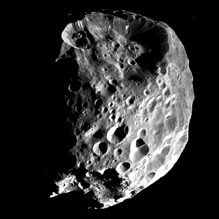
Phoebe is the most massive irregular satellite of Saturn with a mean diameter of 213 km (132 mi). It was discovered by William Henry Pickering on 18 March 1899 from photographic plates that had been taken by DeLisle Stewart starting on 16 August 1898 at the Boyden Station of the Carmen Alto Observatory near Arequipa, Peru. It was the first natural satellite to be discovered photographically.

<span class="mw-page-title-main">Moons of Saturn</span> Natural satellites of the planet Saturn

The moons of Saturn are numerous and diverse, ranging from tiny moonlets only tens of meters across to the enormous Titan, which is larger than the planet Mercury. There are 146 moons with confirmed orbits, the most of any planet in the solar system. This number does not include the many thousands of moonlets embedded within Saturn's dense rings, nor hundreds of possible kilometer-sized distant moons that were seen through telescopes but not recaptured. Seven Saturnian moons are large enough to have collapsed into a relaxed, ellipsoidal shape, though only one or two of those, Titan and possibly Rhea, are currently in hydrostatic equilibrium. Three moons are particularly notable. Titan is the second-largest moon in the Solar System, with a nitrogen-rich Earth-like atmosphere and a landscape featuring river networks and hydrocarbon lakes. Enceladus emits jets of ice from its south-polar region and is covered in a deep layer of snow. Iapetus has contrasting black and white hemispheres as well as an extensive ridge of equatorial mountains among the tallest in the solar system.

<span class="mw-page-title-main">Iapetus Ocean</span> Ocean that existed in the late Neoproterozoic and early Paleozoic eras

The Iapetus Ocean was an ocean that existed in the late Neoproterozoic and early Paleozoic eras of the geologic timescale. The Iapetus Ocean was situated in the southern hemisphere, between the paleocontinents of Laurentia, Baltica and Avalonia. The ocean disappeared with the Acadian, Caledonian and Taconic orogenies, when these three continents joined to form one big landmass called Euramerica. The "southern" Iapetus Ocean has been proposed to have closed with the Famatinian and Taconic orogenies, meaning a collision between Western Gondwana and Laurentia.

This is a directory of lists of geological features on planets excepting Earth, moons and asteroids ordered by increasing distance from the Sun.

<span class="mw-page-title-main">Roncevaux Terra</span>

Roncevaux Terra is the name given to the northern part of the highly reflective side of Saturn's moon Iapetus. The southern half of this side is named Saragossa Terra. The other half of Iapetus, named Cassini Regio, is extremely dark. It is believed that Roncevaux Terra's colour is the underlying colour of Iapetus, while Cassini Regio was formed either by a substance that has covered up the brighter ice of the rest of the moon, or by a residue left from the sublimation of Roncevaux-type water ice.

<span class="mw-page-title-main">Caledonian orogeny</span> Mountain building event caused by the collision of Laurentia, Baltica and Avalonia

The Caledonian orogeny was a mountain-building cycle recorded in the northern parts of the British Isles, the Scandinavian Caledonides, Svalbard, eastern Greenland and parts of north-central Europe. The Caledonian orogeny encompasses events that occurred from the Ordovician to Early Devonian, roughly 490–390 million years ago (Ma). It was caused by the closure of the Iapetus Ocean when the Laurentia and Baltica continents and the Avalonia microcontinent collided.

<span class="mw-page-title-main">Turgis (crater)</span> Largest crater on Saturns moon Iapetus

Turgis is the largest known crater on Saturn's moon Iapetus. It is 580 km in diameter, 40% of the moon's diameter and one of the larger craters in the Solar System. It is named after a Saracen baron, Turgis of Turtelose (Tortosa).

<span class="mw-page-title-main">Iapetus Suture</span> Ancient geological fault

The Iapetus Suture is one of several major geological faults caused by the collision of several ancient land masses forming a suture. It represents in part the remains of what was once the Iapetus Ocean. Iapetus was the father of Atlas in Greek mythology, making his an appropriate name for what used to be called the 'Proto-Atlantic Ocean'. When the Atlantic Ocean opened, in the Cretaceous period, it took a slightly different line from that of the Iapetus suture, with some originally Laurentian rocks being left behind in north-west Europe and other, Avalonian, rocks remaining as part of Newfoundland.

<span class="mw-page-title-main">Mons (planetary nomenclature)</span>

Mons is a mountain on a celestial body. The term is used in planetary nomenclature: it is a part of the international names of such features. It is capitalized and usually stands after the proper given name, but stands before it in the case of lunar mountains.

The following outline is provided as an overview of and topical guide to Saturn:

<span class="mw-page-title-main">Abisme</span>

Abisme /æˈbiːm/ is located in Cassini Regio at 37.9°N 267.1°E. Craters Climborin, Clarin, Dapamort, Johun and Valdebron can be found inside Abisme. It was imaged for the first time by the Cassini spacecraft in 2004.

References

  1. Iapetus, Gazetteer of Planetary Nomenclature