Chaos terrain

Last updated
Conamara Chaos on Europa Europa Chaos.jpg
Conamara Chaos on Europa

In astrogeology, chaos terrain, or chaotic terrain, is a planetary surface area where features such as ridges, cracks, and plains appear jumbled and enmeshed with one another. Chaos terrain is a notable feature of the planets Mars and Mercury, Jupiter's moon Europa, and the dwarf planet Pluto. In scientific nomenclature, "chaos" is used as a component of proper nouns (e.g., "Aureum Chaos" on Mars). [1]

Contents

On Mars

On April 1, 2010, NASA released the first images under the HiWish program in which citizens suggested places for HiRISE to photograph. One of the eight locations was Aureum Chaos. [2] The first image below gives a wide view of the area. The next two images are from the HiRISE image. [3]

On Mercury

On Mercury, chaos terrain can be hilly or lineated. An original theory for the formation of chaos terrain on Mercury is an impact basin on the opposite side of the planet. However, there is some terrain on Mercury that has no connections to an impact basin, so this theory doesn’t fully explain Mercury’s chaos terrain. [4]

A large portion of chaos terrain on Mercury is antipodal to the Caloris basin. They are the result of the ejecta and resurfacing caused by such a large impact. [4]

On Europa

Chaos terrain is plentiful on Europa, covering between 20 and 40% of the surface. While many theories have been proposed, none yet fully explains the origin of this terrain. [5] On Europa, “chaos terrain” includes geological features such as chaos lenticulae, pits, spots, and domes. Chaos terrain has been observed at both a higher and lower altitude than surrounding non-chaos terrain but is most often uplifted from nearby topography.

Nearly all observed chaos terrain lies on top of its surroundings, indicating chaos terrain is a relatively young feature on Europa. Chaos terrain can fall into two categories on Europa: “fresh” and “modified”. [5] Fresh chaos terrain is very young and has not been crosscut by other geological features. Modified chaos terrain is older, with smoother edges and crosscutting features.

A possible origin of the lenticulae on Europa’s surface is the strong gravitational pull of Jupiter. [6] As the surface is stretched and squished, the surface may crack and pull apart, or be pushed together. Another potential origin of various chaos terrain on Europa is interactions between the icy surface and liquid ocean under Europa’s surface. Warm water plumes can melt the surface of Europa, and then movements of the shell can move chaos terrain to a different location than where it was formed.

On Pluto

Chaos terrain on Pluto is not as well understood as that on other bodies. On Pluto, chaos terrain is referred to most often as “Montes” and are likely made up mostly of water ice, which at the temperature of Pluto’s surface acts as bedrock. Additionally, at Pluto’s temperature, nitrogen ice is not able to form the tall topographical features we observe around the Sputnik basin, further proving water ice as the main component of the montes formations.  Most of the montes on Pluto are on the outside edges of Sputnik Planitia, a giant impact basin. The cause of this is the uplift and disruption due to the high-energy impact. [7]

Causes

The specific causes of chaos terrain are not yet well understood. A number of different astrogeological forces have been offered as causes of chaos terrain. On Europa, impact events and subsequent penetration into a ductile or liquid crust were suggested in 2004. [8] In November 2011, a team of researchers from the University of Texas at Austin and elsewhere presented evidence in the journal Nature suggesting that many "chaos terrain" features on Europa sit atop vast lakes of liquid water. [9] These lakes would be entirely encased in the moon's icy outer shell and distinct from a liquid ocean thought to exist farther down beneath the ice shell. Rather than an external impact, the authors propose a four-step model for producing the surface expressions (chaos terrain) and the shallow, covered lakes. Full confirmation of the lakes' existence will require a space mission designed to probe the ice shell either physically or indirectly, for example using radar.

On Mars, chaos terrain is believed to be associated with the release of huge amounts of water. The chaotic features may have collapsed when water came out of the surface. Martian rivers begin with a chaos region. A chaotic region can be recognized by a rat's nest of mesas, buttes, and hills, chopped through with valleys which in places look almost patterned. Some parts of this chaotic area have not collapsed completely—they are still formed into large mesas, so they may still contain water ice. [10] Chaotic terrain occurs in numerous locations on Mars, and always gives the strong impression that something abruptly disturbed the ground. Chaos regions formed long ago. By counting craters (more craters in any given area means an older surface) and by studying the valleys' relations with other geological features, scientists have concluded the channels formed 2.0 to 3.8 billion years ago. [11]

Scientists have thought of different ideas for the cause of chaotic terrain. One explanation for the source of the water that quickly left the ground and created chaos is that water rich sediment was deposited in giant canyons on the floor of an ocean. Later, when the ocean disappeared, the sediments froze. If hot magma came near to the region, the ice would have melted and formed large underground river systems. When these neared the surface, huge amounts would break out of the ground and carve the valleys we see today. There is much evidence for an ocean on Mars. [12] [13] [14] [15] Places have been photographed that could be where the ground collapsed when water left subterranean rivers to flow out of chaotic regions. [16] [17] One of the first theories for the source of the water was based on old Viking Orbiter pictures. It was thought that these outflows came from a global cryosphere-confined aquifer that collected water from south polar meltwater. [18] [19] The cryosphere would have formed during the Hesperian period in the planet's history into the planet's upper crust. [17] One chaotic terrain, Galaxias Chaos may be caused by sublimation of an ice-rich deposit. [20]

See also

Related Research Articles

Vallis or valles is the Latin word for valley. It is used in planetary geology to name landform features on other planets.

<span class="mw-page-title-main">Ares Vallis</span> Vallis on Mars

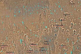
Ares Vallis is an outflow channel on Mars, named after the Greek name for Mars: Ares, the god of war; it appears to have been carved by fluids, perhaps water. The valley 'flows' northwest out of the hilly Margaritifer Terra, where the Iani Chaos depression 180 km (110 mi) long and 200 km (120 mi) wide) is connected to the beginning of Ares Vallis by a 100 km (62 mi) wide transition zone centered on 342.5° East and 3° North. It then continues through the ancient Xanthe Terra highlands, and ends in a delta-like region of Chryse Planitia. Ares Vallis was the landing site of NASA's Mars Pathfinder spacecraft, which studied a region of the valley near the border with Chryse in 1997.

<span class="mw-page-title-main">Margaritifer Terra</span> Terra on Mars

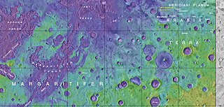
Margaritifer Terra is an ancient, heavily cratered region of Mars. It is centered just south of the Martian equator at 4.9°S 25°W and covers 2600 km at its widest extent. The area reveals "chaos terrain", outflow channels, and alluvial plains that are indicative of massive flooding. Wind erosion patterns are also in evidence. A region within the terra shows some of the highest valley network densities on the planet. Ares Vallis is another notable feature, where the flood and flow patterns are in evidence; it was the landing site of the Soviet Mars 6 lander and NASA's Mars Pathfinder. It is also one of several proposed landing sites for the Mars 2020 Rover.

<span class="mw-page-title-main">Aram Chaos</span> Crater on Mars

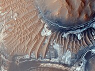
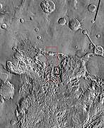
Aram Chaos, centered at 2.6°N, 21.5°W, is a heavily eroded impact crater on Mars. It lies at the eastern end of the large canyon Valles Marineris and close to Ares Vallis. Various geological processes have reduced it to a circular area of chaotic terrain. Aram Chaos takes its name from Aram, one of the classical albedo features observed by Giovanni Schiaparelli, who named it after the Biblical land of Aram. Spectroscopic observation from orbit indicates the presence of the mineral hematite, likely a signature of a once aqueous environment.

<span class="mw-page-title-main">Iani Chaos</span> Chaos on Mars

Iani Chaos is a region of chaos terrain at the south end of the outflow channel Ares Vallis, of the Margaritifer Sinus quadrangle (MC-19) region of the planet Mars, centered at approximately ~342°E, 2°S. This is the source region of Ares Vallis. The chaotic terrain is widely believed to have formed via the removal of subsurface water or ice, resulting in flooding at the surface, and the formation of Ares Vallis. Within Iani Chaos, deposited stratigraphically above the chaotic terrain, are smooth, low-slope, intermediate-to-light-toned deposits that are rich in a hydrated mineral that is most likely gypsum as well as hematite.

<span class="mw-page-title-main">Cebrenia quadrangle</span> One of 30 quadrangle maps of Mars used by the US Geological Survey

The Cebrenia quadrangle is one of a series of 30 quadrangle maps of Mars used by the United States Geological Survey (USGS) Astrogeology Research Program. The quadrangle is located in the northeastern portion of Mars' eastern hemisphere and covers 120° to 180° east longitude and 30° to 65° north latitude. The quadrangle uses a Lambert conformal conic projection at a nominal scale of 1:5,000,000 (1:5M). The Cebrenia quadrangle is also referred to as MC-7. It includes part of Utopia Planitia and Arcadia Planitia. The southern and northern borders of the Cebrenia quadrangle are approximately 3,065 km (1,905 mi) and 1,500 km (930 mi) wide, respectively. The north to south distance is about 2,050 km (1,270 mi). The quadrangle covers an approximate area of 4.9 million square km, or a little over 3% of Mars' surface area.

<span class="mw-page-title-main">Lunae Palus quadrangle</span> Quadrangle map of Mars

The Lunae Palus quadrangle is one of a series of 30 quadrangle maps of Mars used by the United States Geological Survey (USGS) Astrogeology Research Program. The quadrangle is also referred to as MC-10. Lunae Planum and parts of Xanthe Terra and Chryse Planitia are found in the Lunae Palus quadrangle. The Lunae Palus quadrangle contains many ancient river valleys.

<span class="mw-page-title-main">Oxia Palus quadrangle</span> Map of Mars

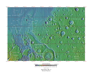
The Oxia Palus quadrangle is one of a series of 30 quadrangle maps of Mars used by the United States Geological Survey (USGS) Astrogeology Research Program. The Oxia Palus quadrangle is also referred to as MC-11.

<span class="mw-page-title-main">Sinus Sabaeus quadrangle</span> Map of Mars

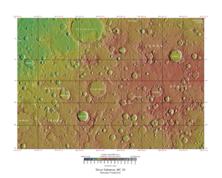
The Sinus Sabaeus quadrangle is one of a series of 30 quadrangle maps of Mars used by the United States Geological Survey (USGS) Astrogeology Research Program. It is also referred to as MC-20 . The Sinus Sabaeus quadrangle covers the area from 315° to 360° west longitude and 0° to 30° degrees south latitude on Mars. It contains Schiaparelli, a large, easily visible crater that sits close to the equator. The Sinus Sabaeus quadrangle contains parts of Noachis Terra and Terra Sabaea.

<span class="mw-page-title-main">Coprates quadrangle</span> Map of Mars

The Coprates quadrangle is one of a series of 30 quadrangle maps of Mars used by the United States Geological Survey (USGS) Astrogeology Research Program. The Coprates quadrangle is also referred to as MC-18. The Coprates quadrangle contains parts of many of the old classical regions of Mars: Sinai Planum, Solis Planum, Thaumasia Planum, Lunae Planum, Noachis Terra, and Xanthe Terra.

<span class="mw-page-title-main">Margaritifer Sinus quadrangle</span> One of a series of 30 quadrangle maps of Mars

The Margaritifer Sinus quadrangle is one of a series of 30 quadrangle maps of Mars used by the United States Geological Survey (USGS) Astrogeology Research Program. The Margaritifer Sinus quadrangle is also referred to as MC-19. The Margaritifer Sinus quadrangle covers the area from 0° to 45° west longitude and 0° to 30° south latitude on Mars. Margaritifer Sinus quadrangle contains Margaritifer Terra and parts of Xanthe Terra, Noachis Terra, Arabia Terra, and Meridiani Planum.

<span class="mw-page-title-main">Hydaspis Chaos</span> Chaos on Mars

Hydaspis Chaos is a region in the Oxia Palus quadrangle of Mars, located at 3.2° north latitude and 27.1° west longitude. The region is about 355 km across. It was named after a classical albedo feature.

<span class="mw-page-title-main">Shalbatana Vallis</span> Martian landscape feature

Shalbatana Vallis is an ancient water-worn channel on Mars, located in the Oxia Palus quadrangle at 7.8° north latitude and 42.1° west longitude. It is the westernmost of the southern Chryse outflow channels. Beginning in a zone of chaotic terrain, at 0° latitude and 46° W longitude, it ends in Chryse Planitia.

<span class="mw-page-title-main">Aureum Chaos</span> Chaos on Mars

Aureum Chaos is a rough, collapsed region in the Margaritifer Sinus quadrangle (MC-19) portion of the planet Mars at approximately 4.4° south latitude and 27° west longitude, it is also in the west of Margaritifer Terra. It is 368 km across and was named after a classical albedo feature name.

To date, interplanetary spacecraft have provided abundant evidence of water on Mars, dating back to the Mariner 9 mission, which arrived at Mars in 1971. This article provides a mission by mission breakdown of the discoveries they have made. For a more comprehensive description of evidence for water on Mars today, and the history of water on that planet, see Water on Mars.

The Mars orbiter 2001 Mars Odyssey found much evidence for water on Mars in the form of pictures, and with a spectrometer it proved that much of the ground is loaded with ice.

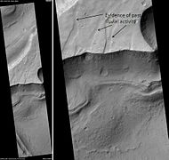
Chaos terrain on Mars is distinctive; nothing on Earth compares to it. Chaos terrain generally consists of irregular groups of large blocks, some tens of kilometers across and a hundred or more meters high. The tilted and flat topped blocks form depressions hundreds of metres deep. A chaotic region can be recognized by a rat's nest of mesas, buttes, and hills, chopped through with valleys which in places look almost patterned. Some parts of this chaotic area have not collapsed completely—they are still formed into large mesas, so they may still contain water ice. Chaos regions formed long ago. By counting craters and by studying the valleys' relations with other geological features, scientists have concluded the channels formed 2.0 to 3.8 billion years ago.

The common surface features of Mars include dark slope streaks, dust devil tracks, sand dunes, Medusae Fossae Formation, fretted terrain, layers, gullies, glaciers, scalloped topography, chaos terrain, possible ancient rivers, pedestal craters, brain terrain, and ring mold craters.

<span class="mw-page-title-main">Arsinoes Chaos</span> Chaos terrain on Mars

Arsinoes Chaos is a chaos terrain in the Margaritifer Sinus quadrangle on Mars. It is 200 km in diameter. Its location is 7.66 °S and 27.9 °W. Arsinoes Chaos was named after Arsinoe, a queen of ancient Egypt, daughter of Ptolemy and Berenice.

<span class="mw-page-title-main">Equatorial layered deposits</span> Surface geological deposits on Mars

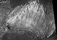
Equatorial layered deposits (ELD’s) have been called interior layered deposits (ILDs) in Valles Marineris. They are often found with the most abundant outcrops of hydrated sulfates on Mars, and thus are likely to preserve a record of liquid water in Martian history since hydrated sulfates are formed in the presence of water. Layering is visible on meter scale, and when the deposits are partly eroded, intricate patterns become visible. The layers in the mound in Gale Crater have been extensively studied from orbit by instruments on the Mars Reconnaissance Orbiter. The Curiosity Rover landed in the crater, and it has brought some ground truth to the observations from satellites. Many of the layers in ELD’s such as in Gale Crater are composed of fine-grained, easily erodible material as are many other layered deposits. On the basis of albedo, erosion patterns, physical characteristics, and composition, researchers have classified different groups of layers in Gale Crater that seem to be similar to layers in other (ELD’s). The groups include: a small yardang unit, a coarse yardang unit, and a terraced unit. Generally, equatorial layered deposits are found ~ ±30° of the equator. Equatorial Layered Deposits appear in various geological settings such as cratered terrains, chaotic terrains, the Valles Marineris chasmata, and large impact craters.

References

  1. Britt, Robert Roy (April 25, 2005). "Chaos on Mars". Space.com.
  2. "Captioned Images Inspired by HiWish Suggestions". HiRISE. Archived from the original on Dec 24, 2016.
  3. Okubo, Chris (March 2010). "Mesas in Aureum Chaos". HiRISE.
  4. 1 2 Rodriguez, J. Alexis P.; Leonard, Gregory J.; Kargel, Jeffrey S.; Domingue, Deborah; Berman, Daniel C.; Banks, Maria; Zarroca, Mario; Linares, Rogelio; Marchi, Simone; Baker, Victor R.; Webster, Kevin D.; Sykes, Mark (2020-03-16). "The Chaotic Terrains of Mercury Reveal a History of Planetary Volatile Retention and Loss in the Innermost Solar System". Scientific Reports. 10 (1): 4737. Bibcode:2020NatSR..10.4737R. doi:10.1038/s41598-020-59885-5. ISSN   2045-2322. PMC   7075900 . PMID   32179758.
  5. 1 2 Collins, Geoffrey; Nimmo, Francis (2009). Europa. pp. 259–282.
  6. Schmidt, B. E.; Blankenship, D. D.; Patterson, G. W.; Schenk, P. M. (November 2011). "Active formation of 'chaos terrain' over shallow subsurface water on Europa". Nature. 479 (7374): 502–505. Bibcode:2011Natur.479..502S. doi:10.1038/nature10608. ISSN   1476-4687. PMID   22089135. S2CID   4405195.
  7. Skjetne, Helle L.; Singer, Kelsi N.; Hynek, Brian M.; Knight, Katie I.; Schenk, Paul M.; Olkin, Cathy B.; White, Oliver L.; Bertrand, Tanguy; Runyon, Kirby D.; McKinnon, William B.; Moore, Jeffrey M.; Stern, S. Alan; Weaver, Harold A.; Young, Leslie A.; Ennico, Kim (2021-03-01). "Morphological comparison of blocks in chaos terrains on Pluto, Europa, and Mars". Icarus. Pluto System, Kuiper Belt, and Kuiper Belt Objects. 356: 113866. arXiv: 2104.12033 . Bibcode:2021Icar..35613866S. doi:10.1016/j.icarus.2020.113866. ISSN   0019-1035. S2CID   219506634.
  8. Ong, Lissa (November 7, 2004). Evidence that chaos terrain on Jupiter's moon Europa is formed by crust-penetrating impacts. Geological Society of America Abstracts with Programs. Vol. 36. p. 144. Archived from the original on 2007-03-12.
  9. Schmidt, Britney; Blankenship, Don; Patterson, Wes; Schenk, Paul (November 24, 2011). "Active formation of 'chaos terrain' over shallow subsurface water on Europa". Nature. 479 (7374): 502–505. Bibcode:2011Natur.479..502S. doi:10.1038/nature10608. PMID   22089135. S2CID   4405195.
  10. "Unraveling the Chaos of Aram". Mars Odyssey THEMIS (THermal Emission Imaging System). Arizona State University.
  11. "Feature Image: Volcanism and Collapse in Hydraotes". Mars Odyssey THEMIS (THermal Emission Imaging System). Arizona State University. 2008-11-26. Retrieved 2021-04-22.
  12. Baker, V. R.; Strom, R. G.; Gulick, V. C.; Kargel, J. S.; Komatsu, G.; Kale, V. S. (1991). "Ancient oceans, ice sheets and the hydrological cycle on Mars". Nature. 352 (6336): 589–594. Bibcode:1991Natur.352..589B. doi:10.1038/352589a0. ISSN   0028-0836. S2CID   4321529.
  13. Head III, J. W. (10 December 1999). "Possible Ancient Oceans on Mars: Evidence from Mars Orbiter Laser Altimeter Data" (PDF). Science. 286 (5447): 2134–2137. Bibcode:1999Sci...286.2134H. doi:10.1126/science.286.5447.2134. ISSN   0036-8075. PMID   10591640 via NASA Mars Exploration.
  14. Carr, Michael H. (2003). "Oceans on Mars: An assessment of the observational evidence and possible fate". Journal of Geophysical Research. 108 (E5): 5042. Bibcode:2003JGRE..108.5042C. doi: 10.1029/2002JE001963 . ISSN   0148-0227.
  15. Kreslavsky, Mikhail A.; Head, James W. (2002). "Fate of outflow channel effluents in the northern lowlands of Mars: The Vastitas Borealis Formation as a sublimation residue from frozen ponded bodies of water". Journal of Geophysical Research: Planets. 107 (E12): 4-1–4-25. Bibcode:2002JGRE..107.5121K. doi: 10.1029/2001JE001831 . ISSN   0148-0227.
  16. Cowing, Keith (September 11, 2015). "Regional, Not Global, Processes Led to Huge Martian Floods". SpaceRef. Archived from the original on September 29, 2015. Retrieved September 14, 2015.
  17. 1 2 Rodriguez, J. Alexis P.; Kargel, Jeffrey S.; Baker, Victor R.; et al. (2015). "Martian outflow channels: How did their source aquifers form, and why did they drain so rapidly?". Scientific Reports. 5: 13404. Bibcode:2015NatSR...513404R. doi:10.1038/srep13404. PMC   4562069 . PMID   26346067.
  18. Clifford, Stephen M. (25 June 1993). "A model for the hydrologic and climatic behavior of water on Mars". Journal of Geophysical Research. 98 (E6): 10973–11016. Bibcode:1993JGR....9810973C. doi:10.1029/93JE00225. ISSN   0148-0227.
  19. Clifford, S (2001). "The Evolution of the Martian Hydrosphere: Implications for the Fate of a Primordial Ocean and the Current State of the Northern Plains" (PDF). Icarus. 154 (1): 40–79. Bibcode:2001Icar..154...40C. doi:10.1006/icar.2001.6671. ISSN   0019-1035 via University of California, Berkeley Seismology Lab.
  20. Pedersen, G.B.M.; Head, J.W. (2011). "Chaos formation by sublimation of volatile-rich substrate: Evidence from Galaxias Chaos, Mars" (PDF). Icarus. 211 (1): 316–329. Bibcode:2011Icar..211..316P. doi:10.1016/j.icarus.2010.09.005. ISSN   0019-1035. Archived from the original (PDF) on Jan 29, 2013 via Department of Earth, Environmental & Planetary Sciences | Brown University.