
This is a list of all named mountains on Mars.
This is a list of all named mountains on Mars.
Most Martian mountains have a name including one of the following astrogeological terms:
Listed are the elevations of the peaks (the vertical position relative to the areoid, which is the Martian vertical datum — the surface defined as zero elevation by average martian atmospheric pressure and planet radius), which is not the height above the surrounding terrain (topographic prominence). Listed mons elevation is the highest point (at 16 pixels/degree) within the feature. Listed patera elevation is the average elevation of the shallow dish-shaped depression (the actual 'patera') at the summit.


Mars Global Surveyor (MGS) was an American robotic space probe developed by NASA's Jet Propulsion Laboratory and launched November 1996. MGS was a global mapping mission that examined the entire planet, from the ionosphere down through the atmosphere to the surface. As part of the larger Mars Exploration Program, Mars Global Surveyor performed atmospheric monitoring for sister orbiters during aerobraking, and helped Mars rovers and lander missions by identifying potential landing sites and relaying surface telemetry.

Areography, also known as the geography of Mars, is a subfield of planetary science that entails the delineation and characterization of regions on Mars. Areography is mainly focused on what is called physical geography on Earth; that is the distribution of physical features across Mars and their cartographic representations. In April 2023, The New York Times reported an updated global map of Mars based on images from the Hope spacecraft. A related, but much more detailed, global Mars map was released by NASA on 16 April 2023.

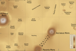
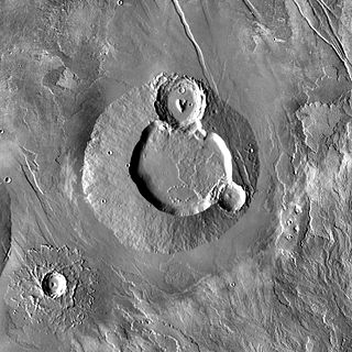
Pavonis Mons is a large shield volcano located in the Tharsis region of the planet Mars. It is the middle member of a chain of three volcanic mountains that straddle the Martian equator between longitudes 235°E and 259°E. The volcano was discovered by the Mariner 9 spacecraft in 1971, and was originally called Middle Spot. Its name formally became Pavonis Mons in 1973. The equatorial location of its peak and its height make it the ideal terminus for a space elevator, and it has often been proposed as a space elevator location, especially in science fiction. It is also an ideal location for a Sky Ramp.

Ascraeus Mons is a large shield volcano located in the Tharsis region of the planet Mars. It is the northernmost and tallest of three shield volcanoes collectively known as the Tharsis Montes.

The Tharsis Montes are three large shield volcanoes in the Tharsis region of the planet Mars. From north to south, the volcanoes are Ascraeus Mons, Pavonis Mons and Arsia Mons. Mons is the Latin word for mountain; it is a descriptor term used in astrogeology for mountainous features in the Solar System.
In planetary nomenclature, a fossa is a long, narrow depression (trough) on the surface of an extraterrestrial body, such as a planet or moon. The term, which means "ditch" or "trench" in Latin, is not a geological term as such but a descriptor term used by the United States Geological Survey (USGS) and the International Astronomical Union (IAU) for topographic features whose geology or geomorphology is uncertain due to lack of data or knowledge of the exact processes that formed them. Fossae are believed to be the result of a number of geological processes, such as faulting or subsidence. Many fossae on Mars are probably graben.
Hecates Tholus is a Martian volcano, notable for results from the European Space Agency's Mars Express mission which indicate a major eruption took place 350 million years ago. The eruption created a caldera 10 km in diameter on the volcano's western flank.
Elysium Mons is a volcano on Mars located in the volcanic province Elysium, at 25.02°N 147.21°E, in the Martian eastern hemisphere. It stands about 12.6 km (41,000 ft) above its base, and about 14.1 km (46,000 ft) above the Martian datum, making it the third tallest Martian mountain in terms of relief and the fourth highest in elevation. Its diameter is about 240 km (150 mi), with a summit caldera about 14 km (8.7 mi) across. It is flanked by the smaller volcanoes Hecates Tholus to the northeast, and Albor Tholus to the southeast.
In planetary nomenclature, a tholus is a small domical mountain or hill. The word is from the Greek θόλος, tholos, which means a circular building with a conical or vaulted roof. The Romans transliterated the word into the Latin tholus, which means cupola or dome. In 1973, the International Astronomical Union (IAU) adopted tholus as one of a number of official descriptor terms for topographic features on Mars and other planets and satellites. One justification for using neutral Latin or Greek descriptors was that it allowed features to be named and described before their geology or geomorphology could be determined. For example, many tholi appear to be volcanic in origin, but the term does not imply a specific geologic origin. Currently, the IAU recognizes 56 descriptor terms. Tholi are present on Venus, Mars, asteroid 4 Vesta, dwarf planet Ceres, and on Jupiter's moon Io.

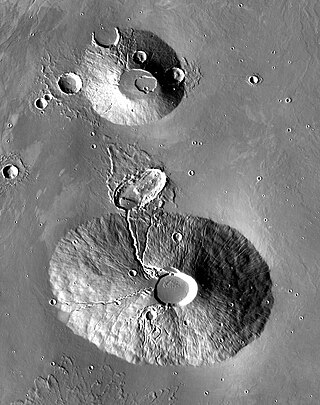
Biblis Tholus is an extinct Martian volcano located at 2.55°N 235.62°E, one of two volcanoes near the center of the Tharsis volcanism. Along with Ulysses Tholus, it is almost midway between Olympus Mons and the Tharsis Montes. Biblis Tholus lies in the Tharsis quadrangle. It is approximately 170 kilometers (110 mi) long and 100 kilometers (62 mi) wide, rising about 3 kilometers (1.9 mi) from its surroundings.

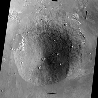
Apollinaris Mons is an ancient shield volcano in the southern hemisphere of Mars. It is situated near the equator, south of Elysium Planitia and north of the impact crater Gusev. Elysium Planitia separates it from the volcanic province of Elysium to its northwest. The volcano's caldera is named Apollinaris Patera; this name formerly applied to the whole edifice.
Volcanic activity, or volcanism, has played a significant role in the geologic evolution of Mars. Scientists have known since the Mariner 9 mission in 1972 that volcanic features cover large portions of the Martian surface. These features include extensive lava flows, vast lava plains, and the largest known volcanoes in the Solar System. Martian volcanic features range in age from Noachian to late Amazonian, indicating that the planet has been volcanically active throughout its history, and some speculate it probably still is so today. Both Earth and Mars are large, differentiated planets built from similar chondritic materials. Many of the same magmatic processes that occur on Earth also occurred on Mars, and both planets are similar enough compositionally that the same names can be applied to their igneous rocks and minerals.

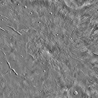
Tharsis Tholus is an intermediate-sized shield volcano located in the eastern Tharsis region of the planet Mars. The volcano was discovered by the Mariner 9 spacecraft in 1972 and originally given the informal name Volcano 7. In 1973, the International Astronomical Union (IAU) officially designated it Tharsis Tholus. In planetary geology, tholus is the term for a small domical mountain, usually a volcano.

The Tharsis quadrangle is one of a series of 30 quadrangle maps of Mars used by the United States Geological Survey (USGS) Astrogeology Research Program. The Tharsis quadrangle is also referred to as MC-9 . The name Tharsis refers to a land mentioned in the Bible. It may be at the location of the old town of Tartessus at the mouth of Guadalquivir.
Ulysses Tholus is a Martian volcano. It is located in the Tharsis quadrangle at 2.89° north latitude and 121.55° west longitude. It is 58 km across and is named after a classical albedo feature. Ulysses Tholus is immediately east and slightly north of another volcano, Biblis Tholus. The name of the mountain itself was changed on September 19, 2007. The former terminology, Ulysses Patera, now applies only to the central caldera, whereas formerly it had applied to the whole edifice. Tholus describes a volcanic edifice somewhat smaller than would be implied by mons.
Ceraunius Tholus is a volcano on Mars located in the Tharsis quadrangle at 24.25° north latitude and 262.75° east longitude, part of the Uranius group of volcanoes. It is 130 kilometres (81 mi) across, approximately 8,500 metres (27,887 ft) high and is named after a classical albedo feature name.
Uranius Tholus is a volcano on Mars located in the Tharsis quadrangle at 26.52° north latitude and 262.43° east longitude. It is 61.4 kilometres (38 mi) across with an elevation of 4,290 metres (14,075 ft) and was named after a classical albedo feature name.

Tyrrhenus Mons, formerly Tyrrhena Mons or Tyrrhena Patera, is a large volcano in the Mare Tyrrhenum quadrangle of Mars, located at 21.36° south latitude and 253.47° west longitude. The name "Tyrrhena Patera" now refers only to the central depression, a volcanic crater or caldera. It was named after a classical albedo feature name. Pit chains are found at the summit of Tyrrhenus Mons. They are formed by collapse of material into underground voids. Since they form chains and concentric fractures that are aligned, they are probably caused by extension of the surface. Volcanic processes made the crust pull apart. Voids were formed, then material fell into them, leaving holes. It is one of the oldest volcanoes on Mars. As a consequence of its old age, Tyrrhenus Mons has many radiating gullies on its slope. When it was formed, magma may have gone through frozen ground and then erupted as easily eroded ash, instead of lava flows.

Hesperia Planum is a broad lava plain in the southern highlands of the planet Mars. The plain is notable for its moderate number of impact craters and abundant wrinkle ridges. It is also the location of the ancient volcano Tyrrhena Mons. The Hesperian time period on Mars is named after Hesperia Planum.
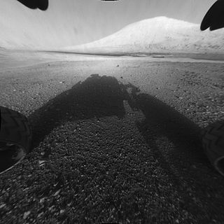
Mount Sharp, officially Aeolis Mons, is a mountain on Mars. It forms the central peak within Gale crater and is located around 5.08°S 137.85°E, rising 5.5 km (18,000 ft) high from the valley floor. Its ID in the United States Geological Survey's Gazetteer of Planetary Nomenclature is 15000.
| Geography | |||||||||||
|---|---|---|---|---|---|---|---|---|---|---|---|
| Astronomy |
| ||||||||||
| Exploration |
| ||||||||||
| Related | |||||||||||