Vastitas Borealis

Last updated

Vastitas Borealis
Mars topography (MOLA dataset) with poles HiRes.jpg
Vastitas Borealis is the large low elevation area surrounding 70°N.
LocationNorthern Hemisphere, Mars
Coordinates 87°44′N32°32′E / 87.73°N 32.53°E / 87.73; 32.53
Length0–360 E
Width48.25–82.08 N
Diameter2002.91 km
Depth4–5 km
NamingLatin

Vastitas Borealis ( Latin for 'northern waste') [1] is the largest lowland region of Mars. It is in the northerly latitudes of the planet and encircles the northern polar region. [2] Vastitas Borealis is often simply referred to as the northern plains, northern lowlands or the North polar erg [3] of Mars. The plains lie 4–5 km below the mean radius of the planet, and is centered at 87°44′N32°32′E / 87.73°N 32.53°E / 87.73; 32.53 . [4] A small part of Vastitas Borealis lies in the Ismenius Lacus quadrangle.

Contents

The region was named by Eugene Antoniadi, who noted the distinct albedo feature of the Northern plains in his book La Planète Mars (1930). The name was officially adopted by the International Astronomical Union in 1973. [5]

Although it is not an officially recognized feature, the North Polar Basin makes up most of the lowlands in the Northern Hemisphere of Mars. [6] [7] As a result, Vastitas Borealis lies within the North Polar Basin, while Utopia Planitia, another very large basin, is adjacent to it. Some scientists have speculated the plains were covered by a hypothetical ocean at some point in Mars' history and putative shorelines have been suggested for its southern edges. Today these mildly sloping plains are marked by ridges, low hills, and sparse cratering. Vastitas Borealis is noticeably smoother than similar topographical areas in the south.

In 2005 the European Space Agency's Mars Express spacecraft imaged a substantial quantity of water ice in a crater in the Vastitas Borealis region. The environmental conditions at the locality of this feature are suitable for water ice to remain stable. It was revealed after overlaying frozen carbon dioxide sublimated away at the commencement of the Northern Hemisphere Summer and is believed to be stable throughout the Martian year. [8]

A NASA probe named Phoenix landed safely in a region of Vastitas Borealis unofficially named Green Valley on 25 May 2008 (in the early Martian summer). Phoenix landed at 68.218830°N 234.250778°E. [9] The probe, which will remain stationary, collected and analyzed soil samples in an effort to detect water and determine how hospitable the planet might once have been for life to grow. It remained active there until winter conditions became too harsh around five months later. [10]

Surface

Surface of Mars, as seen by Phoenix. The ground is shaped into polygons which are common where the ground freezes and thaws. Phoenix mission horizon stitched high definition.jpg
Surface of Mars, as seen by Phoenix . The ground is shaped into polygons which are common where the ground freezes and thaws.

Unlike some the sites visited by the Viking and Pathfinder landers, nearly all the rocks near the Phoenix landing site on Vastitas Borealis are small. For about as far as the camera can see, the land is flat, but shaped into polygons. The polygons are between 2–3 m in diameter and are bounded by troughs that are 20 to 50 cm deep. These shapes are caused by ice in the soil reacting to major temperature changes. [11] The top of the soil has a crust. The microscope showed that the soil is composed of flat particles (probably a type of clay) and rounded particles. When the soil is scooped up, it clumps together. Although other landers in other places on Mars have seen many ripples and dunes, no ripples or dunes are visible in the area of Phoenix. Ice is present a few inches below the surface in the middle of the polygons. Along the edge of the polygons the ice is at least 8 inches deep. When the ice is exposed to the Martian atmosphere it slowly disappears. [12] In the winter there would be accumulations of snow on the surface. [13]

Surface chemistry

Results published in the journal Science after the Phoenix mission ended reported that chloride, bicarbonate, magnesium, sodium, potassium, calcium, and possibly sulfate were detected in the samples. The pH was narrowed down to 7.7±0.5. Perchlorate (ClO4), a strong oxidizer, was detected. This was a significant discovery. The chemical has the potential of being used for rocket fuel and as a source of oxygen for future colonists. Under certain conditions perchlorate can inhibit life; however some microorganisms obtain energy from the substance (by anaerobic reduction). The chemical when mixed with water can greatly lower freezing points, in a manner similar to how salt is applied to roads to melt ice. Perchlorate strongly attracts water; consequently it could pull humidity from the air and produce a small amount of liquid water on Mars today. [14] Gullies, which are common in certain areas of Mars, may have formed from perchlorate melting ice and causing water to erode soil on steep slopes. [15] Two sets of experiments demonstrated that the soil contains 3–5% calcium carbonate. When a sample was slowly heated in the Thermal and Evolved-Gas Analyzer (TEGA), a peak occurred at 725 °C, which is what would happen if calcium carbonate were present. In a second experiment acid was added to a soil sample in the Wet Chemistry Laboratory (WCL) while a pH electrode measured the pH. Since the pH rose from 3.3 to 7.7, it was concluded that calcium carbonate was present. Calcium carbonate changes the texture of soil by cementing particles. Having calcium carbonate in the soil may be easier on life forms because it buffers acids, creating a pH more friendly toward life. [16]

Patterned ground

Much of the surface of Vastitas Borealis is covered with patterned ground. Sometimes the ground has the shape of polygons. Close-up views of patterned ground in the shape of polygons was provided by the Phoenix lander. In other places, the surface has low mounds arranged in chains. Some scientists first called the features fingerprint terrain because the many lines looked like someone's fingerprint. [17] Similar features in both shape and size are found in terrestrial periglacial regions such as Antarctica. Antarctica's polygons are formed by repeated expansion and contraction of the soil-ice mixture due to seasonal temperature changes. When dry soil falls into cracks sand wedges are made which increase this effect. This process results in polygonal networks of stress fractures. [18]

Defrosting

In the spring, various shapes appear because frost is disappearing from the surface, exposing the underling dark soil. Also, in some places dust is blown out of in geyser-like eruptions that are sometimes called "spiders." If a wind is blowing, the material creates a long, dark streak or fan.

Glaciers

Glaciers formed much of the observable surface in large areas of Mars. Much of the area in high latitudes is believed to still contain enormous amounts of water ice. [20] In March 2010, scientists released the results of a radar study of an area called Deuteronilus Mensae that found widespread evidence of ice lying beneath a few meters of rock debris. The ice was probably deposited as snowfall during an earlier climate when the poles were tilted more. [21] Some features in Vastitas Borealis are believed to be ancient glaciers as shown in the pictures below.

Layers

Where the ice cap is exposed in certain places, it is found to contain many layers. Some are shown in the picture below.

Dunes

Climate

Weather

The Phoenix lander provided several months of weather observations from Mare Boreum. Wind speeds ranged from 11 to 58 km per hour. The usual average speed was 36 km per hour. [22] The highest temperature measured during the mission was −19.6 °C, while the coldest was −97.7 °C. [23] Dust devils were observed. [24]

Cirrus clouds that produced snow were sighted in Phoenix imagery. The clouds formed at a level in the atmosphere that was around −65 °C, so the clouds would have to be composed of water-ice, rather than carbon dioxide-ice because the temperature for forming carbon dioxide ice is much lower—less than −120 °C. As a result of the mission, it is now believed that water ice (snow) would have accumulated later in the year at this location. [13]

Scientists think that water ice was transported downward by snow at night. It sublimated (went directly from ice to vapor) in the morning. Throughout the day convection and turbulence mixed it back into the atmosphere. [13]

Climate cycles

Interpretation of the data transmitted from the Phoenix craft was published in the journal Science. As per the peer reviewed data the presence of water ice has been confirmed and that the site had a wetter and warmer climate in the recent past. Finding calcium carbonate in the Martian soil leads scientists to believe that the site had been wet or damp in the geological past. During seasonal or longer period diurnal cycles water may have been present as thin films. The tilt or obliquity of Mars changes far more than the Earth; hence times of higher humidity are probable. [25]

Interactive Mars map

Interactive image map of the global topography of Mars. Hover your mouse over the image to see the names of over 60 prominent geographic features, and click to link to them. Coloring of the base map indicates relative elevations, based on data from the Mars Orbiter Laser Altimeter on NASA's Mars Global Surveyor. Whites and browns indicate the highest elevations (+12 to +8 km); followed by pinks and reds (+8 to +3 km); yellow is 0 km; greens and blues are lower elevations (down to -8 km). Axes are latitude and longitude; Polar regions are noted.
(See also: Mars Rovers map and Mars Memorial map) (view * discuss) Mars Map.JPGCydonia MensaeGale craterHolden craterJezero craterLomonosov craterLyot craterMalea PlanumMaraldi craterMareotis TempeMie craterMilankovič craterSisyphi Planum
Interactive icon.svg Interactive image map of the global topography of Mars. Hover your mouse over the image to see the names of over 60 prominent geographic features, and click to link to them. Coloring of the base map indicates relative elevations, based on data from the Mars Orbiter Laser Altimeter on NASA's Mars Global Surveyor . Whites and browns indicate the highest elevations (+12 to +8 km); followed by pinks and reds (+8 to +3 km); yellow is 0 km; greens and blues are lower elevations (down to −8 km). Axes are latitude and longitude; Polar regions are noted.

See also

Related Research Articles

<span class="mw-page-title-main">Tempe Terra</span> Terra on Mars

Tempe Terra is a heavily cratered highland region in the northern hemisphere of the planet Mars. Located at the northeastern edge of the Tharsis volcanic province, Tempe Terra is notable for its high degree of crustal fracturing and deformation. The region also contains many small shield volcanoes, lava flows, and other volcanic structures.

<span class="mw-page-title-main">Terra Sabaea</span> Terra on Mars

Terra Sabaea is a large area on Mars. Its coordinates are 2°N42°E and it covers 4,700 kilometres (2,900 mi) at its broadest extent. It was named in 1979 after a classic albedo feature on the planet. Terra Sabaea is fairly large and parts of it are found in five quadrangles: Arabia quadrangle, Syrtis Major quadrangle, Iapygia quadrangle, Ismenius Lacus quadrangle, and Sinus Sabaeus quadrangle.

<span class="mw-page-title-main">Planum Boreum</span> Planum on Mars

Planum Boreum is the northern polar plain on Mars. It extends northward from roughly 80°N and is centered at 88.0°N 15.0°E. Surrounding the high polar plain is a flat and featureless lowland plain called Vastitas Borealis which extends for approximately 1500 kilometers southwards, dominating the northern hemisphere.

<span class="mw-page-title-main">Mare Boreum quadrangle</span> Map of Mars

The Mare Boreum quadrangle is one of a series of 30 quadrangle maps of Mars used by the United States Geological Survey (USGS) Astrogeology Research Program. The Mare Boreum quadrangle is also referred to as MC-1. Its name derives from an older name for a feature that is now called Planum Boreum, a large plain surrounding the polar cap.

<span class="mw-page-title-main">Ismenius Lacus quadrangle</span> Map of Mars

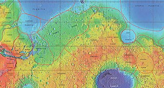
The Ismenius Lacus quadrangle is one of a series of 30 quadrangle maps of Mars used by the United States Geological Survey (USGS) Astrogeology Research Program. The quadrangle is located in the northwestern portion of Mars' eastern hemisphere and covers 0° to 60° east longitude and 30° to 65° north latitude. The quadrangle uses a Lambert conformal conic projection at a nominal scale of 1:5,000,000 (1:5M). The Ismenius Lacus quadrangle is also referred to as MC-5. The southern and northern borders of the Ismenius Lacus quadrangle are approximately 3,065 km (1,905 mi) and 1,500 km (930 mi) wide, respectively. The north-to-south distance is about 2,050 km (1,270 mi). The quadrangle covers an approximate area of 4.9 million square km, or a little over 3% of Mars' surface area. The Ismenius Lacus quadrangle contains parts of Acidalia Planitia, Arabia Terra, Vastitas Borealis, and Terra Sabaea.

<span class="mw-page-title-main">Casius quadrangle</span> Map of Mars

The Casius quadrangle is one of a series of 30 quadrangle maps of Mars used by the United States Geological Survey (USGS) Astrogeology Research Program. The quadrangle is located in the north-central portion of Mars’ eastern hemisphere and covers 60° to 120° east longitude and 30° to 65° north latitude. The quadrangle uses a Lambert conformal conic projection at a nominal scale of 1:5,000,000 (1:5M). The Casius quadrangle is also referred to as MC-6. Casius quadrangle contains part of Utopia Planitia and a small part of Terra Sabaea. The southern and northern borders of the Casius quadrangle are approximately 3,065 km and 1,500 km wide, respectively. The north to south distance is about 2,050 km. The quadrangle covers an approximate area of 4.9 million square km, or a little over 3% of Mars’ surface area.

<span class="mw-page-title-main">Cebrenia quadrangle</span> One of 30 quadrangle maps of Mars used by the US Geological Survey

The Cebrenia quadrangle is one of a series of 30 quadrangle maps of Mars used by the United States Geological Survey (USGS) Astrogeology Research Program. The quadrangle is located in the northeastern portion of Mars’ eastern hemisphere and covers 120° to 180° east longitude and 30° to 65° north latitude. The quadrangle uses a Lambert conformal conic projection at a nominal scale of 1:5,000,000 (1:5M). The Cebrenia quadrangle is also referred to as MC-7. It includes part of Utopia Planitia and Arcadia Planitia. The southern and northern borders of the Cebrenia quadrangle are approximately 3,065 km (1,905 mi) and 1,500 km (930 mi) wide, respectively. The north to south distance is about 2,050 km (1,270 mi). The quadrangle covers an approximate area of 4.9 million square km, or a little over 3% of Mars’ surface area.

<span class="mw-page-title-main">Diacria quadrangle</span> Map of Mars

The Diacria quadrangle is one of a series of 30 quadrangle maps of Mars used by the United States Geological Survey (USGS) Astrogeology Research Program. The quadrangle is located in the northwestern portion of Mars’ western hemisphere and covers 180° to 240° east longitude and 30° to 65° north latitude. The quadrangle uses a Lambert conformal conic projection at a nominal scale of 1:5,000,000 (1:5M). The Diacria quadrangle is also referred to as MC-2. The Diacria quadrangle covers parts of Arcadia Planitia and Amazonis Planitia.

<span class="mw-page-title-main">Mare Acidalium quadrangle</span> Map of Mars

The Mare Acidalium quadrangle is one of a series of 30 quadrangle maps of Mars used by the United States Geological Survey (USGS) Astrogeology Research Program. The quadrangle is located in the northeastern portion of Mars’ western hemisphere and covers 300° to 360° east longitude and 30° to 65° north latitude. The quadrangle uses a Lambert conformal conic projection at a nominal scale of 1:5,000,000 (1:5M). The Mare Acidalium quadrangle is also referred to as MC-4.

<span class="mw-page-title-main">Lunae Palus quadrangle</span> Quadrangle map of Mars

The Lunae Palus quadrangle is one of a series of 30 quadrangle maps of Mars used by the United States Geological Survey (USGS) Astrogeology Research Program. The quadrangle is also referred to as MC-10. Lunae Planum and parts of Xanthe Terra and Chryse Planitia are found in the Lunae Palus quadrangle. The Lunae Palus quadrangle contains many ancient river valleys.

<span class="mw-page-title-main">Hellas quadrangle</span> Map of Mars

The Hellas quadrangle is one of a series of 30 quadrangle maps of Mars used by the United States Geological Survey (USGS) Astrogeology Research Program. The Hellas quadrangle is also referred to as MC-28 . The Hellas quadrangle covers the area from 240° to 300° west longitude and 30° to 65° south latitude on the planet Mars. Within the Hellas quadrangle lies the classic features Hellas Planitia and Promethei Terra. Many interesting and mysterious features have been discovered in the Hellas quadrangle, including the giant river valleys Dao Vallis, Niger Vallis, Harmakhis, and Reull Vallis—all of which may have contributed water to a lake in the Hellas basin in the distant past. Many places in the Hellas quadrangle show signs of ice in the ground, especially places with glacier-like flow features.

<span class="mw-page-title-main">Eridania quadrangle</span> Map of Mars

The Eridania quadrangle is one of a series of 30 quadrangle maps of Mars used by the United States Geological Survey (USGS) Astrogeology Research Program. The Eridania quadrangle is also referred to as MC-29.

<span class="mw-page-title-main">Phaethontis quadrangle</span> Map of Mars

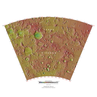
The Phaethontis quadrangle is one of a series of 30 quadrangle maps of Mars used by the United States Geological Survey (USGS) Astrogeology Research Program. The Phaethontis quadrangle is also referred to as MC-24.

<span class="mw-page-title-main">Thaumasia quadrangle</span> Map of Mars

The Thaumasia quadrangle is one of a series of 30 quadrangle maps of Mars used by the United States Geological Survey (USGS) Astrogeology Research Program. The Thaumasia quadrangle is also referred to as MC-25 . The name comes from Thaumas, the god of the clouds and celestial apparitions.

<span class="mw-page-title-main">Mare Australe quadrangle</span> Map of Mars

The Mare Australe quadrangle is one of a series of 30 quadrangle maps of Mars used by the United States Geological Survey (USGS) Astrogeology Research Program. The Mare Australe quadrangle is also referred to as MC-30. The quadrangle covers all the area of Mars south of 65°, including the South polar ice cap, and its surrounding area. The quadrangle's name derives from an older name for a feature that is now called Planum Australe, a large plain surrounding the polar cap. The Mars polar lander crash landed in this region.

<span class="mw-page-title-main">Lyot (Martian crater)</span> Crater on Mars

Lyot is a large peak ring crater in the Vastitas Borealis region of Mars, located at 50.8° north latitude and 330.7° west longitude within the Ismenius Lacus quadrangle. It is 236 km in diameter. Its name refers to Bernard Lyot, a French astronomer (1897–1952).

HiWish is a program created by NASA so that anyone can suggest a place for the HiRISE camera on the Mars Reconnaissance Orbiter to photograph. It was started in January 2010. In the first few months of the program 3000 people signed up to use HiRISE. The first images were released in April 2010. Over 12,000 suggestions were made by the public; suggestions were made for targets in each of the 30 quadrangles of Mars. Selected images released were used for three talks at the 16th Annual International Mars Society Convention. Below are some of the over 4,224 images that have been released from the HiWish program as of March 2016.

<span class="mw-page-title-main">Gullies on Mars</span> Incised networks of narrow channels and sediments on Mars

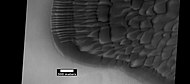
Martian gullies are small, incised networks of narrow channels and their associated downslope sediment deposits, found on the planet of Mars. They are named for their resemblance to terrestrial gullies. First discovered on images from Mars Global Surveyor, they occur on steep slopes, especially on the walls of craters. Usually, each gully has a dendritic alcove at its head, a fan-shaped apron at its base, and a single thread of incised channel linking the two, giving the whole gully an hourglass shape. They are estimated to be relatively young because they have few, if any craters. A subclass of gullies is also found cut into the faces of sand dunes, that are themselves considered to be quite young. Linear dune gullies are now considered recurrent seasonal features.

<span class="mw-page-title-main">Glaciers on Mars</span> Extraterrestrial bodies of ice

Glaciers, loosely defined as patches of currently or recently flowing ice, are thought to be present across large but restricted areas of the modern Martian surface, and are inferred to have been more widely distributed at times in the past. Lobate convex features on the surface known as viscous flow features and lobate debris aprons, which show the characteristics of non-Newtonian flow, are now almost unanimously regarded as true glaciers.

The common surface features of Mars include dark slope streaks, dust devil tracks, sand dunes, Medusae Fossae Formation, fretted terrain, layers, gullies, glaciers, scalloped topography, chaos terrain, possible ancient rivers, pedestal craters, brain terrain, and ring mold craters.

References

  1. Charlton T. Lewis, Charles Short, A Latin Dictionary, Oxford. Clarendon Press. 1879. ISBN   0-19-864201-6
  2. "Vastitas Borealis". Gazetteer of Planetary Nomenclature. USGS Astrogeology Science Center. Archived from the original on 23 April 2018. Retrieved 22 April 2021.
  3. "known as the North polar erg" Archived 30 August 2017 at the Wayback Machine at HiRISE project
  4. "Planetary Names: Vastitas, vastitates: Vastitas Borealis on Mars". planetarynames.wr.usgs.gov. Archived from the original on 18 April 2017. Retrieved 17 April 2017.
  5. USGS Planetary Nomenclature [ permanent dead link ] (click on the feature name for details)
  6. Andrews-Hanna, Jeffrey C.; Zuber, Maria T.; Banerdt, W. Bruce (1 June 2008). "The Borealis basin and the origin of the martian crustal dichotomy". Nature. 453 (7199): 1212–1215. Bibcode:2008Natur.453.1212A. doi:10.1038/nature07011. ISSN   0028-0836. PMID   18580944. S2CID   1981671.
  7. "NASA – NASA Spacecraft Reveal Largest Crater in Solar System". nasa.gov. Archived from the original on 22 November 2013. Retrieved 18 April 2017.
  8. "Water ice in crater at Martian north pole". European Space Agency. Archived from the original on 6 October 2012. Retrieved 4 August 2007.
  9. Lakdawalla, Emily (27 May 2008). "Phoenix Sol 2 press conference, in a nutshell". The Planetary Society weblog. Planetary Society. Archived from the original on 22 April 2014.
  10. "Mars lander aims for touchdown in 'Green Valley'". New Scientist Space. 11 April 2008. Archived from the original on 7 September 2012.
  11. Levy, J, J. Head, and D. Marchant. 2009. Thermal contraction crack polygons on Mars: Classification, distribution, and climate implications from HiRISE observations. Journal of Geographical Research: 114. p E01007
  12. "The Dirt on Mars Lander Soil Findings". space.com. 2 July 2009. Archived from the original on 26 January 2010. Retrieved 5 May 2018.
  13. 1 2 3 Whiteway, J. et al. 2009. Mars Water-Ice Clouds and Precipitation. Science: 325. p 68–70
  14. "JPL". Jet Propulsion Laboratory . Retrieved 11 August 2012.[ dead link ]
  15. Hecht, M. et al. 2009. Detection of Perchlorate and the Soluble Chemistry of Martian Soil at the Phoenix Lander Site. Science: 325. 64–67
  16. Boynton, W. et al. 2009. Evidence for Calcium Carbonate at the Mars Phoenix Landing Site. Science: 325. p 61–64
  17. Guest, J., P. Butterworth, and R. Greeley. 1977. Geological observations in the Cydonia region of Mars from Viking. J. Geophys. Res. 82. 4111–4120.
  18. Signs of Aeolian and Periglacial Activity at Vastitas Borealis (HiRISE Image ID: PSP_001481_2410) Archived 3 March 2016 at the Wayback Machine
  19. Murchie, S. et al. 2009. A synthesis of Martian aqueous mineralogy after 1 Mars year of observations from the Mars Reconnaissance Orbiter. Journal of Geophysical Research: 114.
  20. esa. "Breathtaking views of Deuteronilus Mensae on Mars". esa.int. Archived from the original on 18 October 2012. Retrieved 5 May 2018.
  21. Madeleine, J. et al. 2007. Exploring the northern mid-latitude glaciation with a general circulation model. In: Seventh International Conference on Mars. Abstract 3096.
  22. "ASC – Ficher introuvable – CSA – File not found". Archived from the original on 5 October 2011. Retrieved 22 July 2009.
  23. "CSA – News Release". Archived from the original on 5 July 2011. Retrieved 19 December 2010.
  24. Smith, P. et al. H2O at the Phoenix Landing Site. 2009. Science:325. p58-61
  25. Boynton, et al. 2009. Evidence for Calcium Carbonate at the Mars Phoenix Landing Site. Science. 325: 61–64

Further reading