Valley network (Mars)

Last updated
Branched valley network in Thaumasia quadrangle, as seen by Viking Orbiter. Field of view is roughly 200 km across. Branched Channels from Viking.jpg
Branched valley network in Thaumasia quadrangle, as seen by Viking Orbiter. Field of view is roughly 200 km across.

Valley networks are branching networks of valleys on Mars that superficially resemble terrestrial river drainage basins. [1] They are found mainly incised into the terrain of the martian southern highlands, and are typically - though not always - of Noachian age (approximately four billion years old). The individual valleys are typically less than 5 kilometers wide, though they may extend for up to hundreds or even thousands of kilometers across the martian surface.

Contents

The form, distribution, and implied evolution of the valley networks are of great importance for what they may tell us about the history of liquid water on the martian surface, and hence Mars' climate history. Some authors have argued that the properties of the networks demand that a hydrological cycle must have been active on ancient Mars, [2] though this remains contentious. [3] Objections chiefly arise from repeated results from models of martian paleoclimate suggesting high enough temperatures and pressures to sustain liquid water on the surface have not ever been possible on Mars. [4]

The advent of very high resolution images of the surface from the HiRISE, THEMIS and Context (CTX) satellite cameras as well as the Mars Orbital Laser Altimeter (MOLA) digital terrain models have drastically improved our understanding of the networks in the last decade.

Form

Part of a valley network near Warrego Valles, seen by THEMIS. Length of image is roughly 50 km. Channels near Warrego in Thaumasia.JPG
Part of a valley network near Warrego Valles, seen by THEMIS. Length of image is roughly 50 km.

The valleys of the networks are typically narrow (<0.5–4 km) and 50–200 m deep, with neither value changing consistently along their lengths. Their cross-sectional form tends to evolve from V-shaped in the headwaters to U-shaped in the lower reaches. The individual valleys form interconnected branching networks, typically less than 200 km long and draining into local topographic lows. [1] The form of the tributary valleys is commonly described as "stubby" or a similar term, implying short lengths away from the trunk streams and amphitheater-like terminations at their heads. [1] [5] Many authors have described the drainage density of the networks as typically much lower than would be seen on Earth, [6] [7] [8] though the extent to which this may be an artifact of image resolution, landscape degradation or observer bias has also been raised in the literature. [1] [2]

However, more recent imagery has also emphasized that the term "valley network" incorporates a large variety of different valley forms across a number of different scales in different martian geological settings. [2] Any branched valley system on a scale smaller than an outflow channel can be termed a valley network, probably incorporating a large variety of geomorphological formation processes. Some valley networks run for over 2000 km across the martian landscape. Some may change width downstream. Some have drainage densities which do match some terrestrial values. [9] Narrower, less deep valley networks are present, but probably are more rare than their larger equivalents. [1]

In most valley networks, later aeolian processes have deposited wind-blown sediments in the bottoms of the valleys, obscuring the nature of the channel which must have cut them. On Earth, a valley is a depression with a flat floor, across which migrates a channel, which carries the water discharge. Due to the later deposits on Mars, however, in almost all cases it is unclear whether the valley floors contain individual channel structures or whether they are fully inundated in flow events. Nanedi Valles is a rare example where a channel has been identified, [3] though new higher resolution imagery again continues to reveal more such structures with time. [10] This accounts for the preference in the literature for the term "valley network" rather than "channel network", though some work tends to confuse the two in interpretation of these structures. [2]

Distribution and age

Finer scale valley networks near Candor Chasma, seen by HiRISE (click to zoom). Field of view is roughly 3.5 km across. Surface the valleys are cut into appears to be eroding back. Candor Channels.jpg
Finer scale valley networks near Candor Chasma, seen by HiRISE (click to zoom). Field of view is roughly 3.5 km across. Surface the valleys are cut into appears to be eroding back.

Valley networks are very strongly concentrated in the cratered southern uplands of Mars. The Hesperian-age lava plains of the northern hemisphere are in general almost entirely undissected. However, there are significant numbers of exceptions to this generalization - in particular, many of the Hesperian and younger volcanoes carry networks, as well as several other areas. [1] These valleys also appear qualitatively "fresher" and less degraded than those in the highlands (e.g., Nanedi Vallis).

However, at finer scales than this the distribution of the valleys where present is highly patchy and discontinuous. Within the highlands, it is not unusual to find heavily dissected slopes immediately adjacent to almost entirely unmodified surfaces, both at valley and catchment scales. The valleys are also regionally clustered, with little dissection in Northwest Arabia and southwest and southeast of Hellas, but much in Terra Cimmeria and just south of the equator from 20°E to 180°E. They are also much more prominent on steeper slopes, [2] for example on crater rims, but again may only be present on one side of such a rim. [1]

Unfortunately, the generally small size of individual catchments and the relative narrowness of their constituent valleys means that dating the valley networks by conventional crater counting techniques is extremely difficult (though not impossible [11] ). The concentration of the valleys in the Noachian-age southern highlands and their sparsity on the northern Hesperian plains, circumstantially combined with independent estimates of a multi-order of magnitude decrease in global martian erosion rates at the end of the Noachian, [12] probably indicates that most of the networks were cut during this early interval. [1] However, the channels on Hesperian surfaces unambiguously demonstrate that valley-forming processes did continue at least in some locations at least some of the time after the Noachian. Some crater counting evidence even suggests some highland networks may have formed in the Amazonian. [11]

Formation and implications for Martian climate history

The Eberswalde delta, seen by MGS. Note the meanders with cutoffs, now seen in inverted relief. Eberswalde. Delta.jpg
The Eberswalde delta, seen by MGS. Note the meanders with cutoffs, now seen in inverted relief.

Mechanisms and implied environments for the formation of the valleys remain contentious. Processes as diverse as glaciation, mass wasting, faulting, and erosion by CO2, wind and lava have all been invoked at some point in the formation of some networks, and may play important roles locally in some regions on Mars. Most authors however agree that liquid water must have played a role in the formation of the bulk of the valleys, largely on the basis of both the known widespread distribution of ice on Mars and also the physical properties of liquid water (e.g., viscosity) that almost uniquely allow it to flow thousands of kilometers downhill as streams. [1] Channel features on what are interpreted as eroded deltas at the foot of some networks (e.g., in Eberswalde crater) are also uniquely associated with formation by flowing water - for example, meandering, sinuous channels with meander cutoffs, which have internally consistent hydraulic geometries corresponding very closely to what would be expected in fluvial channels on Earth. [13] Independent lines of evidence also suggest the existence of liquid water at or very near the surface at various times in martian history, for example, evaporites at Meridiani Planum and pervasive aqueous alteration of rocks in the Columbia Hills, both investigated by the Mars Exploration Rovers.

Beyond this, there are several different scenarios that have been advanced to account for the form and distribution in both space and time of the valleys. Each has its own set of implications regarding the paleoclimate of Mars at the time of formation of the networks. Some of these are summarized below. It is also worth emphasizing that, as on Earth, different formation mechanisms are likely to operate at different times and places on the surface of Mars.

In August 2020 scientists reported that valley networks in the southern highlands of Mars may have been formed mostly under glaciers, not free-flowing rivers of water, indicating that early Mars was colder than thought and that extensive glaciation likely occurred in its past. [14] [15] [16]

1. Business as usual, groundwater under ice: Cold, dry Mars

This scenario seeks to describe the formation of the valley networks without appeal to conditions or processes different from those already known to exist on Mars today. Modeling indicates that seeps of groundwater could occur on the surface even under modern conditions, but will freeze very quickly. However, under this suggestion ice cover could insulate the water flowing beneath it well enough to allow long-distance transport (and associated erosion), much like a lava tube insulates the molten lava inside it. [17]

The valleys typically have many features that on Earth are commonly (though not exclusively [18] ) associated with groundwater sapping - for instance, amphitheater-like headwalls, constant valley width downstream, flat or U-shaped floors and steep walls. [19] However, without some recharge mechanism for the putative aquifers producing this seepage, i.e., a hydrologic cycle of some kind, it is extremely unlikely that enough water could seep to cut all of the valleys formed in the Noachian. In spite of this, this basic model may remain useful in understanding the more limited valleys formed later in the Hesperian and Amazonian. [1]

2. Groundwater sources, hydrological cycle: Cold, wet Mars

These models expand upon the cold, dry Mars model by envisioning mechanisms whereby subsurface aquifers providing groundwater might be recharged in early Mars history. They thus require a sustained water cycle of some sort on the long term in the Noachian, but do not explicitly require that this water be liquid or fall as precipitation. This means Mars need not be warm (i.e., above freezing) in its early history, in accordance with current climate models. [4]

Global groundwater circulation

It has been proposed [20] that the aquifers could be recharged on geological time scales by a sequence of sublimation of the frozen seeps, atmospheric circulation of the vapor to the southern polar ice cap, redeposition of this onto the cap, basal melting under the ice mass, and groundwater circulation on a global scale. This mechanism is appealing as it requires little conjecture about radically different past climate, and fits well with independent theories on the origins of the martian outflow channels at chaos terrains as major aquifer breaches. However, the hydrostatic head supplied by this mechanism could not feed the numerous channels at elevations greater than the base of the southern polar cap. [21]

Local groundwater circulation

A related model suggests that locally generated heat could produce local scale groundwater seepage and recharge, either by intrusive volcanism [22] or impact heating. [23] [24] However, this version struggles to explain the longer, larger valley networks - if water flows hundreds or thousands of kilometers away from the heat source, ground will again be frozen and recharge will not be possible once again. [1]

3. Full active hydrological cycle: Warm, wet Mars

Many of the Noachian valley networks have features strongly indicative of an origin from distributed precipitation: branched networks, valleys starting at narrow crests, V-shaped cross profiles, diffusional behavior of hillslopes. Conversely, using only geomorphic evidence, it is very challenging to build a strong argument against origin by precipitation. [2] Precipitation also provides a straightforward recharge mechanism for subsurface aquifers, which doubtlessly do exist and are important in some cases (as on Earth). This precipitation may have occurred as rain or snow (with subsequent melt on the ground), but either demands a significantly more humid, and thus warmer and thicker, atmosphere than presently exists. A warmer, wetter Noachian is also supported by independent observations of rock weathering rates, Noachian-age crater lakes, and Noachian geology at the lander sites.

The chief difficulty with this model is that Martian climate simulations have difficulty reliably simulating a warm, wet Noachian, largely due to the distance between the Sun and Mars compared to the Earth, and the inferred weaker Sun in the early solar system. [4] Furthermore, a CO2-H2O greenhouse atmosphere to warm the climate should have left extensive deposits of carbonate rocks, which have not been found. Problems also exist with sustaining such an atmosphere for long enough to allow the valleys to form, as the unweathered basalts so prevalent on Mars should form extremely effective carbon sinks, especially if the surface is wet, [25] and continuing impacts from space in Mars' early history should quickly strip any atmosphere away. [26]

Solutions to this apparent contradiction may include exotic mechanisms that do not require a sustained CO2-H2O greenhouse, such as episodic heating due to volcanism or impacts. Other possibilities (other than misinterpretation of the geology and geomorphology) are defects in the physics of, or boundary conditions for, the climate models - a stronger Sun than current theory predicts, defective assumptions about trace (but powerful) greenhouse gases, or failings in the parameterization of CO2 clouds. [1]

However, it is possible that additional trace gases, together with CO2, could have solved this paradox. Ramirez et al.(2014) [27] had shown that a CO2-H2 greenhouse would be strong enough to produce the above-freezing temperatures necessary for valley formation. This CO2-H2 greenhouse has been subsequently found to be even more effective than originally demonstrated in Ramirez et al. (2014), [28] with warm solutions possible at hydrogen concentrations and CO2 pressures as low as 1% and 0.55 bar, respectively. [29]

Related Research Articles

<span class="mw-page-title-main">Holden (Martian crater)</span> Martian crater

Holden is a 140 km wide crater situated within the Margaritifer Sinus quadrangle (MC-19) region of the planet Mars, located with the southern highlands. It is named after American astronomer Edward Singleton Holden. It is part of the Uzboi-Landon-Morava (ULM) system.

<span class="mw-page-title-main">Newton (Martian crater)</span> Crater on Mars

Newton is a large crater on Mars, with a diameter close to 300 km. It is located south of the planet's equator in the heavily cratered highlands of Terra Sirenum in the Phaethontis quadrangle. The crater was named in 1973 by the International Astronomical Union (IAU) Working Group for Planetary System Nomenclature (WGPSN) in honor of British physicist Sir Isaac Newton.

<span class="mw-page-title-main">Mare Acidalium quadrangle</span> Map of Mars

The Mare Acidalium quadrangle is one of a series of 30 quadrangle maps of Mars used by the United States Geological Survey (USGS) Astrogeology Research Program. The quadrangle is located in the northeastern portion of Mars’ western hemisphere and covers 300° to 360° east longitude and 30° to 65° north latitude. The quadrangle uses a Lambert conformal conic projection at a nominal scale of 1:5,000,000 (1:5M). The Mare Acidalium quadrangle is also referred to as MC-4.

<span class="mw-page-title-main">Iapygia quadrangle</span> Map of Mars

The Iapygia quadrangle is one of a series of 30 quadrangle maps of Mars used by the United States Geological Survey (USGS) Astrogeology Research Program. The Iapygia quadrangle is also referred to as MC-21. It was named after the heel of the boot of Italy. That name was given by the Greeks It is part of a region of Italy named Apulia. The name Iapygia was approved in 1958.

<span class="mw-page-title-main">Mare Tyrrhenum quadrangle</span> Part of the surface of Mars

The Mare Tyrrhenum quadrangle is one of a series of 30 quadrangle maps of Mars used by the United States Geological Survey (USGS) Astrogeology Research Program. This quadrangle is also referred to as MC-22. It contains parts of the regions Tyrrhena Terra, Hesperia Planum, and Terra Cimmeria.

<span class="mw-page-title-main">Phaethontis quadrangle</span> Map of Mars

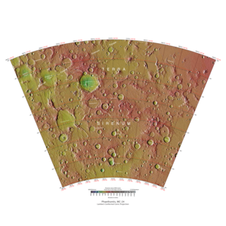
The Phaethontis quadrangle is one of a series of 30 quadrangle maps of Mars used by the United States Geological Survey (USGS) Astrogeology Research Program. The Phaethontis quadrangle is also referred to as MC-24.

<span class="mw-page-title-main">Thaumasia quadrangle</span> Map of Mars

The Thaumasia quadrangle is one of a series of 30 quadrangle maps of Mars used by the United States Geological Survey (USGS) Astrogeology Research Program. The Thaumasia quadrangle is also referred to as MC-25 . The name comes from Thaumas, the god of the clouds and celestial apparitions.

<span class="mw-page-title-main">Mare Australe quadrangle</span> Map of Mars

The Mare Australe quadrangle is one of a series of 30 quadrangle maps of Mars used by the United States Geological Survey (USGS) Astrogeology Research Program. The Mare Australe quadrangle is also referred to as MC-30. The quadrangle covers all the area of Mars south of 65°, including the South polar ice cap, and its surrounding area. The quadrangle's name derives from an older name for a feature that is now called Planum Australe, a large plain surrounding the polar cap. The Mars polar lander crash landed in this region.

<span class="mw-page-title-main">Gorgonum Chaos</span> Chaos on Mars

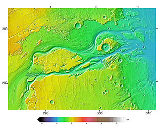
Gorgonum Chaos is a set of canyons in the Phaethontis quadrangle of Mars. It is located at 37.5° south latitude and 170.9° west longitude. Its name comes from an albedo feature at 24S, 154W. Some of the first gullies on Mars were found in Gorgonum Chaos. It is generally believed that it once contained a lake. Other nearby features are Sirenum Fossae, Maadim Vallis, Ariadnes Colles, and Atlantis Chaos. Some of the surfaces in the region are formed from the Electris deposits.

<span class="mw-page-title-main">Outflow channels</span> Long, wide swathes of scoured ground on Mars

Outflow channels are extremely long, wide swathes of scoured ground on Mars. They extend many hundreds of kilometers in length and are typically greater than one kilometer in width. They are thought to have been carved by huge outburst floods.

<span class="mw-page-title-main">Enipeus Vallis</span> Vallis on Mars

Enipeus Vallis is a valley in the northern hemisphere of the planet Mars. It is centered at lat. 37°N, long. 267°E in the Arcadia quadrangle (MC-3) between the large volcano Alba Mons and the Tempe Terra plateau. The valley follows a gently sinuous, north-south path for a distance of about 357 km (222 mi). It is likely an ancient watercourse that formed during the early Hesperian period, around 3.7 billion years ago.

Bouguer Crater is an impact crater in the Sinus Sabaeus quadrangle of Mars, located at 18.7° S and 332.8° W It is 107 km in diameter and was named after Pierre Bouguer, French physicist-hydrographer (1698–1758).

<span class="mw-page-title-main">Noachian</span> Geological system and early time period of Mars

The Noachian is a geologic system and early time period on the planet Mars characterized by high rates of meteorite and asteroid impacts and the possible presence of abundant surface water. The absolute age of the Noachian period is uncertain but probably corresponds to the lunar Pre-Nectarian to Early Imbrian periods of 4100 to 3700 million years ago, during the interval known as the Late Heavy Bombardment. Many of the large impact basins on the Moon and Mars formed at this time. The Noachian Period is roughly equivalent to the Earth's Hadean and early Archean eons when the first life forms likely arose.

<span class="mw-page-title-main">Hesperian</span> Era of Mars geologic history

The Hesperian is a geologic system and time period on the planet Mars characterized by widespread volcanic activity and catastrophic flooding that carved immense outflow channels across the surface. The Hesperian is an intermediate and transitional period of Martian history. During the Hesperian, Mars changed from the wetter and perhaps warmer world of the Noachian to the dry, cold, and dusty planet seen today. The absolute age of the Hesperian Period is uncertain. The beginning of the period followed the end of the Late Heavy Bombardment and probably corresponds to the start of the lunar Late Imbrian period, around 3700 million years ago (Mya). The end of the Hesperian Period is much more uncertain and could range anywhere from 3200 to 2000 Mya, with 3000 Mya being frequently cited. The Hesperian Period is roughly coincident with the Earth's early Archean Eon.

Chaos terrain on Mars is distinctive; nothing on Earth compares to it. Chaos terrain generally consists of irregular groups of large blocks, some tens of kilometers across and a hundred or more meters high. The tilted and flat topped blocks form depressions hundreds of metres deep. A chaotic region can be recognized by a rat's nest of mesas, buttes, and hills, chopped through with valleys which in places look almost patterned. Some parts of this chaotic area have not collapsed completely—they are still formed into large mesas, so they may still contain water ice. Chaos regions formed long ago. By counting craters and by studying the valleys' relations with other geological features, scientists have concluded the channels formed 2.0 to 3.8 billion years ago.

<span class="mw-page-title-main">Groundwater on Mars</span> Water held in permeable ground

During past ages, there was rain and snow on Mars; especially in the Noachian and early Hesperian epochs. Some moisture entered the ground and formed aquifers. That is, the water went into the ground, seeped down until it reached a formation that would not allow it to penetrate further. Water then accumulated forming a saturated layer. Deep aquifers may still exist.

<span class="mw-page-title-main">Geological history of Mars</span> Physical evolution of the planet Mars

The geological history of Mars follows the physical evolution of Mars as substantiated by observations, indirect and direct measurements, and various inference techniques. Methods dating back to 17th-century techniques developed by Nicholas Steno, including the so-called law of superposition and stratigraphy, used to estimate the geological histories of Earth and the Moon, are being actively applied to the data available from several Martian observational and measurement resources. These include landers, orbiting platforms, Earth-based observations, and Martian meteorites.

<span class="mw-page-title-main">Peace Vallis</span> Martian valley

Peace Vallis is an ancient stream valley on the northern rim of Gale Crater on the planet Mars. It is notable for its associated alluvial fan which lies near the Mars Science Laboratory Curiosity landing site. The valley and alluvial fan provide evidence for geologically recent (Amazonian-aged) fluvial activity and sustained water flow on Mars. Recent high-resolution orbital images of Peace Vallis and its watershed also suggest that at least one glacial episode affected Gale crater. All of this evidence has implications for the history of water on Mars and the planet's long-term habitability. Understanding Peace Vallis and its fan also provides geologic context for the rocks observed on the ground by the Curiosity rover.

<span class="mw-page-title-main">Lakes on Mars</span> Overview of the presence of lakes on Mars

In summer 1965, the first close-up images from Mars showed a cratered desert with no signs of water. However, over the decades, as more parts of the planet were imaged with better cameras on more sophisticated satellites, Mars showed evidence of past river valleys, lakes and present ice in glaciers and in the ground. It was discovered that the climate of Mars displays huge changes over geologic time because its axis is not stabilized by a large moon, as Earth's is. Also, some researchers maintain that surface liquid water could have existed for periods of time due to geothermal effects, chemical composition or asteroid impacts. This article describes some of the places that could have held large lakes.

<span class="mw-page-title-main">Dorsa Argentea Formation</span>

The Dorsa Argentea Formation (DAF) is thought to be a large system of eskers that were under an ancient ice cap in the south polar region of Mars. The ancient ice cap was at least twice the size of the present ice cap and may have been 1500–2000 meters thick. Later research suggests that the area of this polar ice sheet is believed to have covered about 1.5 million square kilometers, roughly twice the size of France or the American state of Texas. This group of ridges extends from 270–100 E and 70–90 S, around the south pole of Mars. It sits under the Late Amazonian South Polar Layered Deposits (SPLD), in the Mare Australe quadrangle.

References

  1. 1 2 3 4 5 6 7 8 9 10 11 12 Carr, M.H. (2006), The Surface of Mars. Cambridge Planetary Science Series, Cambridge University Press.
  2. 1 2 3 4 5 6 Craddock, R.A., and Howard, A.D. (2002), The case for rainfall on a warm, wet early Mars, J. Geophys. Res., 107(E11), doi : 10.1029/2001JE001505
  3. 1 2 Malin, M.C., and Carr, M.H. (1999), Groundwater formation of martian valleys, Nature, 397, 589-592
  4. 1 2 3 Haberle, R.M. (1998), Early Climate Models, J. Geophys. Res., 103(E12),28467-79.
  5. Baker, V. R., and Partridge, J. (1986), Small martian valleys: Pristine and degraded morphology, J. Geophys. Res., 91, 3561–3572
  6. Pieri, D. (1976), Distribution of small channels on the martian surface, Icarus, 27, 25– 50
  7. Brakenridge, G. R., H. E. Newsom, and Baker, V.R. (1985), Ancient hot springs on Mars: Origins and paleoenvironmental significance of small martian valleys, Geology, 13, 859–862
  8. Clifford, S. M. (1993), A model for the hydrologic and climatic behavior of water on Mars, J. Geophys. Res., 98, 10,973–11,016
  9. Hynek, B.M., and Phillips, R.J. (2001), Evidence of extensive denudation of the martian highlands, Geology, 29, 407-10
  10. Jaumann, R. (2005), Martian valley networks and associated fluvial features as seen by the Mars Express High Resolution Camera (HRSC), LPSC XXXVI, Abstract 1815
  11. 1 2 Dohm, J.M., and Scott, D.H. (1993), Relation between ages and elevation of martian channels (abstract), Lunar Planet. Sci., XXIV, 407– 408
  12. Golombek, M.P., and Bridges, N.T. (2000), Erosion rates on Mars and implications for climate change: constraints from the Pathfinder landing site, J. Geophys. Res., 105(E1), 1841-1853
  13. Irwin, R.P., and Grant, J., submitted manuscript
  14. "Early Mars was covered in ice sheets, not flowing rivers: study". phys.org. Retrieved 6 September 2020.
  15. Crane, Leah. "Ancient valleys on Mars may have been carved by glaciers". New Scientist. Retrieved 6 September 2020.
  16. Grau Galofre, Anna; Jellinek, A. Mark; Osinski, Gordon R. (3 August 2020). "Valley formation on early Mars by subglacial and fluvial erosion". Nature Geoscience. 13 (10): 663–668. Bibcode:2020NatGe..13..663G. doi:10.1038/s41561-020-0618-x. ISSN   1752-0908. S2CID   220939044 . Retrieved 6 September 2020.
  17. Squyres, S.W., and Kasting, J.F. (1994), Early Mars: How warm and how wet?, Science, 265, 744-8.
  18. Lamb, M.P, Howard, A.D., Johnson, J., Whipple, K.X., Dietrich, W.E., and Perron, T. (2006), Can springs cut canyons into rock?, J. Geophys. Res., 111, E07002, doi : 10.1029/2005JE002663
  19. Sharp, R.P, and Malin, M.C. (1975), Channels on Mars, Geol. Soc. Am. Bull., 86, 593-609.
  20. Clifford, S.M. (1993), A model for the hydrologic and climatic behavior of water on Mars, J. Geophys. Res., 98, 10973-1016
  21. Carr, M.H. (2002), Elevation of water-worn features on Mars: Implications for circulation of groundwater, J. Geophys. Res., 107(E12), 5131, doi : 10.1029/2002JE001963.
  22. Gulick, V.C. (1998), Magmatic intrusions and a hydrothermal origin of fluvial valleys on Mars, J. Geophys. Res., 103, 19365-87.
  23. Newsome, H.E. (1980), Hydrothermal alteration of impact melt sheets with implications for Mars, Icarus, 44, 207-16.
  24. Salese, F., G. Di Achille, A. Neesemann, G. G. Ori, and E. Hauber (2016), Hydrological and sedimentary analyses of well-preserved paleofluvial-paleolacustrine systems at Moa Valles, Mars, J. Geophys. Res. Planets, 121, 194–232, doi:10.1002/2015JE004891
  25. Pollack, J.B., Kasting, J.F., Richardson, S.M., and Poliakoff, K. (1987), The case for a warm wet climate on early Mars, Icarus, 71, 203-24.
  26. Carr, M.H. (1999), Retention of an atmosphere on early Mars, J. Geophys. Res., 104, 21897-909.
  27. Ramirez, R. M., Kopparapu, R., Zugger, M. E., Robinson, T. D., Freedman, R., & Kasting, J. F. (2014). Warming early Mars with CO2 and H
    2
    . Nature Geoscience, 7(1), 59-63.
  28. Wordsworth, R., Kalugina, Y., Lokshtanov, S., Vigasin, A., Ehlmann, B., Head, J., ... & Wang, H. (2017). Transient reducing greenhouse warming on early Mars. Geophysical Research Letters, 44(2), 665-671
  29. Ramirez, R.M. (2017) A warmer and wetter solution for early Mars and the challenges with transient warming. Icarus, 297, 71-82