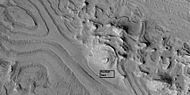
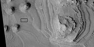
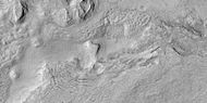
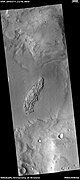
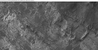
The Memnonia quadrangle is one of a series of 30 quadrangle maps of Mars used by the United States Geological Survey (USGS) Astrogeology Research Program. The Memnonia quadrangle is also referred to as MC-16.

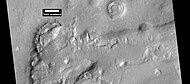
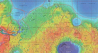
Terra Sirenum is a large region in the southern hemisphere of the planet Mars. It is centered at 39.7°S 150°W and covers 3900 km at its broadest extent. It covers latitudes 10 to 70 South and longitudes 110 to 180 W. Terra Sirenum is an upland area notable for massive cratering including the large Newton Crater. Terra Sirenum is in the Phaethontis quadrangle and the Memnonia quadrangle of Mars. A low area in Terra Sirenum is believed to have once held a lake that eventually drained through Ma'adim Vallis.

Tempe Terra is a heavily cratered highland region in the northern hemisphere of the planet Mars. Located at the northeastern edge of the Tharsis volcanic province, Tempe Terra is notable for its high degree of crustal fracturing and deformation. The region also contains many small shield volcanoes, lava flows, and other volcanic structures.
Tyrrhena Terra is a large area on Mars, centered south of the Martian equator and immediately northeast of the Hellas basin. Its coordinates are 14.8°S 90°E, and it covers 2300 km at its broadest extent. It was named for a classic albedo feature of the planet and is in the Mare Tyrrhenum quadrangle of Mars. Tyrrhena Terra is typical of the southern Martian terrae, with heavily cratered highlands and other rugged terrain. It contains the large volcano Tyrrhena Patera, one of the oldest volcanoes on Mars. Its largest crater is Herschel. Licus Vallis and the Ausonia Montes are other major features in the region. Some channels and dunes are visible in Tyrrhena Terra, as shown in the images below.
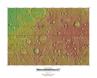
Terra Sabaea is a large area on Mars. Its coordinates are 2°N42°E and it covers 4,700 kilometres (2,900 mi) at its broadest extent. It was named in 1979 after a classic albedo feature on the planet. Terra Sabaea is fairly large and parts of it are found in five quadrangles: Arabia quadrangle, Syrtis Major quadrangle, Iapygia quadrangle, Ismenius Lacus quadrangle, and Sinus Sabaeus quadrangle.

The Noachis quadrangle is one of a series of 30 quadrangle maps of Mars used by the United States Geological Survey (USGS) Astrogeology Research Program. The Noachis quadrangle is also referred to as MC-27.

The Ismenius Lacus quadrangle is one of a series of 30 quadrangle maps of Mars used by the United States Geological Survey (USGS) Astrogeology Research Program. The quadrangle is located in the northwestern portion of Mars' eastern hemisphere and covers 0° to 60° east longitude and 30° to 65° north latitude. The quadrangle uses a Lambert conformal conic projection at a nominal scale of 1:5,000,000 (1:5M). The Ismenius Lacus quadrangle is also referred to as MC-5. The southern and northern borders of the Ismenius Lacus quadrangle are approximately 3,065 km (1,905 mi) and 1,500 km (930 mi) wide, respectively. The north-to-south distance is about 2,050 km (1,270 mi). The quadrangle covers an approximate area of 4.9 million square km, or a little over 3% of Mars' surface area. The Ismenius Lacus quadrangle contains parts of Acidalia Planitia, Arabia Terra, Vastitas Borealis, and Terra Sabaea.

The Casius quadrangle is one of a series of 30 quadrangle maps of Mars used by the United States Geological Survey (USGS) Astrogeology Research Program. The quadrangle is located in the north-central portion of Mars' eastern hemisphere and covers 60° to 120° east longitude and 30° to 65° north latitude. The quadrangle uses a Lambert conformal conic projection at a nominal scale of 1:5,000,000 (1:5M). The Casius quadrangle is also referred to as MC-6. Casius quadrangle contains part of Utopia Planitia and a small part of Terra Sabaea. The southern and northern borders of the Casius quadrangle are approximately 3,065 km and 1,500 km wide, respectively. The north to south distance is about 2,050 km. The quadrangle covers an approximate area of 4.9 million square km, or a little over 3% of Mars' surface area.

The Arcadia quadrangle is one of a series of 30 quadrangle maps of Mars used by the United States Geological Survey (USGS) Astrogeology Research Program. The quadrangle is located in the north-central portion of Mars’ western hemisphere and covers 240° to 300° east longitude and 30° to 65° north latitude. The quadrangle uses a Lambert conformal conic projection at a nominal scale of 1:5,000,000 (1:5M). The Arcadia quadrangle is also referred to as MC-3. The name comes from a mountainous region in southern Greece. It was adopted by IAU, in 1958.

The Mare Acidalium quadrangle is one of a series of 30 quadrangle maps of Mars used by the United States Geological Survey (USGS) Astrogeology Research Program. The quadrangle is located in the northeastern portion of Mars' western hemisphere and covers 300° to 360° east longitude and 30° to 65° north latitude. The quadrangle uses a Lambert conformal conic projection at a nominal scale of 1:5,000,000 (1:5M). The Mare Acidalium quadrangle is also referred to as MC-4.

The Arabia quadrangle is one of a series of 30 quadrangle maps of Mars used by the United States Geological Survey (USGS) Astrogeology Research Program. The Arabia quadrangle is also referred to as MC-12.
The Sinus Sabaeus quadrangle is one of a series of 30 quadrangle maps of Mars used by the United States Geological Survey (USGS) Astrogeology Research Program. It is also referred to as MC-20 . The Sinus Sabaeus quadrangle covers the area from 315° to 360° west longitude and 0° to 30° degrees south latitude on Mars. It contains Schiaparelli, a large, easily visible crater that sits close to the equator. The Sinus Sabaeus quadrangle contains parts of Noachis Terra and Terra Sabaea.

The Iapygia quadrangle is one of a series of 30 quadrangle maps of Mars used by the United States Geological Survey (USGS) Astrogeology Research Program. The Iapygia quadrangle is also referred to as MC-21. It was named after the heel of the boot of Italy. That name was given by the Greeks It is part of a region of Italy named Apulia. The name Iapygia was approved in 1958.

The Mare Tyrrhenum quadrangle is one of a series of 30 quadrangle maps of Mars used by the United States Geological Survey (USGS) Astrogeology Research Program. This quadrangle is also referred to as MC-22. It contains parts of the regions Tyrrhena Terra, Hesperia Planum, and Terra Cimmeria.

The Margaritifer Sinus quadrangle is one of a series of 30 quadrangle maps of Mars used by the United States Geological Survey (USGS) Astrogeology Research Program. The Margaritifer Sinus quadrangle is also referred to as MC-19. The Margaritifer Sinus quadrangle covers the area from 0° to 45° west longitude and 0° to 30° south latitude on Mars. Margaritifer Sinus quadrangle contains Margaritifer Terra and parts of Xanthe Terra, Noachis Terra, Arabia Terra, and Meridiani Planum.
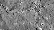
Fretted terrain is a type of surface feature common to certain areas of Mars and was discovered in Mariner 9 images. It lies between two different types of terrain. The surface of Mars can be divided into two parts: low, young, uncratered plains that cover most of the northern hemisphere, and high-standing, old, heavily cratered areas that cover the southern and a small part of the northern hemisphere. Between these two zones is a region called the Martian dichotomy and parts of it contain fretted terrain. This terrain contains a complicated mix of cliffs, mesas, buttes, and straight-walled and sinuous canyons. It contains smooth, flat lowlands along with steep cliffs. The scarps or cliffs are usually 1 to 2 km high. Channels in the area have wide, flat floors and steep walls. Fretted terrain shows up in northern Arabia, between latitudes 30°N and 50°N and longitudes 270°W and 360°W, and in Aeolis Mensae, between 10 N and 10 S latitude and 240 W and 210 W longitude. Two good examples of fretted terrain are Deuteronilus Mensae and Protonilus Mensae.
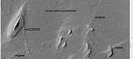
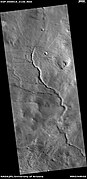
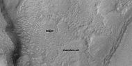
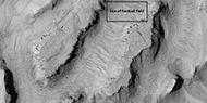
HiWish is a program created by NASA so that anyone can suggest a place for the HiRISE camera on the Mars Reconnaissance Orbiter to photograph. It was started in January 2010. In the first few months of the program 3000 people signed up to use HiRISE. The first images were released in April 2010. Over 12,000 suggestions were made by the public; suggestions were made for targets in each of the 30 quadrangles of Mars. Selected images released were used for three talks at the 16th Annual International Mars Society Convention. Below are some of the over 4,224 images that have been released from the HiWish program as of March 2016.

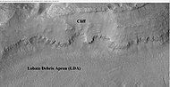
Glaciers, loosely defined as patches of currently or recently flowing ice, are thought to be present across large but restricted areas of the modern Martian surface, and are inferred to have been more widely distributed at times in the past. Lobate convex features on the surface known as viscous flow features and lobate debris aprons, which show the characteristics of non-Newtonian flow, are now almost unanimously regarded as true glaciers.
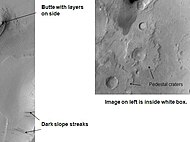
The common surface features of Mars include dark slope streaks, dust devil tracks, sand dunes, Medusae Fossae Formation, fretted terrain, layers, gullies, glaciers, scalloped topography, chaos terrain, possible ancient rivers, pedestal craters, brain terrain, and ring mold craters.

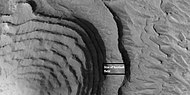
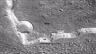
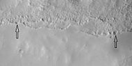
Brain terrain, also called knobs-brain coral and brain coral terrain, is a feature of the Martian surface, consisting of complex ridges found on lobate debris aprons, lineated valley fill and concentric crater fill. It is so named because it suggests the ridges on the surface of the human brain. Wide ridges are called closed-cell brain terrain, and the less common narrow ridges are called open-cell brain terrain. It is thought that the wide closed-cell terrain contains a core of ice, and when the ice disappears the center of the wide ridge collapses to produce the narrow ridges of the open-cell brain terrain. Shadow measurements from HiRISE indicate the ridges are 4-5 meters high. Brain terrain has been observed to form from what has been called an "Upper Plains Unit." The process begins with the formation of stress cracks. The upper plains unit fell from the sky as snow and as ice coated dust.