Groundwater on Mars

Last updated

The preservation and cementation of aeolian dune stratigraphy in Burns Cliff in Endurance Crater are thought to have been controlled by flow of shallow groundwater. Burns cliff.jpg
The preservation and cementation of aeolian dune stratigraphy in Burns Cliff in Endurance Crater are thought to have been controlled by flow of shallow groundwater.

Rain and snow was a regular occurrence on Mars in the past; especially in the Noachian and early Hesperian epochs. [2] [3] [4] [5] [6] [7] Water was theorized to seep into the ground until it reached a formation that would not allow it to penetrate further (such a layer is called an aquitard and is believed to be impermeable). Water then accumulated forming a saturated layer. Deep aquifers may still exist. [8]

Contents

Overviews

Researchers have found that Mars had a planet-wide groundwater system and several prominent features on the planet have been produced by the action of groundwater. [9] [10] When water rose to the surface or near the surface, various minerals were deposited and sediments became cemented together. Some of the minerals were sulfates that were probably produced when water dissolved sulfur from underground rocks, and then became oxidized when it came into contact with the air. [11] [12] [13] While traveling through the aquifer, the water passed through igneous rock basalt, which would have contained sulfur.

In an aquifer, water occupies open space (pore space) that lies between rock particles. This layer would spread out, eventually coming to be under most of the Martian surface. The top of this layer is called the water table. Calculations show that the water table on Mars was for a time 600 meters below the surface. [14] [15]

The InSight lander uncovered in September 2019 unexplained magnetic pulses, and magnetic oscillations consistent with an existing planet-wide reservoir of liquid water deep underground. [8]

Researchers have concluded that Gale Crater has experienced many episodes of groundwater surge with changes in the groundwater chemistry. These chemical changes would support life. [16] [17] [18] [19] [20] [21]

Layered terrain

Layers may be formed by groundwater rising up depositing minerals and cementing sediments. The hardened layers are consequently more protected from erosion. This process may occur instead of layers forming under lakes. Groundwaterseries8final.jpg
Layers may be formed by groundwater rising up depositing minerals and cementing sediments. The hardened layers are consequently more protected from erosion. This process may occur instead of layers forming under lakes.

Some locations on the Red Planet show groups of layered rocks. [22] [23] Rock layers are present under the resistant caps of pedestal craters, on the floors of many large impact craters, and in the area called Arabia. [24] [25] In some places the layers are arranged into regular patterns. [26] [27] It has been suggested that the layers were put into place by volcanoes, the wind, or by being at the bottom of a lake or sea. Calculations and simulations show that groundwater carrying dissolved minerals would surface in the same locations that have abundant rock layers. According to these ideas, deep canyons and large craters would receive water coming from the ground. Many craters in the Arabia area of Mars contain groups of layers. Some of these layers may have resulted from climate change.

The tilt of the rotational axis of Mars has repeatedly changed in the past. Some changes are large. Because of these variations of climate, at times the atmosphere of Mars would have been much thicker and contained more moisture. The amount of atmospheric dust also has increased and decreased. It is believed that these frequent changes helped to deposit material in craters and other low places. The rising of mineral-rich ground water cemented these materials. The model also predicts that after a crater is full of layered rocks, additional layers will be laid down in the area around the crater. So, the model predicts that layers may also have formed in intercrater regions; layers in these regions have been observed.

Layers can be hardened by the action of groundwater. Martian ground water probably moved hundreds of kilometers, and in the process it dissolved many minerals from the rock it passed through. When ground water surfaces in low areas containing sediments, water evaporates in the thin atmosphere and leaves behind minerals as deposits and/or cementing agents. Consequently, layers of dust could not later easily erode away since they were cemented together. On Earth, mineral-rich waters often evaporate forming large deposits of various types of salts and other minerals. Sometimes water flows through Earth's aquifers, and then evaporates at the surface just as is hypothesized for Mars. One location this occurs on Earth is the Great Artesian Basin of Australia. [28] On Earth the hardness of many sedimentary rocks, like sandstone, is largely due to the cement that was put in place as water passed through.

In February 2019, European scientists published geological evidence of an ancient planet-wide groundwater system that was, arguably, connected to a putative vast ocean. [29] [30]

Layers in Crommelin crater

Layers in Danielson crater

Inverted terrain

Many areas on Mars show inverted relief. In those places, former stream channels are displayed as raised beds, instead of stream valleys. Raised beds form when old stream channels become filled with material that is resistant to erosion. After later erosion removes surrounding soft materials, more resistant materials that were deposited in the stream bed are left behind. Lava is one substance that can flow down valleys and produce such inverted terrain. However, fairly loose materials can get quite hard and erosion resistant when cemented by minerals. These minerals can come from groundwater. It is thought that a low point, like a valley focuses groundflow, so more water and cements move into it, and this results in a greater degree of cementation. [9]

Terrain inversion can also happen without cementation by groundwater, however. If a surface is being eroded by wind, the necessary contrast in erodibility can arise simply from variations in grain size of loose sediments. Since wind can carry away sand but not cobbles, for example, a channel bed rich in cobbles could form an inverted ridge if it was originally surrounded by much finer sediments, even if the sediments were not cemented. This effect has been invoked for channels in Saheki crater. [31]

Places on Mars that contain layers in the bottoms of craters often also have inverted terrain.

Evidence for groundwater upwelling

Spacecraft sent to Mars provided a wealth of evidence for groundwater being a major cause of many rock layers on the planet. The Opportunity Rover studied some areas with sophisticated instruments. Opportunity’s observations showed that groundwater repeatedly had risen to the surface. Evidence for water coming to the surface a number of times include hematite concretions (called "blue berries"), cementation of sediments, alteration of sediments, and clasts or skeletons of formed crystals. [32] [33] [34] To produce skeleton crystals, dissolved minerals were deposited as mineral crystals, and then the crystals were dissolved when more water came to the surface at a later time. The shape of the crystals could still be made out. [35] Opportunity found hematite and sulfates in many places as it traveled on the surface of Mars, so it is assumed that the same types of deposits are widespread, just as predicted by the model. [36] [37] [38] [39]

Orbiting probes showed that the type of rock around Opportunity was present in a very large area that included Arabia, which is about as large as Europe. A spectroscope, called CRISM, on the Mars Reconnaissance Orbiter found sulfates in many of the same places that the upwelling water model had predicted, including some areas of Arabia. [40] The model predicted deposits in Valles Marineris canyons; these deposits have been observed and found to contain sulfates. [41] Other locations predicted to have upwelling water, for example chaos regions and canyons associated with large outflows, have also been found to contain sulfates. [42] [43] Layers occur in the types of locations predicted by this model of groundwater evaporating at the surface. They were discovered by the Mars Global Surveyor and HiRISE onboard Mars Reconnaissance Orbiter. Layers have been observed around the site that Opportunity landed and in nearby Arabia. The ground under the cap of pedestal craters sometimes displays numerous layers. The cap of a pedestal crater protects material under it from eroding away. It is accepted that the material that now is only found under the pedestal crater’s cap formerly covered the whole region. Hence, layers now just visible under pedestal craters once covered the whole area. Some craters contain mounds of layered material that reach above the crater’s rim. Gale Crater and Crommelin (Martian crater) are two craters that hold large mounds. Such tall mounds were formed, according to this model, by layers that first filled the crater, and then continued to build up around the surrounding region. Later erosion removed material around the crater, but left a mound in the crater that was higher than its rim. Note that although the model predicts upwelling and evaporation that should have produced layers in other areas (Northern lowlands), these areas do not show layers because the layers were formed long ago in the Early Hesperian Epoch and were therefore subsequently buried by later deposits.

Strong evidence for groundwater making lakes in deep craters was described by a group of European scientists in February 2019. [29] [30] [44] [45] Craters examined did not show inlets or outlets; therefore, water for the lake would have come from the ground. These craters had floors lying roughly 4000 m below Martian 'sea level'. Features and minerals on the floors of these craters could only have formed in the presence of water. Some of the features were deltas and terraces. [46] [44] Some of the craters studied were Oyama, Pettit, Sagan, Tombaugh, Mclaughlin, du Martheray, Nicholson, Curie, and Wahoo. It seems that if a crater was deep enough, water came out of the ground and a lake was formed. [44]

Pedestal craters

See also

Related Research Articles

<span class="mw-page-title-main">Meridiani Planum</span> Plain located 2 degrees south of Mars equator

The Meridiani Planum (alternately Meridiani plain, Meridiani plains, Terra Meridiani, or Terra Meridiani plains) is either a large plain straddling the equator of Mars and covered with a vast number of spherules containing a lot of iron oxide or a region centered on this plain that includes some adjoining land. The plain sits on top of an enormous body of sediments that contains a lot of bound water. The iron oxide in the spherules is crystalline (grey) hematite (Fe2O3).

<span class="mw-page-title-main">Martian spherules</span> Small iron oxide spherules found on Mars

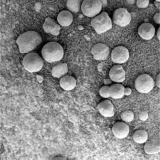
Martian spherules (also known as hematite spherules, blueberries, & Martian blueberries) are small spherules (roughly spherical pebbles) that are rich in an iron oxide (grey hematite, α-Fe2O3) and are found at Meridiani Planum (a large plain on Mars) in exceedingly large numbers.

<span class="mw-page-title-main">Scientific information from the Mars Exploration Rover mission</span>

NASA's 2003 Mars Exploration Rover Mission has amassed an enormous amount of scientific information related to the Martian geology and atmosphere, as well as providing some astronomical observations from Mars. This article covers information gathered by the Opportunity rover during the initial phase of its mission. Information on science gathered by Spirit can be found mostly in the Spirit rover article.

<span class="mw-page-title-main">Geology of Mars</span> Scientific study of the surface, crust, and interior of the planet Mars

The geology of Mars is the scientific study of the surface, crust, and interior of the planet Mars. It emphasizes the composition, structure, history, and physical processes that shape the planet. It is analogous to the field of terrestrial geology. In planetary science, the term geology is used in its broadest sense to mean the study of the solid parts of planets and moons. The term incorporates aspects of geophysics, geochemistry, mineralogy, geodesy, and cartography. A neologism, areology, from the Greek word Arēs (Mars), sometimes appears as a synonym for Mars's geology in the popular media and works of science fiction. The term areology is also used by the Areological Society.

<span class="mw-page-title-main">Medusae Fossae Formation</span> Large geological unit of uncertain origin on Mars

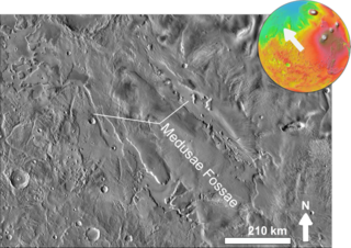
The Medusae Fossae Formation is a large geological formation of probable volcanic origin on the planet Mars. It is named for the Medusa of Greek mythology. "Fossae" is Latin for "trenches". The formation is a collection of soft, easily eroded deposits that extends discontinuously for more than 5,000 km along the equator of Mars. Its roughly-shaped regions extend from just south of Olympus Mons to Apollinaris Patera, with a smaller additional region closer to Gale Crater.

<span class="mw-page-title-main">Arabia quadrangle</span> Map of Mars

The Arabia quadrangle is one of a series of 30 quadrangle maps of Mars used by the United States Geological Survey (USGS) Astrogeology Research Program. The Arabia quadrangle is also referred to as MC-12.

<span class="mw-page-title-main">Oxia Palus quadrangle</span> Map of Mars

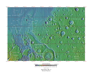
The Oxia Palus quadrangle is one of a series of 30 quadrangle maps of Mars used by the United States Geological Survey (USGS) Astrogeology Research Program. The Oxia Palus quadrangle is also referred to as MC-11.

<span class="mw-page-title-main">Aeolis quadrangle</span> One of a series of 30 quadrangle maps of Mars

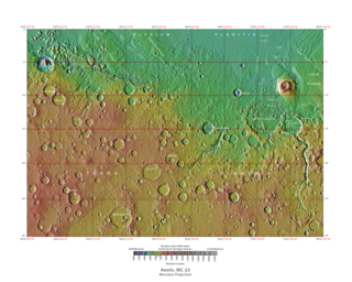
The Aeolis quadrangle is one of a series of 30 quadrangle maps of Mars used by the United States Geological Survey (USGS) Astrogeology Research Program. The Aeolis quadrangle is also referred to as MC-23 . The Aeolis quadrangle covers 180° to 225° W and 0° to 30° south on Mars, and contains parts of the regions Elysium Planitia and Terra Cimmeria. A small part of the Medusae Fossae Formation lies in this quadrangle.

<span class="mw-page-title-main">Coprates quadrangle</span> Map of Mars

The Coprates quadrangle is one of a series of 30 quadrangle maps of Mars used by the United States Geological Survey (USGS) Astrogeology Research Program. The Coprates quadrangle is also referred to as MC-18. The Coprates quadrangle contains parts of many of the old classical regions of Mars: Sinai Planum, Solis Planum, Thaumasia Planum, Lunae Planum, Noachis Terra, and Xanthe Terra.

<span class="mw-page-title-main">Margaritifer Sinus quadrangle</span> One of a series of 30 quadrangle maps of Mars

The Margaritifer Sinus quadrangle is one of a series of 30 quadrangle maps of Mars used by the United States Geological Survey (USGS) Astrogeology Research Program. The Margaritifer Sinus quadrangle is also referred to as MC-19. The Margaritifer Sinus quadrangle covers the area from 0° to 45° west longitude and 0° to 30° south latitude on Mars. Margaritifer Sinus quadrangle contains Margaritifer Terra and parts of Xanthe Terra, Noachis Terra, Arabia Terra, and Meridiani Planum.

<span class="mw-page-title-main">Water on Mars</span> Study of past and present water on Mars

Almost all water on Mars today exists as ice, though it also exists in small quantities as vapor in the atmosphere. What was thought to be low-volume liquid brines in shallow Martian soil, also called recurrent slope lineae, may be grains of flowing sand and dust slipping downhill to make dark streaks. While most water ice is buried, it is exposed at the surface across several locations on Mars. In the mid-latitudes, it is exposed by impact craters, steep scarps and gullies. Additionally, water ice is also visible at the surface at the north polar ice cap. Abundant water ice is also present beneath the permanent carbon dioxide ice cap at the Martian south pole. More than 5 million km3 of ice have been detected at or near the surface of Mars, enough to cover the whole planet to a depth of 35 meters (115 ft). Even more ice might be locked away in the deep subsurface. Some liquid water may occur transiently on the Martian surface today, but limited to traces of dissolved moisture from the atmosphere and thin films, which are challenging environments for known life. No evidence of present-day liquid water has been discovered on the planet's surface because under typical Martian conditions, warming water ice on the Martian surface would sublime at rates of up to 4 meters per year. Before about 3.8 billion years ago, Mars may have had a denser atmosphere and higher surface temperatures, potentially allowing greater amounts of liquid water on the surface, possibly including a large ocean that may have covered one-third of the planet. Water has also apparently flowed across the surface for short periods at various intervals more recently in Mars' history. Aeolis Palus in Gale Crater, explored by the Curiosity rover, is the geological remains of an ancient freshwater lake that could have been a hospitable environment for microbial life. The present-day inventory of water on Mars can be estimated from spacecraft images, remote sensing techniques, and surface investigations from landers and rovers. Geologic evidence of past water includes enormous outflow channels carved by floods, ancient river valley networks, deltas, and lakebeds; and the detection of rocks and minerals on the surface that could only have formed in liquid water. Numerous geomorphic features suggest the presence of ground ice (permafrost) and the movement of ice in glaciers, both in the recent past and present. Gullies and slope lineae along cliffs and crater walls suggest that flowing water continues to shape the surface of Mars, although to a far lesser degree than in the ancient past.

<span class="mw-page-title-main">Columbus (crater)</span> Crater on Mars

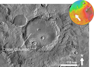
Columbus is a crater in the Terra Sirenum of Mars. It is 119 km in diameter and was named after Christopher Columbus, Italian explorer (1451–1506). The discovery of sulfates and clay minerals in sediments within Columbus crater are strong evidence that a lake once existed in the crater. Research with an orbiting near-infrared spectrometer, which reveals the types of minerals present based on the wavelengths of light they absorb, found evidence of layers of both clay and sulfates in Columbus crater. This is exactly what would appear if a large lake had slowly evaporated. Moreover, because some layers contained gypsum, a sulfate which forms in relatively fresh water, life could have formed in the crater.

<span class="mw-page-title-main">Henry (Martian crater)</span> Martian crater

Henry is a large crater in the Arabia quadrangle of Mars. It is 171 kilometres (106 mi) in diameter and was named after the brothers Paul Henry and Prosper Henry, both of whom were French telescope makers and astronomers.

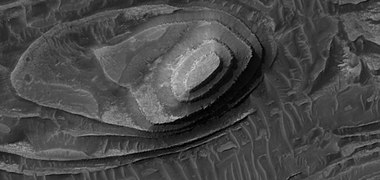
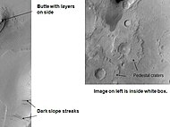
In planetary geology, a pedestal crater is a crater with its ejecta sitting above the surrounding terrain and thereby forming a raised platform. They form when an impact crater ejects material which forms an erosion-resistant layer, thus causing the immediate area to erode more slowly than the rest of the region. Some pedestals have been accurately measured to be hundreds of meters above the surrounding area. This means that hundreds of meters of material were eroded away. The result is that both the crater and its ejecta blanket stand above the surroundings. Pedestal craters were first observed during the Mariner missions.

Bouguer Crater is an impact crater in the Sinus Sabaeus quadrangle of Mars, located at 18.7° S and 332.8° W It is 107 km in diameter and was named after Pierre Bouguer, French physicist-hydrographer (1698–1758).

To date, interplanetary spacecraft have provided abundant evidence of water on Mars, dating back to the Mariner 9 mission, which arrived at Mars in 1971. This article provides a mission by mission breakdown of the discoveries they have made. For a more comprehensive description of evidence for water on Mars today, and the history of water on that planet, see Water on Mars.

<span class="mw-page-title-main">Evidence of water on Mars found by Mars Reconnaissance Orbiter</span>

The Mars Reconnaissance Orbiter's HiRISE instrument has taken many images that strongly suggest that Mars has had a rich history of water-related processes. Many features of Mars appear to be created by large amounts of water. That Mars once possessed large amounts of water was confirmed by isotope studies in a study published in March 2015, by a team of scientists showing that the ice caps were highly enriched with deuterium, heavy hydrogen, by seven times as much as the Earth. This means that Mars has lost a volume of water 6.5 times what is stored in today's polar caps. The water for a time would have formed an ocean in the low-lying Mare Boreum. The amount of water could have covered the planet about 140 meters, but was probably in an ocean that in places would be almost 1 mile deep.

<span class="mw-page-title-main">Composition of Mars</span> Branch of the geology of Mars

The composition of Mars covers the branch of the geology of Mars that describes the make-up of the planet Mars.

<span class="mw-page-title-main">Lakes on Mars</span> Overview of the presence of lakes on Mars

In summer 1965, the first close-up images from Mars showed a cratered desert with no signs of water. However, over the decades, as more parts of the planet were imaged with better cameras on more sophisticated satellites, Mars showed evidence of past river valleys, lakes and present ice in glaciers and in the ground. It was discovered that the climate of Mars displays huge changes over geologic time because its axis is not stabilized by a large moon, as Earth's is. Also, some researchers maintain that surface liquid water could have existed for periods of time due to geothermal effects, chemical composition or asteroid impacts. This article describes some of the places that could have held large lakes.

<span class="mw-page-title-main">Equatorial layered deposits</span> Surface geological deposits on Mars

Equatorial layered deposits (ELD’s) have been called interior layered deposits (ILDs) in Valles Marineris. They are often found with the most abundant outcrops of hydrated sulfates on Mars, and thus are likely to preserve a record of liquid water in Martian history since hydrated sulfates are formed in the presence of water. Layering is visible on meter scale, and when the deposits are partly eroded, intricate patterns become visible. The layers in the mound in Gale Crater have been extensively studied from orbit by instruments on the Mars Reconnaissance Orbiter. The Curiosity Rover landed in the crater, and it has brought some ground truth to the observations from satellites. Many of the layers in ELD’s such as in Gale Crater are composed of fine-grained, easily erodible material as are many other layered deposits. On the basis of albedo, erosion patterns, physical characteristics, and composition, researchers have classified different groups of layers in Gale Crater that seem to be similar to layers in other (ELD’s). The groups include: a small yardang unit, a coarse yardang unit, and a terraced unit. Generally, equatorial layered deposits are found ~ ±30° of the equator. Equatorial Layered Deposits appear in various geological settings such as cratered terrains, chaotic terrains, the Valles Marineris chasmata, and large impact craters.

References

  1. Grotzinger, J.P.; Arvidson, R.E.; Bell, III; Calvin, W.; Clark, B.C.; Fike, D.A.; Golombek, M.; Greeley, R.; Haldemann, A.; Herkenhoff, K.E.; Jolliff, B.L.; Knoll, A.H.; Malin, M.; McLennan, S.M.; Parker, T.; Soderblom, L.; Sohl-Dickstein, J.N.; Squyres, S.W.; Tosca, N.J.; Watters, W.A. (2005). "Stratigraphy and sedimentology of a dry to wet eolian depositional system, Burns formation, Meridiani Planum, Mars". Earth and Planetary Science Letters. 240 (1): 11–72. Bibcode:2005E&PSL.240...11G. doi:10.1016/j.epsl.2005.09.039.
  2. Carr, Michael H. (1995). "The Martian drainage system and the origin of valley networks and fretted channels". Journal of Geophysical Research. 100 (E4): 7479–7507. Bibcode:1995JGR...100.7479C. doi:10.1029/95JE00260.
  3. Carr, Michael H.; Chuang, Frank C. (1997). "Martian drainage densities". Journal of Geophysical Research. 102 (E4): 9145–9152. Bibcode:1997JGR...102.9145C. doi:10.1029/97JE00113.
  4. Baker, V. R. (1982), The Channels of Mars, 198 pp., Univ. of Tex. Press, Austin.
  5. Barnhart, Charles J.; Howard, Alan D.; Moore, Jeffrey M. (2009). "Long-term precipitation and late-stage valley network formation: Landform simulations of Parana Basin, Mars". Journal of Geophysical Research. 114 (E1): E01003. Bibcode:2009JGRE..114.1003B. doi: 10.1029/2008JE003122 .
  6. Howard, Alan D.; Moore, Jeffrey M.; Irwin, Rossman P. (2005). "An intense terminal epoch of widespread fluvial activity on early Mars: 1. Valley network incision and associated deposits". Journal of Geophysical Research. 110 (E12): E12S14. Bibcode:2005JGRE..11012S14H. doi: 10.1029/2005JE002459 .
  7. Stepinski, T. F.; Stepinski, A. P. (2005). "Morphology of drainage basins as an indicator of climate on early Mars". Journal of Geophysical Research. 110 (E12): E12S12. Bibcode:2005JGRE..11012S12S. doi: 10.1029/2005JE002448 .
  8. 1 2 Andrews, Robin George (20 September 2019). "Mysterious magnetic pulses discovered on Mars - The nighttime events are among initial results from the InSight lander, which also found hints that the red planet may host a global reservoir of liquid water deep below the surface". National Geographic Society . Archived from the original on 20 September 2019. Retrieved 20 September 2019.
  9. 1 2 Andrews-Hanna, Jeffrey C.; Phillips, Roger J.; Zuber, Maria T. (2007). "Meridiani Planum and the global hydrology of Mars". Nature. 446 (7132): 163–6. Bibcode:2007Natur.446..163A. doi:10.1038/nature05594. PMID   17344848. S2CID   4428510.
  10. Salese, Francesco; Pondrelli, Monica; Neeseman, Alicia; Schmidt, Gene; Ori, Gian Gabriele (2019). "Geological Evidence of Planet-Wide Groundwater System on Mars". Journal of Geophysical Research: Planets. 124 (2): 374–395. Bibcode:2019JGRE..124..374S. doi:10.1029/2018JE005802. PMC   6472477 . PMID   31007995.
  11. Burns, Roger G (1993). "Rates and mechanisms of chemical weathering of ferromagnesian silicate minerals on Mars". Geochimica et Cosmochimica Acta. 57 (19): 4555–4574. Bibcode:1993GeCoA..57.4555B. doi:10.1016/0016-7037(93)90182-V.
  12. Burns, Roger G.; Fisher, Duncan S. (1993). "Rates of Oxidative Weathering on the Surface of Mars". Journal of Geophysical Research. 98 (E2): 3365–3372. Bibcode:1993JGR....98.3365B. doi:10.1029/92JE02055.
  13. Hurowitz, J. A.; Fischer, W. W.; Tosca, N. J.; Milliken, R. E. (2010). "Origin of acidic surface waters and the evolution of atmospheric chemistry on early Mars" (PDF). Nat. Geosci. 3 (5): 323–326. Bibcode:2010NatGe...3..323H. doi:10.1038/ngeo831.
  14. Andrews-Hanna, Jeffrey C.; Lewis, Kevin W. (2011). "Early Mars hydrology: 2. Hydrological evolution in the Noachian and Hesperian epochs". Journal of Geophysical Research. 116 (E2): E02007. Bibcode:2011JGRE..116.2007A. doi: 10.1029/2010JE003709 . S2CID   17293290.
  15. Andrews-Hanna, J., K. Lewis. 2011. Early Mars hydrology:2. Hydrological evolution in the Noachian and Hesperian epochs. JOURNAL OF GEOPHYSICAL RESEARCH, VOL. 116, E02007, doi : 10.1029/2010JE003709.
  16. Schwenzer, S. P., et al. 2016. Fluids during diagenesis and sulfate vein formation in sediments at Gale Crater, Mars, Meteorit. Planet. Sci., 51(11), 2175–2202, doi : 10.1111/maps.12668.
  17. L'Haridon, J., N. Mangold, W. Rapin, O. Forni, P.-Y. Meslin, E. Dehouck, M. Nachon, L. Le Deit, O. Gasnault, S. Maurice, R. Wiens. 2017. Identification and implications of iron detection within calcium sulfate mineralized veins by ChemCam at Gale crater, Mars, paper presented at 48th Lunar and Planetary Science Conference, The Woodlands, Tex., Abstract 1328.
  18. Lanza, N. L., et al. 2016. Oxidation of manganese in an ancient aquifer, Kimberley formation, Gale crater, Geophys. Res. Lett., 43, 7398–7407, doi : 10.1002/2016GL069109.
  19. Frydenvang, J., et al. 2017. Diagenetic silica enrichment and late-stage groundwater activity in Gale crater, Mars, Gale, Mars, Geophys. Res. Lett., 44, 4716–4724, doi : 10.1002/2017GL073323.
  20. Yen, A. S., et al. 2017. Multiple stages of aqueous alteration along fractures in mudstone and sandstone strata in Gale Crater, Mars, Earth Planet. Sci. Lett., 471, 186–198, doi : 10.1016/j.epsl.2017.04.033.
  21. Nachon, M., et al. 2014. Calcium sulfate veins characterized by ChemCam/Curiosity at Gale crater, Mars, J. Geophys. Res. Planets, 119, 1991–2016, doi : 10.1002/2013JE004588
  22. Edgett, Kenneth S. (2005). "The sedimentary rocks of Sinus Meridiani: Five key observations from data acquired by the Mars Global Surveyor and Mars Odyssey orbiters". The Mars Journal. 1: 5–58. Bibcode:2005IJMSE...1....5E. doi:10.1555/mars.2005.0002.
  23. Malin, M. P.; Edgett, K. S. (2000). "Ancient sedimentary rocks of early Mars". Science. 290 (5498): 1927–1937. Bibcode:2000Sci...290.1927M. doi:10.1126/science.290.5498.1927. PMID   11110654.
  24. Fassett, Caleb I.; Head, James W. (2007). "Layered mantling deposits in northeast Arabia Terra, Mars: Noachian-Hesperian sedimentation, erosion, and terrain inversion". Journal of Geophysical Research. 112 (E8): E08002. Bibcode:2007JGRE..112.8002F. doi: 10.1029/2006JE002875 .
  25. Fergason, R. L.; Christensen, P. R. (2008). "Formation and erosion of layered materials: Geologic and dust cycle history of eastern Arabia Terra, Mars". Journal of Geophysical Research. 113 (E12): 12001. Bibcode:2008JGRE..11312001F. doi: 10.1029/2007JE002973 .
  26. Lewis, K. W.; Aharonson, O.; Grotzinger, J. P.; Kirk, R. L.; McEwen, A. S.; Suer, T.-A. (2008). "Quasi-Periodic Bedding in the Sedimentary Rock Record of Mars" (PDF). Science. 322 (5907): 1532–5. Bibcode:2008Sci...322.1532L. doi:10.1126/science.1161870. PMID   19056983. S2CID   2163048.
  27. Lewis, K. W., O. Aharonson, J. P. Grotzinger, A. S. McEwen, and R. L. Kirk (2010), Global significance of cyclic sedimentary deposits on Mars, Lunar Planet. Sci., XLI, Abstract 2648.
  28. Habermehl, M. A. (1980). "The Great Artesian Basin, Australia". J. Austr. Geol. Geophys. 5: 9–38.
  29. 1 2 ESA Staff (28 February 2019). "First Evidence of "Planet-Wide Groundwater System" on Mars Found". European Space Agency . Retrieved 28 February 2019.
  30. 1 2 Houser, Kristin (28 February 2019). "First Evidence of "Planet-Wide Groundwater System" on Mars Found". Futurism.com. Retrieved 28 February 2019.
  31. Morgan, A.M.; Howard, A.D.; Hobley, D.E.J.; Moore, J.M.; Dietrich, W.E.; Williams, R.M.E.; Burr, D.M.; Grant, J.A.; Wilson, S.A.; Matsubara, Y. (2014). "Sedimentology and climatic environment of alluvial fans in the martian Saheki crater and a comparison with terrestrial fans in the Atacama Desert". Icarus. 229: 131–156. Bibcode:2014Icar..229..131M. doi:10.1016/j.icarus.2013.11.007.
  32. Andrews-Hanna, Jeffrey C.; Zuber, Maria T.; Arvidson, Raymond E.; Wiseman, Sandra M. (2010). "Early Mars hydrology: Meridiani playa deposits and the sedimentary record of Arabia Terra". Journal of Geophysical Research. 115 (E6): E06002. Bibcode:2010JGRE..115.6002A. doi:10.1029/2009JE003485. hdl: 1721.1/74246 .
  33. Arvidson, R. E.; Poulet, F.; Morris, R. V.; Bibring, J.-P.; Bell, J. F.; Squyres, S. W.; Christensen, P. R.; Bellucci, G.; Gondet, B.; Ehlmann, B. L.; Farrand, W. H.; Fergason, R. L.; Golombek, M.; Griffes, J. L.; Grotzinger, J.; Guinness, E. A.; Herkenhoff, K. E.; Johnson, J. R.; Klingelhöfer, G.; Langevin, Y.; Ming, D.; Seelos, K.; Sullivan, R. J.; Ward, J. G.; Wiseman, S. M.; Wolff, M. (2006). "Nature and origin of the hematite-bearing plains of Terra Meridiani based on analyses of orbital and Mars Exploration rover data sets" (PDF). Journal of Geophysical Research. 111 (E12): n/a. Bibcode:2006JGRE..11112S08A. doi: 10.1029/2006JE002728 .
  34. Baker, V. R. (1982), The Channels of Mars, 198 pp., Univ. of Tex. Press
  35. "Opportunity Rover Finds Strong Evidence Meridiani Planum Was Wet" . Retrieved 8 July 2006.
  36. Grotzinger, J.P.; Arvidson, R.E.; Bell, J.F.; Calvin, W.; Clark, B.C.; Fike, D.A.; Golombek, M.; Greeley, R.; Haldemann, A.; Herkenhoff, K.E.; Jolliff, B.L.; Knoll, A.H.; Malin, M.; McLennan, S.M.; Parker, T.; Soderblom, L.; Sohl-Dickstein, J.N.; Squyres, S.W.; Tosca, N.J.; Watters, W.A. (2005). "Stratigraphy and sedimentology of a dry to wet eolian depositional system, Burns formation, Meridiani Planum, Mars". Earth and Planetary Science Letters. 240 (1): 11–72. Bibcode:2005E&PSL.240...11G. doi:10.1016/j.epsl.2005.09.039.
  37. McLennan, S.M.; Bell, J.F.; Calvin, W.M.; Christensen, P.R.; Clark, B.C.; De Souza, P.A.; Farmer, J.; Farrand, W.H.; Fike, D.A.; Gellert, R.; Ghosh, A.; Glotch, T.D.; Grotzinger, J.P.; Hahn, B.; Herkenhoff, K.E.; Hurowitz, J.A.; Johnson, J.R.; Johnson, S.S.; Jolliff, B.; Klingelhöfer, G.; Knoll, A.H.; Learner, Z.; Malin, M.C.; McSween, H.Y.; Pocock, J.; Ruff, S.W.; Soderblom, L.A.; Squyres, S.W.; Tosca, N.J.; et al. (2005). "Provenance and diagenesis of the evaporite-bearing Burns formation, Meridiani Planum, Mars". Earth and Planetary Science Letters. 240 (1): 95–121. Bibcode:2005E&PSL.240...95M. doi:10.1016/j.epsl.2005.09.041.
  38. Squyres, Steven W.; Knoll, Andrew H. (2005). "Sedimentary rocks at Meridiani Planum: Origin, diagenesis, and implications for life on Mars". Earth and Planetary Science Letters. 240 (1): 1–10. Bibcode:2005E&PSL.240....1S. doi:10.1016/j.epsl.2005.09.038.
  39. Karsenti, E.; Vernos, I. (October 2001). "The mitotic spindle: a self-made machine". Science. 294 (5542): 543–7. Bibcode:2001Sci...294..543K. doi:10.1126/science.1063488. PMID   11641489. S2CID   32846903.
  40. M. Wiseman, J. C. Andrews-Hanna, R. E. Arvidson, J. F. Mustard, K. J. Zabrusky DISTRIBUTION OF HYDRATED SULFATES ACROSS ARABIA TERRA USING CRISM DATA: IMPLICATIONS FOR MARTIAN HYDROLOGY. 42nd Lunar and Planetary Science Conference (2011) 2133.pdf
  41. Murchie, Scott; Roach, Leah; Seelos, Frank; Milliken, Ralph; Mustard, John; Arvidson, Raymond; Wiseman, Sandra; Lichtenberg, Kimberly; Andrews-Hanna, Jeffrey; Bishop, Janice; Bibring, Jean-Pierre; Parente, Mario; Morris, Richard (2009). "Evidence for the origin of layered deposits in Candor Chasma, Mars, from mineral composition and hydrologic modeling". Journal of Geophysical Research. 114 (E12): E00D05. Bibcode:2009JGRE..114.0D05M. doi: 10.1029/2009JE003343 .
  42. Gendrin, A.; Mangold, N; Bibring, JP; Langevin, Y; Gondet, B; Poulet, F; Bonello, G; Quantin, C; et al. (2005). "Sulfates in Martian Layered Terrains: The OMEGA/Mars Express View". Science. 307 (5715): 1587–91. Bibcode:2005Sci...307.1587G. doi: 10.1126/science.1109087 . PMID   15718429. S2CID   35093405.
  43. Roach, Leah H.; Mustard, John F.; Swayze, Gregg; Milliken, Ralph E.; Bishop, Janice L.; Murchie, Scott L.; Lichtenberg, Kim (2010). "Hydrated mineral stratigraphy of Ius Chasma, Valles Marineris". Icarus. 206 (1): 253–268. Bibcode:2010Icar..206..253R. doi:10.1016/j.icarus.2009.09.003.
  44. 1 2 3 Salese, Francesco; Pondrelli, Monica; Neeseman, Alicia; Schmidt, Gene; Ori, Gian Gabriele (2019). "Geological Evidence of Planet-Wide Groundwater System on Mars". Journal of Geophysical Research: Planets. 124 (2): 374–395. Bibcode:2019JGRE..124..374S. doi:10.1029/2018JE005802. PMC   6472477 . PMID   31007995.
  45. David, Leonard (19 February 2019). "Mars: Planet-Wide Groundwater System – New Geological Evidence". Leonard David's Inside Outer Space. Retrieved 7 October 2023.
  46. "First Evidence of a Planet-wide Groundwater System on Mars - Astrobiology". 28 February 2019.