Classical albedo features on Mars

Last updated
Marssep5.jpg
True color
Marsrglobe2004.gif
Enhanced
Mars, as seen through a small telescope in 2003, showing the patterns of brightness and color known as albedo features.

The classical albedo features of Mars are the light and dark features that can be seen on the planet Mars through an Earth-based telescope. Before the age of space probes, several astronomers created maps of Mars on which they gave names to the features they could see. The most popular system of nomenclature was devised by Giovanni Schiaparelli, who used names from classical antiquity. Today, the improved understanding of Mars enabled by space probes has rendered many of the classical names obsolete for the purposes of cartography; however, some of the old names are still used to describe geographical features on the planet.

Contents

History

Observing albedo features

Richard A. Proctor's map of Mars, which named albedo features after astronomers. North is at the bottom, as seen through an inverting telescope. Proctor Mars Map.jpg
Richard A. Proctor's map of Mars, which named albedo features after astronomers. North is at the bottom, as seen through an inverting telescope.

Early telescopic astronomers, observing Mars from a great distance through primitive instruments (though they were advanced for their day), were limited to studying albedo contrasts on the surface of the planet. These lighter and darker patches rarely correspond to topographic features and in many cases obscure them. The origins of the albedo contrasts were a mystery. The lighter patches at the poles were correctly believed to be a frozen substance, either water or carbon dioxide, but the nature of the dark patches seen against the general reddish tint of Mars was uncertain for centuries. When Giovanni Schiaparelli began observing Mars in 1877, he believed that the darker features were seas, lakes, and swamps and named them accordingly in Latin (mare, lacus, palus etc.). Within a few decades, however, most astronomers came to agree that Mars lacks large bodies of surface water. The dark features were then thought by some to be indications of Martian vegetation, since they changed shape and intensity over the course of the Martian year. They are now known to be areas where the wind has swept away the paler dust, exposing a darker surface, often basaltic rock; so their borders change in response to windstorms on the Martian surface that move the dust around, widening or narrowing the features.

The dust-storms themselves also appear as light patches, can cover vast areas and sometimes last for many weeks; when Mariner 9 arrived in Martian orbit in November 1971 the entire planet was covered by a single enormous dust-storm, with only the peaks of the four or five highest mountains showing above it. This variability may explain many of the differences between telescopic observations over the years.

Early non-classical names

The first map of Martian albedo features was published in 1840 by Johann Heinrich Mädler and Wilhelm Beer, but they simply labelled the features a, b, c ... without giving them names. Over the next two decades the most prominent features picked up various informal names (such as the Hourglass Sea for our Syrtis Major Planum) but there was no overall system.

Nathaniel Green's 1877 Mars map, which used many of Proctor's names. North is at the bottom. Nathaniel Green Mars map -556069113.jpg
Nathaniel Green's 1877 Mars map, which used many of Proctor's names. North is at the bottom.

The first astronomer to name Martian albedo features systematically was Richard A. Proctor, who in 1867 created a map (based in part on the observations of William Rutter Dawes) in which several features were given the names of astronomers who had been involved in mapping Mars. In some cases, the same names were used for multiple features. Proctor's names remained in use for several decades, notably in several early maps drawn by Camille Flammarion in 1876 and Nathaniel Green in 1877.

Schiaparelli's classical names

Early Schiaparelli map, from an 1888 encyclopedia. Karte Mars Schiaparelli MKL1888.png
Early Schiaparelli map, from an 1888 encyclopedia.

However, within a few decades Proctor's names were superseded by a new scheme devised by Giovanni Schiaparelli, whose observations differed from Proctor's, and who used this difference to justify drawing up an entirely new system of nomenclature. Schiaparelli was an expert on ancient astronomy and geography, and used Latin names, drawn from the myths, history and geography of classical antiquity; dark features were named after ancient seas and rivers, light areas after islands and legendary lands.

Early map by Flammarion and Antoniadi. North is at the bottom. Martian Channels by Flamarion&Antoniadi.jpg
Early map by Flammarion and Antoniadi. North is at the bottom.

When E. M. Antoniadi took over as the leading telescopic observer of Mars in the early 20th century, he followed Schiaparelli's names rather than Proctor's, and the Proctorian names quickly became obsolete. In his encyclopedic work La Planète Mars (1930) Antoniadi used all Schiaparelli's names and added more of his own from the same classical sources. However, there was still no 'official' system of names for Martian features.

In 1958, the International Astronomical Union set up an ad hoc committee under Audouin Dollfus, which settled on a list of 128 officially recognised albedo features. Of these, 105 came from Schiaparelli, 2 from Flammarion, 2 from Percival Lowell, and 16 from Antoniadi, with an additional 3 from the committee itself. This involved a considerable amount of pruning; Antoniadi's La Planète Mars had mentioned 558 named features. [1] [2] [3]

The pictures returned by interplanetary spacecraft, notably the observations made from Martian orbit by Mariner 9 over the course of 1972, have revolutionized the scientific understanding of Mars, and some of the classical albedo features have become obsolete as they do not correspond clearly with the detailed images provided by the spacecraft. However, many of the names used for topographic features on Mars are still based on the classical nomenclature for the feature's location; for instance, the albedo feature 'Ascraeus Lacus' provides the basis of the name of the volcano Ascraeus Mons in roughly the same position.

In addition, since most Earth-based amateur telescopes are not powerful enough to resolve the topographic surface features of Mars, amateur astronomers still use many of the old feature-names to orient themselves and record their observations.

Mars Geolocalisation.jpg
Mars albedo features after the 1958 official list of names, but before the 1972 observations of Mariner 9. Mars albedo features NASA 1970.JPG
Mars albedo features after the 1958 official list of names, but before the 1972 observations of Mariner 9.

Common feature names

Classical albedo features on Mars, whose names date back to Schiaparelli (1888 map above) share some boundaries with more recent satellite observations. Schiaparelli versus Mars.jpg
Classical albedo features on Mars, whose names date back to Schiaparelli (1888 map above) share some boundaries with more recent satellite observations.

Several Latin words involved here are common nouns. These are generally, but not always, second in the name, but are usually ignored in alphabetizing below:

List of albedo features

Not listed here are the "canals" also observed and named by Schiaparelli, for which see the article Martian canals.

Note that the pronunciation refers to English pronunciation, not Latin or Italian.

A

Name Pronunciation MeaningModern name(s)
Abalos /ˈæbəlɒs/ A no-longer existent island in the North Sea, east of Heligoland Abalos Colles, Abalos Mensa, Abalos Scopuli, Abalos Undae
Achæorum Portus /ˌækˈɔːrəmˈpɔːrtəs/ "Harbor of the Achaeans"Obsolete
Acherusia Palus /ˌækɪˈrʒiəˈpləs/ "Marsh of Acherusia", named after the legendary swamps in Greek mythologyObsolete
Achillis Pons /əˈkɪlɪsˈpɒnz/ "Bridge of Achilles"Obsolete
Mare Acidalium /ˈmɛərˌæsɪˈdliəm/ "Sea of Acidalia", named for the fountain Acidalia where the Graces bathed Acidalia Colles, Acidalia Mensa, Acidalia Planitia
Æolis /ˈəlɪs/ a modification of Aeolia, the name of the floating western island of Aiolos, the ruler of the winds Aeolis Mensae, Aeolis Planum
Aëria /ˈɪəriə/ From a poetic name for Egypt Aeria, IAU recognized albedo feature
Ætheria /ɪˈθɪəriə/ – the land of the living, as referred to in Virgil's Aeneid Aetheria, IAU recognized albedo feature
Æthiopis /ɪˈθəpɪs/ Land of the Ethiopians Aethiopis, IAU recognized albedo feature
Aganippe Fons /ˌæɡəˈnɪpˈfɒnz/ "Aganippe's Fountain", legendary home of a Greek naiad Aganippe Fossa
Alcyonia /ˌælsiˈniə/ Land of kingfishers.Obsolete
Amazonis /əˈmæzənɪs/ "Land of the Amazon", legendary warrior women Amazonis Mensa, Amazonis Planitia, Amazonis Sulci
Amenthes /əˈmɛnθz/ Alternate name for Duat, the Egyptian land of the dead Amenthes Cavi, Amenthes Fossae, Amenthes Planum, Amenthes Rupes
Ammonium /əˈmniəm/ Ancient name for the Siwa Oasis Obsolete
Mare Amphitrites /ˈmɛərˌæmfɪˈtrtz/ "Sea of Amphitrite", a Greek sea-goddess Amphitrites Patera
Lucus Angitiæ /ˈljkəsænˈɪʃɪ/ "Grove of Angitia", named after the snake goddessObsolete
Depressiones Aoniæ /dɪˌprɛʃiˈnzˈnɪ/ "Lowlands of the Muses", who came from Helicon in Aonia [ citation needed ]Obsolete
Aonius Sinus /ˈniəsˈsnəs/ "Bay of the Muses"[ citation needed ]Aonia Mons, Aonia Planum, Aonia Terra, Aonia Tholus
Aponi Fons /ˈæpənˈfɒnz/ Roman name for the Bagni d'Abano, warm-water baths near Padua Obsolete
Aquæ Apollinares /ˈkwəˌpɒlɪˈnɛərz/ "Apollo's Waters"; Roman name for the Bagni di Stigliano baths in Canale Monterano, Tuscany [ citation needed ]Obsolete
Aquæ Calidæ /ˈkwˈkælɪd/ "Hot spring"Obsolete
Aquarii Depressio /əˈkwɛəridɪˈprɛʃi/ "Lowland of Aquarius"Obsolete
Arabia /əˈrbiə/ Arabian peninsula Arabia Terra
Arachoti Fons /ˌærəˈktˈfɒnz/ "Fountain of Arachotus", a river in Afghanistan [ citation needed ]Obsolete
Aram /ˈɛərəm/ Aram, Biblical land of the Aramaeans Aram Chaos
Arcadia /ɑːrˈkdiə/ From Arcadia, a region of the central Peloponnesus Arcadia Chaos, Arcadia Dorsa, Arcadia Planitia
Arduenna /ˌɑːrdjuˈɛnə/ Latin names for the Ardennes forestsObsolete
Arethusa Fons /ˌærɪˈθjzəˈfɒnz/ "Arethusa's Fountain", after the Greek nymphObsolete
Argyre I /ˈɑːrərˈprmə/ One of a pair of legendary islands, Chryse and Argyre, located in the Indian Ocean and said to be made of gold and silver Argyre Cavi, Argyre Planitia, Argyre Rupes, Argyre quadrangle
Argyre II /ˈɑːrərsɪˈkʌndə/ "Second Silver Land" (see above)Obsolete
Argyroporos /ˌɑːrɪˈrɒpərɒs/ "Silver Strait"Obsolete
Ariadnes Depressio /ˌæriˈædnzdɪˈprɛʃi/ "Lowland of Ariadne", a Greek heroine Ariadnes Colles
Aromatum Promontorium /əˈrɒmətəmˌprɒmənˈtɔːriəm/ "Cape of Fragrant Spices"[ citation needed ] Aromatum Chaos
Arsia Silva /ˈɑːrʃiəˈsɪlvə/ Arsia Silva, forest northwest of Rome where the Tarquinii were defeated Arsia Chasmata, Arsia Mons, Arsia Sulci
Arsinoës Depressio /ɑːrˈsɪnzdɪˈprɛʃi/ Lowland of Arsinoë, the name of various Greek and Egyptian figures Arsinoes Chaos
Artynia Fons /ɑːrˈtɪniəfɒnz/ "Artynia's Fountain", referring to Lake Artynia in Asia Minor Artynia Catena
Aryn Promontorium /ˈɛərɪnˌprɒmənˈtɔːriəm/ "Cape of Aryn"Obsolete
Fastigium Aryn /fæsˈtɪiəmˈɛərɪn/ "Summit of Aryn"Obsolete
Ascræus Lacus /æˈskrəsˈlkəs/ "Ascraeus Lake", a poetic paraphrase of "heliconian" or "rural"[ citation needed ] Ascraeus Chasmata, Ascraeus Mons, Ascraeus Sulci
Astræ Lacus /ˈæstrˈlkəs/ "Lake of the Astra", Greek star-gods [ citation needed ]Obsolete
Atalantes Depressio /ætəˈlæntzdɪˈprɛʃi/ Lowland of Atalanta, Greek heroineObsolete
Nix Atlantica /ˈnɪksætˈlæntɪkə/ "Snows of Atlas",[ citation needed ] a Titan in Greek mythologyObsolete
Atlantidum Sinus /ætˈlæntɪdəmˈsnəs/ "Bay of the Atlantises" (just south of Atlantis I and II, see below)Obsolete
Atlantis I /ætˈlæntɪsˈprmə/ "First Atlantis", mythical drowned land Atlantis Chaos
Atlantis II /ætˈlæntɪssɪˈkʌndə/ "Second Atlantis" (see above) Atlantis Chaos
Augila /ˈɔːələ/ Awjila, a city in Cyrenaica Obsolete
Aurea Cherso /ˈɔːrəˈkɜːrs/ "Golden Peninsula", ancient name for the Malay Peninsula Obsolete
Aureum Cornu /ˈɔːrəmˈkɔːrnj/ "Golden Horn", inlet dividing Constantinople Aureum Chaos
Auroræ Sinus /ɔːˈrɔːrˈsnəs/ "Bay of the Dawn" Aurorae Planum, Aurorae Chaos
Ausonia /ɔːˈzniə/ From a poetic name for Italy Ausonia Cavus, Ausonia Mensa, Ausonia Montes
Mare Australe /ˈmɛərɒsˈtrl/ "Southern Sea" Chasma Australe, Australe Lingula, Australe Mensa, Australe Montes, Planum Australe, Australe Scopuli, Australe Sulci, Mare Australe quadrangle

B-E

Name Pronunciation MeaningModern name(s)
Baltia /ˈbælʃiə/ From a name for the regions near the Baltic Sea Baltia, IAU recognized albedo feature
Bandusiæ Fons /bænˈdjʒɪˈfɒnz/ "Fountain of Bandusia", title of a poem by Horace Obsolete
Bathys Portus /ˈbθɪsˈpɔːrtəs/ "Deep Harbor", the port of Aulis in Boeotia [ citation needed ]Bathys Planum, changed to Icaria Planum
Benacus Lacus /bɪˈnkəsˈlkəs/ "Lake Benacus" (Lago di Garda in northern Italy)Obsolete
Biblis Fons /ˈbɪblɪsˈfɒnz/ "Biblis Fountain", a Carian well near Miletus [ citation needed ] Biblis Patera, Biblis Tholus
Bosporium Promontorium /bɒsˈpɔːriəmˌprɒmənˈtɔːriəm/ "Cape of the Bosphorus"
Bosporus/Bosphorus Gemmatus /ˈbɒspərəs,ˈbɒsfərəsɪˈmtəs/ "Bejewelled Bosphorus" Bosporos Planum, Bosporus Regio, Bosporos Rupes
Brangæna /brænˈnə/ Obsolete
Capri"Isle of Capri" Capri Chasma, Capri Mensa
Casius Mt Casius in Egypt, famous in antiquity for the nearby coastal marshes in which whole armies were reputed to have drowned Casius quadrangle
Castalia Fons /kæsˈtliəfɒnz/ "Castalian Springs"
Cebrenia /sɪˈbrniə/ Land of Cebrenia near Troy Cebrenia quadrangle
Cecropia /sɪˈkrpiə/ "Land of Cecrops"
Ceraunius /sɪˈrɔːniəs/ Ceraunius Catena, Ceraunius Fossae
Chalce /ˈkæls/ Chalce Montes
Charitum Promontorium /ˈkærɪtəmˌprɒmənˈtɔːriəm/ "Cape of the Graces" Charitum Montes
Chironis Fretum /kˈrnɪsˈfrtəm/ "Strait of Chiron"
Mare Chronium /ˈmɛərˈkrniəm/ Planum Chronium, Chronius Mons
Chryse /ˈkrs/ One of a pair of legendary islands, Chryse and Argyre, located in the Indian Ocean and said to be made of gold and silverChryse Chaos, Chryse Colles, Chryse Planitia
Chrysokeras /krɪˈsɒkərəs/ The Golden Horn
Cimmeria Insula /sɪˈmɪəriəˈɪnsjʊlə/ "Cimmerian Island"Obsolete
Mare Cimmerium /ˈmɛərsɪˈmɪəriəm/ "Cimmerian Sea", named after an ancient Thracian seafaring people Terra Cimmeria
Circaeum Promontorium /sərˈsəmˌprɒmənˈtɔːriəm/ "Cape of Circe"
ClaritasLatin for "bright" Claritas Fossae, Claritas Rupes
Clepsydra Fons /klɛpˈsdrəˈfɒnz/ "Water-clock fountain", a well in the Athenian acropolis.
Coprates /ˈkɒprətz/ River Coprates, now called the Dez, in modern Iran Coprates Chasma
Coracis Portus /ˈkɒrəsɪsˈpɔːrtəs/ "Haven of Corax"
Cyane Fons /ˈsənˈfɒnz/ "Cyane fountain", a spring in Sicily from which the Cyane river sprang, named for a nymph.Cyane Catena, Cyane Fossae
Cydonia /sˈdniə/ poetic name for Crete Cydonia, Cydonia Mensae, Cydonia Labyrinthus, Cydonia Colles
Cynia Lacus
Danaïdum Depressio /dəˈnədəmdɪˈprɛʃi/ "Lowland of the daughters of Danaüs"
Daphne /ˈdæfn/ From Daphne ("bay laurel"), a nymph pursued by Apollo.
Deucalionis Regio /djˌkliˈnɪsˈri/ "Region of Deucalion"
Dia /ˈdə/ An island north of Crete
Diacria /dˈkriə/ Diacria highlands around Marathon Diacria quadrangle
Dioscuria /ˌdəsˈkjʊəriə/ "Land of the Dioscuri"
Eden /ˈdən/ From Eden, the biblical paradise Eden Patera
Edom /ˈdəm/ From Edom, an ancient kingdom in modern Jordan
Edom Promontorium /ˈdəmˌprɒmənˈtɔːriəm/ "Cape of Edom"
Electris /ɪˈlɛktrɪs/ The principal island of the "Electrides", islands said to produce amber.Electris Mons
Elysium /ɪˈlɪʒiəm/ From Elysium, the Greek land of dead heroes Elysium Planitia, Elysium Mons, Elysium Fossae, Elysium quadrangle
Eridania /ˌɛrɪˈdniə/ Land of the River Eridanus Eridania Mons, Eridania Planitia, Eridania quadrangle, Eridania Scopulus
Mare Erythræum /ˈmɛərˌɛrɪˈθrəm/ "Red Sea"Erythraea Fossae

F-L

Name Pronunciation MeaningModern name(s)
Famæ Depressio /ˈfmdɪˈprɛʃi/ "Lowland of Fame"
Ferentinæ Lucus /ˌfɛrɪnˈtnˈljkəs/ "Grove of Ferentina"
Lucus Feronia"Grove of Wild Beasts"
Flevo Lacus /ˈflvˈlkəs/
Gallinaria Silva /ˌɡælɪˈnɛəriəˈsɪlvə/
Mare Hadriaticum /ˈmɛərˌhdriˈætɪkəm/ "Adriatic Sea" Aka Hadriaticum Mare Hadriacus Mons, Hadriaca Patera
Hammonis Cornu /həˈmnɪsˈkɔːrnj/ "Horn of Ammon"
Hellas /ˈhɛləs/ "Greece" Hellas Planitia, Hellas Montes, Hellas quadrangle
Heræum Promontorium /hɪˈrəmˌprɒmənˈtɔːriəm/ "Cape of Hera"
Hercynia Silva /hɜːrˈsɪniəˈsɪlvə/ Hercynian Forest
Herculis Columnæ /ˈhɜːrkjʊlɪskɒˈlʌmn/ "Pillars of Hercules"
Herculis Pons /ˈhɜːrkjʊlɪsˈpɒnz/ "Bridge of Hercules"
Hesperia /hɛsˈpɪəriə/ "Land of the Setting Sun"Hesperia Dorsa, Hesperia Planum
Hesperidum Lacus /hɛsˈpɛrɪdəmˈlkəs/ "Lake of the Hesperides
Hibe /ˈhb/
Hippocrene Fons /ˌhɪpəˈkrnˈfɒnz/ "Fountain of Hippocrene", near Mount Helicon
Hipponitis Palus
Horarum Promontorium /hɒˈrɛərəmˌprɒmənˈtɔːriəm/ "Cape of the Hours"Horarum Mons
Hypelaus /ˌhɪpɪˈləs/ A fountain in Ephesus.
Hyperboreus LacusGreek/Latin: Far Northern Lake Hyperboreae Undae
Iapygia /ˌəˈpɪiə/ Salento in Italy, ancient home of the Iapyges Iapygia quadrangle
Icaria /ˈkɛəriə/ Icaria Fossae, Icaria Planum
Mare Icarium /ˈmɛərˈkɛəriəm/
Ierne /ˈɜːrn/ A name for Ireland
Isidis Regio /ˈɪsɪdɪsˈri/ "Region of Isis" Isidis Planitia
Ismenius Lacus /ɪzˈmniəsˈlkəs/ The Ismenian Spring near Thebes where Cadmus slew the guardian dragonIsmenia Patera, Ismeniae Fossae Ismenius Cavus, Ismenius Lacus quadrangle
Jani Fretum /ˈnˈfrtəm/ "Strait of Janus" Iani Chaos
Juventæ Fons /ˈvɛntˈfɒnz/ "Fountain of Youth" a.k.a. Fons Juventæ Juventae Chasma, Juventae Dorsa
Labeatis Lacus /læbˈtɪsˈlkəs/ Lake of the Labeates, a people of Illyria
Lausonius Lacus /lɔːˈsniəsˈlkəs/
Lemuria /lɪˈmjʊəriə/ From Lemuria, a fictional sunken land in the Pacific or Indian Ocean
Lerne /ˈlɜːrn/
Libya /ˈlɪbiə/ "Libya" Libya Montes
Lucrinus LacusThe Lucrine Lake in Roman Italy
Lunæ Lacus /ˈljnˈlkəs/ "Lake of the Moon" a.k.a. Lacus Lunæ Lunae Palus quadrangle, Lunae Planum

M-N

Name Pronunciation MeaningModern name(s)
Mæisia Silva
Mapharitis
Mareotis /ˌmærˈtɪs/ "Land about Mareota", in Lower Egypt. Mareotis Fossae
Margaritifer Sinus /ˌmɑːrɡəˈrɪtɪfərˈsnəs/ "Pearlbearing Bay" Margaritifer Terra, Margaritifer Sinus quadrangle
Lucus Maricæ /ˈljkəsməˈrs/ "Grove of Maríca", a nymph of Latium. Lucus Planum
Memnonia /mɛmˈnniə/ "Land of Memnon"Memnonia Fossae, Memnonia quadrangle
Meroë Insula /ˈmɛrˈɪnsjʊlə/ "Island of Meroe" Meroe Patera
Messeis Fons
Lacus Mœris /ˈlkəsˈmɪərɪs/ Lake Moeris, a lake in the Egyptian Fayum
Mons Argenteus /ˈmɒnzɑːrˈɛntəs/ "Silver mountain" Dorsa Argentea, Argentea Planum
Neith Regio /ˈnθˈri/ "Region of Neith"
Nepheles Depressio /ˈnɛfɪlzdɪˈprɛʃi/ "Lowland of cloud"
Nereïdum Promontorium /nɪˈrɪdəmˌprɒmənˈtɔːriəm/ "Cape of the Nereids Nereidum Montes
Nerigos /ˈnɛrɪɡɒs/ Name of a fictional country, supposedly in or near Scandinavia
Nessonis Lacus
Niliacus Lacus /nɪˈləkəsˈlkəs/ "Lake of the Nile"Colles Nili
Nilokeras"Horn of the Nile"Nilokeras Fossae, Nilokeras Mensae
Nitriæ /ˈntrɪ/
Nix Atlantica /ˈnɪksætˈlæntɪkə/ "Atlantic Snow"Obsolete
Nix Olympica /ˈnɪksɒˈlɪmpɪkə/ "Olympian Snow"Olympus Maculae, Olympus Mons, Olympus Patera, Olympus Rupes
Noachis /ˈnəkɪs/ "Land of Noah" Noachis quadrangle, Noachis Terra
Nodus Gordii /ˈndəsˈɡɔːrdi/ "Gordian Knot"Gordii Dorsum
Noti Sinus /ˈntˈsnəs/ "Bay of Notus"
Novissima Thyle /nˈvɪsəməˈθl/ "Newest Thule"
Nuba Lacus /ˈnjbəˈlkəs/

O-S

Name Pronunciation MeaningModern name(s)
Mare Oceanidum /ˈmɛərʃˈænɪdəm/ "Sea of the Oceanids"Oceanidum Fossa, Oceanidum Mons
Octantis Depressio /ɒkˈtæntɪsdɪˈprɛʃi/ "Lowland of Octans"Octantis Cavi, Octantis Mons
Œnotria /ɪˈntriə/ Oenotria Plana, Oenotria Scopuli
Ogygis Regio /ˈɒɪɪsˈri/ "Region of Ogyges"Ogygis Rupes, Ogygis Undae
Ophir /ˈfər/ From Ophir, a biblical land of goldOphir Catenae, Ophir Cavi, Ophir Chasma, Ophir Planum
Ortygia /ɔːrˈtɪiə/ Ortygia Colles
Oxia Palus /ˈɒkʃiəˈpləs/ Oxeia, a Greek Island in Ionian Sea Oxia Chaos, Oxia Colles, Oxia Palus quadrangle
Palicorum Lacus /ˌpælɪˈkɔːrəmˈlkəs/
Palinuri Fretum /ˌpælɪˈnjʊərˈfrtəm/ "Strait of Palinurus"
Palinuri Sinus /ˌpælɪˈnjʊərˈsnəs/ "Bay of Palinurus"
Pallas Lacus /ˌpæləsˈlkəs/ "Lake of Pallas"
Panchaia /pæŋˈkə/ From the name of an island supposed to be in South ArabiaPanchaia Rupes
Phaëthontis /ˌf.ɪˈθɒntɪs/ "Land of Phaethon or Phaethon (son of Eos)" Phaethontis quadrangle
Phlegra /ˈflɡrə/ From a district in Macedonia. Phlegra Montes
Campi Phlegræi /ˈkæmpflɪˈɡr/ "Fields of Phlegra" Phlegra Montes
Phœnicis Lacus /fɪˈnsɪsˈlkəs/ "Lake of the Phoenix" a.k.a. Lacus Phœnicis Phoenicis Lacus quadrangle
Phrixi Regio /ˈfrɪksˈri/ "Region of Phrixus"Phrixi Rupes
Piscis Depressio /ˈpsɪsdɪˈprɛʃi/ "Depression of the Fish"
Depressio Pontica /dɪˈprɛʃiˈpɒntɪkə/ "Lowland of Pontus"
Promethei Sinus /prˈmθˈsnəs/ "Bay of Prometheus" Promethei Terra
Propontis /prˈpɒntɪs/ From an old name for the Sea of Marmara
Protei Regio /ˈprtˈri/ "Region of Proteus"
Pyrrhæ Regio /ˈpɪrˈri/ "Region of Pyrrha"Pyrrhae Chaos, Pyrrhae Fossae
Rupes Tenuis Latin: "Thin Cliff"Tenuis Mensae, Rupes Tenuis
Sinus Sabæus /ˈsnəssəˈbəs/ "Bay of Sheba" Aka Sabaeus Sinus Terra Sabaea, Sinus Sabaeus quadrangle
Scandia /ˈskændiə/ From a name for Skåne or Scandinavia Scandia Cavi, Scandia Colles, Scandia Tholi
Scheria Insula /ˈskɪəriəˈɪnsjʊlə/ "Scheria Island"
Semiramidis Lacus /ˌsɛmɪˈræmɪdɪsˈlkəs/ "Lake of Semiramis"
Serapium
Simoëntis Sinus /ˌsɪmˈɛntɪsˈsnəs/ "Bay of Simois"Simois Colles
Sirbonis PalusThe army-swallowing Serbonian Bog near Mt Casius in EgyptObsolete
Mare Sirenum /ˈmɛərsˈrnəm/ "Sea of Sirens" Terra Sirenum
Socratis Promontorium /ˈsɒkrətɪsˌprɒmənˈtɔːriəm/ "Cape of Socrates"
Solis Fons /ˈslɪsˈfɒnz/ "Fountain of the Sun"Obsolete
Solis Lacus /ˈslɪsˈlkəs/ "Lake of the Sun" Solis Planum
Stygis"Styx River", GreeceStygis Catena, Stygis Fossae
Syrtis Major /ˈsɜːrtɪsˈmər/ a Libyan gulf, now Gulf of Sidra Syrtis Major Planum, Syrtis Major quadrangle
Syrtis Minor /ˈsɜːrtɪsˈmnər/ now Gulf of Gabès in Tunisia. a.k.a. Syrtis Parva

T-Z

Name Pronunciation MeaningModern name(s)
Tempe /ˈtɛmp/ Vale of Tempe, Greece Tempe Fossae, Tempe Terra
Tharsis /ˈθɑːrsɪs/ "Tarshish" ancient source of ship-loads of silver. Possibly Tartessos or Sardinia Tharsis Montes, Tharsis quadrangle
Thaumasia /θɔːˈmʒə/ "Land of Wonders" Thaumasia Planum, Thaumasia quadrangle
Thyle I /ˈθlˈprmə/ "First Thule"Thyles Montes, Thyles Rupes
Thyle II /ˈθlsɪˈkʌndə/ "Second Thule"
Thyles Collis /ˈθlzˈkɒlɪs/ "Hill of Thule"
Thyles Mons /ˈθlzˈmɒnz/ "Mountain of Thule"
Thymiamata /ˌθɪmiˈæmətə/ "Incenses"
Tiphys Fretum /ˈtfɪsˈfrtəm/
Titanum Sinus /tˈtnəmˈsnəs/ "Bay of the Titans"
Tithonius Lacus /tɪˈθniəsˈlkəs/ Tithoniae Catenae, Tithoniae Fossae, Tithonium Chasma
Trinythios
Trivii Fons /ˈtrɪviˈfɒnz/ "Fountain of the Crossroads" (east of Trivium Charontis)
Trivium Charontis /ˈtrɪviəmkəˈrɒntɪs/ "Crossroads of Charon"
Mare Tyrrhenum /ˈmɛərtɪˈrnəm/ "Tyrrhenian Sea" Mare Tyrrhenum quadrangle, Tyrrhenus Mons, Tyrrhena Terra
Uchronia /jˈkrniə/ "Nowhen"
Ulyxis Fretum /jˈlɪksɪsˈfrtəm/ "Strait of Ulysses"Ulyxis Rupes
Utopia /jˈtpiə/ "Nowhere, Utopia" Utopia Planitia
Vulcani Pelagus /vʌlˈknˈpɛləɡəs/ "Sea of Vulcan"
Xanthi Sinus /ˈzænθˈsnəs/ "Bay of Xanthus"Xanthe Dorsa, Xanthe Terra
Xisuthri Regio /zɪˈsθrˈri/ "Region of Xisuthrus"
Yaonis Regio /ˈjənɪsˈri/ "Region of Emperor Yao"
Zephyria /zɪˈfɪriə/ "Land of the West Wind (Zephyr)"Zephyria Planum, Zephyria Mensae

Interactive Mars map

Interactive image map of the global topography of Mars. Hover your mouse over the image to see the names of over 60 prominent geographic features, and click to link to them. Coloring of the base map indicates relative elevations, based on data from the Mars Orbiter Laser Altimeter on NASA's Mars Global Surveyor. Whites and browns indicate the highest elevations (+12 to +8 km); followed by pinks and reds (+8 to +3 km); yellow is 0 km; greens and blues are lower elevations (down to -8 km). Axes are latitude and longitude; Polar regions are noted.
(See also: Mars Rovers map and Mars Memorial map) (view * discuss) Mars Map.JPGCydonia MensaeGale craterHolden craterJezero craterLomonosov craterLyot craterMalea PlanumMaraldi craterMareotis TempeMie craterMilankovič craterSisyphi Planum
Interactive icon.svg Interactive image map of the global topography of Mars. Hover your mouse over the image to see the names of over 60 prominent geographic features, and click to link to them. Coloring of the base map indicates relative elevations, based on data from the Mars Orbiter Laser Altimeter on NASA's Mars Global Surveyor . Whites and browns indicate the highest elevations (+12 to +8 km); followed by pinks and reds (+8 to +3 km); yellow is 0 km; greens and blues are lower elevations (down to −8 km). Axes are latitude and longitude; Polar regions are noted.

See also

Related Research Articles

<span class="mw-page-title-main">Giovanni Schiaparelli</span> Italian astronomer and science historian

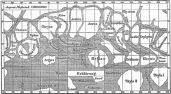
Giovanni Virginio Schiaparelli was an Italian astronomer and science historian.

<span class="mw-page-title-main">Syrtis Major Planum</span> Martian volcano

Syrtis Major Planum is a "dark spot" located in the boundary between the northern lowlands and southern highlands of Mars just west of the impact basin Isidis in the Syrtis Major quadrangle. It was discovered, on the basis of data from Mars Global Surveyor, to be a low-relief shield volcano, but was formerly believed to be a plain, and was then known as Syrtis Major Planitia. The dark color comes from the basaltic volcanic rock of the region and the relative lack of dust.

<span class="mw-page-title-main">Areography</span> Delineation and characterization of Martian regions

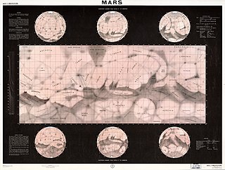
Areography, also known as the geography of Mars, is a subfield of planetary science that entails the delineation and characterization of regions on Mars. Areography is mainly focused on what is called physical geography on Earth; that is the distribution of physical features across Mars and their cartographic representations. In April 2023, The New York Times reported an updated global map of Mars based on images from the Hope spacecraft. A related, but much more detailed, global Mars map was released by NASA on 16 April 2023.

<span class="mw-page-title-main">Martian canals</span> Erroneous idea of canals on Mars

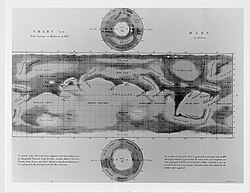
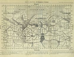
During the late 19th and early 20th centuries, it was erroneously believed that there were "canals" on the planet Mars. These were a network of long straight lines in the equatorial regions from 60° north to 60° south latitude on Mars, observed by astronomers using early telescopes without photography.

<span class="mw-page-title-main">Ascraeus Mons</span> Martian volcano

Ascraeus Mons is a large shield volcano located in the Tharsis region of the planet Mars. It is the northernmost and tallest of three shield volcanoes collectively known as the Tharsis Montes.

<span class="mw-page-title-main">Albedo feature</span> Region of a planets surface which contrasts in brightness to its surroundings

In planetary geology, an albedo feature is a large area on the surface of a planet which shows a contrast in brightness or darkness (albedo) with adjacent areas.

<span class="mw-page-title-main">Tharsis Montes</span> Montes on Mars

The Tharsis Montes are three large shield volcanoes in the Tharsis region of the planet Mars. From north to south, the volcanoes are Ascraeus Mons, Pavonis Mons and Arsia Mons. Mons is the Latin word for mountain; it is a descriptor term used in astrogeology for mountainous features in the Solar System.

<span class="mw-page-title-main">Schiaparelli (Martian crater)</span> Crater on Mars

Schiaparelli is an impact crater on Mars, located near the planet's equator at latitude 3° south and longitude 344° in the Sinus Sabaeus quadrangle. It measures approximately 459 kilometers (285-miles) in diameter and was named after Italian astronomer Giovanni Schiaparelli, known for his observations of the Red Planet and his mistranslated term "canali". The name was adopted by IAU's Working Group for Planetary System Nomenclature in 1973.

<span class="mw-page-title-main">Dark slope streak</span> Surface feature of Mars

Dark slope streaks are narrow, avalanche-like features common on dust-covered slopes in the equatorial regions of Mars. They form in relatively steep terrain, such as along escarpments and crater walls. Although first recognized in Viking Orbiter images from the late 1970s, dark slope streaks were not studied in detail until higher-resolution images from the Mars Global Surveyor (MGS) and Mars Reconnaissance Orbiter (MRO) spacecraft became available in the late 1990s and 2000s.

<span class="mw-page-title-main">History of Mars observation</span> History of observations of the planet Mars

The history of Mars observation is about the recorded history of observation of the planet Mars. Some of the early records of Mars' observation date back to the era of the ancient Egyptian astronomers in the 2nd millennium BCE. Chinese records about the motions of Mars appeared before the founding of the Zhou dynasty. Detailed observations of the position of Mars were made by Babylonian astronomers who developed arithmetic techniques to predict the future position of the planet. The ancient Greek philosophers and Hellenistic astronomers developed a geocentric model to explain the planet's motions. Measurements of Mars' angular diameter can be found in ancient Greek and Indian texts. In the 16th century, Nicolaus Copernicus proposed a heliocentric model for the Solar System in which the planets follow circular orbits about the Sun. This was revised by Johannes Kepler, yielding an elliptic orbit for Mars that more accurately fitted the observational data.

<span class="mw-page-title-main">Martian surface</span> Mars science studying the characteristics of the materials present at the Martian surface

The study of surface characteristics is a broad category of Mars science that examines the nature of the materials making up the Martian surface. The study evolved from telescopic and remote-sensing techniques developed by astronomers to study planetary surfaces. However, it has increasingly become a subdiscipline of geology as automated spacecraft bring ever-improving resolution and instrument capabilities. By using characteristics such as color, albedo, and thermal inertia and analytical tools such as reflectance spectroscopy and radar, scientists are able to study the chemistry and physical makeup of the Martian surface. The resulting data help scientists understand the planet's mineral composition and the nature of geological processes operating on the surface. Mars’ surface layer represents a tiny fraction of the total volume of the planet, yet plays a significant role in the planet's geologic history. Understanding physical surface properties is also very important in determining safe landing sites for spacecraft.

<span class="mw-page-title-main">Collis (planetary nomenclature)</span>

Collis is a small hill or knob on a celestial body. The term is used in planetary nomenclature: it is a part of international proper names of such features. Like other generic terms, it is capitalized and stands after the proper name. As of 2015, only groups of the hills have names, and the term is used only in plural.

The following outline is provided as an overview of and topical guide to Mars:

<span class="mw-page-title-main">Nili Patera dune field</span> Martian dune field

Nili Patera is a dune field on Mars. It is located on top of a lava bed, at the site of an ancient volcano, the Nili Patera caldera of Syrtis Major, near the Martian equator, and it is one of the most active dune fields of Mars. Its location coordinates on Mars are 8.7° N latitude, 67.3° E longitude. It is being actively studied by the HiRISE camera, on board the Mars Reconnaissance Orbiter, at the rate of one image every six weeks. The study of the movement of the dunes provides information regarding wind variation as a function of time and furthers the study of surface erosion characteristics of the Martian landscape. This information can then be used for the development and design of future Mars expeditions. The dunes of the Patera field are of the barchan type and their study by HiRISE was the first one to establish dune and ripple movement of a minimum of 1 metre on Mars. The Patera dune field, was also the first to be investigated using the COSI-Corr software, which was originally developed to analyse the movement of earthbound dunes. The research results from the evidence provided by the monitoring of the Nili Patera field, indicate sand fluxes of the order of several cubic metres per metre per year, similar to the flux observed at the sand dunes of Victoria Valley in Antarctica.

<span class="mw-page-title-main">Abalos Undae</span> Martian dune field

Abalos Undae is a dune field on Mars in the periphery of Planum Boreum, the Martian North pole. It is one of the officially named northern circumpolar dune fields, along with Olympia, Hyperboreae, and Siton Undae, and also one of the densest of the region. Its northernmost boundary is located in the southwest channel that separates the Abalos Colles formation from the main polar ice cap, and from there the dune field extends southwest all the way to the lowlands of Vastitas Borealis.

<span class="mw-page-title-main">Siton Undae</span> Martian dune field

Siton Undae is one of the largest and densest dune fields in the vicinity of Planum Boreum, the Martian northern polar ice-cap. It is named after one of the classical albedo features on Mars. Its name was officially approved by IAU on 20 March 2007. It extends from latitude 73.79°N to 77.5°N and from longitude 291.38°E to 301.4°E. Its centre is located at latitude 75.55°N, longitude 297.28E (62.72°W), and has a diameter of 222.97 kilometres (138.55 mi).

<span class="mw-page-title-main">Ogygis Undae</span> Martian dune field

Ogygis Undae is the only named southern hemisphere dune field on Mars. It is named after one of the classical albedo features on Mars, Ogygis Regio. Its name, which refers to Ogyges, a primeval mythological ruler in ancient Greece, was officially approved by the International Astronomical Union (IAU) on September 17, 2015. It is situated just outside Argyre Planitia, a plain located in the southern highlands of Mars. The dunes of Ogygis Undae extend from latitude −49.94°N to −49.37°N and from longitude 292.64°E to 294.93°E. They are centered at latitude −49.66°N, longitude 293.79°E (66.21°W), and extend approximately 87 km to the east and west from there. Ogygis Undae has an area of 1904 km2, and due to its large size is a primary subject for research on Martian dune morphology and sand composition.

References

  1. "History of Planetary Nomenclature". planetarynames.wr.usgs.gov. International Astronomical Union (IAU) Working Group for Planetary System Nomenclature (WGPSN). Retrieved 3 Dec 2016.
  2. "Martian Feature Name Nomenclature". www.marsartgallery.com. Retrieved 3 Dec 2016.
  3. United States Geological Survey Astrogeology Program, "Mars Nomenclature: Albedo Feature", Gazetteer of Planetary Nomenclature [ permanent dead link ].
  4. Frey, Herbert (1974). "Surface Features on Mars: Ground-Based Albedo and Radar Compared With Mariner 9 Topography". Journal of Geophysical Research. Journal of Geophysical Research. 79 (26): 3907–3916. Bibcode:1974JGR....79.3907F. doi:10.1029/JB079i026p03907. hdl: 2060/19740005454 . Archived from the original on January 16, 2014.

Further reading