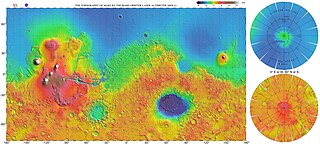
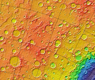
MOLA colorized relief map of Hesperia Planum, the type area for the Hesperian System. Note that Hesperia Planum has fewer large impact craters than the surrounding Noachian terrain, indicating a younger age. Colors indicate elevation, with red highest, yellow intermediate, and green/blue lowest.
The Hesperian is a geologic system and time period on the planet Mars characterized by widespread volcanic activity and catastrophic flooding that carved immense outflow channels across the surface. The Hesperian is an intermediate and transitional period of Martian history. During the Hesperian, Mars changed from the wetter and perhaps warmer world of the Noachian to the dry, cold, and dusty planet seen today.[1] The absolute age of the Hesperian Period is uncertain. The beginning of the period followed the end of the Late Heavy Bombardment[2] and probably corresponds to the start of the lunar Late Imbrian period,[3][4] around 3700 million years ago (Mya). The end of the Hesperian Period is much more uncertain and could range anywhere from 3200 to 2000 Mya,[5] with 3000 Mya being frequently cited. The Hesperian Period is roughly coincident with the Earth's early Archean Eon.[2]
By the beginning of the Late Hesperian the atmosphere had probably thinned to its present density.[10] As the planet cooled, groundwater stored in the upper crust (megaregolith) began to freeze, forming a thick cryosphere overlying a deeper zone of liquid water.[11] Subsequent volcanic or tectonic activity occasionally fractured the cryosphere, releasing enormous quantities of deep groundwater to the surface and carving huge outflow channels. Much of this water flowed into the northern hemisphere where it probably pooled to form large transient lakes or an ice covered ocean.
Description and name origin
The Hesperian System and Period is named after Hesperia Planum, a moderately cratered highland region northeast of the Hellas basin. The type area of the Hesperian System is in the Mare Tyrrhenum quadrangle (MC-22) around 20°S245°W / 20°S 245°W / -20; -245. The region consists of rolling, wind-streaked plains with abundant wrinkle ridges resembling those on the lunar maria. These "ridged plains" are interpreted to be basaltic lava flows (flood basalts) that erupted from fissures.[12] The number-density of large impact craters is moderate, with about 125–200 craters greater than 5km in diameter per million km2.[3][13] Hesperian-aged ridged plains cover roughly 30% of the Martian surface;[2] they are most prominent in Hesperia Planum, Syrtis Major Planum, Lunae Planum, Malea Planum, and the Syria-Solis-Sinai Plana in southern Tharsis.[14][15]
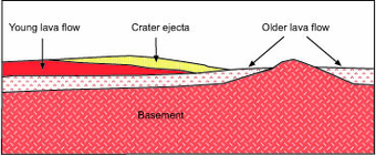
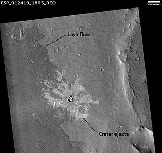
Schematic cross section of image at left. Surface units are interpreted as a sequence of layers (strata), with the youngest at top and oldest at bottom in accordance with the law of superposition.HiRISE image illustrating superpositioning, a principle that lets geologists determine the relative ages of surface units. The dark-toned lava flow overlies (is younger than) the light-toned, more heavily cratered terrain at right. The ejecta of the crater at center overlies both units, indicating that the crater is the youngest feature in the image. (See cross section, above right.)
Martian time periods are based on geologic mapping of surface units from spacecraft images.[12][16] A surface unit is a terrain with a distinct texture, color, albedo, spectral property, or set of landforms that distinguish it from other surface units and is large enough to be shown on a map.[17] Mappers use a stratigraphic approach pioneered in the early 1960s for photogeologic studies of the Moon.[18] Although based on surface characteristics, a surface unit is not the surface itself or group of landforms. It is an inferredgeologic unit (e.g., formation) representing a sheetlike, wedgelike, or tabular body of rock that underlies the surface.[19][20] A surface unit may be a crater ejecta deposit, lava flow, or any surface that can be represented in three dimensions as a discrete stratum bound above or below by adjacent units (illustrated right). Using principles such as superpositioning (illustrated left), cross-cutting relationships, and the relationship of impact crater density to age, geologists can place the units into a relative age sequence from oldest to youngest. Units of similar age are grouped globally into larger, time-stratigraphic (chronostratigraphic) units, called systems. For Mars, four systems are defined: the Pre-Noachian, Noachian, Hesperian, and Amazonian. Geologic units lying below (older than) the Noachian are informally designated Pre-Noachian.[21] The geologic time (geochronologic) equivalent of the Hesperian System is the Hesperian Period. Rock or surface units of the Hesperian System were formed or deposited during the Hesperian Period.
smaller than an age/stage; not used by the ICS timescale
System and period are not interchangeable terms in formal stratigraphic nomenclature, although they are frequently confused in popular literature. A system is an idealized stratigraphic column based on the physical rock record of a type area (type section) correlated with rocks sections from many different locations planetwide.[23] A system is bound above and below by strata with distinctly different characteristics (on Earth, usually index fossils) that indicate dramatic (often abrupt) changes in the dominant fauna or environmental conditions. (See Cretaceous–Paleogene boundary as example.)
At any location, rock sections in a given system are apt to contain gaps (unconformities) analogous to missing pages from a book. In some places, rocks from the system are absent entirely due to nondeposition or later erosion. For example, rocks of the Cretaceous System are absent throughout much of the eastern central interior of the United States. However, the time interval of the Cretaceous (Cretaceous Period) still occurred there. Thus, a geologic period represents the time interval over which the strata of a system were deposited, including any unknown amounts of time present in gaps.[23] Periods are measured in years, determined by radioactive dating. On Mars, radiometric ages are not available except from Martian meteorites whose provenance and stratigraphic context are unknown. Instead, absolute ages on Mars are determined by impact crater density, which is heavily dependent upon models of crater formation over time.[24] Accordingly, the beginning and end dates for Martian periods are uncertain, especially for the Hesperian/Amazonian boundary, which may be in error by a factor of 2 or 3.[4][21]
Boundaries and subdivisions
Geologic contact of Noachian and Hesperian Systems. Hesperian ridged plains (Hr) embay and overlie older Noachian cratered plateau materials (Npl). The ridged plains partially bury many of the old Noachian-aged craters. Image is THEMIS IR mosaic, based on similar Viking photo shown in Tanaka et al. (1992), Fig. 1a, p. 352.Approximate geologic contact of Upper Hesperian lava apron from Alba Mons (Hal) with Lower Amazonian Vastitas Borealis Formation (Avb). Image is MOLA topographic map adapted from Ivanov and Head (2006), Figs. 1, 3, and 8.
The lower boundary of the Hesperian System is defined as the base of the ridged plains, which are typified by Hesperia Planum and cover about a third of the planet's surface.[3] In eastern Hesperia Planum, the ridged plains overlie early to mid Noachian aged cratered plateau materials (pictured left).[15] The Hesperian's upper boundary is more complex and has been redefined several times based on increasingly detailed geologic mapping.[3][12][26] Currently, the stratigraphic boundary of the Hesperian with the younger Amazonian System is defined as the base of the Vastitas Borealis Formation[27] (pictured right). The Vastitas Borealis is a vast, low-lying plain that covers much of the northern hemisphere of Mars. It is generally interpreted to consist of reworked sediments originating from the Late Hesperian outflow channels and may be the remnant of an ocean that covered the northern lowland basins. Another interpretation of the Vastitas Borealis Formation is that it consists of lava flows.[28]
The Hesperian System is subdivided into two chronostratigraphic series: Lower Hesperian and Upper Hesperian. The series are based on referents or locations on the planet where surface units indicate a distinctive geological episode, recognizable in time by cratering age and stratigraphic position. For example, Hesperia Planum is the referent location for the Lower Hesperian Series.[3][29] The corresponding geologic time (geochronological) units of the two Hesperian series are the Early Hesperian and Late Hesperian Epochs. An epoch is a subdivision of a period; the two terms are not synonymous in formal stratigraphy. The age of the Early Hepserian/Late Hesperian boundary is uncertain, ranging from 3600 to 3200 million years ago based on crater counts.[5] The average of the range is shown in the timeline below.
Stratigraphic terms are typically confusing to geologists and non-geologists alike. One way to sort through the difficulty is by the following example: One could easily go to Cincinnati, Ohio and visit a rock outcrop in the Upper OrdovicianSeries of the Ordovician System. You could even collect a fossil trilobite there. However, you could not visit the Late Ordovician Epoch in the Ordovician Period and collect an actual trilobite.
The Earth-based scheme of rigid stratigraphic nomenclature has been successfully applied to Mars for several decades now but has numerous flaws. The scheme will no doubt become refined or replaced as more and better data become available.[30] (See mineralogical timeline below as example of alternative.) Obtaining radiometric ages on samples from identified surface units is clearly necessary for a more complete understanding of Martian chronology.[31]
Mars during the Hesperian Period
Viking orbiter view of Hesperian-aged surface in Terra Meridiani. The small impact craters date back to the Hesperian Period and appear crisp despite their great age. This image indicates that erosion on Mars has been very slow since the end of the Noachian. Image is 17 km across and based on Carr, 1996, p. 134, Fig. 6-8.
The Hesperian was a time of declining rates of impact cratering, intense and widespread volcanic activity, and catastrophic flooding. Many of the major tectonic features on Mars formed at this time. The weight of the immense Tharsis Bulge stressed the crust to produce a vast network of extensional fractures (fossae) and compressive deformational features (wrinkle ridges) throughout the western hemisphere. The huge equatorial canyon system of Valles Marineris formed during the Hesperian as a result of these stresses. Sulfuric-acid weathering at the surface produced an abundance of sulfate minerals that precipitated in evaporitic environments, which became widespread as the planet grew increasingly arid. The Hesperian Period was also a time when the earliest evidence of glacial activity and ice-related processes appears in the Martian geologic record.
Impact cratering
As originally conceived, the Hesperian System referred to the oldest surfaces on Mars that postdate the end of heavy bombardment.[33] The Hesperian was thus a time period of rapidly declining impact cratering rates. However, the timing and rate of the decline are uncertain. The lunar cratering record suggests that the rate of impacts in the inner Solar System during the Noachian (4000million years ago) was 500 times higher than today.[34] Planetary scientists still debate whether these high rates represent the tail end of planetary accretion or a late cataclysmic pulse that followed a more quiescent period of impact activity. Nevertheless, at the beginning of the Hesperian, the impact rate had probably declined to about 80 times greater than present rates,[4] and by the end of the Hesperian, some 700 million years later, the rate began to resemble that seen today.[35]
↑ Head, J.W.; Wilson, L. (2011). The Noachian-Hesperian Transition on Mars: Geological Evidence for a Punctuated Phase of Global Volcanism as a Key Driver in Climate and Atmospheric Evolution. 42nd Lunar and Planetary Science Conference (2011), Abstract #1214. http://www.lpi.usra.edu/meetings/lpsc2011/pdf/1214.pdf.
↑ Clifford, S. M. (1993). "A model for the hydrologic and climatic behavior of water on Mars". Journal of Geophysical Research. 98 (E6): 10973–11016. Bibcode:1993JGR....9810973C. doi:10.1029/93JE00225.
1 2 3 Scott, D.H.; Carr, M.H. (1978). Geologic Map of Mars. U.S. Geological Survey Miscellaneous Investigations Series Map I-1083.
↑ Strom, R.G.; Croft, S.K.; Barlow, N.G. (1992) The Martian Impact Cratering Record in Mars, H.H. Kieffer et al., Eds.; University of Arizona Press: Tucson, AZ, pp. 383–423.
↑ Scott, D.H.; Tanaka, K.L. (1986). Geologic Map of the Western Equatorial Region of Mars. U.S. Geological Survey Miscellaneous Investigations Series Map I–1802–A.
1 2 Greeley, R.; Guest, J.E. (1987). Geologic Map of the Eastern Equatorial Region of Mars. U.S. Geological Survey Miscellaneous Investigations Series Map I–1802–B.
↑ McCord, T.M. et al. (1980). Definition and Characterization of Mars Global Surface Units: Preliminary Unit Maps. 11th Lunar and Planetary Science Conference: Houston: TX, abstract #1249, pp. 697–699. http://www.lpi.usra.edu/meetings/lpsc1980/pdf/1249.pdf.
↑ Greeley, R. (1994) Planetary Landscapes, 2nd ed.; Chapman & Hall: New York, p. 8 and Fig. 1.6.
↑ See Mutch, T.A. (1970). Geology of the Moon: A Stratigraphic View; Princeton University Press: Princeton, NJ, 324 pp. and Wilhelms, D.E. (1987). The Geologic History of the Moon, USGS Professional Paper 1348; http://ser.sese.asu.edu/GHM/ for reviews of this topic.
↑ Wilhelms, D.E. (1990). Geologic Mapping in Planetary Mapping, R. Greeley, R.M. Batson, Eds.; Cambridge University Press: Cambridge UK, p. 214.
↑ Tanaka, K.L.; Scott, D.H.; Greeley, R. (1992). Global Stratigraphy in Mars, H.H. Kieffer et al., Eds.; University of Arizona Press: Tucson, AZ, pp. 345–382.
↑ Tanaka, K.L.; Skinner, J.A.; Hare, T.M. (2005). Geologic Map of the Northern Plains of Mars. Scientific Investigations Map 2888, Pamphlet; U.S. Geological Survey.
↑ The Vastitas Borealis Formation is used here to include the Lower Amazonian Scandia, Vastitas Borealis interior, and Vastitas Borealis marginal units of Tanaka et al. (2005).
↑ Catling, D.C.; Leovy, C.B.; Wood, S.E.; Day, M.D. (2011). A Lava Sea in the Northern Plains of Mars: Circumpolar Hesperian Oceans Reconsidered. 42nd Lunar and Planetary Science Conference, Abstract #2529. http://www.lpi.usra.edu/meetings/lpsc2011/pdf/2529.pdf.
Alba Mons is a volcano located in the northern Tharsis region of the planet Mars. It is the biggest volcano on Mars in terms of surface area, with volcanic flow fields that extend for at least 1,350 km (840 mi) from its summit. Although the volcano has a span comparable to that of the United States, it reaches an elevation of only 6.8 km (22,000 ft) at its highest point. This is about one-third the height of Olympus Mons, the tallest volcano on the planet. The flanks of Alba Mons have very gentle slopes. The average slope along the volcano's northern flank is 0.5°, which is over five times lower than the slopes on the other large Tharsis volcanoes. In broad profile, Alba Mons resembles a vast but barely raised welt on the planet's surface. It is a unique volcanic structure with no counterpart on Earth or elsewhere on Mars.
Holden is a 140 km wide crater situated within the Margaritifer Sinus quadrangle (MC-19) region of the planet Mars, located with the southern highlands. It is named after American astronomer Edward Singleton Holden. It is part of the Uzboi-Landon-Morava (ULM) system.
The North Polar Basin, more commonly known as the Borealis Basin, is a large basin in the northern hemisphere of Mars that covers 40% of the planet. Some scientists have postulated that the basin formed during the impact of a single, large body roughly 2% of the mass of Mars, having a diameter of about 1,900 km early in the history of Mars, around 4.5 billion years ago. However, the basin is not currently recognized as an impact basin by the IAU. The basin is one of the flattest areas in the Solar System, and has an elliptical shape.
Eberswalde, formerly known as Holden NE, is a partially buried impact crater in Margaritifer Terra, Mars. Eberswalde crater lies just to the north of Holden, a large crater that may have been a lake. The 65.3-km-diameter crater, centered at 24°S, 33°W, is named after the German town of the same name, in accordance with the International Astronomical Union's rules for planetary nomenclature. It was one of the final four proposed landing sites for the Mars rover Mars Science Laboratory mission. This extraterrestrial geological feature lies situated within the Margaritifer Sinus quadrangle (MC-19) region of Mars. Although not chosen, it was considered a potential landing site for the Mars 2020 Perseverance rover, and in the second Mars 2020 Landing Site Workshop it survived the cut and was among the top eight sites still in the running.
The geology of Mars is the scientific study of the surface, crust, and interior of the planet Mars. It emphasizes the composition, structure, history, and physical processes that shape the planet. It is analogous to the field of terrestrial geology. In planetary science, the term geology is used in its broadest sense to mean the study of the solid parts of planets and moons. The term incorporates aspects of geophysics, geochemistry, mineralogy, geodesy, and cartography. A neologism, areology, from the Greek word Arēs (Mars), sometimes appears as a synonym for Mars's geology in the popular media and works of science fiction. The term areology is also used by the Areological Society.
Olympia Undae is a vast dune field in the north polar region of the planet Mars. It consists of a broad "sand sea" or erg that partly rings the north polar plateau from about 120° to 240°E longitude and 78° to 83°N latitude. Stretching about 1,100 km (680 mi) across and covering an area of 470,000 km2, Olympia Undae is the largest continuous dune field on Mars. It is similar in size to the Rub' Al Khali in the Arabian Peninsula, the largest active erg on Earth.
The Phlegra Montes are a system of eroded Hesperian–Noachian-aged massifs and knobby terrain in the mid-latitudes of the northern lowlands of Mars, extending northwards from the Elysium Rise towards Vastitas Borealis for nearly 1,400 km (870 mi). The mountain ranges separate the large plains provinces of Utopia Planitia (west) and Amazonis Planitia (east), and were named in the 1970s after a classical albedo feature. The massif terrains are flanked by numerous parallel wrinkle ridges known as the Phlegra Dorsa.
Enipeus Vallis is a valley in the northern hemisphere of the planet Mars. It is centered at lat. 37°N, long. 267°E in the Arcadia quadrangle (MC-3) between the large volcano Alba Mons and the Tempe Terra plateau. The valley follows a gently sinuous, north-south path for a distance of about 357 km (222 mi). It is likely an ancient watercourse that formed during the early Hesperian period, around 3.7 billion years ago.
Denning Crater is a large Noachian-age impact crater in the southwestern Terra Sabaea region of the southern Martian highlands, within the Sinus Sabaeus quadrangle. It is located to the northwest of the Hellas impact basin within the furthest outskirts of the Hellas debris apron. The crater is 165 km in diameter and likely formed during the Late Heavy Bombardment, a period of intense bolide impacts affecting the entirety of the Solar System; during the Hesperian period, aeolian processes caused significant degradation of the crater's rim features and infilled the crater's floor. Similar to other large craters in this region of Mars, wind-eroded features are sporadically found on the basin floor. The presence of wrinkle ridges of varying orientations within and around the Denning basin has been correlated to regional tectonic events, including the formation of the Hellas basin itself. The crater was named for British astronomer William Frederick Denning.
The Noachian is a geologic system and early time period on the planet Mars characterized by high rates of meteorite and asteroid impacts and the possible presence of abundant surface water. The absolute age of the Noachian period is uncertain but probably corresponds to the lunar Pre-Nectarian to Early Imbrian periods of 4100 to 3700 million years ago, during the interval known as the Late Heavy Bombardment. Many of the large impact basins on the Moon and Mars formed at this time. The Noachian Period is roughly equivalent to the Earth's Hadean and early Archean eons when Earth's first life forms likely arose.
Hesperia Planum is a broad lava plain in the southern highlands of the planet Mars. The plain is notable for its moderate number of impact craters and abundant wrinkle ridges. It is also the location of the ancient volcano Tyrrhena Mons. The Hesperian time period on Mars is named after Hesperia Planum.
Rain and snow was a regular occurrence on Mars in the past; especially in the Noachian and early Hesperian epochs. Water was theorized to seep into the ground until it reached a formation that would not allow it to penetrate further. Water then accumulated forming a saturated layer. Deep aquifers may still exist.
The geological history of Mars follows the physical evolution of Mars as substantiated by observations, indirect and direct measurements, and various inference techniques. Methods dating back to 17th-century techniques developed by Nicholas Steno, including the so-called law of superposition and stratigraphy, used to estimate the geological histories of Earth and the Moon, are being actively applied to the data available from several Martian observational and measurement resources. These include landers, orbiting platforms, Earth-based observations, and Martian meteorites.
The Amazonian is a geologic system and time period on the planet Mars characterized by low rates of meteorite and asteroid impacts and by cold, hyperarid conditions broadly similar to those on Mars today. The transition from the preceding Hesperian period is somewhat poorly defined. The Amazonian is thought to have begun around 3 billion years ago, although error bars on this date are extremely large. The period is sometimes subdivided into the Early, Middle, and Late Amazonian. The Amazonian continues to the present day.
A low-aspect-ratio layered ejecta crater is a class of impact crater found on the planet Mars. This class of impact craters was discovered by Northern Arizona University scientist Professor Nadine Barlow and Dr. Joseph Boyce from the University of Hawaii in October 2013. Barlow described this class of craters as having a "thin-layered outer deposit" surpassing "the typical range of ejecta". "The combination helps vaporize the materials and create a base flow surge. The low aspect ratio refers to how thin the deposits are relative to the area they cover", Barlow said. The scientists used data from continuing reconnaissance of Mars using the old Mars Odyssey orbiter and the Mars Reconnaissance Orbiter. They discovered 139 LARLE craters ranging in diameter from 1.0 to 12.2 km, with 97% of the LARLE craters found poleward of 35N and 40S. The remaining 3% mainly traced in the equatorial Medusae Fossae Formation.
Hargraves is a Hesperian-age complex double-layered ejecta impact crater on Mars. It was emplaced near the crustal dichotomy in the vicinity of the Nili Fossae, the Syrtis Major volcanic plains, and the Isidis impact basin, and is situated within the Syrtis Major quadrangle. Hargraves has been the target of focused study because its ejecta apron is particularly well-preserved for a Martian crater of its size. It has been analogized to similar double-layered ejecta blankets on Earth, including that of the Ries impact structure, which was where the conceptual model for how such craters formed was first advanced.
Rupes Tenuis is a Martian north polar scarp. It is named after one of the classical albedo features on Mars. Its name was officially approved by IAU in 1988. It extends from latitude 74.94°N to 82.2°N and from longitude 242.12°E to 300.77°E. Its centre is located at latitude 81.6°N longitude 85.47°W. It marks the outer perimeter of Planum Boreum from longitude 242.12°E to 300.77°E, and it is formed by the eastern extension of the Olympia Cavi, a series of local troughs and depressions, which become longer and deeper as they merge to create the Rupes Tenuis scarp formation. The scarp is located to the west of Chasma Boreale, at the base of Planum Boreum, and its height varies from a few hundred metres to a maximum of approximately 1000 metres.
Siton Undae is one of the largest and densest dune fields in the vicinity of Planum Boreum, the Martian northern polar ice-cap. It is named after one of the classical albedo features on Mars. Its name was officially approved by IAU on 20 March 2007. It extends from latitude 73.79°N to 77.5°N and from longitude 291.38°E to 301.4°E. Its centre is located at latitude 75.55°N, longitude 297.28E (62.72°W), and has a diameter of 222.97 kilometres (138.55 mi).
Abalos Colles is a stratified fragment of the Rupes Tenuis basal unit of Planum Boreum, located south of the Rupes Tenuis scarp and west of the Escorial crater. It contains 16 mounds. Abalos Colles is one of the named features in the vicinity of Planum Boreum, the Martian North pole. It is named after one of the classical albedo features on Mars located at latitude 72°N, longitude 70°W. Its name was officially approved by the International Astronomical Union (IAU) in 2003.
The Pre-Noachian is a geologic system and early time period on the planet Mars characterized by intense meteorite and asteroid impacts, volcanic and tectonic activity, and the potential existence of surface or subsurface water. This era represents a crucial phase in Mars' history, witnessing the planet's formation, and the shaping of its geological landscape. However, the Pre-Noachian period remains elusive, being the least understood among Mars' four geological phases. Erosion and deposition have obscured much of the evidence from this time period on Mars.
This page is based on this Wikipedia article Text is available under the CC BY-SA 4.0 license; additional terms may apply. Images, videos and audio are available under their respective licenses.