Areography

Last updated
High-resolution colorized map of Mars based on Viking orbiter images. Surface frost and water ice fog brighten the impact basin Hellas to the right of lower center; Syrtis Major just above it is darkened by winds that sweep dust off its basaltic surface. Residual north and south polar ice caps are shown at upper and lower right as they appear in early summer and at minimum size, respectively. Mars Viking MDIM21 1km plus poles.jpg
High-resolution colorized map of Mars based on Viking orbiter images. Surface frost and water ice fog brighten the impact basin Hellas to the right of lower center; Syrtis Major just above it is darkened by winds that sweep dust off its basaltic surface. Residual north and south polar ice caps are shown at upper and lower right as they appear in early summer and at minimum size, respectively.

Areography, also known as the geography of Mars, is a subfield of planetary science that entails the delineation and characterization of regions on Mars. [1] [2] [3] Areography is mainly focused on what is called physical geography on Earth; that is the distribution of physical features across Mars and their cartographic representations. In April 2023, The New York Times reported an updated global map of Mars based on images from the Hope spacecraft. [4] A related, but much more detailed, global Mars map was released by NASA on 16 April 2023. [5]

Contents

History

Map of Mars by Giovanni Schiaparelli. North is at the top of this map; however, in most maps of Mars drawn before space exploration the convention among astronomers was to put south at the top because the telescopic image of a planet is inverted. Karte Mars Schiaparelli MKL1888.png
Map of Mars by Giovanni Schiaparelli. North is at the top of this map; however, in most maps of Mars drawn before space exploration the convention among astronomers was to put south at the top because the telescopic image of a planet is inverted.

The first detailed observations of Mars were from ground-based telescopes. The history of these observations are marked by the oppositions of Mars, when the planet is closest to Earth and hence is most easily visible, which occur every couple of years. Even more notable are the perihelic oppositions of Mars which occur approximately every 16 years, and are distinguished because Mars is closest to earth and Jupiter perihelion making it even closer to Earth.

In September 1877, (a perihelic opposition of Mars occurred on September 5), Italian astronomer Giovanni Schiaparelli published the first detailed map of Mars. These maps notably contained features he called canali ("channels"), that were later shown to be an optical illusion. These canali were supposedly long straight lines on the surface of Mars to which he gave names of famous rivers on Earth. His term was popularly mistranslated as canals, and so started the Martian canal controversy.

Following these observations, it was a long-held belief that Mars contained vast seas and vegetation. It was not until spacecraft visited the planet during NASA's Mariner missions in the 1960s that these myths were dispelled. Some maps of Mars were made using the data from these missions, but it wasn't until the Mars Global Surveyor mission, launched in 1996 and ending in late 2006, that complete, extremely detailed maps were obtained.

Cartography

Cartography is the art, science, and technology of making maps. There are many established techniques specific to Earth that allow us to convert the 2D curved surface into 2D planes to facilitate mapping. To facilitate this on Mars, projections, coordinate systems, and datums needed to be established. Today, the United States Geological Survey defines thirty cartographic quadrangles for the surface of Mars. These can be seen below.

MGS MOC Wide Angle Map of Mars PIA03467.jpg
0°N180°W / 0°N 180°W / 0; -180
MGS MOC Wide Angle Map of Mars PIA03467.jpg
Interactive icon.svg Clickable image of the 30 cartographic quadrangles of Mars, defined by the USGS. [6] [9] Quadrangle numbers (beginning with MC for "Mars Chart") [10] and names link to the corresponding articles. North is at the top; 0°N180°W / 0°N 180°W / 0; -180 is at the far left on the equator. The map images were taken by the Mars Global Surveyor.
()


Zero elevation

On Earth, the zero elevation datum is based on sea level (the geoid). Since Mars has no oceans and hence no 'sea level', it is convenient to define an arbitrary zero-elevation level or "vertical datum" for mapping the surface, called areoid . [11]

The datum for Mars was defined initially in terms of a constant atmospheric pressure. From the Mariner 9 mission up until 2001, this was chosen as 610.5 Pa (6.105 mbar), on the basis that below this pressure liquid water can never be stable (i.e., the triple point of water is at this pressure). This value is only 0.6% of the pressure at sea level on Earth. Note that the choice of this value does not mean that liquid water does exist below this elevation, just that it could were the temperature to exceed 273.16 K (0.01 degrees C, 32.018 degrees F). [12]

In 2001, Mars Orbiter Laser Altimeter data led to a new convention of zero elevation defined as the equipotential surface (gravitational plus rotational) whose average value at the equator is equal to the mean radius of the planet. [13]

Zero meridian

Airy-0 crater (27 October 2021) PIA25090-Mars-Airy-0-Crater-20220121.jpg
Airy-0 crater (27 October 2021)

Mars's equator is defined by its rotation, but the location of its prime meridian was specified, as is Earth's, by choice of an arbitrary point which later observers accepted. The German astronomers Wilhelm Beer and Johann Heinrich Mädler selected a small circular feature in the Sinus Meridiani ('Middle Bay' or 'Meridian Bay') as a reference point when they produced the first systematic chart of Mars features in 1830–1832. In 1877, their choice was adopted as the prime meridian by the Italian astronomer Giovanni Schiaparelli when he began work on his notable maps of Mars. In 1909 ephemeris-makers decided that it was more important to maintain continuity of the ephemerides as a guide to observations and this definition was "virtually abandoned". [14] [15]

After the Mariner spacecraft provided extensive imagery of Mars, in 1972 the Mariner 9 Geodesy / Cartography Group proposed that the prime meridian pass through the center of a small 500 m diameter crater (named Airy-0), located in Sinus Meridiani along the meridian line of Beer and Mädler, thus defining 0.0° longitude with a precision of 0.001°. [14] This model used the planetographic control point network developed by Merton Davies of the RAND Corporation. [16]

As radiometric techniques increased the precision with which objects could be located on the surface of Mars, the center of a 500 m circular crater was considered to be insufficiently precise for exact measurements. The IAU Working Group on Cartographic Coordinates and Rotational Elements, therefore, recommended setting the longitude of the Viking 1 lander – for which there was extensive radiometric tracking data – as marking the standard longitude of 47.95137° west. This definition maintains the position of the center of Airy-0 at 0° longitude, within the tolerance of current cartographic uncertainties. [17]

Topography

High resolution topographic map of Mars based on the Mars Global Surveyor laser altimeter research led by Maria Zuber and David Smith. North is at the top. Notable features include the Tharsis volcanoes in the west (including Olympus Mons), Valles Marineris to the east of Tharsis, and Hellas basin in the southern hemisphere. Mars MOLA Topography by Fabio Crameri.png
High resolution topographic map of Mars based on the Mars Global Surveyor laser altimeter research led by Maria Zuber and David Smith. North is at the top. Notable features include the Tharsis volcanoes in the west (including Olympus Mons), Valles Marineris to the east of Tharsis, and Hellas basin in the southern hemisphere.
STL 3D model of Mars with 20x elevation exaggeration using data from the Mars Global Surveyor Mars Orbiter Laser Altimeter. Mars elevation.stl
STL 3D model of Mars with 20× elevation exaggeration using data from the Mars Global Surveyor Mars Orbiter Laser Altimeter.
Mars, 2001, with the southern polar ice cap visible on the bottom. Mars Hubble.jpg
Mars, 2001, with the southern polar ice cap visible on the bottom.
North Polar region with icecap. Mars NPArea-PIA00161.jpg
North Polar region with icecap.

Across a whole planet, generalisation is not possible, and the geography of Mars varies considerably. However, the dichotomy of Martian topography is striking: northern plains flattened by lava flows contrast with the southern highlands, pitted and cratered by ancient impacts. The surface of Mars as seen from Earth is consequently divided into two kinds of areas, with differing albedo. The paler plains covered with dust and sand rich in reddish iron oxides were once thought of as Martian 'continents' and given names like Arabia Terra (land of Arabia) or Amazonis Planitia (Amazonian plain). The dark features were thought to be seas, hence their names Mare Erythraeum, Mare Sirenum and Aurorae Sinus. The largest dark feature seen from Earth is Syrtis Major Planum.

The shield volcano, Olympus Mons (Mount Olympus), rises 22 km above the surrounding volcanic plains, and is the highest known mountain on any planet in the solar system. [12] It is in a vast upland region called Tharsis, which contains several large volcanos. See list of mountains on Mars. The Tharsis region of Mars also has the solar system's largest canyon system, Valles Marineris or the Mariner Valley, which is 4,000 km long and 7 km deep. Mars is also scarred by countless impact craters. The largest of these is the Hellas impact basin. See list of craters on Mars.

Mars has two permanent polar ice caps, the northern one located at Planum Boreum and the southern one at Planum Australe.

The difference between Mars's highest and lowest points is nearly 30 km (from the top of Olympus Mons at an altitude of 21.2 km to Badwater Crater at the bottom of the Hellas impact basin at an altitude of 8.2 km below the datum). In comparison, the difference between Earth's highest and lowest points (Mount Everest and the Mariana Trench) is only 19.7 km. Combined with the planets' different radii, this means Mars is nearly three times "rougher" than Earth.

The International Astronomical Union's Working Group for Planetary System Nomenclature is responsible for naming Martian surface features.

Martian dichotomy

Observers of Martian topography will notice a dichotomy between the northern and southern hemispheres. Most of the northern hemisphere is flat, with few impact craters, and lies below the conventional 'zero elevation' level. In contrast, the southern hemisphere is mountains and highlands, mostly well above zero elevation. The two hemispheres differ in elevation by 1 to 3 km. The border separating the two areas is very interesting to geologists.

One distinctive feature is the fretted terrain. [18] It contains mesas, knobs, and flat-floored valleys having walls about a mile high. Around many of the mesas and knobs are lobate debris aprons that have been shown to be rock-covered glaciers. [19]

Other interesting features are the large river valleys and outflow channels that cut through the dichotomy. [20] [21] [22]

The northern lowlands comprise about one-third of the surface of Mars and are relatively flat, with occasional impact craters. The other two-thirds of the Martian surface are the southern highlands. The difference in elevation between the hemispheres is dramatic. Because of the density of impact craters, scientists believe the southern hemisphere to be far older than the northern plains. [23] Much of heavily cratered southern highlands date back to the period of heavy bombardment, the Noachian.

Multiple hypotheses have been proposed to explain the differences. The three most commonly accepted are a single mega-impact, multiple impacts, and endogenic processes such as mantle convection. [20] Both impact-related hypotheses involve processes that could have occurred before the end of the primordial bombardment, implying that the crustal dichotomy has its origins early in the history of Mars.

The giant impact hypothesis, originally proposed in the early 1980s, was met with skepticism due to the impact area's non-radial (elliptical) shape, where a circular pattern would be stronger support for impact by larger object(s). But a 2008 study [24] provided additional research that supports a single giant impact. Using geologic data, researchers found support for the single impact of a large object hitting Mars at approximately a 45-degree angle. Additional evidence analyzing Martian rock chemistry for post-impact upwelling of mantle material would further support the giant impact theory.

Nomenclature

Early nomenclature

Although better remembered for mapping the Moon starting in 1830, Johann Heinrich Mädler and Wilhelm Beer were the first "areographers". They started off by establishing once and for all that most of the surface features were permanent, and pinned down Mars's rotation period. In 1840, Mädler combined ten years of observations and drew the first map of Mars ever made. Rather than giving names to the various markings they mapped, Beer and Mädler simply designated them with letters; Meridian Bay (Sinus Meridiani) was thus feature "a".

Over the next twenty years or so, as instruments improved and the number of observers also increased, various Martian features acquired a hodge-podge of names. To give a couple of examples, Solis Lacus was known as the "Oculus" (the Eye), and Syrtis Major was usually known as the "Hourglass Sea" or the "Scorpion". In 1858, it was also dubbed the "Atlantic Canale" by the Jesuit astronomer Angelo Secchi. Secchi commented that it "seems to play the role of the Atlantic which, on Earth, separates the Old Continent from the New;" this was the first time the fateful canale, which in Italian can mean either "channel" or "canal", had been applied to Mars.

In 1867, Richard Anthony Proctor drew up a map of Mars. It was based, somewhat crudely, on the Rev. William Rutter Dawes' earlier drawings of 1865, then the best ones available. Proctor explained his system of nomenclature by saying, "I have applied to the different features the names of those observers who have studied the physical peculiarities presented by Mars." Here are some of his names, paired with those later used by Schiaparelli in his Martian map created between 1877 and 1886. [25] Schiaparelli's names were generally adopted and are the names actually used today:

Proctor nomenclatureSchiaparelli nomenclature
Kaiser SeaSyrtis Major
Lockyer Land Hellas Planitia
Main Sea Lacus Moeris
Herschel II Strait Sinus Sabaeus
Dawes Continent Aeria and Arabia
De La Rue Ocean Mare Erythraeum
Lockyer Sea Solis Lacus
Dawes Sea Tithonius Lacus
Madler Continent Chryse Planitia, Ophir, Tharsis
Maraldi Sea Maria Sirenum and Cimmerium
Secchi Continent Memnonia
Hooke Sea Mare Tyrrhenum
Cassini Land Ausonia
Herschel I Continent Zephyria, Aeolis, Aethiopis
Hind Land Libya

Proctor's nomenclature has often been criticized, mainly because so many of his names honored English astronomers, but also because he used many names more than once. In particular, Dawes appeared no fewer than six times (Dawes Ocean, Dawes Continent, Dawes Sea, Dawes Strait, Dawes Isle, and Dawes Forked Bay). Even so, Proctor's names are not without charm, and for all their shortcomings they were a foundation on which later astronomers would improve.

Modern nomenclature

Planet Mars - Topographical Map (USGS; 2005) USGS-PlanetMars-TopographicalMap.png
Planet Mars - Topographical Map (USGS; 2005)
Map of Mars.png
Informal names near Curiosity's landing site in contrast with official Herschel crater.

Today, names of Martian features derive from a number of sources, but the names of the large features are derived primarily from the maps of Mars made in 1886 by the Italian astronomer Giovanni Schiaparelli. Schiaparelli named the larger features of Mars primarily using names from Greek mythology and to a lesser extent the Bible. Mars's large albedo features retain many of the older names, but are often updated to reflect new knowledge of the nature of the features. For example, 'Nix Olympica' (the snows of Olympus) has become Olympus Mons (Mount Olympus).

Large Martian craters are named after important scientists and science fiction writers; smaller ones are named after towns and villages on Earth.

Various landforms studied by the Mars Exploration Rovers are given temporary names or nicknames to identify them during exploration and investigation. However, it is hoped[ attribution needed ] that the International Astronomical Union will make permanent the names of certain major features, such as the Columbia Hills, which were named after the seven astronauts who died in the Space Shuttle Columbia disaster.

Interactive Mars map

Interactive image map of the global topography of Mars. Hover your mouse over the image to see the names of over 60 prominent geographic features, and click to link to them. Coloring of the base map indicates relative elevations, based on data from the Mars Orbiter Laser Altimeter on NASA's Mars Global Surveyor. Whites and browns indicate the highest elevations (+12 to +8 km); followed by pinks and reds (+8 to +3 km); yellow is 0 km; greens and blues are lower elevations (down to -8 km). Axes are latitude and longitude; Polar regions are noted.
(See also: Mars Rovers map and Mars Memorial map) (view * discuss) Mars Map.JPGCydonia MensaeGale craterHolden craterJezero craterLomonosov craterLyot craterMalea PlanumMaraldi craterMareotis TempeMie craterMilankovič craterSisyphi Planum
Interactive icon.svg Interactive image map of the global topography of Mars. Hover your mouse over the image to see the names of over 60 prominent geographic features, and click to link to them. Coloring of the base map indicates relative elevations, based on data from the Mars Orbiter Laser Altimeter on NASA's Mars Global Surveyor . Whites and browns indicate the highest elevations (+12 to +8 km); followed by pinks and reds (+8 to +3 km); yellow is 0 km; greens and blues are lower elevations (down to −8 km). Axes are latitude and longitude; Polar regions are noted.

See also

Related Research Articles

<span class="mw-page-title-main">Olympus Mons</span> Martian volcano, tallest point on Mars

Olympus Mons is a large shield volcano on Mars. It is over 21.9 km high as measured by the Mars Orbiter Laser Altimeter (MOLA), and is about two and a half times Mount Everest's height above sea level. It is Mars's largest volcano, its tallest planetary mountain, and is approximately tied with Rheasilvia on Vesta as the tallest mountain currently discovered in the Solar System. It is associated with the Tharsis Montes, a large volcanic region on Mars. It last erupted 25 million years ago.

<span class="mw-page-title-main">Airy-0</span> Crater on Mars whose location defines the position of the prime meridian

Airy-0 is a crater inside the larger Airy Crater on Mars, whose location defined the position of the prime meridian of that planet. It is about 0.5 km (0.3 mile) across and lies within the dark region Sinus Meridiani, one of the early albedo features to be identified on Mars. In 2018, the IAU Working Group on Cartographic Coordinates and Rotational Elements recommended setting the longitude of the Viking 1 lander as the reference line. This definition maintains the position of the center of Airy-0 at 0° longitude, within the tolerance of current cartographic uncertainties.

<span class="mw-page-title-main">Beer (Martian crater)</span> Crater on Mars

Beer is a crater lying situated within the Margaritifer Sinus quadrangle (MC-19) region of the planet Mars, named in honor of the German astronomer, Wilhelm Beer. It is located at 14.4°S 351.8°E.

<span class="mw-page-title-main">Mädler (Martian crater)</span> Crater on Mars

Mädler is a crater on Mars. It was named in honor of the German astronomer Johann Heinrich Mädler by the IAU in 1973.

<span class="mw-page-title-main">Hellas Planitia</span> Plantia on Mars

Hellas Planitia is a plain located within the huge, roughly circular impact basin Hellas located in the southern hemisphere of the planet Mars. Hellas is the third- or fourth-largest known impact crater in the Solar System. The basin floor is about 7,152 m (23,465 ft) deep, 3,000 m (9,800 ft) deeper than the Moon's South Pole-Aitken basin, and extends about 2,300 km (1,400 mi) east to west. It is centered at 42.4°S 70.5°E. Hellas Planitia spans the boundary between the Hellas quadrangle and the Noachis quadrangle.

<span class="mw-page-title-main">Classical albedo features on Mars</span> Early attempts at describing the surface of Mars

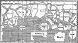
The classical albedo features of Mars are the light and dark features that can be seen on the planet Mars through an Earth-based telescope. Before the age of space probes, several astronomers created maps of Mars on which they gave names to the features they could see. The most popular system of nomenclature was devised by Giovanni Schiaparelli, who used names from classical antiquity. Today, the improved understanding of Mars enabled by space probes has rendered many of the classical names obsolete for the purposes of cartography; however, some of the old names are still used to describe geographical features on the planet.

<span class="mw-page-title-main">Geology of Mars</span> Scientific study of the surface, crust, and interior of the planet Mars

The geology of Mars is the scientific study of the surface, crust, and interior of the planet Mars. It emphasizes the composition, structure, history, and physical processes that shape the planet. It is analogous to the field of terrestrial geology. In planetary science, the term geology is used in its broadest sense to mean the study of the solid parts of planets and moons. The term incorporates aspects of geophysics, geochemistry, mineralogy, geodesy, and cartography. A neologism, areology, from the Greek word Arēs (Mars), sometimes appears as a synonym for Mars's geology in the popular media and works of science fiction. The term areology is also used by the Areological Society.

<span class="mw-page-title-main">Mars</span> Fourth planet from the Sun

Mars is the fourth planet from the Sun. The surface of Mars is orange-red because it is covered in iron(III) oxide dust, giving it the nickname "the Red Planet". Mars hosts many enormous extinct volcanos and one of the largest canyons in the Solar System. For comparison, Mars's diameter is 6,779 km (4,212 mi). It is classified as a terrestrial planet and is the second smallest of the Solar System's planets.

<span class="mw-page-title-main">Martian dichotomy</span> Geomorphological feature of Mars

The most conspicuous feature of Mars is a sharp contrast, known as the Martian dichotomy, between the Southern and the Northern hemispheres. The two hemispheres' geography differ in elevation by 1 to 3 km. The average thickness of the Martian crust is 45 km, with 32 km in the northern lowlands region, and 58 km in the southern highlands.

<span class="mw-page-title-main">Diacria quadrangle</span> Map of Mars

The Diacria quadrangle is one of a series of 30 quadrangle maps of Mars used by the United States Geological Survey (USGS) Astrogeology Research Program. The quadrangle is located in the northwestern portion of Mars’ western hemisphere and covers 180° to 240° east longitude and 30° to 65° north latitude. The quadrangle uses a Lambert conformal conic projection at a nominal scale of 1:5,000,000 (1:5M). The Diacria quadrangle is also referred to as MC-2. The Diacria quadrangle covers parts of Arcadia Planitia and Amazonis Planitia.

<span class="mw-page-title-main">Arcadia quadrangle</span> Map of Mars

The Arcadia quadrangle is one of a series of 30 quadrangle maps of Mars used by the United States Geological Survey (USGS) Astrogeology Research Program. The quadrangle is located in the north-central portion of Mars’ western hemisphere and covers 240° to 300° east longitude and 30° to 65° north latitude. The quadrangle uses a Lambert conformal conic projection at a nominal scale of 1:5,000,000 (1:5M). The Arcadia quadrangle is also referred to as MC-3.

<span class="mw-page-title-main">Tharsis quadrangle</span> Map of Mars

The Tharsis quadrangle is one of a series of 30 quadrangle maps of Mars used by the United States Geological Survey (USGS) Astrogeology Research Program. The Tharsis quadrangle is also referred to as MC-9 . The name Tharsis refers to a land mentioned in the Bible. It may be at the location of the old town of Tartessus at the mouth of Guadalquivir.

<span class="mw-page-title-main">Sinus Sabaeus quadrangle</span> Map of Mars

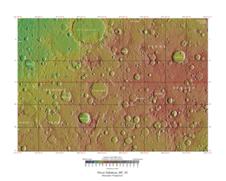
The Sinus Sabaeus quadrangle is one of a series of 30 quadrangle maps of Mars used by the United States Geological Survey (USGS) Astrogeology Research Program. It is also referred to as MC-20 . The Sinus Sabaeus quadrangle covers the area from 315° to 360° west longitude and 0° to 30° degrees south latitude on Mars. It contains Schiaparelli, a large, easily visible crater that sits close to the equator. The Sinus Sabaeus quadrangle contains parts of Noachis Terra and Terra Sabaea.

Fretted terrain is a type of surface feature common to certain areas of Mars and was discovered in Mariner 9 images. It lies between two different types of terrain. The surface of Mars can be divided into two parts: low, young, uncratered plains that cover most of the northern hemisphere, and high-standing, old, heavily cratered areas that cover the southern and a small part of the northern hemisphere. Between these two zones is a region called the Martian dichotomy and parts of it contain fretted terrain. This terrain contains a complicated mix of cliffs, mesas, buttes, and straight-walled and sinuous canyons. It contains smooth, flat lowlands along with steep cliffs. The scarps or cliffs are usually 1 to 2 km high. Channels in the area have wide, flat floors and steep walls. Fretted terrain shows up in northern Arabia, between latitudes 30°N and 50°N and longitudes 270°W and 360°W, and in Aeolis Mensae, between 10 N and 10 S latitude and 240 W and 210 W longitude. Two good examples of fretted terrain are Deuteronilus Mensae and Protonilus Mensae.

<span class="mw-page-title-main">Nilosyrtis Mensae</span> Fretted terrain in the Casius quadrangle on Mars

Nilosyrtis Mensae is an area of Mars in the Casius quadrangle. It is centered on the coordinates of 36.87° N and 67.9° E. Its western and eastern longitudes are 51.1° E and 74.4° E. North and south latitudes are 36.87° N and 29.61° N. Nilosyrtis Mensae is just to the east of Protonilus Mensae and both lie along the Martian dichotomy boundary. Its name was adapted by the IAU in 1973. It was named after a classical albedo feature, and it is 705 km (438 mi) across.

<span class="mw-page-title-main">Denning (Martian crater)</span> Crater on Mars

Denning Crater is a large Noachian-age impact crater in the southwestern Terra Sabaea region of the southern Martian highlands, within the Sinus Sabaeus quadrangle. It is located to the northwest of the Hellas impact basin within the furthest outskirts of the Hellas debris apron. The crater is 165 km in diameter and likely formed during the Late Heavy Bombardment, a period of intense bolide impacts affecting the entirety of the Solar System; during the Hesperian period, aeolian processes caused significant degradation of the crater's rim features and infilled the crater's floor. Similar to other large craters in this region of Mars, wind-eroded features are sporadically found on the basin floor. The presence of wrinkle ridges of varying orientations within and around the Denning basin has been correlated to regional tectonic events, including the formation of the Hellas basin itself. The crater was named for British astronomer William Frederick Denning.

<span class="mw-page-title-main">Hesperia Planum</span> Broad lava plain in the southern highlands of the planet Mars

Hesperia Planum is a broad lava plain in the southern highlands of the planet Mars. The plain is notable for its moderate number of impact craters and abundant wrinkle ridges. It is also the location of the ancient volcano Tyrrhena Mons. The Hesperian time period on Mars is named after Hesperia Planum.

<span class="mw-page-title-main">Brain terrain</span> Feature of the Martian surface

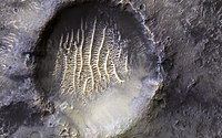
Brain terrain, also called knobs-brain coral and brain coral terrain, is a feature of the Martian surface, consisting of complex ridges found on lobate debris aprons, lineated valley fill and concentric crater fill. It is so named because it suggests the ridges on the surface of the human brain. Wide ridges are called closed-cell brain terrain, and the less common narrow ridges are called open-cell brain terrain. It is thought that the wide closed-cell terrain contains a core of ice, and when the ice disappears the center of the wide ridge collapses to produce the narrow ridges of the open-cell brain terrain. Shadow measurements from HiRISE indicate the ridges are 4-5 meters high. Brain terrain has been observed to form from what has been called an "Upper Plains Unit." The process begins with the formation of stress cracks. The upper plains unit fell from the sky as snow and as ice coated dust.

<span class="mw-page-title-main">Sinton (crater)</span> Crater on Mars

Sinton is a crater in the Ismenius Lacus quadrangle on Mars. Sinton crater lies in the northern hemisphere, south of the very large crater Lyot and west of Ismeniae Fossae. It was named after Harvard astronomer William M. Sinton. The name was approved in 2007.

The following outline is provided as an overview of and topical guide to Mars:

References

  1. "Areography". Merriam-Webster.com. Retrieved 27 July 2022.
  2. Lowell, Percival (April 1902). "Areography". Proceedings of the American Philosophical Society. 41 (170): 225-234. Retrieved 27 July 2022.
  3. Sheehan, William (19 September 2014). "Geography of Mars, or Areography". Astrophysics and Space Science Library. 409. doi:10.1007/978-3-319-09641-4_7.
  4. Chang, Kenneth (15 April 2023). "New Mars Map Lets You 'See the Whole Planet at Once' - Scientists assembled 3,000 images from an Emirati orbiter to create the prettiest atlas yet of the red planet". The New York Times . Retrieved 15 April 2023.
  5. Staff (16 April 2023). "Welcome to Mars! Caltech's Jaw-Dropping, 5.7 Terapixel Virtual Expedition Across the Red Planet". SciTech . Retrieved 6 April 2023.
  6. Morton, Oliver (2002). Mapping Mars: Science, Imagination, and the Birth of a World. New York: Picador USA. p. 98. ISBN   0-312-24551-3.
  7. "Online Atlas of Mars". Ralphaeschliman.com. Retrieved December 16, 2012.
  8. "PIA03467: The MGS MOC Wide Angle Map of Mars". Photojournal. NASA /Jet Propulsion Laboratory. February 16, 2002. Retrieved December 16, 2012.
  9. "Online Atlas of Mars". Ralphaeschliman.com. Retrieved December 16, 2012.
  10. "PIA03467: The MGS MOC Wide Angle Map of Mars". Photojournal. NASA /Jet Propulsion Laboratory. February 16, 2002. Retrieved December 16, 2012.
  11. Ardalan, A. A.; Karimi, R.; Grafarend, E. W. (2009). "A New Reference Equipotential Surface, and Reference Ellipsoid for the Planet Mars". Earth, Moon, and Planets. 106 (1): 1–13. doi:10.1007/s11038-009-9342-7. ISSN   0167-9295. S2CID   119952798.
  12. 1 2 Carr, M.H., 2006, The Surface of Mars, Cambridge, 307 p.
  13. Smith, D.; Zuber, M.; Frey, H.; Garvin, J.; Head, J.; et al. (25 October 2001). "Mars Orbiter Laser Altimeter: Experiment summary after the first year of global mapping of Mars" (PDF). Journal of Geophysical Research: Planets. 106 (E10): 23689–23722. Bibcode:2001JGR...10623689S. doi:10.1029/2000JE001364.
  14. 1 2 de Vaucouleurs, Gerard; Davies, Merton E.; Sturms, Francis M. Jr. (1973). "Mariner 9 areographic coordinate system". Journal of Geophysical Research. 78 (20): 4395–4404. Bibcode:1973JGR....78.4395D. doi:10.1029/JB078i020p04395.
  15. de Vaucouleurs, Gerard (1964). "The physical ephemeris of Mars". Icarus. 3 (3): 236–247. Bibcode:1964Icar....3..236D. doi:10.1016/0019-1035(64)90019-3.
  16. Malin Space Science Systems (31 January 2001). The Martian Prime Meridian – Longitude "Zero". NASA Jet Propulsion Laboratory (Report). National Aeronautics and Space Administration. MGS MOC Release No. MOC2-273. Retrieved 31 March 2018.
  17. Archinal, B.A.; Acton, C.H.; A'Hearn, M.F.; Conrad, A.; et al. (2018). "Report of the IAU Working Group on Cartographic Coordinates and Rotational Elements: 2015". Celestial Mechanics and Dynamical Astronomy. 130 (22): 22. Bibcode:2018CeMDA.130...22A. doi:10.1007/s10569-017-9805-5. S2CID   189844155.
  18. Greeley, R. and J. Guest. 1987. Geological map of the eastern equatorial region of Mars, scale 1:15,000,000. U. S. Geol. Ser. Misc. Invest. Map I-802-B, Reston, Virginia
  19. Plaut, J. et al. 2008. Radar Evidence for Ice in lobate debris aprons in the Mid-Northern Latitudes of Mars. Lunar and Planetary Science XXXIX. 2290.pdf
  20. 1 2 Watters, T. et al. 2007. Hemispheres Apart: The Crustal Dichotomy on Mars. Annual Review Earth Planet Science: 35. 621–652
  21. Irwin III, R. et al. 2004. Sedimentary resurfacing and fretted terrain development along the crustal dichotomy boundary, Aeolis Mensae, Mars.: 109. E09011
  22. Tanaka, K. et al. 2003. Resurfacing history of the northern plains of Mars based on geologic mapping of Mars Global surveyor data. Journal of Geophysical Research: 108. 8043
  23. Scott, D. and M. Carr. 1978. Geological map of Mars. U.S. Geol. Surv. Misc. Invest. Map I-803, Reston, Virginia
  24. Jeffrey C. Andrews-Hanna, Maria T. Zuber & W. Bruce Banerdt The Borealis basin and the origin of the martian crustal dichotomy Nature 453, 1212–1215 (26 June 2008)
  25. Ley, Willy and von Braun, Wernher The Exploration of Mars New York:1956 The Viking Press Pages 70–71 Schiaparelli's original map of Mars

Further reading