Martian chaos terrain

Last updated

Chaos terrain on Mars is distinctive; nothing on Earth compares to it. Chaos terrain generally consists of irregular groups of large blocks, some tens of kilometers across and a hundred or more meters high. The tilted and flat topped blocks form depressions hundreds of metres deep. [1] A chaotic region can be recognized by a rat's nest of mesas, buttes, and hills, chopped through with valleys which in places look almost patterned. [2] [3] [4] Some parts of this chaotic area have not collapsed completely—they are still formed into large mesas, so they may still contain water ice. [5] Chaos regions formed long ago. By counting craters (more craters in any given area means an older surface) and by studying the valleys' relations with other geological features, scientists have concluded the channels formed 2.0 to 3.8 billion years ago. [6]

Contents

Locations

The greatest concentrations of chaotic terrain are in the same locations as giant, ancient river valleys. Because so many large channels seem to originate from chaotic terrain, it is widely believed that chaos terrain is caused by water coming out the ground in the form of massive floods. [7] [8] Most of the chaotic terrain exists in the highlands of Mars, south of Chryse Planitia, in the Oxia Palus quadrangle, and along the Martian dichotomy. But some chaos regions can be found in Margaritifer Sinus quadrangle, Phaethontis quadrangle, and Lunae Palus quadrangle.

Theories for formation

Many different theories have been advanced for how floods of water came to be released with the formation of chaotic terrain. Evidence for the involvement of water has been found—minerals associated with water, such as grey, crystalline hematite and phyllosilicates, are present in chaos regions. [9] Many explanations for the creation of chaos involve the sudden melting of giant reservoirs of ground ice. Some researchers have suggested that a frozen layer, called a cryosphere, developed over a long time period and then something triggered it to rupture and melt suddenly. The rupturing event may have been impacts, [10] magma movements, [11] [12] seismic activity, [13] volcanic tectonic strains, [14] increased pore pressure, or the dissociation of clathrates. [15] [16] [17] [18] A clathrate composed of carbon dioxide and methane could have explosively dissociated, thereby liquefying water-saturated sediments. A variation of this idea of a cryosphere is that an aquifer was created along with the cryosphere. As more and more ice was added resulting in a thicker cryosphere, the water in the aquifer became pressurized. [19] When something like an impact or movement of magma broke or melted the cryosphere, floods of water under great pressure were released. However, further calculations showed that the great channels could not have been produced with just a single discharge. [20] Later proposals advanced the notion that the geological shapes present in chaos regions could have been made by a series of over 100 flooding events. [21]

Melting of buried ice

More recently, researchers have suggested ways for the formation of chaos without the need for a special triggering event. Tanja Zegers and others calculated that the simple burial of ice-rich sediments could result in the release of huge amounts of water leading to the formation of the large river basins that are associated with most chaos terrains. The group studied Aram Chaos, a large region of chaos that probably began as a large impact crater. In their model, ice-rich material accumulated in the crater and then became covered with sediment, which prevented the ice from disappearing into the thin atmosphere. Eventually, the heat from the deep subsurface together with the insulating qualities of the covering layer produced a thick water layer. Since dense materials tend to sink into water, the overlying rock broke under the strain. The dense, rocky cap fractured into various sized, tilted blocks. The melt water went to the top and made a channel which eroded more and more as water rushed outward. Along with water from other chaotic regions, there would have been enough erosive force to carve the large river valleys we now observe. [22] There is ample evidence for buried deposits of ice in the form of glaciers, preserved under a thin covering of rock and dirt. [23]

It also seems that Mars has had many ice ages in which ice was deposited, then later buried. These ice ages are caused by the frequent large changes in the tilt of the planet. [24] The tilt of the spin axis of Mars is highly variable due to the lack of a large moon. [25] [26] [27] Observations of many craters have shown that many craters are mostly full of sediments—ice could be one of the sediments. Many craters appear to be very shallow, but observations of younger craters have demonstrated that impact craters start out as sort of bowl shaped; hence a crater that today looks shallow has probably been filled with sediments. [28] [29] Research, published by Rodriguez and others in 2005, suggested that the subsurface of Mars contains an accumulation of old craters that may be filled with water or ice. [30]

Sublimation of an ice-rich layer

Some regions of chaos may have been produced by another means. Galaxias Chaos is different from many other chaotic regions. It does not have associated outflow channels, and it does not display a great elevation difference between it and the surrounding land area, as most of the other chaos regions. Research by Pedersen and Head, published in 2010, suggests that Galaxias Chaos is the site of a volcanic flow that buried an ice-rich layer, called the Vastitas Borealis Formation (VBF). [31] It is generally believed that the VBF is a residue from water-rich materials deposited by large floods. [32] [33] The VBF may have been of varied thickness and may have contained varied amounts of ice. In the thin atmosphere of Mars, this layer would have slowly disappeared by sublimation (changing from a solid directly to a gas). Since some areas would have sublimated more than others, the upper lava cap would not be supported evenly and would crack. Cracks/troughs may have begun from sublimation and shrinkage along the edges of the lava cap. Stress from the undermining of the cap edge would have made cracks in the cap. Places with cracks would undergo more sublimation, then the cracks would widen and form the blocky terrain characteristic of regions of chaos. The sublimation process may have been aided by heat (geothermal flux) from magma movements. There are volcanoes, namely Elysium Montes and Hecates Tholus, nearby which most likely are surrounded by dikes, which would have heated the ground. Also, a warmer period in the past would have increased the amount of water sublimating from the ground. [10]

Importance

Chaos terrain seems to be strong evidence for large amounts of water flowing on Mars in the past. Some of the terrain is not totally broken up, so perhaps more water exists frozen inside some of the blocks.

Chaos regions in Margaritifer Sinus quadrangle

Chaos regions in Oxia Palus quadrangle

Chaos regions in Phaethontis quadrangle

Chaos regions in Lunae Palus quadrangle

On April 1, 2010, NASA released the first images under the HiWish program in which just plain folk suggested places for HiRISE to photograph. One of the eight locations was Aureum Chaos. [34] The first image below gives a wide view of the area. The next two images are from the HiRISE image. [35]

See also

Related Research Articles

Vallis or valles is the Latin word for valley. It is used in planetary geology to name landform features on other planets.

<span class="mw-page-title-main">Ares Vallis</span> Vallis on Mars

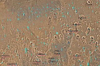
Ares Vallis is an outflow channel on Mars, named after the Greek name for Mars: Ares, the god of war; it appears to have been carved by fluids, perhaps water. The valley 'flows' northwest out of the hilly Margaritifer Terra, where the Iani Chaos depression 180 km (110 mi) long and 200 km (120 mi) wide) is connected to the beginning of Ares Vallis by a 100 km (62 mi) wide transition zone centered on 342.5° East and 3° North. It then continues through the ancient Xanthe Terra highlands, and ends in a delta-like region of Chryse Planitia. Ares Vallis was the landing site of NASA's Mars Pathfinder spacecraft, which studied a region of the valley near the border with Chryse in 1997.

<span class="mw-page-title-main">Margaritifer Terra</span> Terra on Mars

Margaritifer Terra is an ancient, heavily cratered region of Mars. It is centered just south of the Martian equator at 4.9°S 25°W and covers 2600 km at its widest extent. The area reveals "chaos terrain", outflow channels, and alluvial plains that are indicative of massive flooding. Wind erosion patterns are also in evidence. A region within the terra shows some of the highest valley network densities on the planet. Ares Vallis is another notable feature, where the flood and flow patterns are in evidence; it was the landing site of the Soviet Mars 6 lander and NASA's Mars Pathfinder. It is also one of several proposed landing sites for the Mars 2020 Rover.

<span class="mw-page-title-main">Chaos terrain</span> Distinctive area of broken or jumbled terrain

In astrogeology, chaos terrain, or chaotic terrain, is a planetary surface area where features such as ridges, cracks, and plains appear jumbled and enmeshed with one another. Chaos terrain is a notable feature of the planets Mars and Mercury, Jupiter's moon Europa, and the dwarf planet Pluto. In scientific nomenclature, "chaos" is used as a component of proper nouns.

<span class="mw-page-title-main">Aram Chaos</span> Crater on Mars

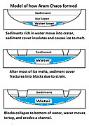
Aram Chaos, centered at 2.6°N, 21.5°W, is a heavily eroded impact crater on Mars. It lies at the eastern end of the large canyon Valles Marineris and close to Ares Vallis. Various geological processes have reduced it to a circular area of chaotic terrain. Aram Chaos takes its name from Aram, one of the classical albedo features observed by Giovanni Schiaparelli, who named it after the Biblical land of Aram. Spectroscopic observation from orbit indicates the presence of the mineral hematite, likely a signature of a once aqueous environment.

<span class="mw-page-title-main">Cebrenia quadrangle</span> One of 30 quadrangle maps of Mars used by the US Geological Survey

The Cebrenia quadrangle is one of a series of 30 quadrangle maps of Mars used by the United States Geological Survey (USGS) Astrogeology Research Program. The quadrangle is located in the northeastern portion of Mars’ eastern hemisphere and covers 120° to 180° east longitude and 30° to 65° north latitude. The quadrangle uses a Lambert conformal conic projection at a nominal scale of 1:5,000,000 (1:5M). The Cebrenia quadrangle is also referred to as MC-7. It includes part of Utopia Planitia and Arcadia Planitia. The southern and northern borders of the Cebrenia quadrangle are approximately 3,065 km (1,905 mi) and 1,500 km (930 mi) wide, respectively. The north to south distance is about 2,050 km (1,270 mi). The quadrangle covers an approximate area of 4.9 million square km, or a little over 3% of Mars’ surface area.

<span class="mw-page-title-main">Oxia Palus quadrangle</span> Map of Mars

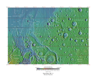
The Oxia Palus quadrangle is one of a series of 30 quadrangle maps of Mars used by the United States Geological Survey (USGS) Astrogeology Research Program. The Oxia Palus quadrangle is also referred to as MC-11.

<span class="mw-page-title-main">Coprates quadrangle</span> Map of Mars

The Coprates quadrangle is one of a series of 30 quadrangle maps of Mars used by the United States Geological Survey (USGS) Astrogeology Research Program. The Coprates quadrangle is also referred to as MC-18. The Coprates quadrangle contains parts of many of the old classical regions of Mars: Sinai Planum, Solis Planum, Thaumasia Planum, Lunae Planum, Noachis Terra, and Xanthe Terra.

<span class="mw-page-title-main">Margaritifer Sinus quadrangle</span> One of a series of 30 quadrangle maps of Mars

The Margaritifer Sinus quadrangle is one of a series of 30 quadrangle maps of Mars used by the United States Geological Survey (USGS) Astrogeology Research Program. The Margaritifer Sinus quadrangle is also referred to as MC-19. The Margaritifer Sinus quadrangle covers the area from 0° to 45° west longitude and 0° to 30° south latitude on Mars. Margaritifer Sinus quadrangle contains Margaritifer Terra and parts of Xanthe Terra, Noachis Terra, Arabia Terra, and Meridiani Planum.

<span class="mw-page-title-main">Hellas quadrangle</span> Map of Mars

The Hellas quadrangle is one of a series of 30 quadrangle maps of Mars used by the United States Geological Survey (USGS) Astrogeology Research Program. The Hellas quadrangle is also referred to as MC-28 . The Hellas quadrangle covers the area from 240° to 300° west longitude and 30° to 65° south latitude on the planet Mars. Within the Hellas quadrangle lies the classic features Hellas Planitia and Promethei Terra. Many interesting and mysterious features have been discovered in the Hellas quadrangle, including the giant river valleys Dao Vallis, Niger Vallis, Harmakhis, and Reull Vallis—all of which may have contributed water to a lake in the Hellas basin in the distant past. Many places in the Hellas quadrangle show signs of ice in the ground, especially places with glacier-like flow features.

<span class="mw-page-title-main">Phaethontis quadrangle</span> Map of Mars

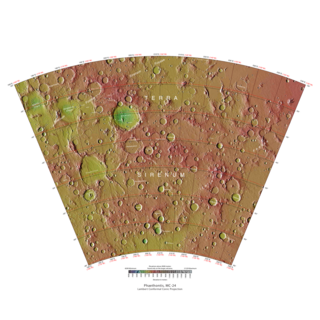
The Phaethontis quadrangle is one of a series of 30 quadrangle maps of Mars used by the United States Geological Survey (USGS) Astrogeology Research Program. The Phaethontis quadrangle is also referred to as MC-24.

<span class="mw-page-title-main">Hydaspis Chaos</span> Chaos on Mars

Hydaspis Chaos is a region in the Oxia Palus quadrangle of Mars, located at 3.2° north latitude and 27.1° west longitude. The region is about 355 km across. It was named after a classical albedo feature.

<span class="mw-page-title-main">Aureum Chaos</span> Chaos on Mars

Aureum Chaos is a rough, collapsed region in the Margaritifer Sinus quadrangle (MC-19) portion of the planet Mars at approximately 4.4° south latitude and 27° west longitude, it is also in the west of Margaritifer Terra. It is 368 km across and was named after a classical albedo feature name.

<span class="mw-page-title-main">Lineated valley fill</span> Martian geologic feature

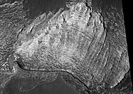
Lineated valley fill (LVF), also called lineated floor deposit, is a feature of the floors of some channels on Mars, exhibiting ridges and grooves that seem to flow around obstacles. Shadow measurements show that at least some of the ridges are several metres high. LVF is believed to be ice-rich. Hundreds of metres of ice probably lie protected in LVF under a thin layer of debris. The debris consists of wind-borne dust, material from alcove walls, and lag material remaining after ice sublimated from a rock-ice mixture. Some glaciers on Earth show similar ridges. High-resolution pictures taken with HiRISE reveal that some of the surfaces of lineated valley fill are covered with strange patterns called closed-cell and open-cell brain terrain. The terrain resembles a human brain. It is believed to be caused by cracks in the surface accumulating dust and other debris, together with ice sublimating from some of the surfaces. The cracks are the result stress from gravity and seasonal heating and cooling. This same type of surface is present on Lobate debris aprons and Concentric crater fill so all three are believed to be related.

HiWish is a program created by NASA so that anyone can suggest a place for the HiRISE camera on the Mars Reconnaissance Orbiter to photograph. It was started in January 2010. In the first few months of the program 3000 people signed up to use HiRISE. The first images were released in April 2010. Over 12,000 suggestions were made by the public; suggestions were made for targets in each of the 30 quadrangles of Mars. Selected images released were used for three talks at the 16th Annual International Mars Society Convention. Below are some of the over 4,224 images that have been released from the HiWish program as of March 2016.

To date, interplanetary spacecraft have provided abundant evidence of water on Mars, dating back to the Mariner 9 mission, which arrived at Mars in 1971. This article provides a mission by mission breakdown of the discoveries they have made. For a more comprehensive description of evidence for water on Mars today, and the history of water on that planet, see Water on Mars.

The Mars orbiter 2001 Mars Odyssey found much evidence for water on Mars in the form of pictures, and with a spectrometer it proved that much of the ground is loaded with ice.

The common surface features of Mars include dark slope streaks, dust devil tracks, sand dunes, Medusae Fossae Formation, fretted terrain, layers, gullies, glaciers, scalloped topography, chaos terrain, possible ancient rivers, pedestal craters, brain terrain, and ring mold craters.

<span class="mw-page-title-main">Arsinoes Chaos</span>

Arsinoes Chaos is a chaos terrain in the Margaritifer Sinus quadrangle on Mars. It is 200 km in diameter. Its location is 7.66 °S and 27.9 °W. Arsinoes Chaos was named after Arsinoe, a queen of ancient Egypt, daughter of Ptolemy and Berenice.

<span class="mw-page-title-main">Equatorial layered deposits</span> Surface geological deposits on Mars

Equatorial layered deposits (ELD’s) have been called interior layered deposits (ILDs) in Valles Marineris. They are often found with the most abundant outcrops of hydrated sulfates on Mars, and thus are likely to preserve a record of liquid water in Martian history since hydrated sulfates are formed in the presence of water. Layering is visible on meter scale, and when the deposits are partly eroded, intricate patterns become visible. The layers in the mound in Gale Crater have been extensively studied from orbit by instruments on the Mars Reconnaissance Orbiter. The Curiosity Rover landed in the crater, and it has brought some ground truth to the observations from satellites. Many of the layers in ELD’s such as in Gale Crater are composed of fine-grained, easily erodible material as are many other layered deposits. On the basis of albedo, erosion patterns, physical characteristics, and composition, researchers have classified different groups of layers in Gale Crater that seem to be similar to layers in other (ELD’s). The groups include: a small yardang unit, a coarse yardang unit, and a terraced unit. Generally, equatorial layered deposits are found ~ ±30° of the equator. Equatorial Layered Deposits appear in various geological settings such as cratered terrains, chaotic terrains, the Valles Marineris chasmata, and large impact craters.
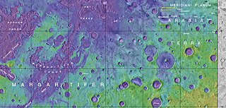
References

  1. Meresse, S.; et al. (2008). "Formation and evolution of the chaotic terrains by subsidence and magmatism: Hydraotes Chaos, Mars". Icarus. 194 (2): 487–500. Bibcode:2008Icar..194..487M. doi:10.1016/j.icarus.2007.10.023.
  2. Sharp, R. (1973). "Mars: Fretted and chaotic terrains" (PDF). J. Geophys. Res. 78 (20): 4073–4083. Bibcode:1973JGR....78.4073S. doi:10.1029/JB078i020p04073.
  3. Carr, M. 2006. The Surface of Mars. Cambridge University Press. ISBN   978-0-521-87201-0
  4. Forget, F., et al. 2006. Planet Mars Story of Another World. Praxis Publishing, Chichester, UK. ISBN   978-0-387-48925-4
  5. "Unraveling the Chaos of Aram | Mars Odyssey Mission THEMIS".
  6. "When Chaos Erupted in Hydraotes | Mars Odyssey Mission THEMIS".
  7. Carr, M. 1978. Formation of martian flood features by release of water from confined aquifers. NASA Technical Memorandum 79729. 260-262.
  8. Carr, M. (1979). "Formation of martian flood features by release of water from confined aquifers". J. Geophys. Res. 84: 2995–3007. Bibcode:1979JGR....84.2995C. doi:10.1029/JB084iB06p02995.
  9. Glotch, Timothy D. (2005). "Geologic and mineralogic mapping of Aram Chaos: Evidence for a water-rich history". Journal of Geophysical Research. 110. Bibcode:2005JGRE..11009006G. doi: 10.1029/2004JE002389 .
  10. 1 2 3 Pedersen, G.; Head, J. (2011). "Chaos formation by sublimation of volatile-rich substrate: evidence from Galaxias Chaos, Mars". Icarus. 211 (1): 316–329. Bibcode:2011Icar..211..316P. doi:10.1016/j.icarus.2010.09.005.
  11. Chapman, M.; Tanaka, K. (2002). "Related magma-ice interactions: Possible origins of Chasma chaos and surface materials in Xanthe, Margaritifer, and Merdiani Terrae, Mars". Icarus. 155 (2): 324–339. Bibcode:2002Icar..155..324C. doi:10.1006/icar.2001.6735.
  12. Head, J. and L. Wilson. 2002. Mars: A review and synthesis of general environments and geological settings of Magma-H2O interactions. In: SmeilieJ. And M. Chapman. (EDS.). Volcanic-ice Interactions on Earth and Mars. Geological Society. London
  13. Tanaka, K. (1999). "Debris-flow origin for Simud/Tiu deposits on Mars". J. Geophys. Res. 104 (E4): 8637–8652. Bibcode:1999JGR...104.8637T. doi:10.1029/98JE02552.
  14. Cabrol, Nathalie A.; et al. (1997). "A model of outflow generation by hydrothermal underpressure drainage in volcano-tectonic environment. Shalbatana Vallis (Mars)". Icarus. 125 (2): 455–464. Bibcode:1997Icar..125..455C. doi:10.1006/icar.1996.5625.
  15. Milton, DJ (1974). "Carbon dioxide hydrate and floods on Mars". Science. 183 (4125): 654–656. Bibcode:1974Sci...183..654M. doi:10.1126/science.183.4125.654. PMID   17778840. S2CID   26421605.
  16. Hoffmann, H. (2000). "White Mars: A new model for Mars' surface and atmosphere based CO2". Icarus. 146 (2): 326–342. Bibcode:2000Icar..146..326H. doi:10.1006/icar.2000.6398.
  17. Komatsu, G. et al. 2000. A chaotic terrain formation hypothesis: Explosive outgas and outflow by dissociation of clathrate on Mars. Lunar Planet. Sci. XXXI. 1434.
  18. Rodriguez, J. A. P.; Kargel, Jeffrey; Crown, David A.; Bleamaster, Leslie F.; Tanaka, Kenneth L.; Baker, Victor; Miyamoto, Hideaki; Dohm, James M.; Sasaki, Sho; Komatsu, Goro (2006). "Headward growth of chasmata by volatile outbursts, collapse, and drainage: Evidence from Ganges chaos, Mars". Geophysical Research Letters. 33 (18): 18203. Bibcode:2006GeoRL..3318203R. doi:10.1029/2006GL026275.
  19. Clifford, S. (1993). "A model for the hydrologic and climatic behaviour of water on mars". J. Geophys. Res. 98 (E6): 10973–11016. Bibcode:1993JGR....9810973C. doi:10.1029/93JE00225.
  20. Baker, V. (2001). "Water and the martian landscape". Nature. 412 (6843): 228–236. Bibcode:2001Natur.412..228B. doi:10.1038/35084172. PMID   11449284.
  21. Harrison, Keith P.; Grimm, Robert E. (2008). "Multiple flooding events in Martian outflow channels". Journal of Geophysical Research. 113 (E2): E02002. Bibcode:2008JGRE..113.2002H. doi: 10.1029/2007je002951 .
  22. 1 2 Zegers, T.; et al. (2010). "Melt and collapse of buried water ice: An alternative hypothesis for the formation of chaotic terrains on Mars". Earth and Planetary Science Letters. 297 (3–4): 496–504. Bibcode:2010E&PSL.297..496Z. doi:10.1016/j.epsl.2010.06.049.
  23. Head, J.; Neukum, G.; Jaumann, R.; Hiesinger, H.; Hauber, E.; Carr, M.; Masson, P.; Foing, B.; Hoffmann, H.; et al. (2005). "Tropical to mid-latitude snow and ice accumulation, flow and glaciation on Mars". Nature. 434 (7031): 346–350. Bibcode:2005Natur.434..346H. doi:10.1038/nature03359. PMID   15772652. S2CID   4363630.
  24. Head, J.; et al. (2006). "Extensive valley glacier deposits in the northern mid-latitudes of Mars: Evidence for the late Amazonian obliquity-driven climate change". Earth Planet. Sci. Lett. 241 (3–4): 663–671. Bibcode:2006E&PSL.241..663H. doi:10.1016/j.epsl.2005.11.016.
  25. Madeleine, J. et al. 2007. Mars: A proposed climatic scenario for northern mid-latitude glaciation. Lunar Planet. Sci. 38. Abstract 1778.
  26. Madeleine, J.; Forget, F.; Head, James W.; Levrard, B.; Montmessin, F.; Millour, E. (2009). "Amazonian northern mid-latitude glaciation on Mars: A proposed climate scenario" (PDF). Icarus. 203 (2): 300–405. Bibcode:2009Icar..203..390M. doi:10.1016/j.icarus.2009.04.037.
  27. Mischna, M.; Richardson, Mark I.; Wilson, R. John; McCleese, Daniel J. (2003). "On the orbital forcing of martian water and CO2 cycles: A general circulation model study with simplified volatile schemes". J. Geophys. Res. 108 (E6): 5062. Bibcode:2003JGRE..108.5062M. doi:10.1029/2003JE002051.
  28. Parker, M.; et al. (2010). "3D structure of the Gusev Crater region". Earth and Planetary Science Letters. 294 (3–4): 411–423. Bibcode:2010E&PSL.294..411P. doi:10.1016/j.epsl.2010.01.013.
  29. Kreslavsky, M.; Head, J. (2006). "Modification of impact craters in the northern plains of Mars: Implications for the Amazonian climate history". Meteorit. Planet. Sci. 41 (10): 1633–1646. Bibcode:2006M&PS...41.1633K. doi: 10.1111/j.1945-5100.2006.tb00441.x .
  30. Rodríguez, Jose Alexis Palmero (2005). "Control of impact crater fracture systems on subsurface hydrology, ground subsidence, and collapse, Mars". Journal of Geophysical Research. 110. Bibcode:2005JGRE..11006003R. doi: 10.1029/2004JE002365 .
  31. Pedersen, G., J. Head. 2010. Chaos formation by sublimation of volatile-rich substrate: Evidence from Galaxias Chaos, Mars. Icarus: 211, 316–329.
  32. Kreslavsky, Mikhail A.; Head, James W. (2002). "Fate of outflow channel effluents in the northern lowlands of Mars: The Vastitas Borealis Formation as a sublimation residue from frozen ponded bodies of water". Journal of Geophysical Research. 107 (E12): 4-1–4-25. Bibcode:2002JGRE..107.5121K. doi: 10.1029/2001JE001831 .
  33. Carr, Michael H.; Head, James W. (2003). "Oceans on Mars: An assessment of the observational evidence and possible fate" (PDF). Journal of Geophysical Research. 108 (E5): 5042. Bibcode:2003JGRE..108.5042C. doi:10.1029/2002JE001963.
  34. "HiRISE | Captioned Image Inspired by HiWish Suggestions". Uahirise.org. Retrieved 2022-03-21.
  35. "HiRISE | Mesas in Aureum Chaos (ESP_016869_1775)".