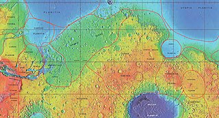
MOLA colorized relief map of Amazonis Planitia, the type area for the Amazonian System. Amazonis Planitia is characterized by low rates of meteorite and asteroid impacts. Colors indicate elevation, with red highest, yellow intermediate, and green/blue lowest.
The Amazonian is a geologic system and time period on the planet Mars characterized by low rates of meteorite and asteroidimpacts and by cold, hyperarid conditions broadly similar to those on Mars today.[1][2] The transition from the preceding Hesperian period is somewhat poorly defined. The Amazonian is thought to have begun around 3 billion years ago, although error bars on this date are extremely large (~500 million years).[3] The period is sometimes subdivided into the Early, Middle, and Late Amazonian. The Amazonian continues to the present day.
The Amazonian period has been dominated by impact crater formation and Aeolian processes with ongoing isolated volcanism occurring in the Tharsis region and Cerberus Fossae, including signs of activity as recently as a tens of thousands of years ago in the latter[4] and within the past few million years on Olympus Mons, implying they may still be active but dormant in the present.[5]
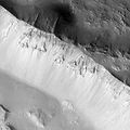
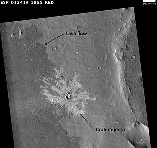
HiRISE image illustrating superpositioning, a principle that lets geologists determine the relative ages of surface units. The dark-toned lava flow overlies (is younger than) the light-toned, more heavily cratered terrain (older lava flow?) at right. The ejecta of the crater at center overlies both units, indicating that the crater is the youngest feature in the image.
Because it is the youngest of the Martian periods, the chronology of the Amazonian is comparatively well understood through traditional geological laws of superposition coupled to the relative dating technique of crater counting. The scarcity of craters characteristic of the Amazonian also means that unlike the older periods, fine scale (<100 m) surface features are preserved.[6] This enables detailed, process-orientated study of many Amazonian-age surface features of Mars as the necessary details of form of the surface are still visible.
Furthermore, the relative youth of this period means that over the past few 100 million years it remains possible to reconstruct the statistics of the orbital mechanics of the Sun, Mars, and Jupiter without the patterns being overwhelmed by chaotic effects, and from this to reconstruct the variation of solar insolation – the amount of heat from the sun – reaching Mars through time.[7] Climatic variations have been shown to occur in cycles not dissimilar in magnitude and duration to terrestrial Milankovich cycles.
Together, these features – good preservation, and an understanding of the imposed solar flux – mean that much research on the Amazonian of Mars has focussed on understanding its climate, and the surfaceprocesses that respond to the climate. This has included:
smaller than an age/stage; not used by the ICS timescale
System and Period are not interchangeable terms in formal stratigraphic nomenclature, although they are frequently confused in popular literature. A system is an idealized stratigraphic column based on the physical rock record of a type area (type section) correlated with rocks sections from many different locations planetwide.[30] A system is bound above and below by strata with distinctly different characteristics (on Earth, usually index fossils) that indicate dramatic (often abrupt) changes in the dominant fauna or environmental conditions. (See Cretaceous–Paleogene boundary as example.)
At any location, rock sections in a given system are apt to contain gaps (unconformities) analogous to missing pages from a book. In some places, rocks from the system are absent entirely due to nondeposition or later erosion. For example, rocks of the Cretaceous System are absent throughout much of the eastern central interior of the United States. However, the time interval of the Cretaceous (Cretaceous Period) still occurred there. Thus, a geologic period represents the time interval over which the strata of a system were deposited, including any unknown amounts of time present in gaps.[30] Periods are measured in years, determined by radioactive dating. On Mars, radiometric ages are not available except from Martian meteorites whose provenance and stratigraphic context are unknown. Instead, absolute ages on Mars are determined by impact crater density, which is heavily dependent upon models of crater formation over time.[31] Accordingly, the beginning and end dates for Martian periods are uncertain, especially for the Hesperian/Amazonian boundary, which may be in error by a factor of 2 or 3.[32][33]
Images
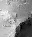
Pedestal crater in Amazonis with Dark Slope Streaks, as seen by HiRISE.
↑ Tanaka, K.L. (1986). The Stratigraphy of Mars. J. Geophys. Res., Seventeenth Lunar and Planetary Science Conference Part 1, 91(B13), E139–E158.
↑ Carr, M.H. (2006), The Surface of Mars. Cambridge Planetary Science Series, Cambridge University Press.
↑ Werner, S. C., and K. L. Tanaka (2011), Redefinition of the crater-density and absolute-age boundaries for the chronostratigraphic system of Mars, Icarus, 215(2), 603–607, doi:10.1016/j.icarus.2011.07.024.
↑ Irwin, R.P., Tanaka, K.L., and Robbins, S.J., 2013, Distribution of Early, Middle, and Late Noachian cratered surfaces in the Martian highlands: Implications for resurfacing events and processes: Journal of Geophysical Research, v. 118, p. 278–291, doi:10.1002/jgre.20053.
↑ Laskar, J., Correia, A.C.M., Gastineau, M., Joutel, F., Levrard, B., and Robutel, P., 2004, Long term evolution and chaotic diffusion of the insolation quantities of Mars: Icarus, v. 170, no. 2, p. 343–364, doi:10.1016/j.icarus.2004.04.005.
↑ Dickson, J.L., Head, J.W., III, and Marchant, D.R., 2010, Kilometer-thick ice accumulation and glaciation in the northern mid-latitudes of Mars: Evidence for crater-filling events in the Late Amazonian at the Phlegra Montes: Earth and Planetary Science Letters, v. 294, no. 3–4, p. 332–342, doi:10.1016/j.epsl.2009.08.031.
↑ Head, J.W., III, Mustard, J.F., Kreslavsky, M.A., Milliken, R.E., and Marchant, D.R., 2003, Recent ice ages on Mars: Nature, v. 426, p. 797–802.
↑ Levy, J.S., Head, J.W., III, and Marchant, D.R., 2009, Concentric crater fill in Utopia Planitia: History and interaction between glacial “brain terrain” and periglacial mantle processes: Icarus, v. 202, p. 462–476, doi:10.1016/j.icarus.2009.02.018.
↑ Fassett, C.I., Dickson, J.L., Head, J.W., III, Levy, J.S., and Marchant, D.R., 2010, Supraglacial and proglacial valleys on Amazonian Mars: Icarus, v. 208, no. 1, p. 86–100, doi:10.1016/j.icarus.2010.02.021.
↑ Salese, F., G. Di Achille, A. Neesemann, G. G. Ori, and E. Hauber (2016), Hydrological and sedimentary analyses of well-preserved paleofluvial-paleolacustrine systems at Moa Valles, Mars, J. Geophys. Res. Planets, 121, 194–232, doi:10.1002/2015JE004891.
↑ Leblanc, F., and R. E. Johnson. "Role of molecular species in pickup ion sputtering of the Martian atmosphere." Journal of Geophysical Research: Planets (1991–2012) 107.E2 (2002): 5–1.
↑ Burr, D.M., Grier, J.A., McEwen, A.S., and Keszthelyi, L.P., 2002, Repeated Aqueous Flooding from the Cerberus Fossae: Evidence for Very Recently Extant, Deep Groundwater on Mars: Icarus, v. 159, no. 1, p. 53–73, doi:10.1006/icar.2002.6921.
↑ Kolb, Eric J., and Kenneth L. Tanaka. "Geologic history of the polar regions of Mars based on Mars Global Surveyor data: II. Amazonian Period." Icarus 154.1 (2001): 22–39.
↑ Kieffer, Hugh H., Philip R. Christensen, and Timothy N. Titus. "CO2 jets formed by sublimation beneath translucent slab ice in Mars' seasonal south polar ice cap." Nature 442.7104 (2006): 793–796.
↑ Balme, Matt, et al. "Transverse aeolian ridges (TARs) on Mars." Geomorphology 101.4 (2008): 703–720.
↑ Basu, Shabari, Mark I. Richardson, and R. John Wilson. "Simulation of the Martian dust cycle with the GFDL Mars GCM." Journal of Geophysical Research: Planets (1991–2012) 109.E11 (2004).
↑ Read, Peter L., and Stephen R. Lewis. The Martian climate revisited: Atmosphere and environment of a desert planet. Springer Verlag, 2004.
↑ Jakosky, Bruce M., and Roger J. Phillips. "Mars' volatile and climate history." nature 412.6843 (2001): 237–244.
↑ Mangold, N., et al. "A Late Amazonian alteration layer related to local volcanism on Mars." Icarus 207.1 (2010): 265–276.
↑ Hartmann, William K., and Daniel C. Berman. "Elysium Planitia lava flows: Crater count chronology and geological implications." Journal of Geophysical Research: Planets (1991–2012) 105.E6 (2000): 15011–15025.
↑ Neukum, Gerhard, et al. "Recent and episodic volcanic and glacial activity on Mars revealed by the High Resolution Stereo Camera." Nature 432.7020 (2004): 971–979.
↑ Márquez, Álvaro, et al. "New evidence for a volcanically, tectonically, and climatically active Mars." Icarus 172.2 (2004): 573–581.
↑ Mueller, Karl, and Matthew Golombek. "Compressional structures on Mars." Annu. Rev. Earth Planet. Sci. 32 (2004): 435–464.
↑ Robbins, Stuart J., and Brian M. Hynek. "Distant secondary craters from Lyot crater, Mars, and implications for surface ages of planetary bodies." Geophysical Research Letters 38.5 (2011).
↑ Malin, Michael C., et al. "Present-day impact cratering rate and contemporary gully activity on Mars." science 314.5805 (2006): 1573–1577.
↑ Popova, Olga, Ivan Nemtchinov, and William K. Hartmann. "Bolides in the present and past Martian atmosphere and effects on cratering processes." Meteoritics & Planetary Science 38.6 (2003): 905–925.
1 2 Eicher, D.L.; McAlester, A.L. (1980).History of the Earth; Prentice-Hall: Englewood Cliffs, NJ, pp 143–146, ISBN0-13-390047-9.
↑ Masson, P.; Carr, M.H.; Costard, F.; Greeley, R.; Hauber, E.; Jaumann, R. (2001). Geomorphologic Evidence for Liquid Water. Space Science Reviews,96, p. 352.
↑ Nimmo, F.; Tanaka, K. (2005). Early Crustal Evolution of Mars. Annu. Rev. Earth Planet. Sci.,33, 133–161.
↑ Hartmann, W.K.; Neukum, G. (2001). Cratering Chronology and Evolution of Mars. In Chronology and Evolution of Mars, Kallenbach, R. et al. Eds., Space Science Reviews,96: 105–164.
Bibliography and recommended reading
Boyce, Joseph, M. (2008). The Smithsonian Book of Mars; Konecky & Konecky: Old Saybrook, CT, ISBN978-1-58834-074-0
Carr, Michael, H. (2006). The Surface of Mars; Cambridge University Press: Cambridge, UK, ISBN978-0-521-87201-0.
Hartmann, William, K. (2003). A Traveler’s Guide to Mars: The Mysterious Landscapes of the Red Planet; Workman: New York, ISBN0-7611-2606-6.
Morton, Oliver (2003). Mapping Mars: Science, Imagination, and the Birth of a World; Picador: New York, ISBN0-312-42261-X.
Utopia Planitia is a large plain within Utopia, the largest recognized impact basin on Mars and in the Solar System with an estimated diameter of 3,300 km (2,100 mi). It is the Martian region where the Viking 2 lander touched down and began exploring on September 3, 1976, and the Zhurong rover touched down on May 14, 2021, as a part of the Tianwen-1 mission. It is located at the antipode of Argyre Planitia, centered at 46.7°N 117.5°E. It is also in the Casius quadrangle, Amenthes quadrangle, and the Cebrenia quadrangle of Mars.
Hellas Planitia is a plain located within the huge, roughly circular impact basin Hellas located in the southern hemisphere of the planet Mars. Hellas is the third- or fourth-largest known impact crater in the Solar System. The basin floor is about 7,152 m (23,465 ft) deep, 3,000 m (9,800 ft) deeper than the Moon's South Pole-Aitken basin, and extends about 2,300 km (1,400 mi) east to west. It is centered at 42.4°S 70.5°E. Hellas Planitia spans the boundary between the Hellas quadrangle and the Noachis quadrangle.
Amazonis Planitia is one of the smoothest plains on Mars. It is located between the Tharsis and Elysium volcanic provinces, to the west of Olympus Mons, in the Amazonis and Memnonia quadrangles, centered at 24.8°N 196.0°E. The plain's topography exhibits extremely smooth features at several different lengths of scale. A large part of the Medusae Fossae Formation lies in Amazonis Planitia.
Elysium, located in the Elysium and Cebrenia quadrangles, is the second largest volcanic region on Mars, after Tharsis. The region includes the volcanoes Hecates Tholus, Elysium Mons and Albor Tholus. The province is centered roughly on Elysium Mons at 24.7°N 150°E. Elysium Planitia is a broad plain to the south of Elysium, centered at 3.0°N 154.7°E. Another large volcano, Apollinaris Mons, lies south of Elysium Planitia and is not part of the province. Besides having large volcanoes, Elysium has several areas with long trenches, called fossa or fossae (plural) on Mars. They include the Cerberus Fossae, Elysium Fossae, Galaxias Fossae, Hephaestus Fossae, Hyblaeus Fossae, Stygis Fossae and Zephyrus Fossae.
Tempe Terra is a heavily cratered highland region in the northern hemisphere of the planet Mars. Located at the northeastern edge of the Tharsis volcanic province, Tempe Terra is notable for its high degree of crustal fracturing and deformation. The region also contains many small shield volcanoes, lava flows, and other volcanic structures.
Terra Sabaea is a large area on Mars. Its coordinates are 2°N42°E and it covers 4,700 kilometres (2,900 mi) at its broadest extent. It was named in 1979 after a classic albedo feature on the planet. Terra Sabaea is fairly large and parts of it are found in five quadrangles: Arabia quadrangle, Syrtis Major quadrangle, Iapygia quadrangle, Ismenius Lacus quadrangle, and Sinus Sabaeus quadrangle.
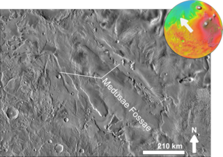
The Medusae Fossae Formation is a large geological formation of probable volcanic origin on the planet Mars. It is named for the Medusa of Greek mythology. "Fossae" is Latin for "trenches". The formation is a collection of soft, easily eroded deposits that extends discontinuously for more than 5,000 km along the equator of Mars. Its roughly-shaped regions extend from just south of Olympus Mons to Apollinaris Patera, with a smaller additional region closer to Gale Crater.
The Cebrenia quadrangle is one of a series of 30 quadrangle maps of Mars used by the United States Geological Survey (USGS) Astrogeology Research Program. The quadrangle is located in the northeastern portion of Mars' eastern hemisphere and covers 120° to 180° east longitude and 30° to 65° north latitude. The quadrangle uses a Lambert conformal conic projection at a nominal scale of 1:5,000,000 (1:5M). The Cebrenia quadrangle is also referred to as MC-7. It includes part of Utopia Planitia and Arcadia Planitia. The southern and northern borders of the Cebrenia quadrangle are approximately 3,065 km (1,905 mi) and 1,500 km (930 mi) wide, respectively. The north to south distance is about 2,050 km (1,270 mi). The quadrangle covers an approximate area of 4.9 million square km, or a little over 3% of Mars' surface area.
The Diacria quadrangle is one of a series of 30 quadrangle maps of Mars used by the United States Geological Survey (USGS) Astrogeology Research Program. The quadrangle is located in the northwestern portion of Mars' western hemisphere and covers 180° to 240° east longitude and 30° to 65° north latitude. The quadrangle uses a Lambert conformal conic projection at a nominal scale of 1:5,000,000 (1:5M). The Diacria quadrangle is also referred to as MC-2. The Diacria quadrangle covers parts of Arcadia Planitia and Amazonis Planitia.
The Arcadia quadrangle is one of a series of 30 quadrangle maps of Mars used by the United States Geological Survey (USGS) Astrogeology Research Program. The quadrangle is located in the north-central portion of Mars’ western hemisphere and covers 240° to 300° east longitude and 30° to 65° north latitude. The quadrangle uses a Lambert conformal conic projection at a nominal scale of 1:5,000,000 (1:5M). The Arcadia quadrangle is also referred to as MC-3.
The Mare Acidalium quadrangle is one of a series of 30 quadrangle maps of Mars used by the United States Geological Survey (USGS) Astrogeology Research Program. The quadrangle is located in the northeastern portion of Mars' western hemisphere and covers 300° to 360° east longitude and 30° to 65° north latitude. The quadrangle uses a Lambert conformal conic projection at a nominal scale of 1:5,000,000 (1:5M). The Mare Acidalium quadrangle is also referred to as MC-4.
The Amazonis quadrangle is one of a series of 30 quadrangle maps of Mars used by the United States Geological Survey (USGS) Astrogeology Research Program. The Amazonis quadrangle is also referred to as MC-8.
Lobate debris aprons (LDAs) are geological features on Mars, first seen by the Viking Orbiters, consisting of piles of rock debris below cliffs. These features have a convex topography and a gentle slope from cliffs or escarpments, which suggest flow away from the steep source cliff. In addition, lobate debris aprons can show surface lineations as do rock glaciers on the Earth.
A concentric crater fill (CCF) is a landform where the floor of a crater is mostly covered with many parallel ridges. It is common in the mid-latitudes of Mars, and is widely believed to be caused by glacial movement. Areas on Mars called Deuteronilus Mensae and Protonilus Mensae contain many examples of concentric crater fill.
Lineated valley fill (LVF), also called lineated floor deposit, is a feature of the floors of some channels on Mars, exhibiting ridges and grooves that seem to flow around obstacles. Shadow measurements show that at least some of the ridges are several metres high. LVF is believed to be ice-rich. Hundreds of metres of ice probably lie protected in LVF under a thin layer of debris. The debris consists of wind-borne dust, material from alcove walls, and lag material remaining after ice sublimated from a rock-ice mixture. Some glaciers on Earth show similar ridges. High-resolution pictures taken with HiRISE reveal that some of the surfaces of lineated valley fill are covered with strange patterns called closed-cell and open-cell brain terrain. The terrain resembles a human brain. It is believed to be caused by cracks in the surface accumulating dust and other debris, together with ice sublimating from some of the surfaces. The cracks are the result stress from gravity and seasonal heating and cooling. This same type of surface is present on Lobate debris aprons and Concentric crater fill so all three are believed to be related.
The Hesperian is a geologic system and time period on the planet Mars characterized by widespread volcanic activity and catastrophic flooding that carved immense outflow channels across the surface. The Hesperian is an intermediate and transitional period of Martian history. During the Hesperian, Mars changed from the wetter and perhaps warmer world of the Noachian to the dry, cold, and dusty planet seen today. The absolute age of the Hesperian Period is uncertain. The beginning of the period followed the end of the Late Heavy Bombardment and probably corresponds to the start of the lunar Late Imbrian period, around 3700 million years ago (Mya). The end of the Hesperian Period is much more uncertain and could range anywhere from 3200 to 2000 Mya, with 3000 Mya being frequently cited. The Hesperian Period is roughly coincident with the Earth's early Archean Eon.
Glaciers, loosely defined as patches of currently or recently flowing ice, are thought to be present across large but restricted areas of the modern Martian surface, and are inferred to have been more widely distributed at times in the past. Lobate convex features on the surface known as viscous flow features and lobate debris aprons, which show the characteristics of non-Newtonian flow, are now almost unanimously regarded as true glaciers.
The geological history of Mars follows the physical evolution of Mars as substantiated by observations, indirect and direct measurements, and various inference techniques. Methods dating back to 17th-century techniques developed by Nicholas Steno, including the so-called law of superposition and stratigraphy, used to estimate the geological histories of Earth and the Moon, are being actively applied to the data available from several Martian observational and measurement resources. These include landers, orbiting platforms, Earth-based observations, and Martian meteorites.
The common surface features of Mars include dark slope streaks, dust devil tracks, sand dunes, Medusae Fossae Formation, fretted terrain, layers, gullies, glaciers, scalloped topography, chaos terrain, possible ancient rivers, pedestal craters, brain terrain, and ring mold craters.
Brain terrain, also called knobs-brain coral and brain coral terrain, is a feature of the Martian surface, consisting of complex ridges found on lobate debris aprons, lineated valley fill and concentric crater fill. It is so named because it suggests the ridges on the surface of the human brain. Wide ridges are called closed-cell brain terrain, and the less common narrow ridges are called open-cell brain terrain. It is thought that the wide closed-cell terrain contains a core of ice, and when the ice disappears the center of the wide ridge collapses to produce the narrow ridges of the open-cell brain terrain. Shadow measurements from HiRISE indicate the ridges are 4-5 meters high. Brain terrain has been observed to form from what has been called an "Upper Plains Unit." The process begins with the formation of stress cracks. The upper plains unit fell from the sky as snow and as ice coated dust.
This page is based on this Wikipedia article Text is available under the CC BY-SA 4.0 license; additional terms may apply. Images, videos and audio are available under their respective licenses.