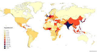
Population density is a measurement of population per unit land area. It is mostly applied to humans, but sometimes to other living organisms too. It is a key geographical term.
Lapu-Lapu City, officially the City of Lapu-Lapu, is a 1st class highly urbanized city in the Central Visayas region of the Philippines. According to the 2020 census, it has a population of 497,604.

Mandaue, officially the City of Mandaue, is a 1st class highly urbanized city in the Central Visayas region of the Philippines. According to the 2020 census, it has a population of 364,116 people.

A landmass, or land mass, is a large region or area of land that is in one piece and not broken up by oceans. The term is often used to refer to lands surrounded by an ocean or sea, such as a continent or a large island. In the field of geology, a landmass is a defined section of continental crust extending above sea level.

Metropolitan France, also known as European France, is the area of France which is geographically in Europe. This collective name for the European regions of France is used in everyday life in France but has no administrative meaning, with the exception of only Metropolitan France being part of the Schengen Area. Indeed, the overseas regions have exactly the same administrative status as the metropolitan regions. Metropolitan France comprises mainland France and Corsica, as well as nearby French islands in the Atlantic Ocean, the English Channel, and the Mediterranean Sea. Its borders have undergone significant changes over the centuries, particularly in the east, but have remained unaltered since 1947.

Antártica Chilena Province is the southernmost of the four provinces in Chile's southernmost region, Magallanes and Antártica Chilena Region (XII). The capital is Puerto Williams. The province comprises the extreme southern part of Isla Grande de Tierra del Fuego, the islands south and west of Isla Grande, and Chile's claims in Antarctica. The province is administratively divided into two communes (comunas): Cabo de Hornos, located at the southern tip of South America, and Antártica, a wedge-shaped claim of Antarctica, which is not internationally recognized. Its total area of 1,265,853.7 km2 (488,749 sq mi) makes it almost twice as large as all other provinces of Chile combined.

Geography of Asia reviews geographical concepts of classifying Asia, the central and eastern part of Eurasia, comprising 58 countries and territories.

Cordova, officially the Municipality of Cordova, is a 1st class municipality in the province of Cebu, Philippines. According to the 2020 census, it has a population of 70,595 people.
Caluya, officially the Municipality of Caluya, is a 1st class municipality in the province of Antique, Philippines. According to the 2020 census, it has a population of 38,908 people, making it the sixth most populous municipality in the province.

Singapore Island, also known as mainland Singapore, is the main constituent island of the sovereign island country and city-state of the Republic of Singapore. It is located at the southern tip of Malay Peninsula, in-between the Straits of Malacca and the South China Sea. The Singapore Strait lies to the south, while the Johor Strait lies to the north.

Tricontinental Chile is a geopolitical concept denoting Chile's unique position with its mainland in South America, Easter Island in Oceania (Polynesia) and the Chilean Antarctic Territory in Antarctica. This concept is built on the basis that there are Chilean territories as far away from the mainland as to be considered part of Polynesia and on a larger scale, Oceania, and Chile's claims to Antarctica provide it a basis for claiming to be a part of Antarctica as well.

The geography of Australia encompasses a wide variety of biogeographic regions being the world's smallest continent, while comprising the territory of the sixth-largest country in the world. The population of Australia is concentrated along the eastern and south-eastern coasts. The geography of the continent is extremely diverse, ranging from the snow-capped mountains of the Australian Alps and Tasmania to large deserts, tropical and temperate forests, grasslands, heathlands and woodlands.

Zealandia, also known as Te Riu-a-Māui (Māori) or Tasmantis, is an almost entirely submerged mass of continental crust in Oceania that subsided after breaking away from Gondwana 83–79 million years ago. It has been described variously as a submerged continent, continental fragment, and microcontinent. The name and concept for Zealandia was proposed by Bruce Luyendyk in 1995, and satellite imagery shows it to be almost the size of Australia. A 2021 study suggests Zealandia is over a billion years old, about twice as old as geologists previously thought.

A continent is any of several large geographical regions. Continents are generally identified by convention rather than any strict criteria. A continent could be a single landmass or a part of a very large landmass, as in the case of Asia or Europe. Due to this, the number of continents varies; up to seven or as few as four geographical regions are commonly regarded as continents. Most English-speaking countries recognize seven regions as continents. In order from largest to smallest in area, these seven regions are Asia, Africa, North America, South America, Antarctica, Europe, and Australia. Different variations with fewer continents merge some of these regions; examples of this are merging North America and South America into America, Asia and Europe into Eurasia, and Africa, Asia, and Europe into Afro-Eurasia.

The continent of Australia, sometimes known in technical contexts by the names Sahul, Australia-New Guinea, Australinea, or Meganesia to distinguish it from the country of Australia, is located within the Southern and Eastern hemispheres. The continent includes mainland Australia, Tasmania, the island of New Guinea, the Aru Islands, the Ashmore and Cartier Islands, most of the Coral Sea Islands, and some other nearby islands. Situated in the geographical region of Oceania, Australia is the smallest of the seven traditional continents.

A submerged continent or a sunken continent is a region of continental crust, extensive in size but mainly undersea. The terminology is used by some paleogeologists and geographers in reference to some landmasses.

Central Visayas is an administrative region in the Philippines, numerically designated as Region VII. It consists of four provinces: Cebu, Bohol, Negros Oriental, and Siquijor. The region also has three highly urbanized cities: Cebu City, Lapu-Lapu, and Mandaue.
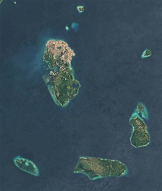
Bungin Island is located in Alas District, Sumbawa Regency, West Nusa Tenggara in Indonesia. The island is situated within Bali Sea, 70 kilometers west of the center of Sumbawa Besar district. The island is administratively one of the villages in the district. The island is mostly inhabited by the Bajo people from South Sulawesi, who arrived here more than 200 years ago. During that time they built up with material from the seabed what had been a sandy shoal of an estimated 400 square metres (4,300 sq ft) into an area of around 8.5 hectares where about 3,400 people live, making Pulau Bungin among the densest-populated islands in the world) in pile dwellings shored up with harvested coral stone. Goats are kept on land, and fish are harvested from the surrounding waters with harpoon guns. The island is connected by a causeway to the mainland of the regency. The island is.