List of islands of Hawaii

Last updated

Islands of the state of Hawaii
Native name:
Mokupuni o Hawai‘i
Map of USA HI full.png
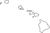
Location of Hawaii within the United States
Geography
Location North Pacific
Archipelago Hawaiian Islands
Total islandsApproximately 1347 Islands (including 4 of the Midway Atoll)
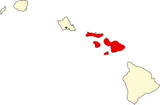
Major islands Hawaiʻi, Maui, Kahoʻolawe. Lānaʻi, Molokaʻi, Oʻahu, Kauaʻi, Niʻihau
Area6,423 sq mi (16,640 km2)
Length1,500 mi (2400 km)
Coastline750 mi (1210 km)
Highest point13,796 ft (4,205 m) (Mauna Kea)
Administration
United States
State Hawaii (excluding the federally governed Midway Atoll)
Demographics
Population247,456,789 (2020)

The following is a list of the islands in Hawaii. The state of Hawaii, consisting of the Hawaiian Islands, has the fourth-longest ocean coastline of the 50 states (after Alaska, Florida, and California) at 750 miles (1,210 km). It is the only state that consists entirely of islands, with 6,422.62 sq mi (16,634.5 km2) of land. The Hawaiian Island archipelago extends some 1,500 miles (2,400 km) from the southernmost island of Hawaiʻi to the northernmost Kure Atoll. Despite being within the boundaries of Hawaii, Midway Atoll, comprising several smaller islands, is not included as an island of Hawaii, because it is classified as a United States Minor Outlying Islands and is therefore administered by the federal government and not the state.

Contents

Hawaii is divided into five counties: Hawaiʻi, Honolulu, Kalawao, Kauaʻi, and Maui. Each island is included in the boundaries and under the administration of one of these counties. Honolulu County, despite being centralized, administers the outlying Northwestern Hawaiian Islands. Kalawao (the smallest county in the United States in terms of land area) and Maui, both occupying the island of Molokaʻi, are the only counties that share the same island. Hawaii is typically recognized by its eight main islands: Hawaiʻi, Maui, Kahoʻolawe, Lānaʻi, Molokaʻi, Oʻahu, Kauaʻi, and Niʻihau.

The state of Hawaii officially recognizes only 137 islands in the state which includes four islands of the Midway Atoll. [1] An island in this sense may also include much smaller and typically uninhabited islets, rocks, coral reefs, and atolls. For that reason, this article lists 152 separate islands (but also names smaller island chains such as the French Frigate Shoals, which includes 13 islands of its own). Some of these are too small to appear on maps, and others, such as Maro Reef, only appear above the water's surface during times of low tide. Others, such as Shark and Skate islands, have completely eroded away.

The majority of the Hawaiian Islands are uninhabited, with Niʻihau being the westernmost island with a population of around 130 natives, no one else is allowed on the island. All the islands west of Niʻihau—those categorized as the Northwestern Hawaiian Islands—are unpopulated and recently incorporated into the Papahānaumokuākea Marine National Monument. The island of Oʻahu has just over one million residents (about 70% of the state's population), and the island of Hawaiʻi is by far the largest island with an area of 4,028 sq mi (10,430 km2)—62.7% of the state's land area. The islands were first settled as early as AD 300 by Polynesian long-distance navigators. British captain James Cook was the first European to land on the islands in January 1778. [2] The islands, which were governed independently up until 1898 were then annexed by the United States as a territory from 1898 to 1959. On August 21, 1959, they were collectively admitted as the 50th state.

The islands are the exposed peaks of a great undersea mountain range known as the Hawaiian–Emperor seamount chain, formed by volcanic activity over a hotspot in the Earth's mantle. The archipelago formed as the Pacific plate moved slowly northwestward over a hotspot in the mantle at about 32 miles (51 km) per million years. The islands in the northwest of the archipelago are older and typically smaller, due to longer exposure to erosion. The age of the archipelago has been estimated using potassium-argon dating methods. [3] It is estimated that the northwesternmost Kure Atoll is the oldest at approximately 28 million years, while the southeasternmost Hawaiʻi Island is approximately 400,000 years old and still subjected to ongoing volcanism—one of the most active hotspots on Earth. [4] [5]

Hawaiʻi County

Hawai`i County Map of Hawaii highlighting Hawaii County.svg
Hawaiʻi County

Hawaiʻi County centers on Hawaiʻi Island. With an area of 4,028 sq mi (10,430 km2), it is larger than all of the other islands of Hawaii combined, encompassing approximately 62.7% of the entire state's land area. It is also the largest island in the United States. In modern times, Hawaiʻi is known commonly as the "Big Island" to reduce confusion between the island and the state itself. The island also contains the state's highest peak: Mauna Kea at 13,803 feet (4,207 m). Hawaiʻi County as a whole has 27 islands and a total population of 185,079.

IslandCoordinates
Arched Rock 19°14′04″N155°54′03″W / 19.23444°N 155.90090°W / 19.23444; -155.90090 (Arched Rock)
Coconut Island (Moku Ola) 19°43′57″N155°04′17″W / 19.73250°N 155.07139°W / 19.73250; -155.07139 (Coconut Island)
Hawaiʻi 19°30′02″N155°30′02″W / 19.50056°N 155.50056°W / 19.50056; -155.50056 (Hawaiʻi Island)
Kalaemano 19°28′48″N155°56′15″W / 19.48005°N 155.93738°W / 19.48005; -155.93738 (Kalaemano)
Kaluahee Rock 19°17′32″N155°53′29″W / 19.29222°N 155.89130°W / 19.29222; -155.89130 (Kaluahee Rock)
Kaopapa 19°28′06″N155°55′30″W / 19.46833°N 155.92500°W / 19.46833; -155.92500 (Kaopapa)
Kauhuula 19°10′51″N155°25′27″W / 19.18083°N 155.42417°W / 19.18083; -155.42417 (Kauhuula)
Kaulaʻināiwi Island 19°44′06″N155°04′21″W / 19.73500°N 155.07250°W / 19.73500; -155.07250 (Kaulaʻināiwi Island)
Kawelohea 19°05′09″N155°33′13″W / 19.08583°N 155.55361°W / 19.08583; -155.55361 (Kawelohea)
Keaoi Island 19°16′15″N155°15′24″W / 19.27083°N 155.25667°W / 19.27083; -155.25667 (Keaoi Island)
Kipu Rock 19°26′48″N155°55′24″W / 19.44667°N 155.92333°W / 19.44667; -155.92333 (Kipu Rock)
Kuhulu Rock 19°17′24″N155°53′33″W / 19.29000°N 155.89250°W / 19.29000; -155.89250 (Kuhulu Rock)
Laahana 19°11′36″N155°23′58″W / 19.19333°N 155.39944°W / 19.19333; -155.39944 (Laahana)
Lepeamoa Rock 19°20′22″N155°53′17″W / 19.33944°N 155.88806°W / 19.33944; -155.88806 (Lepeamoa Rock)
Mahikea Island 19°44′16″N155°01′54″W / 19.73778°N 155.03167°W / 19.73778; -155.03167 (Mahikea Island)
Mokuhonu 18°56′49″N155°41′52″W / 18.94694°N 155.69778°W / 18.94694; -155.69778 (Mokuhonu)
Mokuokahailani Rock 19°10′57″N155°26′12″W / 19.18250°N 155.43667°W / 19.18250; -155.43667 (Mokuokahailani Rock)
Mokupuku 20°11′43″N155°42′09″W / 20.19528°N 155.70250°W / 20.19528; -155.70250 (Mokupuku)
Opihi Rock 19°34′57″N154°54′53″W / 19.58250°N 154.91472°W / 19.58250; -154.91472 (Opihi Rock)
Paʻakea 18°58′10″N155°36′52″W / 18.96944°N 155.61444°W / 18.96944; -155.61444 (Paʻakea)
Paokalani Island 20°11′42″N155°42′19″W / 20.19500°N 155.70528°W / 20.19500; -155.70528 (Paokalani Island)
Pohakulua 19°55′00″N155°53′51″W / 19.91667°N 155.89750°W / 19.91667; -155.89750 (Pohakulua)
Pulehua Island 18°58′00″N155°37′23″W / 18.96667°N 155.62306°W / 18.96667; -155.62306 (Pulehua Island)
Reeds Island 19°43′38″N155°05′53″W / 19.72722°N 155.09806°W / 19.72722; -155.09806 (Reeds Island)
Wahinemakanui 19°39′55″N154°58′45″W / 19.66528°N 154.97917°W / 19.66528; -154.97917 (Wahinemakanui)

Honolulu County

Honolulu County Map of Hawaii highlighting Honolulu County.svg
Honolulu County

Known officially as the City and County of Honolulu, the county includes both the urban district of Honolulu (the state's largest city and capital) and the rest of the island of Oʻahu, as well as several minor surrounding islands. The county also administers the Northwestern Hawaiian Islands with the exception of the federal governed Midway Atoll. The county's population in 2010 was 953,207, making it the 43rd most populated county in the United States. At 596.7 sq mi (1,545 km2), the island of Oʻahu is the third largest island and also the most populated, accounting for approximately 70% of the entire state's population. The county as a whole has 63 islands, and 32 of those belong to the Northwestern Hawaiian Islands.

IslandCoordinates
Ahu O Laka Island 21°27′59″N157°48′37″W / 21.46639°N 157.81028°W / 21.46639; -157.81028 (Ahu O Laka Island)
Banzai Rocks 21°39′50″N158°03′35″W / 21.66389°N 158.05972°W / 21.66389; -158.05972 (Banzai Rocks)
Coconut Island (Mokuoloe) 21°26′01″N157°47′18″W / 21.43361°N 157.78833°W / 21.43361; -157.78833 (Coconut Island)
Coral Island 21°27′01″N157°47′12″W / 21.45028°N 157.78667°W / 21.45028; -157.78667 (Coral Island)
Ford Island 21°22′00″N157°57′53″W / 21.36667°N 157.96472°W / 21.36667; -157.96472 (Ford Island)
Kaohikaipu Island 21°19′25″N157°39′33″W / 21.32361°N 157.65917°W / 21.32361; -157.65917 (Kaohikaipu Island)
Khewa Moku 21°40′32″N157°55′36″W / 21.67556°N 157.92667°W / 21.67556; -157.92667 (Khewa Moku)
Kūkaimanini Island 21°41′47″N158°01′26″W / 21.69639°N 158.02389°W / 21.69639; -158.02389 (Kūkaimanini Island)
Kahakaʻaulana Island 21°18′47″N157°53′53″W / 21.31306°N 157.89806°W / 21.31306; -157.89806 (Kahakaʻaulana Island)
Kapapa Island 21°28′48″N157°48′05″W / 21.48000°N 157.80139°W / 21.48000; -157.80139 (Kapapa Island)
Kekepa Island 21°27′54″N157°46′41″W / 21.46500°N 157.77806°W / 21.46500; -157.77806 (Kekepa Island)
Kukuihoʻolua 21°39′12″N157°54′58″W / 21.65333°N 157.91611°W / 21.65333; -157.91611 (Kukuihoʻolua)
Laulaunui Island 21°22′01″N158°00′57″W / 21.36694°N 158.01583°W / 21.36694; -158.01583 (Laulaunui Island)
Mōkōlea Rock 21°26′06″N157°43′20″W / 21.43500°N 157.72222°W / 21.43500; -157.72222 (Mōkōlea Rock)
Mānana Island 21°19′54″N157°39′35″W / 21.33167°N 157.65972°W / 21.33167; -157.65972 (Mānana Island)
Mokauea Island 21°18′41″N157°53′42″W / 21.31139°N 157.89500°W / 21.31139; -157.89500 (Mokauea Island)
Mokoliʻi 21°30′46″N157°49′57″W / 21.51278°N 157.83250°W / 21.51278; -157.83250 (Mokoliʻi)
Mokuʻlai 21°39′07″N157°54′43″W / 21.65194°N 157.91194°W / 21.65194; -157.91194 (Mokuʻlai)
Mokuaia Island 21°39′57″N157°55′32″W / 21.66583°N 157.92556°W / 21.66583; -157.92556 (Mokuaia Island)
Mokuauia (Goat Island) 21°39′57″N157°55′32″W / 21.66583°N 157.92556°W / 21.66583; -157.92556 (Mokuauia)
Moku Moʻo 21°23′33″N157°48′27″W / 21.39250°N 157.80750°W / 21.39250; -157.80750 (Moku Moʻo)
Moku Iki 21°22′16″N157°57′01″W / 21.37111°N 157.95028°W / 21.37111; -157.95028 (Moku Iki)
Mokulua Islands 21°23′42″N157°42′04″W / 21.39500°N 157.70111°W / 21.39500; -157.70111 (Mokulua Islands)
Moku Manu 21°28′23″N157°43′23″W / 21.47306°N 157.72306°W / 21.47306; -157.72306 (Moku Manu)
Mokumanu Islands 21°28′00″N157°43′00″W / 21.46667°N 157.71667°W / 21.46667; -157.71667 (Mokumanu Islands)
Moku Nui 21°22′16″N157°57′08″W / 21.37111°N 157.95222°W / 21.37111; -157.95222 (Moku Nui)
Mokuoeo Island 21°18′44″N157°54′19″W / 21.31222°N 157.90528°W / 21.31222; -157.90528 (Mokuoeo Island)
Oʻahu 21°26′00″N157°58′00″W / 21.43333°N 157.96667°W / 21.43333; -157.96667 (Oʻahu)
Pōhaku Kulaʻilaʻi 21°31′48″N158°13′58″W / 21.53000°N 158.23278°W / 21.53000; -158.23278 (Pōhaku Kulaʻilaʻi)
Papaʻamoi Island 21°42′19″N158°00′45″W / 21.70528°N 158.01250°W / 21.70528; -158.01250 (Papaʻamoi Island)
Popoia Island 21°24′11″N157°43′24″W / 21.40306°N 157.72333°W / 21.40306; -157.72333 (Popoia Island)
Pulemoku 21°39′46″N157°55′05″W / 21.66278°N 157.91806°W / 21.66278; -157.91806 (Pulemoku)
Sand Island 21°18′30″N157°53′00″W / 21.30833°N 157.88333°W / 21.30833; -157.88333 (Sand Island)
Wānanapaoa Islands 21°38′31″N158°04′21″W / 21.64194°N 158.07250°W / 21.64194; -158.07250 (Wānanapaoa Islands)

Northwestern Hawaii Islands

Northwestern Hawaiian Islands Hawaiianislandchain USGS.png
Northwestern Hawaiian Islands

The Northwestern Hawaiian Islands (also known as the Leeward Islands) are the small islands and atolls in the Hawaiian island chain located northwest of the larger islands of Kauaʻi and Niʻihau. For administrative purposes, all of these islands are controlled by Honolulu County. The Northwestern Hawaiian Islands consist of nine main islands and innumerable islets, coral reefs, atolls, sandbar, and intermittent islands—some of which are officially named. All of these islands account for only 3.1075 sq mi (8.048 km2) and have no permanent residents.

Midway Atoll, sometimes referred to as Midway Island, is a 2.4 sq mi (6.2 km2) archipelago. For quite some time, it had a permanent population of naval personnel. It is one of the northwesternmost islands, located 161 miles (259 km) east of the International Date Line. Kure Atoll is the only island west at 55 miles (89 km) beyond Midway Atoll. It also observes a different time zone (Samoa Time Zone) than the rest of the Hawaiian Islands. Because of its strong military history, Midway Atoll is classified as a Minor Outlying Island, an unorganized territory of the United States and is therefore not under the jurisdiction of Hawaii. Midway Atoll consists of four individual islands.

  Indicates an island that is part of the Midway Atoll
IslandCoordinates
Bare Island 23°44′53″N166°08′53″W / 23.74809°N 166.14808°W / 23.74809; -166.14808 (Bare Island)
Bird Island 27°47′04″N175°50′10″W / 27.78444°N 175.83611°W / 27.78444; -175.83611 (Bird Island)
Disappearing Island 23°42′58″N166°08′10″W / 23.71601°N 166.13602°W / 23.71601; -166.13602 (Disappearing Island)
Eastern Island 28°12′35″N177°19′46″W / 28.20985°N 177.32933°W / 28.20985; -177.32933 (Eastern Island)
East Island 23°44′48″N166°08′58″W / 23.74675°N 166.14954°W / 23.74675; -166.14954 (East Island)
French Frigate Shoals 23°44′56″N166°08′46″W / 23.74889°N 166.14611°W / 23.74889; -166.14611 (French Frigate Shoals)
Gardner Pinnacles 25°00′01″N167°55′00″W / 25.00028°N 167.91667°W / 25.00028; -167.91667 (Gardner Pinnacles)
Gin Island 23°44′13″N166°08′23″W / 23.73693°N 166.13967°W / 23.73693; -166.13967 (Gin Island)
Grass Island 27°45′55″N175°54′02″W / 27.76528°N 175.90056°W / 27.76528; -175.90056 (Grass Island)
Green Island 28°23′40″N178°17′51″W / 28.39444°N 178.29750°W / 28.39444; -178.29750 (Grass Island)
Hermes Atoll 27°50′00″N175°50′00″W / 27.83333°N 175.83333°W / 27.83333; -175.83333 (Hermes Atoll)
Kittery Island 27°45′28″N175°56′25″W / 27.75778°N 175.94028°W / 27.75778; -175.94028 (Kittery Island)
Kure Atoll 28°25′00″N178°20′00″W / 28.41667°N 178.33333°W / 28.41667; -178.33333 (Kure Atoll)
Laysan Island 25°46′15″N171°44′15″W / 25.77083°N 171.73750°W / 25.77083; -171.73750 (Laysan Island)
La Perouse Pinnacle 23°44′50″N166°09′32″W / 23.74714°N 166.15881°W / 23.74714; -166.15881 (Le Perouse Pinnacle)
Lisianski Island 26°02′00″N174°00′01″W / 26.03333°N 174.00028°W / 26.03333; -174.00028 (Lisianski Island)
Little Gin Island 23°44′06″N166°08′18″W / 23.73489°N 166.13821°W / 23.73489; -166.13821 (Little Gin Island)
Little North Island 27°54′10″N175°44′16″W / 27.90278°N 175.73778°W / 27.90278; -175.73778 (Little North Island)
Maro Reef 25°24′54″N170°35′24″W / 25.41500°N 170.59000°W / 25.41500; -170.59000 (Maro Reef)
Midway Atoll 28°14′12″N177°22′15″W / 28.23660°N 177.37092°W / 28.23660; -177.37092 (Midway Atoll)
Mullet Island 23°45′36″N166°09′20″W / 23.75987°N 166.15563°W / 23.75987; -166.15563 (Mullet Island)
Necker Island 23°35′00″N164°42′00″W / 23.58333°N 164.70000°W / 23.58333; -164.70000 (Necker Island)
Nihoa 23°06′00″N161°58′00″W / 23.10000°N 161.96667°W / 23.10000; -161.96667 (Nihoa)
North Island 27°55′00″N175°44′00″W / 27.91667°N 175.73333°W / 27.91667; -175.73333 (North Island)
Pearl Atoll 27°50′00″N175°50′00″W / 27.83333°N 175.83333°W / 27.83333; -175.83333 (Pearl Atoll)
Round Island 23°45′34″N166°09′26″W / 23.75953°N 166.15714°W / 23.75953; -166.15714 (Round Island)
Sand Island1 28°12′34″N177°22′43″W / 28.20955°N 177.37851°W / 28.20955; -177.37851 (Sand Island (Midway Atoll))
Sand Island2 27°47′09″N175°51′40″W / 27.78583°N 175.86111°W / 27.78583; -175.86111 (Sand Island)
Seal Island 27°45′09″N175°56′05″W / 27.75250°N 175.93472°W / 27.75250; -175.93472 (Seal Island)
Shark Island 23°45′38″N166°10′00″W / 23.76042°N 166.16679°W / 23.76042; -166.16679 (Shark Island)
Skate Island 23°45′55″N166°09′28″W / 23.76535°N 166.15765°W / 23.76535; -166.15765 (Skate Island)
Spit Island 28°12′23″N177°20′59″W / 28.20637°N 177.34967°W / 28.20637; -177.34967 (Spit Island)
Southeast Island 27°46′51″N175°48′42″W / 27.78083°N 175.81167°W / 27.78083; -175.81167 (Southeast Island)
Tern Island 23°45′45″N166°09′55″W / 23.76238°N 166.16516°W / 23.76238; -166.16516 (Tern Island)
Trig Island 23°45′52″N166°09′41″W / 23.76456°N 166.16126°W / 23.76456; -166.16126 (Trig Island)
Whale Island 23°45′57″N166°09′28″W / 23.76589°N 166.15773°W / 23.76589; -166.15773 (Whale Island)
Shallow Islandn/a
Near Island
Ocean Island

Kalawao County

Kalawao County Map of Hawaii highlighting Kalawao County.svg
Kalawao County

Kalawao County contains no individual islands of its own. With a census population of 90, the county is the country's smallest county in terms of population with 44 fewer residents than Loving County, Texas. At 13.21 sq mi (34.2 km2), it is the smallest county by land area in the United States and is often omitted from maps. Kalawao County shares the island of Molokaʻi with Maui County and occupies only 5% of the island's 260 sq mi (670 km2) and 1.2% of the island's 7,404 residents.

IslandCoordinates
Molokai 21°11′49″N156°58′02″W / 21.19694°N 156.96722°W / 21.19694; -156.96722 (Molokaʻi (Kalawao County))
Mōkapu 21°11′12″N156°55′37″W / 21.18667°N 156.92694°W / 21.18667; -156.92694 (Mākapu Island)
Huelo 21°10′27″N156°55′09″W / 21.17417°N 156.91917°W / 21.17417; -156.91917 (Huelo)
ʻOkala Island 21°10′40″N156°55′55″W / 21.17778°N 156.93194°W / 21.17778; -156.93194 (Okala Island)

Kauaʻi County

Kaua`i County Map of Hawaii highlighting Kauai County.svg
Kauaʻi County

Kauaʻi County is the northwesternmost county (excluding the Northwestern Hawaiian Islands) in the state. It occupies the two main islands of Kauaʻi and Niʻihau. Kauai is fourth largest island in the Hawaiian archipelago at 562.3 sq mi (1,456 km2). With a population of 58,303 (2000), it holds 99.7% of the county's population of 58,463. The remaining 160 residents reside on Niʻihau. Lehua and Kaʻula are the third and fourth largest islands, although they are very small and uninhabited. Kaʻula is the westernmost of the Hawaiian Islands not included in the Northwestern Hawaiian Island chain. The county as a whole has eight islands.

IslandCoordinates
Kaʻula 21°39′40″N160°32′30″W / 21.66111°N 160.54167°W / 21.66111; -160.54167 (Kaʻula)
Kalanipuao Rock 21°52′55″N159°31′33″W / 21.88194°N 159.52583°W / 21.88194; -159.52583 (Kalanipuao Rock)
Kauaʻi 21°56′37″N159°29′38″W / 21.94361°N 159.49389°W / 21.94361; -159.49389 (Kauaʻi)
Kuakamoku Rock 21°53′36″N160°13′11″W / 21.89333°N 160.21972°W / 21.89333; -160.21972 (Kuakamoku Rock)
Lehua 22°01′10″N160°06′02″W / 22.01944°N 160.10056°W / 22.01944; -160.10056 (Lehua)
Mokuaeae 22°14′16″N159°24′20″W / 22.23778°N 159.40556°W / 22.23778; -159.40556 (Mokuaeae)
Niʻihau 21°54′24″N160°08′57″W / 21.90667°N 160.14917°W / 21.90667; -160.14917 (Niʻihau)
Puʻukole 22°00′27″N160°05′49″W / 22.00750°N 160.09694°W / 22.00750; -160.09694 (Puʻukole)

Maui County

Maui County Map of Hawaii highlighting Maui County.svg
Maui County

Maui County consists of four of the state's main islands: Maui, Kahoʻolawe, Lānaʻi, and Molokaʻi. With a land area of 1,159.20 sq mi (3,002.3 km2), it had a population of 154,834 in 2000. The island of Maui has the most residents at 117,644 (76% of the county's population). It is also the largest of the county's islands with 727.2 sq mi (1,883 km2) of land—the state's second largest island and the 17th largest in the country. At 44.6 sq mi (116 km2), Kahoʻolawe is the state's largest island with no permanent inhabitants. Lānaʻi has a population of 3,193; Molokaʻi has a population of 7,404. Molokaʻi is the only island in Hawaii that is divided between two counties. With a population of 90, Kalawao County occupies a tiny 13.21 sq mi (34.2 km2) portion on the northern shore of the island. Maui County contains 59 named islands.

IslandCoordinates
Āhole Rock 20°38′59″N156°03′27″W / 20.64972°N 156.0575°W / 20.64972; -156.0575 (Āhole Rock)
Ālau Island 20°43′53″N155°58′49″W / 20.73139°N 155.98028°W / 20.73139; -155.98028 (Alau Island)
Aawaiki 20°57′58″N156°31′26″W / 20.96611°N 156.52389°W / 20.96611; -156.52389 (Aawaiki)
Aawanui 20°57′50″N156°31′19″W / 20.96389°N 156.52194°W / 20.96389; -156.52194 (Aawanui)
Aluea Rocks 20°50′58″N156°07′32″W / 20.84944°N 156.12556°W / 20.84944; -156.12556 (Aluea Rocks)
Haukoʻi 21°10′05″N156°53′54″W / 21.16806°N 156.89833°W / 21.16806; -156.89833 (Haukoʻi)
Hulu Island 20°57′40″N156°31′10″W / 20.96111°N 156.51944°W / 20.96111; -156.51944 (Hulu Island)
Kaelua 20°49′51″N156°05′55″W / 20.83083°N 156.09861°W / 20.83083; -156.09861 (Kaelua)
Kahʻlau 20°53′55″N156°11′49″W / 20.89861°N 156.19694°W / 20.89861; -156.19694 (Kahʻlau)
Kahoʻolawe 20°33′00″N156°36′00″W / 20.55000°N 156.60000°W / 20.55000; -156.60000 (Kahoʻolawe)
Kalaepohaku 20°46′56″N156°27′50″W / 20.78222°N 156.46389°W / 20.78222; -156.46389 (Kalaepohaku)
Kanahā Rock 21°08′02″N156°42′28″W / 21.13389°N 156.70778°W / 21.13389; -156.70778 (Kanahā Rock)
Kaneapua 20°44′14″N156°58′08″W / 20.73722°N 156.96889°W / 20.73722; -156.96889 (Kaneapua)
Moku o Kau 20°54′28″N156°12′38″W / 20.90778°N 156.21056°W / 20.90778; -156.21056 (Moku o Kau)
Kauwalu 20°51′33″N156°07′56″W / 20.85917°N 156.13222°W / 20.85917; -156.13222 (Kauwalu)
Keʻpuka Rock 20°52′44″N156°10′31″W / 20.87889°N 156.17528°W / 20.87889; -156.17528 (Keʻpuka Rock)
Kukuipalaoa 21°10′19″N156°49′51″W / 21.17194°N 156.83083°W / 21.17194; -156.83083 (Kukuipalaoa)
Lānaʻi 20°50′30″N156°55′04″W / 20.84167°N 156.91778°W / 20.84167; -156.91778 (Lānaʻi)
Laupapa Rock 20°41′31″N156°00′30″W / 20.69194°N 156.00833°W / 20.69194; -156.00833 (Laupapa Rock)
Mākālea Rock 21°10′43″N156°53′20″W / 21.17861°N 156.88889°W / 21.17861; -156.88889 (Mākōlea Rock)
Mākoholā Island 21°10′29″N156°52′46″W / 21.17472°N 156.87944°W / 21.17472; -156.87944 (Mākoholā Island)
Mahinanui 20°59′55″N156°32′38″W / 20.99861°N 156.54389°W / 20.99861; -156.54389 (Mahinanui)
Makoloaka Island 20°50′29″N156°07′26″W / 20.84139°N 156.12389°W / 20.84139; -156.12389 (Makoloaka Island)
Maui 20°34′55″N156°22′30″W / 20.58194°N 156.37500°W / 20.58194; -156.37500 (Maui)
Mokeehia Island 20°59′11″N156°31′33″W / 20.98636°N 156.52586°W / 20.98636; -156.52586 (Mokeehia Island)
Mokuʻula 20°52′18″N156°40′40″W / 20.87167°N 156.67778°W / 20.87167; -156.67778 (Mokuʻula)
Mokuhālua 20°52′00″N156°09′14″W / 20.86667°N 156.15389°W / 20.86667; -156.15389 (Mokuhālua)
Mokuhala 20°51′43″N156°08′12″W / 20.86194°N 156.13667°W / 20.86194; -156.13667 (Mokuhala)
Mokuhoʻoniki 21°08′09″N156°42′21″W / 21.13583°N 156.70583°W / 21.13583; -156.70583 (Mokuhoʻoniki)
Mokuhuki 20°49′51″N156°07′06″W / 20.83083°N 156.11833°W / 20.83083; -156.11833 (Mokuhuki)
Mokulau 20°38′24″N156°06′48″W / 20.64000°N 156.11333°W / 20.64000; -156.11333 (Mokulau)
Mokumana 20°51′46″N156°08′01″W / 20.86278°N 156.13361°W / 20.86278; -156.13361 (Mokumana)
Mokumanu 21°10′21″N156°53′28″W / 21.17250°N 156.89111°W / 21.17250; -156.89111 (Mokumanu)
Mokupala 20°42′27″N155°59′47″W / 20.70750°N 155.99639°W / 20.70750; -155.99639 (Mokupala)
Mokupapa1 20°39′03″N156°03′39″W / 20.65083°N 156.06083°W / 20.65083; -156.06083 (Mokupapa)
Mokupapa2 20°49′41″N156°04′58″W / 20.82806°N 156.08278°W / 20.82806; -156.08278 (Mokupapa)
Mokupapapa 21°09′45″N156°43′58″W / 21.16250°N 156.73278°W / 21.16250; -156.73278 (Mokupapapa)
Mokupipi 20°49′40″N156°04′57″W / 20.82778°N 156.08250°W / 20.82778; -156.08250 (Mokupipi)
Molokaʻi 20°43′53″N155°58′49″W / 20.73139°N 155.98028°W / 20.73139; -155.98028 (Molokaʻi)
Molokini 20°38′01″N156°29′50″W / 20.63361°N 156.49722°W / 20.63361; -156.49722 (Molokini)
Moku Naio 20°44′28″N156°58′10″W / 20.74111°N 156.96944°W / 20.74111; -156.96944 (Moku Naio)
Namoku 21°12′31″N156°59′17″W / 21.20861°N 156.98806°W / 21.20861; -156.98806 (Namoku)
Nanahoa 20°49′43″N156°59′43″W / 20.82861°N 156.99528°W / 20.82861; -156.99528 (Nanahoa)
Pāʻāonuʻakea 21°10′00″N156°54′01″W / 21.16667°N 156.90028°W / 21.16667; -156.90028 (Pāʻāonuʻakea)
Pai Island 20°49′14″N156°04′09″W / 20.82056°N 156.06917°W / 20.82056; -156.06917 (Pai Island)
Papaloa 20°45′32″N155°58′53″W / 20.75889°N 155.98139°W / 20.75889; -155.98139 (Papaloa)
Papanui o Kane 20°56′55″N156°16′50″W / 20.94861°N 156.28056°W / 20.94861; -156.28056 (Papanui o Kane)
Pohaku Manamana 20°35′00″N156°20′37″W / 20.58333°N 156.34361°W / 20.58333; -156.34361 (Pohaku Manamana)
Pohaku Paea 20°35′53″N156°26′09″W / 20.59806°N 156.43583°W / 20.59806; -156.43583 (Pohaku Paea)
Poopoo 20°44′19″N156°55′25″W / 20.73861°N 156.92361°W / 20.73861; -156.92361 (Poopoo)
Puāukiʻi Island 20°45′37″N155°58′57″W / 20.76028°N 155.98250°W / 20.76028; -155.98250 (Puʻukiʻi Island)
Puāukoaʻe 20°30′50″N156°36′48″W / 20.51389°N 156.61333°W / 20.51389; -156.61333 (Puʻukoaʻe)
Puupehe 20°44′15″N156°53′35″W / 20.73750°N 156.89306°W / 20.73750; -156.89306 (Puupehe)
Twin Rocks 20°45′43″N155°58′48″W / 20.76194°N 155.98000°W / 20.76194; -155.98000 (Twin Rocks)
Waiʻāpae 20°37′40″N156°12′37″W / 20.62778°N 156.21028°W / 20.62778; -156.21028 (Waiʻāpae)
Waiakapuhi 20°34′48″N156°22′01″W / 20.58000°N 156.36694°W / 20.58000; -156.36694 (Waiakapuhi)

Related Research Articles

<span class="mw-page-title-main">Niihau</span> Westernmost and seventh largest inhabited island in Hawaiʻi

Niʻihau, anglicized as Niihau, is the westernmost main and seventh largest inhabited island in Hawaii. It is 17.5 miles (28.2 km) southwest of Kauaʻi across the Kaulakahi Channel. Its area is 69.5 square miles (180 km2). Several intermittent playa lakes provide wetland habitats for the Hawaiian coot, the Hawaiian stilt, and the Hawaiian duck. The island is designated as critical habitat for Brighamia insignis, an endemic and endangered species of Hawaiian lobelioid. The United States Census Bureau defines Niʻihau and the neighboring island and State Seabird Sanctuary of Lehua as Census Tract 410 of Kauai County, Hawaii. Its 2000 census population was 160, most of whom are native Hawaiians; its 2010 census population was 170. At the 2020 census, the population had fallen to 84.

<span class="mw-page-title-main">Nene (bird)</span> Species of bird

The nene, also known as the nēnē or the Hawaiian goose, is a species of bird endemic to the Hawaiian Islands. The nene is exclusively found in the wild on the islands of Oahu, Maui, Kauaʻi, Molokai, and Hawaiʻi. In 1957, it was designated as the official state bird of the state of Hawaiʻi.

<span class="mw-page-title-main">Hawaiian Islands</span> Archipelago in the Pacific Ocean

The Hawaiian Islands are an archipelago of eight major volcanic islands, several atolls, and numerous smaller islets in the North Pacific Ocean, extending some 1,500 miles from the island of Hawaiʻi in the south to northernmost Kure Atoll. Formerly called the Sandwich Islands by Europeans, the present name for the archipelago is derived from the name of its largest island, Hawaiʻi.

<span class="mw-page-title-main">Molokai</span> Island of the Hawaiian Islands archipelago

Molokai is the fifth most populated of the eight major islands that make up the Hawaiian Islands archipelago in the middle of the Pacific Ocean. It is 38 by 10 miles at its greatest length and width with a usable land area of 260 sq mi (673.40 km2), making it the fifth-largest in size of the main Hawaiian Islands and the 27th largest island in the United States. It lies southeast of Oʻahu across the 25 mi (40 km) wide Kaʻiwi Channel and north of Lānaʻi, separated from it by the Kalohi Channel.

Located about 2,300 miles (3,680 km) from the nearest continental shore, the Hawaiian Islands are the most isolated group of islands on the planet. The plant and animal life of the Hawaiian archipelago is the result of early, very infrequent colonizations of arriving species and the slow evolution of those species—in isolation from the rest of the world's flora and fauna—over a period of at least 5 million years. As a consequence, Hawai'i is home to a large number of endemic species. The radiation of species described by Charles Darwin in the Galapagos Islands which was critical to the formulation of his theory of evolution is far exceeded in the more isolated Hawaiian Islands.

<span class="mw-page-title-main">Kaumualiʻi</span> Aliʻi ʻAimoku of Kauaʻi and Niʻihau

Kaumualiʻi was the last independent aliʻi nui of Kauaʻi and Niʻihau before becoming a vassal of Kamehameha I within the unified Kingdom of Hawaiʻi in 1810. He was the 23rd high chief of Kauaʻi and reigned during 1794–1810.

<span class="mw-page-title-main">Hawaii State Public Library System</span> Statewide public library system in Hawaii

The Hawaii State Public Library System (HSPLS) is the only statewide public library system in the United States.

<i>Pritchardia</i> Genus of plants

The genus Pritchardia consists of between 24 and 40 species of fan palms found on tropical Pacific Ocean islands in Fiji, Samoa, Tonga, Tuamotus, and most diversely in Hawaii. The generic name honors William Thomas Pritchard (1829-1907), a British consul at Fiji.

<span class="mw-page-title-main">Maui Nui</span> Prehistoric Hawaiian island and modern biogeographic region

Maui Nui is a modern geologists' name given to a prehistoric Hawaiian island and the corresponding modern biogeographic region. Maui Nui is composed of four modern islands: Maui, Molokaʻi, Lānaʻi, and Kahoʻolawe. Administratively, the four modern islands comprise Maui County. Long after the breakup of Maui Nui, the four modern islands retained plant and animal life similar to each other. Thus, Maui Nui is not only a prehistoric island but also a modern biogeographic region.

<span class="mw-page-title-main">National Register of Historic Places listings in Hawaii</span>

This is a list of properties and historic districts in Hawaii listed on the National Register of Historic Places. More than 370 listings appear on all but one of Hawaii's main islands and the Northwestern Islands, and in all of its five counties. Included are houses, schools, archeological sites, ships, shipwrecks and various other types of listings. These properties and districts are listed by island, beginning at the northwestern end of the chain.
     This National Park Service list is complete through NPS recent listings posted May 10, 2024.

<span class="mw-page-title-main">Hawaiian lobelioids</span> Group of flowering plants

The Hawaiian lobelioids are a group of flowering plants in the bellflower family, Campanulaceae, subfamily Lobelioideae, all of which are endemic to the Hawaiian Islands. This is the largest plant radiation in the Hawaiian Islands, and indeed the largest on any island archipelago, with over 125 species. The six genera involved can be broadly separated based on growth habit: Clermontia are typically branched shrubs or small trees, up to 7 metres (23 ft) tall, with fleshy fruits; Cyanea and Delissea are typically unbranched or branching only at the base, with a cluster of relatively broad leaves at the apex and fleshy fruits; Lobelia and Trematolobelia have long thin leaves down a single, non-woody stem and capsular fruits with wind-dispersed seeds; and the peculiar Brighamia have a short, thick stem with a dense cluster of broad leaves, elongate white flowers, and capsular fruits. The relationships among the genera and sections remains unsettled as of April 2022.

<i>Wikstroemia</i> Genus of shrubs

Wikstroemia is a genus of 55-70 species of flowering shrubs and small trees in the mezereon family, Thymelaeaceae. Hawaiian species are known by the common name ‘ākia.

<span class="mw-page-title-main">Battle of Nuʻuanu</span>

The Battle of Nuʻuanu, fought in May 1795 on the southern part of the island of Oʻahu, was a key battle in the final days of King Kamehameha I's wars to conquer the Hawaiian Islands. It is known in the Hawaiian language as Kalelekaʻanae, which means "the leaping mullet", and refers to a number of Oʻahu warriors driven off the cliff in the final phase of the battle. There are "varied and sometimes conflicting histories of the Battle of Nuʻuanu."

The aliʻi nui of Kauaʻi was the sovereign king or queen of the islands of Kauaʻi and Niʻihau.

The Aliʻi nui were high chiefs of the four main Hawaiian Islands. The rulers of Molokaʻi, like those of the other Hawaiian islands, claimed descent from god Wākea.

References

  1. "Hawai'i Facts & Figures" (PDF). State of Hawaii Department of Business, Economic Development & Tourism. December 2022. Retrieved January 1, 2023.
  2. Paul Capper. "Chronology: The Third Voyage (1776–1780)". The Captain Cook Society. Retrieved March 2, 2010.
  3. "Tectonics, geochronology, and origin of the Hawaiian-Emperor Volcanic Chain" (PDF). The Geology of North America, Volume N: The Eastern Pacific Ocean and Hawaii. The Geology Society of America. 1989. Archived from the original (PDF) on June 11, 2011. Retrieved January 17, 2011.
  4. McDougall, Ian; Swanson, D. A. (1972). "Potassium-Argon Ages of Lavas from the Hawi and Pololu Volcanic Series, Kohala Volcano, Hawaii". Geological Society of America Bulletin. 83 (12): 3731–3738. doi:10.1130/0016-7606(1972)83[3731:PAOLFT]2.0.CO;2. ISSN   0016-7606 . Retrieved January 17, 2011.
  5. Clague, David A.; Dalrymple, G. Brent; Moberly, Ralph (1975). "Petrography and K-Ar Ages of Dredged Volcanic Rocks from the Western Hawaiian Ridge and the Southern Emperor Seamount Chain". Geological Society of America Bulletin. 86 (7): 991–998. doi:10.1130/0016-7606(1975)86<991:PAKAOD>2.0.CO;2. ISSN   0016-7606 . Retrieved January 17, 2011.