See also
Wikimedia Commons has media related to Rivers of Oklahoma .
This is a list of rivers in the state of Oklahoma , listed by drainage basin, alphabetically, and by size. In mean flow of water per second, the Arkansas is Oklahoma's largest river, followed by the Red River and the Neosho River.
This list is arranged by drainage basin, with respective tributaries indented under each larger stream's name.
Mean flow in cubic feet of water per second (cfs). One cubic foot equals .0283 cubic meters.
Source: "Annual Water Data Report" USGS, 2008. http://wdr.water.usgs.gov/wy2008/search.jsp; http://waterdata.usgs.gov/ok/nwis/current/?type=flow&group_key=NONE, accessed Dec 18,. 2010. Navigate to page 3 of reports of individual monitoring stations. Average Water flow statistics will vary slightly from year to year.

LeFlore County is a county along the eastern border of the U.S state of Oklahoma. As of the 2020 census, the population was 48,129. Its county seat is Poteau. The county is part of the Fort Smith metropolitan area and the name honors a Choctaw family named LeFlore. The United States District Court for the Eastern District of Oklahoma is the federal district court with jurisdiction in LeFlore County.

The Red River, or sometimes the Red River of the South to differentiate it from the Red River in the north of the continent, is a major river in the Southern United States. It was named for its reddish water color from passing through red-bed country in its watershed. It is known as the Red River of the South to distinguish it from the Red River of the North, which flows between Minnesota and North Dakota into the Canadian province of Manitoba. Although once a tributary of the Mississippi River, the Red River is now a tributary of the Atchafalaya River, a distributary of the Mississippi that flows separately into the Gulf of Mexico. This confluence is connected to the Mississippi River by the Old River Control Structure.

The Ouachita National Forest is a vast congressionally-designated National Forest that lies in the western portion of Arkansas and portions of extreme-eastern Oklahoma, USA.

The Cimarron River extends 698 miles (1,123 km) across New Mexico, Oklahoma, Colorado, and Kansas. The headwaters flow from Johnson Mesa west of Folsom in northeastern New Mexico. Much of the river's length lies in Oklahoma, where it either borders or passes through eleven counties. There are no major cities along its route. The river enters the Oklahoma Panhandle near Kenton, Oklahoma, crosses the corner of southeastern Colorado into Kansas, reenters the Oklahoma Panhandle, reenters Kansas, and finally returns to Oklahoma where it joins the Arkansas River at Keystone Reservoir west of Tulsa, Oklahoma, its only impoundment. The Cimarron drains a basin that encompasses about 18,927 square miles (49,020 km2).

The Kiamichi River is a river in southeastern Oklahoma, United States of America. A tributary of the Red River of the South, its headwaters rise on Pine Mountain in the Ouachita Mountains near the Arkansas border. From its source in Polk County, Arkansas, it flows approximately 177 miles (285 km) to its confluence with the Red River at Hugo, Oklahoma.

The Neosho River is a tributary of the Arkansas River in eastern Kansas and northeastern Oklahoma in the United States. Its tributaries also drain portions of Missouri and Arkansas. The river is about 463 miles (745 km) long. Via the Arkansas, it is part of the Mississippi River watershed. Its name is an Osage word meaning "clear water." The lower section is also known as the Grand River.

The Verdigris River is a tributary of the Arkansas River in southeastern Kansas and northeastern Oklahoma in the United States. It is about 310 miles (500 km) long. Via the Arkansas, it is part of the Mississippi River watershed.

The Salt Fork of the Arkansas River is a 239-mile-long (385 km) tributary of the Arkansas River in southern Kansas and northern Oklahoma in the United States. Via the Arkansas River, it is part of the watershed of the Mississippi River.

The Chikaskia River is a 159-mile-long (256 km) tributary of the Salt Fork of the Arkansas River in southern Kansas and northern Oklahoma in the United States. Via the Salt Fork and Arkansas rivers, it is part of the watershed of the Mississippi River.
The Poteau River is a 141-mile (227 km) long river located in the U.S. states of Arkansas and Oklahoma. It is the only river in Oklahoma that flows north and is the seventh largest river in the state. It is a tributary of the Arkansas River, which itself is a tributary of the Mississippi River. During the Indian Territory period prior to Oklahoma's statehood (1838-1906), the stream served as the boundary between Skullyville County and Sugar Loaf County, two of the counties making up the Moshulatubbee District of the Choctaw Nation.

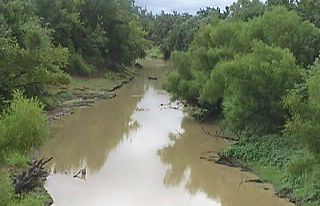
Fourche Maline is a 70.0-mile-long (112.7 km) tributary of the Poteau River in Oklahoma. The headwaters of Fourche Maline are in the Sans Bois Mountains in northwest Latimer County. It flows southwestward through Robbers Cave State Park, then southeastward past Wilburton before turning eastward until it reaches the Poteau River in Le Flore County. Fourche Maline's confluence with the Poteau River is now submerged in Lake Wister, about 6 miles (9.7 km) south of the confluence. The distance from origin to confluence is about 37 miles (60 km) Oklahoma Historian Muriel Wright translated the French name as meaning "treacherous fork" in English. During the days of the Indian Territory, Fourche Maline served as the boundary between Skullyville County and Sugar Loaf County, two of the constituent counties making up the Moshulatubbee District of the Choctaw Nation.
Lampsilis rafinesqueana, the Neosho mucket or Neosho pearly mussel, is a species of North American freshwater mussel endemic to Arkansas, Oklahoma, Illinois, Missouri and Kansas.

The Little River is a tributary of the Red River, with a total length of 217 miles (349 km), 130 miles (210 km) within the Choctaw Indian Reservation in southeastern Oklahoma and 87 miles (140 km) in southwestern Arkansas in the United States. Via the Red, it is part of the watershed of the Mississippi River. Six large reservoirs impound the Little River and its tributaries. The drainage basin of the river totals 4,204 square miles (10,890 km2), 2,204 square miles (5,710 km2) in Oklahoma and 2,036 square miles (5,270 km2) in Arkansas. The Little River and its upper tributaries are popular for recreational canoeing and kayaking.
Muddy Boggy Creek, also known as the Muddy Boggy River, is a 175-mile-long (282 km) river in south central Oklahoma. The stream headwaters arise just east of Ada in Pontotoc County. It is a major tributary of the Red River in south central Oklahoma. Clear Boggy Creek is a major tributary which enters the Muddy Boggy at a location known as River Mile 24 in Choctaw County. The river is inhabited by over one hundred species of fish.
Johns Valley is a geographic feature and place name located in the Kiamichi Mountains in northwestern Pushmataha County, Oklahoma. The valley] is formally classified by geologists as a “basin” due to its complete encirclement by mountains.
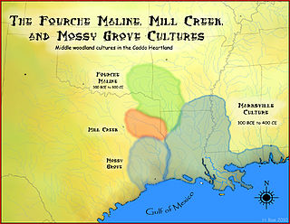
The Fourche Maline culture was a Woodland Period Native American culture that existed from 300 BCE to 800 CE, in what are now defined as southeastern Oklahoma, southwestern Arkansas, northwestern Louisiana, and northeastern Texas. They are considered to be one of the main ancestral groups of the Caddoan Mississippian culture, along with the contemporaneous Mill Creek culture of eastern Texas. This culture was named for the Fourche Maline Creek, a tributary of the Poteau River. Their modern descendants are the Caddo Nation of Oklahoma.