List of road routes in South Australia

Last updated

South Australia SA in Australia map.png
South Australia

Road routes in South Australia assist drivers navigating roads in urban, rural, and scenic areas of the state. Today, all numbered routes in the state are allocated a letter (M, A or B) in addition to a one, two or three digit number, denoting different levels of significance. The route system includes officially designated highways, urban freeways and arterial roads, and other important cross-state roads that have not been declared highways.

Contents

History

Route numbers have been allocated to South Australia's roads since 1955, with the introduction of National Routes across all states and territories in Australia, symbolised by a white shield with black writing; National Route 1 ('Highway 1') was one of the best-known numbered national routes, due to its fame for circumnavigating the continent.

In 1974, the National Highway network was defined, which allowed some existing National Routes to be upgraded to National Highways. These were marked with the same shield design as the National Routes, except for their gold-on-green colouring and the word NATIONAL added across the top. Unlike many other states, South Australia never adopted State Routes, although it allowed two Victorian rural State Routes to cross the border and terminate in locations within 20 km of it when they were rolled out there in 1985.

In 1998, the state replaced its system of National Routes and National Highways with an alphanumeric route numbering system. Many existing numbered routes were allocated a letter (M, A or B) in addition to its number, with 'M' routes denoting freeways, 'A' routes denoting routes of state significance, and 'B' routes denoting routes of local significance. Instead of shields, route numbers are displayed as yellow text on green rectangular backgrounds, and has now become the sole route numbering system in the state. The changeover to alphanumeric routes was carried out from 1998 either by removing old "shield" coverplates installed on newer signs, or installing new alphanumeric coverplates on old shielded signs, adopting the same design as Victoria (which adopted its alphanumeric system a year previous). Trailblazers were introduced with alphanumeric routes in Adelaide's metropolitan area and the tourist areas of Victor Harbor and the Barossa Valley in 1998, [1] [2] with allocations extended to cover country areas in 1999. [3] Former National Highways still retained their shield design (including NATIONAL markings) after conversion, but were modified in 2017 to remove them, bringing their design in line with the rest of the state.

Alphanumeric Routes

All alphanumeric routes listed here are derived from the Government of South Australia's Location SA service. [4]

M routes

Roads allocated an M route are usually at least dual-carriageway motorways or expressways, with at least two lanes in each direction. These roads keep traffic moving and are likely to have no traffic lights and higher speed limits. [5]

RouteComponent roadsFromViaToLengthNotes
AUS Alphanumeric Route M1.svg
M1
South Eastern Freeway Glen Osmond Murray Bridge 69 km (43 mi)Part of Highway 1:
– western end re-aligned through Eagle on the Hill from Mount Barker Road to current alignment when freeway extension through the Heysen Tunnels opened in 2000
– continues north west as AUS Alphanumeric Route A1.svg along Glen Osmond Road beyond Adelaide
– continues east as AUS Alphanumeric Route A1.svg along Princes Highway to Tailem Bend
– allocated Australian national highway M1.svg in 1998, progressively being replaced by AUS Alphanumeric Route M1.svg from 2017
AUS Alphanumeric Route M2.svg
M2
Northern Expressway Gawler Hindmarsh 51 km (32 mi)Allocated in 2016 (replacing Australian national highway M20.svg)
Northern Connector Allocated upon opening in 2020
North–South Motorway – allocated Australian national highway M2.svg through Wingfield (replacing Australian national highway A13.svg) when South Road Superway opened in 2014, progressively being replaced by AUS Alphanumeric Route M2.svg from 2017
– extended south to Hindmarsh (replacing AUS Alphanumeric Route A2.svg) when Torrens to Torrens section opened in 2018
– to be extended further south eventually to Southern Expressway as further stages of the North–South Motorway are completed
– continues south as AUS Alphanumeric Route A2.svg along South Road to Southern Expressway at St Marys
Southern Expressway St Marys Noarlunga Downs 21 km (13 mi)– southern end extended from Reynella to Noarlunga Downs when second stage opened in 2001
– northern end extended from Darlington to St Marys when Darlington bypass opened in 2020
– to be extended further north eventually to North–South Motorway as further stages are completed
– continues north as AUS Alphanumeric Route A2.svg along South Road to North–South Motorway at Hindmarsh
Australian national highway M20.svg
National Highway M20
Northern Expressway Virginia Gawler 22 km (14 mi)Allocated upon opening in 2010, replaced by AUS Alphanumeric Route M2.svg when Northern Connector commenced construction in 2016
  Decommissioned or unsigned route

A routes

Roads allocated an A route are main or arterial routes providing a high standard of driving conditions both across single- or dual-carriageway roads, linking to and from M roads and provide access to major towns and places of interest across metro and regional SA. [5]

RouteComponent roadsFromViaToLengthNotes
AUS Alphanumeric Route A1.svg
A1
SA/WA border Medindie 1,248 km (775 mi)Part of Highway 1:
– continues west as Australian national highway 1.svg along Eyre Highway into WA eventually to Norseman
– discontinuous across the Adelaide city centre, partially AUS Alphanumeric Route R1.svg
– allocated Australian national highway A1.svg in 1998, progressively being replaced by AUS Alphanumeric Route A1.svg from 2017
Eastwood Frewville Glen Osmond 3.3 km (2 mi)– discontinuous across the Adelaide city centre, partially AUS Alphanumeric Route R1.svg
– eastern end along Mount Barker Road terminating in Crafers truncated to current alignment when South Eastern Freeway extension through the Heysen Tunnels opened in 2000
– continues east as AUS Alphanumeric Route M1.svg along South Eastern Freeway to Murray Bridge
– allocated Australian national highway A1.svg in 1998, progressively being replaced by AUS Alphanumeric Route A1.svg from 2017
Princes Highway Murray Bridge Swanport Bridge Tailem Bend 22 km (14 mi)– continues west as AUS Alphanumeric Route M1.svg along South Eastern Freeway to Glen Osmond
– continues south as AUS Alphanumeric Route B1.svg along Princes Highway to Mount Gambier
– allocated Australian national highway A1.svg in 1998, progressively being replaced by AUS Alphanumeric Route A1.svg from 2017
Princes Highway Mount Gambier SA/Vic border18 km (11 mi)– continues west as AUS Alphanumeric Route B1.svg along Princes Highway to Tailem Bend
– continues east as AUS Alphanumeric Route A1.svg along Princes Highway into Victoria eventually to Geelong
AUS Alphanumeric Route A2.svg
A2
South Road Hindmarsh St Marys 11 km (7 mi)– allocated from Regency Park to Darlington (replacing AUS Alphanumeric Route A13.svg) when South Road Superway opened in 2014
– northern end truncated to Hindmarsh (replaced by AUS Alphanumeric Route M2.svg) when Torrens to Torrens section of North–South Motorway opened in 2018
– southern end truncated to St Marys (replaced by AUS Alphanumeric Route M2.svg) when Darlington bypass of Southern Expressway opened in 2020
– continues north as AUS Alphanumeric Route M2.svg along North–South Motorway to Gawler
– continues south as AUS Alphanumeric Route M2.svg along Southern Expressway to Noarlunga Downs
AUS Alphanumeric Route A3.svg
A3
Cross Road Plympton Unley Park Glen Osmond 9.5 km (6 mi)
AUS Alphanumeric Route A5.svg
A5
Anzac Highway Keswick Plympton Glenelg 13.8 km (9 mi)Northern end truncated from Adelaide to Keswick when AUS Alphanumeric Route R1.svg City Ring Route re-aligned in 2017
AUS Alphanumeric Route A6.svg
A6
Mile End Brooklyn Park West Beach 6.9 km (4 mi)Eastern end truncated from Adelaide to Mile End when AUS Alphanumeric Route R1.svg City Ring Route re-aligned in 2017
AUS Alphanumeric Route A7.svg
A7
Hindmarsh Port Adelaide 9.9 km (6 mi)
AUS Alphanumeric Route A8.svg
A8
Dukes Highway Tailem Bend SA/Vic border192 km (119 mi)– continues east as AUS Alphanumeric Route A8.svg along Western Highway into Victoria eventually to Beaufort
– concurrency with AUS Alphanumeric Route B57.svg along Dukes Highway from Lowan Vale to Bordertown
– allocated Australian national highway A8.svg in 1998, progressively being replaced by AUS Alphanumeric Route A8.svg from 2017
AUS Alphanumeric Route A9.svg
A9
Port Adelaide Elizabeth Vale 20.9 km (13 mi)Eastern end extended along Salisbury Highway and John Rice Avenue from Dry Creek to Elizabeth Vale (replacing Australian national highway A13.svg/AUS Alphanumeric Route A13.svg) when South Road Superway opened in 2014
AUS Alphanumeric Route A10.svg
A10
Gilberton Houghton 19.3 km (12 mi)Continues east as AUS Alphanumeric Route B10.svg along North East Road to Nurioopta
AUS Alphanumeric Route A11.svg
A11
Kent Town Salisbury Heights 25.1 km (16 mi)Northern end re-aligned from Lower North East Road terminating in Houghton (replaced by AUS Alphanumeric Route A16.svg) to current alignment in 2021
AUS Alphanumeric Route A13.svg
A13
Darlington Victor Harbor 67.6 km (42 mi)– allocation along South Road, Salisbury Highway and John Rice Avenue terminating in Elizabeth Vale truncated to current alignment (replaced by AUS Alphanumeric Route M2.svg/AUS Alphanumeric Route A2.svg and AUS Alphanumeric Route A9.svg) when South Road Superway opened in 2014
– concurrency with AUS Alphanumeric Route B34.svg along Victor Harbor Road through Willunga Hill
– allocated Australian national highway A13.svg along South Road through Wingfield in 1998, replaced by Australian national highway M2.svg in 2014, progressively being replaced by AUS Alphanumeric Route M2.svg from 2017
AUS Alphanumeric Route A14.svg
A14
Beverley Darlington 15.3 km (10 mi)
AUS Alphanumeric Route A15.svg
A15
Alberton Maslin Beach 45.3 km (28 mi)
  • Gray Street
  • Saltfleet Street
  • Commercial Road
  • Maslin Beach Road
Southern end extended from Hallett Cove to Maslin Beach in 2021
AUS Alphanumeric Route A16.svg
A16
Outer Harbor Houghton 37.5 km (23 mi)
Grand Junction Road Allocated Australian national highway A16.svg (from Regency Park to Northfield) in 1998, progressively being replaced by AUS Alphanumeric Route A16.svg from 2017
Lower North East Road Eastern end extended along Lower North East Road from Hope Valley to Houghton (replacing AUS Alphanumeric Route A11.svg) in 2021
AUS Alphanumeric Route A17.svg
A17
Northfield Payneham Glen Osmond 13.7 km (9 mi)Allocated Australian national highway A17.svg in 1998, progressively being replaced by AUS Alphanumeric Route A17.svg from 2017
AUS Alphanumeric Route A18.svg
A18
Paralowie Parafield Modbury 12.5 km (8 mi)
AUS Alphanumeric Route A20.svg
A20
Gepps Cross SA/Vic border267 km (166 mi)– continues east as AUS Alphanumeric Route A20.svg along Sturt Highway into Victoria through Mildura, and into New South Wales eventually to Tarcutta
– allocated Australian national highway A20.svg in 1998, progressively being replaced by AUS Alphanumeric Route A20.svg from 2017
– western end along Main North Road terminating at Gepps Cross truncated to Gawler (replaced by AUS Alphanumeric Route A52.svg) when Northern Expressway opened in 2010, reverted to AUS Alphanumeric Route A20.svg in 2017
AUS Alphanumeric Route A21.svg
A21
Adelaide North Adelaide Adelaide 15.6 km (10 mi)Former City Ring Route, replaced by AUS Alphanumeric Route R1.svg in 2017, listed clockwise from the western corner of Adelaide city centre
AUS Alphanumeric Route A22.svg
A22
Gepps Cross Kilburn Ovingham 7.7 km (5 mi)
AUS Alphanumeric Route A32.svg
A32
Barrier Highway Giles Corner SA/NSW border377 km (234 mi)– continues east as AUS Alphanumeric Route A32.svg along Barrier Highway into New South Wales to Nyngan
– concurrency with AUS Alphanumeric Route B64.svg along Barrier Highway through Burra
AUS Alphanumeric Route A52.svg
A52
Main North Road Gepps Cross Gawler 32 km (20 mi)Allocated when Northern Expressway opened (replacing Australian national highway A20.svg) in 2010, reverted to AUS Alphanumeric Route A20.svg in 2017
AUS Alphanumeric Route A66.svg
A66
Riddoch Highway Keith Mount Gambier 210 km (130 mi)Continues south as AUS Alphanumeric Route B66.svg along Riddoch Highway to Port MacDonnell
AUS Alphanumeric Route A87.svg
A87
Stuart Highway SA/NT border Port Augusta West 928 km (577 mi)– continues north as AUS Alphanumeric Route A87.svg along Stuart Highway into NT eventually to Daly Waters
– allocated Australian national highway A87.svg in 1998, progressively being replaced by AUS Alphanumeric Route A87.svg from 2017
  Decommissioned or unsigned route

B routes

Roads allocated a B route are secondary or local arterial roads, These roads link to and from A and M roads and provide access to places of interest across metro and regional SA. [5]

RouteComponent roadsFromViaToLengthNotes
AUS Alphanumeric Route B1.svg
B1
Princes Highway Tailem Bend Mount Gambier 350 km (217 mi)Part of Highway 1:
– continues north as AUS Alphanumeric Route A1.svg along Princes Highway to Murray Bridge
– continues east as AUS Alphanumeric Route A1.svg along Princes Highway into Victoria eventually to Geelong
AUS Alphanumeric Route B10.svg
B10
Houghton Nurioopta 73 km (45 mi)– continues west as AUS Alphanumeric Route A10.svg along North East Road to Adelaide
– concurrencies with: AUS Alphanumeric Route B31.svg along North East Road through Chain of Ponds; AUS Alphanumeric Route B34.svg along Torrens Valley Road through Birdwood; AUS Alphanumeric Route B35.svg along Torrens Valley Road through Mount Pleasant
AUS Alphanumeric Route B12.svg
B12
Mallee Highway Tailem Bend SA/Vic border145 km (90 mi)– continues east as AUS Alphanumeric Route B12.svg along Mallee Highway into Victoria eventually to Piangil
– concurrency with AUS Alphanumeric Route B57.svg along Mallee Highway through Pinnaroo
AUS Alphanumeric Route B19.svg
B19
Gawler Lyndoch Nuriootpa 39 km (24 mi)
AUS Alphanumeric Route B23.svg
B23
Main South Road Old Noarlunga Cape Jervis 75 km (47 mi)Route continues west over Backstairs Passage to Hog Bay Road on Kangaroo Island
Penneshaw Pelican Lagoon Kingscote 60 km (37 mi)Route continues east over Backstairs Passage to Main South Road on the South Australian mainland
AUS Alphanumeric Route B26.svg
B26
Greenhill Road Glenside Uraidla Balhannah 24 km (15 mi)Allocated in 2019
AUS Alphanumeric Route B27.svg
B27
  • Magill Road
  • Old Norton Summit Road
  • Lobethal Road
  • Mount Torrens Road
Kent Town Mount Torrens 37 km (23 mi)Allocated in 2019
AUS Alphanumeric Route B28.svg
B28
  • Fullarton Road
  • Old Belair Road
  • Upper Sturt Road
  • Waverley Ridge Road
  • Mount Lofty Summit Road
Fullarton Summertown 25 km (16 mi)Allocated in 2019
AUS Alphanumeric Route B29.svg
B29
Unley Clarendon 27 km (17 mi)Allocated in 2020
AUS Alphanumeric Route B31.svg
B31
Campbelltown Lyndoch 49 km (30 mi)Concurrency with AUS Alphanumeric Route B10.svg along North East Road through Chain of Ponds
AUS Alphanumeric Route B33.svg
B33
Stirling Strathalbyn 37 km (23 mi)
AUS Alphanumeric Route B34.svg
B34
Williamstown Myponga 109 km (68 mi)Concurrencies with: AUS Alphanumeric Route A13.svg along Victor Harbor Road through Willunga Hill; AUS Alphanumeric Route B10.svg along Torrens Valley Road through Birdwood
AUS Alphanumeric Route B35.svg
B35
  • Cricks Mill Road
  • Tungkillo Road
  • Randell Road
  • Reedy Creek Road
  • Mannum Road
  • Swanport Road
Mount Crawford Murray Bridge 63 km (39 mi)Concurrency with AUS Alphanumeric Route B10.svg along Torrens Valley Road through Mount Pleasant
AUS Alphanumeric Route B36.svg
B36
Palmer Mannum Murray Bridge North 38 km (24 mi)
AUS Alphanumeric Route B37.svg
B37
Mount Barker Delamere 126 km (78 mi)Concurrency with AUS Alphanumeric Route A13.svg along Hindmarsh Road through Victor Harbor
AUS Alphanumeric Route B45.svg
B45
  • Langhorne Creek Road
  • Ferry Road
Strathalbyn Langhorne Creek Wellington East 49 km (30 mi)
AUS Alphanumeric Route B55.svg
B55
Murray Bridge Berri 202 km (126 mi)
AUS Alphanumeric Route B56.svg
B56
Winninowie Peterborough 108 km (67 mi)Concurrencies with: AUS Alphanumeric Route B80.svg along RM Williams Way from Orroroo to Black Rock; AUS Alphanumeric Route B82.svg along Horrocks Highway through Wilmington
AUS Alphanumeric Route B57.svg
B57
Loxton Cadgee 292 km (181 mi)Concurrencies with: AUS Alphanumeric Route A8.svg along Dukes Highway from Lowan Vale to Bordertown; AUS Alphanumeric Route B12.svg along Mallee Highway through Pinnaroo
AUS Alphanumeric Route B64.svg
B64
Goyder Highway Crystal Brook Monash 266 km (165 mi)Concurrencies with: AUS Alphanumeric Route A32.svg along Barrier Highway through Burra; AUS Alphanumeric Route B80.svg along RM Williams Way through Spalding; AUS Alphanumeric Route B82.svg along Horrocks Highway through Gulnare
AUS Alphanumeric Route B66.svg
B66
Riddoch Highway Mount Gambier Mount Schank Port MacDonnell 28 km (17 mi)Continues north as AUS Alphanumeric Route A66.svg along Riddoch Highway to Mount Gambier
AUS Alphanumeric Route B77.svg
B77
  • Mallala Road
  • Old Port Wakefield Road
  • Gawler Road
  • Two Wells Road
  • Ryde Street
  • Overway Bridge Road
  • Fifteenth Street
  • Twelfth Street
Two Wells Gawler River Gawler 23.5 km (15 mi)Allocated in 2021
AUS Alphanumeric Route B78.svg
B78
Wilkins Highway Jamestown Hallett 38 km (24 mi)
AUS Alphanumeric Route B79.svg
B79
Warnertown Ucolta 104 km (65 mi)Concurrency with AUS Alphanumeric Route B80.svg along RM Williams Way from Mannanarie to Jamestown
AUS Alphanumeric Route B80.svg
B80
RM Williams Way Hawker Barinia 220 km (137 mi)Concurrencies with: AUS Alphanumeric Route B56.svg along RM Williams Way from Orroroo to Black Rock; AUS Alphanumeric Route B64.svg along Goyder Highway through Spalding; AUS Alphanumeric Route B79.svg along RM Williams Way from Mannanarie to Jamestown
AUS Alphanumeric Route B81.svg
B81
Thiele Highway Gawler Belt Morgan 115 km (71 mi)
AUS Alphanumeric Route B82.svg
B82
Quorn Gawler Belt 282 km (175 mi)Concurrencies with: AUS Alphanumeric Route B56.svg along Wilmington–Ucolta Road through Wilmington; AUS Alphanumeric Route B64.svg along Goyder Highway through Gulnare
AUS Alphanumeric Route B83.svg
B83
Lyndhurst Stirling North 292 km (181 mi)Much of this route still is signed Australian national route 83.svg; Australian national route 47.svg shields still visible at Flinders Ranges Way and West Terrace intersection in Quorn
AUS Alphanumeric Route B84.svg
B84
  • Port Wakefield–Balaklava Road
  • Saddleworth Road
  • Marrabel Road
  • Curio Road
Port Wakefield Eudunda 100 km (62 mi)
AUS Alphanumeric Route B85.svg
B85
Copper Coast Highway Port Wakefield Wallaroo 58 km (36 mi)
AUS Alphanumeric Route B86.svg
B86
Yorke Highway Port Arthur Stenhouse Bay 181 km (112 mi)
AUS Alphanumeric Route B88.svg
B88
St Vincent Highway Pine Point Warooka 101 km (63 mi)
AUS Alphanumeric Route B89.svg
B89
Spencer Highway Port Pirie Minlaton 199 km (124 mi)
AUS Alphanumeric Route B90.svg
B90
Tod Highway Kyancutta Uley 176 km (109 mi)
AUS Alphanumeric Route B91.svg
B91
Birdseye Highway Elliston Cowell 198 km (123 mi)
AUS Alphanumeric Route B97.svg
B97
  • Pimba Road
  • Olympic Dam Highway
Pimba Olympic Dam 89 km (55 mi)
AUS Alphanumeric Route B100.svg
B100
Ceduna Lincoln Gap 715 km (444 mi)
AUS Alphanumeric Route B101.svg
B101
Southern Ports Highway Kingston SE Millicent 119 km (74 mi)
AUS Alphanumeric Route B160.svg
B160
Glenelg Highway Glenburnie SA/Vic border15.3 km (10 mi)Continues east as AUS Alphanumeric Route B160.svg along Glenelg Highway into Victoria eventually to Ballarat (a Victorian B route "extended" into SA)
AUS Alphanumeric Route B201.svg
B201
  • Old Sturt Highway
  • Berri–Renmark Road
Barmera Berri Monash 16.8 km (10 mi)Former AUS Alphanumeric Route A20.svg Sturt Highway alignment

C routes

Roads allocated a C route are major collector roads, linking local roads and streets to the arterial road network for inter-state travel. [5]

While officially gazetted C routes exist in South Australia, these are currently based on existing Victorian C routes terminating in South Australian locations just inside the SA/Vic state border, and do not exist anywhere else in the state.

RouteComponent roadsFromViaToLengthNotes
AUS Alphanumeric Route C192.svg
C192
Glenelg River Road Mount Gambier Wye SA/Vic border30 km (19 mi)Continues east as AUS Alphanumeric Route C192.svg along Glenelg River Road into Victoria to Portland
AUS Alphanumeric Route C198.svg
C198
Casterton Road Penola SA/Vic border17.4 km (11 mi)Continues east as AUS Alphanumeric Route C198.svg along Casterton–Penola Road into Victoria to Casterton
AUS Alphanumeric Route C212.svg
C212
Edenhope Road Wrattonbully SA/Vic border13.3 km (8 mi)Continues east as AUS Alphanumeric Route C212.svg along Edenhope–Penola Road into Victoria to Edenhope
AUS Alphanumeric Route C240.svg
C240
Wimmera Highway Naracoorte SA/Vicborder23 km (14 mi)Continues east as AUS Alphanumeric Route B240.svg along Wimmera Highway into Victoria to Marong

R routes

Roads allocated a R route are for ring roads, provide a path around a city, rather than travelling through it. [5]

South Australia is currently the only state in the country to use R routes. To date, there is only one R route: around Adelaide, the state's capital city.

RouteComponent roadsFromViaToLengthNotes
AUS Alphanumeric Route R1.svg
R1
City Ring Route
Adelaide North Adelaide Adelaide 16.9 km (11 mi)Replaced AUS Alphanumeric Route A21.svg in 2017 on a slightly different alignment to the southwest, listed clockwise from the western corner of Adelaide city centre

Former Routes

National Routes

National Routes were the first type of route numbering to be attempted in Australia on a large scale, signed with a white shield and black writing (similar in shape to the shield that appears on the Australian coat of arms), with South Australia receiving routes in 1955. They highlighted the interstate links connecting major population, industrial and principal regions of New South Wales to the rest of the Australia, in a way that was readily identifiable to interstate travellers. The system was prepared by the Conference of State Road Authorities, held between 1953 and 1954: once each state road authority agreed to the scheme, it was rolled out federally.

Selected routes were later upgraded into National Highways when the National Roads Act was passed in 1974.

South Australia's National Routes were eventually replaced with the alphanumeric system, introduced across the state between 1998 and 1999: each route was converted to an alphanumeric route number, rendering the black-and-white shield redundant. Most National Routes in rural South Australia kept their number during the conversion; two exceptions were National Route 47 (which became B83), and National Route 83 (which became B80, B82 and B83).

RouteComponent roadsFromViaToLengthNotes
Australian national route 1.svg
National Route 1
SA/WA borderSA/Vic border1,716 km (1,066 mi)– progressively reallocated along South Eastern Freeway sections as they opened
– replaced by Australian national highway 1.svg from SA/WA border to Tailem Bend in 1974
Princes Highway (II)Replaced by: AUS Alphanumeric Route A1.svg from Mount Gambier to SA/Vic border; AUS Alphanumeric Route B1.svg from Tailem Bend to Mount Gambier in 1998
Australian national route ALT1.svg
Alternate
National Route 1
Ceduna Lincoln Gap 715 km (444 mi)Allocated after road sealing and upgrades of Flinders Highway completed in 1978, replaced by AUS Alphanumeric Route B100.svg in 1999
Southern Ports Highway Kingston SE Millicent 119 km (74 mi)– former Princes Highway alignment (bypassed in 1933)
– allocated in 1978, replaced by AUS Alphanumeric Route B101.svg in 1999
  • Adelaide Road
  • Old Princes Highway
White Hill Murray Bridge Long Flat 13.2 km (8 mi)Allocated when Swanport Bridge over the Murray River opened in 1979, replaced by AUS Alphanumeric Route B55.svg from White Hill to Murray Bridge East in 1998
Australian national route 8.svg
National Route 8
Dukes Highway Tailem Bend SA/Vic border192 km (119 mi)Replaced by Australian national highway 8.svg in 1974
Australian national route 12.svg
National Route 12
Mallee Highway Tailem Bend SA/Vic border145 km (90 mi)Replaced by AUS Alphanumeric Route B12.svg in 1998
Australian national route 20.svg
National Route 20
Gepps Cross SA/Vic border267 km (166 mi)Replaced by Australian national highway 20.svg in 1992
Australian national route ALT20.svg
Alternative
National Route 20
Old Sturt Highway Barmera Berri Monash 16.8 km (10 mi)Former Australian national highway 20.svg Sturt Highway alignment, replaced by AUS Alphanumeric Route B201.svg in 1999
Australian national route 32.svg
National Route 32
Gawler SA/NSW border417 km (259 mi)Replaced by AUS Alphanumeric Route A32.svg in 1998
Australian national route 47.svg
National Route 47
Flinders Ranges Way Hawker Quorn Stirling North 98 km (61 mi)Replaced by AUS Alphanumeric Route B83.svg in 1998
Australian national route 56.svg
National Route 56
Wilmington–Ucolta Road Winninowie Ucolta 123 km (76 mi)Replaced by AUS Alphanumeric Route B56.svg in 1998
Australian national route 64.svg
National Route 64
Goyder Highway Crystal Brook Monash 266 km (165 mi)Replaced by AUS Alphanumeric Route B64.svg in 1998
Australian national route 83.svg
National Route 83
The Outback Highway (Barndioota Road) Lyndhurst Giles Corner 292 km (181 mi)Replaced by AUS Alphanumeric Route B83.svg in 1998
RM Williams Way Replaced by AUS Alphanumeric Route B80.svg in 1998
Main North Road Replaced by AUS Alphanumeric Route B82.svg in 1998
Australian national route 87.svg
National Route 87
Stuart Highway SA/NT border Port Augusta West 928 km (577 mi)Replaced by Australian national highway 87.svg in 1974
  Decommissioned or unsigned allocation

National Highways

With the passing of the National Roads Act in 1974, selected National Routes were further upgraded to the status of a National Highway: interstate roads linking Australia's capital cities and major regional centres that received federal funding, and were of higher importance than other National Routes. These new routes were symbolised by green shields with gold writing, and the word "National" along the top of the shield. Most of South Australia's National Highways were declared in 1974 and their shields converted in the following years, with National Highway 20 later declared in 1992.

Like National Routes, South Australia's National Highways were also replaced with the alphanumeric system, introduced across the state in 1998: each route was converted to an alphanumeric route number, all keeping their number during the conversion, but also initially keeping the National green-and-gold shield design; this was eventually eliminated in 2017.

RouteComponent roadsFromViaToLengthNotes
Australian national highway 1.svg
National Highway 1
SA/WA border Tailem Bend 1,716 km (1,066 mi)– replaced by Australian national highway A1.svg in 1998, being progressively replaced by AUS Alphanumeric Route A1.svg from 2017
Princes Highway (I) renamed Augusta Highway in 2011
South Eastern Freeway – progressively reallocated along South Eastern Freeway sections as they opened eventually to Murray Bridge in 1979
– replaced by Australian national highway M1.svg in 1998, being progressively replaced by AUS Alphanumeric Route M1.svg from 2017
Princes Highway (II)Replaced by Australian national highway A1.svg in 1998, being progressively replaced by AUS Alphanumeric Route A1.svg from 2017
Australian national highway 8.svg
National Highway 8
Dukes Highway Tailem Bend SA/Vic border192 km (119 mi)– western end re-aligned from Tailem Bend to Coomandook through Cooke Plains in 1980
– re-aligned through Bordertown when Bordertown bypass opened in 1987
– replaced by Australian national highway A8.svg in 1998, being progressively replaced by AUS Alphanumeric Route A8.svg from 2017
Australian national highway 20.svg
National Highway 20
Gepps Cross SA/Vic border267 km (166 mi)Replaced by Australian national highway A20.svg in 1998, being progressively replaced by AUS Alphanumeric Route A20.svg from 2017
Australian national highway 87.svg
National Highway 87
Stuart Highway SA/NT border Port Augusta West 928 km (577 mi)Replaced by Australian national highway A87.svg in 1998, being progressively replaced by AUS Alphanumeric Route A87.svg from 2017
  Decommissioned or unsigned allocation

State Routes (from Victoria)

South Australia never adopted State Routes, but allowed two Victorian rural State Routes to cross the border and terminate in South Australian locations within 20 km of it when they were rolled out there in 1985; these were replaced by their Victorian equivalent alphanumeric allocations in 1998.

RouteComponent roadsFromViaToLengthNotes
Australian state route 112.svg
State Route 112
Glenelg Highway Glenburnie SA/Vic border15.3 km (10 mi)Continued east as Australian state route 112.svg along Glenelg Highway into Victoria eventually to Ballarat; replaced by AUS Alphanumeric Route B160.svg in 1998
Australian state route 130.svg
State Route 130
Wimmera Highway Naracoorte SA/Vic border23 km (14 mi)Continued east as Australian state route 130.svg along Wimmera Highway into Victoria eventually to St Arnaud; replaced by AUS Alphanumeric Route C240.svg in 1998
  Decommissioned or unsigned route

See also

Related Research Articles

<span class="mw-page-title-main">Highways in Australia</span>

Highways in Australia are generally high capacity roads managed by state and territory government agencies, though Australia's federal government contributes funding for important links between capital cities and major regional centres. Prior to European settlement, the earliest needs for trade and travel were met by narrow bush tracks, used by tribes of Indigenous Australians. The formal construction of roads began in 1788, after the founding of the colony of New South Wales, and a network of three major roads across the colony emerged by the 1820s. Similar road networks were established in the other colonies of Australia. Road construction programs in the early 19th century were generally underfunded, as they were dependent on government budgets, loans, and tolls; while there was a huge increase in road usage, due to the Australian gold rushes. Local government authorities, often known as Road Boards, were therefore established to be primarily responsible for funding and undertaking road construction and maintenance. The early 1900s saw both the increasingly widespread use of motorised transportation, and the creation of state road authorities in each state, between 1913 and 1926. These authorities managed each state's road network, with the main arterial roads controlled and maintained by the state, and other roads remaining the responsibility of local governments. The federal government became involved in road funding in the 1920s, distributing funding to the states. The depression of the 1930s slowed the funding and development of the major road network until the onset on World War II. Supply roads leading to the north of the country were considered vital, resulting in the construction of Barkly, Stuart, and Eyre Highways.

<span class="mw-page-title-main">Sturt Highway</span> Australian national highway

Sturt Highway is an Australian national highway in New South Wales, Victoria, and South Australia. It is an important road link for the transport of passengers and freight between Sydney and Adelaide and the regions along the route.

<span class="mw-page-title-main">Barrier Highway</span> Highway in New South Wales and South Australia

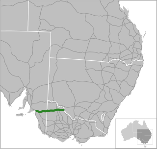
Barrier Highway is a highway in South Australia and New South Wales, and is designated part of route A32. The name of the highway is derived from the Barrier Ranges, an area of moderately high ground in the far west of New South Wales, through which the highway traverses.

A routenumber, designation or abbreviation is an identifying numeric designation assigned by a highway authority to a particular stretch of roadway to distinguish it from other routes and, in many cases, also to indicate its classification, general geographical location and/or orientation. The numbers chosen may be used solely for internal administrative purposes; however, in most cases they are also displayed on roadside signage and indicated on maps.

<span class="mw-page-title-main">Mallee Highway</span>

Mallee Highway is a highway in south-eastern South Australia and north-western Victoria, running mostly across the Mallee plains. It forms part of the shortest route between Adelaide and Sydney.

<span class="mw-page-title-main">Murray Valley Highway</span> Highway in Victoria and New South Wales

Murray Valley Highway is a 663-kilometre (412 mi) state highway located in Victoria and New South Wales, Australia. The popular tourist route mostly follows the southern bank of the Murray River and effectively acts as the northernmost highway in Victoria. For all but the western end's last three kilometres, the highway is allocated route B400.

Moorooduc Highway is a 16 km highway which runs from Frankston to Tuerong and, together with the Mornington Peninsula Freeway, was part of the main route from Melbourne to the Mornington Peninsula until the completion of Peninsula Link in 2013. This name is not widely known to most drivers, as the entire allocation is still best known as by the names of its constituent parts: McMahons Road, Frankston–Flinders Road, and Moorooduc Road.

<span class="mw-page-title-main">Main North Road</span> Road in South Australia

Main North Road is the major north–south arterial route through the suburbs north of the Adelaide City Centre in the city of Adelaide, South Australia, and linking to Gawler on Adelaide's outer north-eastern fringes.

Glenelg Highway is a rural highway in south-eastern Australia, linking Mount Gambier with Ballarat. Most of the highway is located within the Western part of the state of Victoria, though a short, 15 km stretch from the South Australia/Victoria state border near Ardno to Glenburnie is located in South Australia. Some maps identify the South Australian stretch as Casterton Road. Major towns along its route include Casterton, Coleraine and Hamilton.

<span class="mw-page-title-main">Wimmera Highway</span> Highway in Victoria and South Australia

Wimmera Highway is a 345 kilometre highway that connects the towns of Marong, Victoria and Naracoorte, South Australia, through the major junctions of Sunraysia Highway, Henty Highway and Western Highway.

<span class="mw-page-title-main">M80 Ring Road</span> Freeway in Melbourne, Australia

The M80 Ring Road is a partially complete urban freeway ring road around Melbourne, Australia. This article will deal with the entire length of the corridor for sake of completion, as well to avoid confusion between declarations.

Camden Valley Way is a 23-kilometre (14 mi) arterial road between the southwestern fringes of suburban Sydney and the historic town of Camden. It is a former alignment of Hume Highway.

References

  1. "Metropolitan Publications". Department for Transport, Urban Planning and the Arts, Metropolitan Region. Archived from the original on 21 April 2000. Trailblazers is a new route numbering system that guides both local and visiting road users through unfamiliar areas by the most efficient routes. This brochure includes a map illustrating the 19 designated routes in the metropolitan area extending to main tourism locations of Victor Harbor and the Barossa Valley. The new signs display the route number, the name of the road being travelled on, major crossroads being approached and destinations along each leg.
  2. "Where the new routes are". Department for Transport, Urban Planning and the Arts, Transport SA, Metropolitan Region. Archived from the original on 10 September 2002.
  3. The Hon. Diana Laidlaw (24 June 1999). "Address to Estimates Committee B" (PDF). Hansard. House of Assembly - Estimates Committee B. Parliament of South Australia: 102. Archived from the original (PDF) on 14 July 2014. Retrieved 12 September 2012. In terms of each class of output to be delivered by Transport SA in the year 1999-2000, the highlights are as follows: ... extension of the route numbering system across the rural arterial network ...
  4. "Location SA Map viewer with road route layers". Government of South Australia . Retrieved 26 June 2022.
  5. 1 2 3 4 5 "A simpler way to navigate". Government of South Australia, Department for Infrastructure and Transport. Government of South Australia. 25 March 2020. Retrieved 26 June 2022.