The American Discovery Trail is a system of recreational trails and roads which collectively form a coast-to-coast hiking and biking trail across the mid-tier of the United States. Horses can also be ridden on most of this trail. The coastal trailheads are the Delmarva Peninsula on the Atlantic Ocean and the northern California coast on the Pacific Ocean. The trail has northern and southern alternates for part of its distance, passing through Chicago and St. Louis respectively. The total length of the trail including both the north and south routes is 6,800 miles (10,944 km). The northern route covers 4,834 miles (7,780 km) with the southern route covering 5,057 miles (8,138 km). It is the only non-motorized coast-to-coast trail.

Kisatchie National Forest, the only National forest in Louisiana, United States, is located in the forested piney hills and hardwood bottoms of seven central and northern parishes. It is part of the Cenozoic uplands and has large areas of longleaf pine forests. It is one of the largest pieces of natural landscape in Louisiana, with some 604,000 acres (2,440 km2) of public land, more than half of which is vital longleaf pine and flatwoods vegetation. These support many rare plant and animal species. There are also rare habitats, such as hillside seepage bogs and calcareous prairies. The forest also contains and provides a buffer for the Kisatchie Hills Wilderness, a nationally designated wilderness area that contributes to protecting biodiversity of the coastal plain region of the United States.

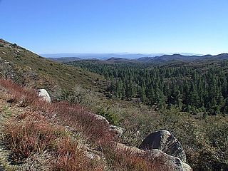
Cleveland National Forest encompasses 460,000 acres, mostly of chaparral, with a few riparian areas. A warm dry mediterranean climate prevails over the forest. It is the southernmost U.S. National Forest of California. It is administered by the U.S. Forest Service, a government agency within the United States Department of Agriculture. It is divided into the Descanso, Palomar and Trabuco Ranger Districts and is located in the counties of San Diego, Riverside, and Orange.
The Spring Mountains National Recreation Area (SMNRA) is a U.S. national recreation area, administered by the U.S. Forest Service, west of Las Vegas, Nevada. It covers over 316,000 acres. The area runs from low meadows, to the 11,918-foot (3,633 m) Mount Charleston. The SMNRA is a part of the Humboldt-Toiyabe National Forest. It adjoins the Red Rock Canyon National Conservation Area, which is administered by the Bureau of Land Management.

Chippewa National Forest is a National Forest located in north central Minnesota, United States, in the counties of Itasca, Cass and Beltrami. Forest headquarters are located in Cass Lake, Minnesota. There are local ranger district offices in Blackduck, Deer River and Walker.

Lincoln National Forest is a unit of the U.S. Forest Service located in southern New Mexico. Established by Presidential Proclamation in 1902 as the Lincoln Forest Reserve, the 1,103,897 acres (4,467.31 km2) forest begins near the Texas border and contains lands in parts of Chaves, Eddy, Lincoln, and Otero counties. The three Ranger Districts within the forest contain all or part of four mountain ranges, and include a variety of different environmental areas, from desert to heavily forested mountains and sub-alpine grasslands. Established to balance conservation, resource management, and recreation, the lands of the Lincoln National Forest include important local timber resources, protected wilderness areas, and popular recreation and winter sports areas. The forest headquarters is located in Alamogordo, N.M. with local offices in Carlsbad, Cloudcroft, and Ruidoso.

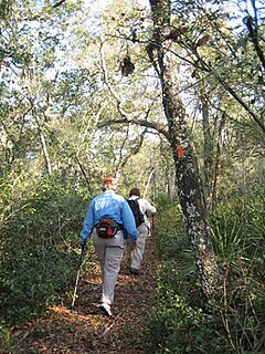
The Florida Trail is one of eleven National Scenic Trails in the United States. It currently runs 1,000 miles (1,600 km), with 300 miles (480 km) planned, from Big Cypress National Preserve to Fort Pickens at Gulf Islands National Seashore, Pensacola Beach. Also known as the Florida National Scenic Trail, the Florida Trail provides permanent non-motorized recreation opportunity for hiking and other compatible activities and is within an hour of most Floridians. The Florida National Scenic Trail is designated as a National Scenic Trail by the National Trails System Act of 1968.

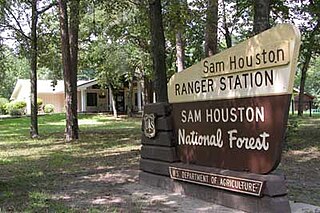
The Sam Houston National Forest, one of four National Forests in Texas, is located 50 miles north of Houston. The forest is administered together with the other three United States National Forests and two National Grasslands located entirely in Texas, from common offices in Lufkin, Texas. The units include Angelina, Davy Crockett, Sabine, and Sam Houston National Forests, plus Caddo National Grassland and Lyndon B. Johnson National Grassland. There are local ranger district offices located in New Waverly. It is located in portions of three Texas counties including Montgomery, San Jacinto, and Walker.

Ouachita National Recreation Trail is a 223-mile (359 km) long, continuous hiking trail through the Ouachita Mountains of Oklahoma and Arkansas. It is the longest backpacking trail in the Ouachita National Forest, spanning 192 miles across its length. Approximately 177 miles of the trail is in Arkansas and 46 miles of the trail is in Oklahoma. The trail is used by hikers, backpackers, hunters, and mountain bikers. It is a non-motorized single track trail open only to foot traffic and partially open to mountain bicycles. Segments opened to mountain bikes are from the western terminus of the Ouachita Trail at Talimena State Park to the Big Cedar trailhead on US Highway 259 at approximately Mile Marker (MM) 30.5 in Oklahoma, and from the Talimena Scenic Drive Trailhead at MM 54.1, east to Highway 7 at mile 160.4, north of Jessieville, Arkansas.

Hells Canyon National Recreation Area is a United States national recreation area on the borders of the U.S. states of Oregon and Idaho. Managed by the U.S. Forest Service as part of the Wallowa-Whitman National Forest, the recreation area was established by Congress and signed by President Gerald Ford in late 1975 to protect the historic and archaeological values of the Hells Canyon area and the area of the Snake River between Hells Canyon Dam and the Oregon–Washington border.

The Salmon River is a 33.5-mile (53.9 km) river in the Cascade Range in the U.S. state of Oregon that drains part of southwestern Mount Hood. The entire length of the river is a protected National Wild and Scenic River. Several portions are in protected wilderness. It is affluent to the Sandy River, a tributary of the Columbia River.

The Uinta Highline Trail is a trail in the Uinta Mountains of Utah that traverses the range 104 miles (167 km) from east to west. The trail passes through expansive alpine landscapes dominated by metasedimentary rocks sculpted by past glaciers. The broad glacial basins are dotted by hundreds of lakes.

Eagle Cap Wilderness is a wilderness area located in the Wallowa Mountains of northeastern Oregon, within the Wallowa–Whitman National Forest. The wilderness was established in 1940. In 1964, it was included in the National Wilderness Preservation System. A boundary revision in 1972 added 73,000 acres (30,000 ha) and the Wilderness Act of 1964 added 66,100 acres (26,700 ha) resulting in a current total of 361,446 acres, making Eagle Cap by far Oregon's largest wilderness area.

Millcreek Canyon is a canyon in the Wasatch Mountains and part of Millcreek City on the east side of the Salt Lake Valley, Utah. It is a popular recreation area both in the summer and in the winter. It was named by Brigham Young on August 22, 1847 before all of the mills that were built in and below the densely forested canyon. It is home to two restaurants and six Boy Scout Day Camps.

The Yolla Bolly–Middle Eel Wilderness is a federally designated wilderness area in the Yolla Bolly Range of the southern Klamath Mountains and the Inner Northern California Coast Ranges, in Northern California.

Sawtooth Lake is an alpine lake in Custer County, Idaho, United States, located high in the Sawtooth Mountains in the Sawtooth National Recreation Area. The lake is approximately 6.8 miles (10.9 km) southwest of Stanley. A trail from the Iron Creek trailhead and campground leads approximately 5 miles to Sawtooth Lake. The Iron Creek trailhead can be accessed from State Highway 21 via Sawtooth National Forest road 619.

The White Mountain Wilderness is a 46,963 acre designated wilderness area managed by the United States Forest Service. Located in the Smokey Bear Ranger District of the Lincoln National Forest, the White Mountain Wilderness lies in the Sierra Blanca mountains of south central New Mexico, approximately 15 miles (24 km) north northwest of the town of Ruidoso.
Womble Trail, located in the Ouachita National Forest in western Arkansas, United States, is a singletrack path running more than 37 miles from North Fork Lake to the Ouachita National Recreation Trail. The U.S. Forest Service trail is open for use by mountain bikers and hikers. Horses are not allowed. The nearest towns are Mount Ida and Oden.

The Uwharrie Trail is a hiking trail located in the Uwharrie Mountains in central North Carolina. The original Uwharrie Trail was an approximately 40-mile (80.5-km) long hiking trail that was completed in 1975. The trail began at the Asheboro Regional airport near Tot Hill Farm road and ended at NC 24-27 in Montgomery County near Troy, NC. It was once fragmented south of the Birkhead Wilderness to Jumpin Off Rock Trailhead on Flint Hill Rd.


