Angelo Bruno was a Sicilian-American mobster, notable for being boss of the Philadelphia crime family for two decades until his assassination. Bruno was known as "the Gentle Don" due to his preference for conciliation over violence, in stark contrast to his successors.
Frankford is a neighborhood in the Northeast section of Philadelphia situated about six miles (10 km) northeast of Center City. Although its borders are vaguely defined, the neighborhood is bounded roughly by the original course of Frankford Creek on the south to Castor Avenue on the northwest and southwest, to Cheltenham Avenue on the north, and to Aramingo Avenue and I-95 on the east. [source: GoogleMaps] Adjacent neighborhoods are Bridesburg, Juniata, Northwood, Summerdale, and Wissinoming.

South Philadelphia, nicknamed South Philly, is the section of Philadelphia bounded by South Street to the north, the Delaware River to the east and south, and the Schuylkill River to the west. A diverse working-class community of many neighborhoods, South Philadelphia is well-known for its large Italian-American population, but it also contains large Asian American, Irish-American, African-American, and Latino populations.

Wynnewood is a suburban unincorporated community, located west of Philadelphia, straddling Lower Merion Township in Montgomery County, Pennsylvania and Haverford Township in Delaware County, Pennsylvania, United States.

East Falls is a neighborhood in Lower Northwest, Philadelphia, Pennsylvania, United States. It lies on the east bank of the "Falls of the Schuylkill," cataracts submerged in 1822 by the Schuylkill Canal and Fairmount Water Works projects. East Falls sits next to the Germantown, Roxborough, Allegheny West, and the Nicetown-Tioga neighborhoods. Wissahickon Valley Park separates it from Manayunk, Philadelphia.

Southwest Center City (SWCC), also known as Graduate Hospital, is a neighborhood that is located in South Philadelphia, Pennsylvania, United States, bordering Center City Philadelphia. The neighborhood is bordered on the north by South Street, on the south by Washington Avenue, on the west by the Schuylkill River, and on the east by Broad Street.

Grays Ferry, also known as Gray's Ferry, is a neighborhood in South Philadelphia, Pennsylvania, United States, bounded (roughly) by 25th Street on the east, the Schuylkill River on the west, Vare Avenue on the south, and Grays Ferry Avenue on the north. The section of this neighborhood west of 34th Street is also known as Forgotten Bottom. Grays Ferry shares borders with Southwest Center City to the North, Point Breeze to the East, and Girard Estate to the South. Gray’s Ferry is across from where Mill Creek debouches at about 43rd street. Historically, Grays Ferry was one of the largest enclaves of Irish Americans in the city, and while there are still many Irish left, it is now home to a significant African American population.

Broad Street is a major arterial street in Philadelphia, Pennsylvania. The street runs for approximately 13 miles (21 km), beginning at the intersection of Cheltenham Avenue on the border of Cheltenham Township and the West/East Oak Lane neighborhoods of North Philadelphia to the Philadelphia Navy Yard in South Philadelphia. It is Pennsylvania Route 611 along its entire length with the exception of its northernmost part between Old York Road and Pennsylvania Route 309 and the southernmost part south of Interstate 95.
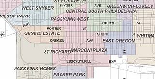
Marconi Plaza is an urban park square located in South Philadelphia, Philadelphia, Pennsylvania, United States. The plaza was named to recognize the 20th-century cultural identity in Philadelphia of the surrounding Italian-American enclave neighborhood and became the designation location of the annual Columbus Day Parade.
Pennsport is a neighborhood in the South Philadelphia section of Philadelphia, Pennsylvania, United States.
University Park is a neighborhood in the north section of Portland, Oregon on the east shore of the Willamette River. University Park is bounded by North Lombard Street and the Portsmouth neighborhood to the north, North Chautauqua Boulevard and the Arbor Lodge neighborhood to the east, The Willamette River and Mock's Bottom industrial area to the south, and the North Portland railroad cut with Cathedral Park and St. Johns neighborhoods to the west.

Spring Garden is a neighborhood in central Philadelphia, Pennsylvania, United States, bordering Center City on the north. Spring Garden is a neighborhood that combines diverse residential neighborhoods and significant cultural attractions. The residential areas on the north side of the neighborhood are composed mostly of brick and brownstone three-story townhouses built during the mid-to-late 19th century. The houses include townhouses in the Italianate style, Second Empire, Queen Anne, and Venetian Gothic. Many streets include "terraced" set ups, which include a small gardened plot, often raised, in front of the house. The residential areas to the south are dominated by taller, multi-family buildings built during the 20th century. The museum area, also to the south of Spring Garden Street, includes the Rodin Museum, the Central Library of Philadelphia, and the Barnes Museum. Before consolidation of Philadelphia, Spring Garden was a district of Philadelphia County.
Whitman is a neighborhood in the South Philadelphia section of Philadelphia, Pennsylvania, United States. It is bounded on the west by Sixth Street, on the east by Front Street, on the south by Bigler Street, and on the north by Snyder Avenue. The name "Whitman" was adopted when the nearby Walt Whitman Bridge was being constructed in the 1950s. In 2015, Whitman and nearby South Philadelphia neighborhoods were named by Philadelphia Magazine as one of the safest and most family-friendly neighborhoods in Philadelphia.
Newbold is a neighborhood in South Philadelphia, Pennsylvania, United States. Its boundaries are Broad Street on the east, 18th Street on the west, Washington Avenue on the north, and Passyunk Avenue on the south.

East Passyunk Crossing is a neighborhood in South Philadelphia, Pennsylvania, United States. Its location is considered to be from Tasker Street to Snyder Avenue and Broad Street to 6th Street.

Snyder station is a rapid transit passenger rail station on SEPTA's Broad Street Line in South Philadelphia, Pennsylvania. It is located at 2100 South Broad Street in the Lower Moyamensing neighborhood and is named for Snyder Avenue.

Central South Philadelphia, commonly known as either just South Philadelphia or "South Philly," is a neighborhood in South Philadelphia, Pennsylvania, United States. It is generally bounded by Broad to 9th Streets and Mifflin to Shunk. The entire neighborhood falls under the 19148 zip code. The neighborhood has a large Italian American population.
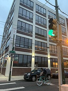
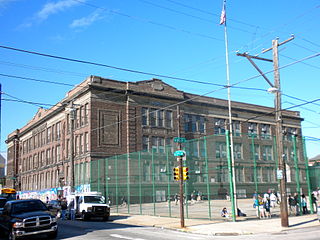
Mastery Charter School Thomas Campus, formerly the George C. Thomas Junior High School, is a secondary charter school located in the south section of Philadelphia, Pennsylvania. It is run by Mastery Charter Schools. It is located at the intersection of 9th and Johnston Streets just north of the South Philadelphia Sports Complex. Nearby are the residential neighborhoods of Marconi Plaza, Lower Moyamensing, and Packer Park; the recreational parkland of FDR Park; and the historical and new business-development center of the Philadelphia Naval Shipyard. The school is located within the boundaries of the Sports Complex Special Services District, directly on the Oregon Avenue urban corridor of small shops and restaurants anchored by larger shopping plazas on the east and west end of Oregon Avenue, and near the revitalized commercial area of Passyunk Avenue. It shares a site with the D. Newlin Fell School.

Dickinson Square West is a neighborhood in South Philadelphia, Pennsylvania, United States bordered by neighborhoods Queen Village to the north, Whitman to the south, Pennsport to the east and Passyunk Square and East Passyunk Crossing to the west. The neighborhood was previously referred to as "Dickinson Narrows", but was officially reestablished as "Dickinson Square West" in 2013 by the Registered Community Organization, Dickinson Square West Civic Association, located within its boundaries. In October, 2018, The Dickinson Square West Civic Association passed an amendment to expand the southern boundary from Mifflin Street to Snyder Ave