List of Philadelphia neighborhoods

Last updated

Unofficial map of the neighborhoods of Philadelphia Philadelphia Neighborhood Map.svg
Unofficial map of the neighborhoods of Philadelphia
Philadelphia Planning Analysis sections PhilaDistrict.PNG
Philadelphia Planning Analysis sections

The following is a list of neighborhoods, districts and other places located in the city of Philadelphia, Pennsylvania, United States. The list is organized by broad geographical sections within the city.

Contents

Common usage for Philadelphia's neighborhood names does not respect "official" borders used by the city's police, planning commission or other entities. Therefore, some of the places listed here may overlap geographically, and residents do not always agree where one neighborhood ends and another begins. Philadelphia has 41 ZIP-codes, which are often used for neighborhood analysis. [1]

Historically, many neighborhoods were defined by incorporated townships (Blockley, Roxborough), districts (Belmont, Kensington, Moyamensing, Richmond) or boroughs (Bridesburg, Frankford, Germantown, Manayunk) before being incorporated into the city with the Act of Consolidation of 1854. [2] Adding further complication is the fact that in some parts of Philadelphia, especially the central areas of North, West and South Philadelphia, residents have long been more likely to identify with the name of their section of the city than with any specific neighborhood name. Today, community development corporations, neighborhood watches and other civic organizations are influential in shaping the use of neighborhood names and approximate boundaries.

For planning purposes, the city is divided into 18 Planning Analysis Sections, which are Upper Far Northeast, Lower Far Northeast, Lower Northwest, Lower Southwest, University Southwest, West, West Park, Lower Northeast, River Wards, Lower North, North, Central, South, Lower South, Upper Northwest, Upper North, Central Northeast and North Delaware. [3]

Center City

Philadelphia City Hall in Center City The Philadelphia City Hall.JPG
Philadelphia City Hall in Center City

The Center City Planning Analysis Section extends from South Street on the south to Vine Street on the north and from the Delaware River on the east to the Schuylkill River on the west. [2]

South Philadelphia

The South Philadelphia Planning Analysis Section is bounded by South Street on the north and the Delaware and Schuylkill Rivers to their confluence. [2]

Southwest Philadelphia

Philadelphia International Airport in Southwest Philadelphia Philadelphia International Airport.jpg
Philadelphia International Airport in Southwest Philadelphia

Southwest Philadelphia (formerly Kingsessing Township) is a section of Philadelphia, Pennsylvania that can be described as extending from the western side of the Schuylkill River to the city line, with the northern border defined by the Philadelphia City Planning Commission as east from the city line along Baltimore Avenue moving south along 51st Street to Springfield Ave. It follows the train tracks until 49th Street. From 49th and Kingsessing Ave the line moves east along Kingsessing Ave. The line then moves south along 46th St to Paschall Ave where it jogs to join Grays Ferry where the line runs to the Schuylkill River. [10]

West Philadelphia

West Philadelphia, nicknamed West Philly, is a section of Philadelphia. Though there is no official definition of its boundaries, it is generally considered to reach from the western shore of the Schuylkill River, to City Line Avenue to the northwest, Cobbs Creek to the southwest and the SEPTA Media/Wawa Line to the south.

48th and Walton Streets, Cedar Park Row Houses, West Philly.jpg
48th and Walton Streets, Cedar Park

Lower North Philadelphia

Lower North Philadelphia is a section of Philadelphia that is immediately north of Center City and below Upper North Philadelphia and can be described as a section of Philadelphia that was designated as a "Model City" target, in hopes of overcoming poverty and blight through a federal funding program since 1966. Bounded by Spring Garden Street to the south, Front Street to the east, York Street to the north and Fairmount Park to the west. [11]

Upper North Philadelphia

Lillian Marrero Branch of the Philadelphia Free Library in West Kensington Phila FLP LehighAvenue02.png
Lillian Marrero Branch of the Philadelphia Free Library in West Kensington

The area is bounded by York Street to the south, Front Street to the east, Lincoln Highway/Roosevelt Expressway to the north, and Ridge Avenue/Fairmount Park to the west. Upper North Philadelphia, is a section of Philadelphia that is immediately north of Lower North Philadelphia and can be described as an area that has a "...large and rapidly growing Puerto Rican population". [12] The list of communities in this section is as follows:

Roxborough-Manayunk

Manayunk skyline Manayunk.JPG
Manayunk skyline

The Roxborough-Manyunk section of Philadelphia is an official planning district of the Philadelphia City Planning Commission, consisting of the namesake boroughs of Roxborough and Manayunk. [13] Geographically, the area is northwest of Center City.

Germantown-Chestnut Hill

The Germantown-Chestnut Hill section of Philadelphia, also referred to "Uptown" is about 7–8 miles northwest from the center of the city. The neighborhood of Germantown is rich in historic sites and buildings from the colonial era, a few of which are open to the public. Its namesake also comes from the village of Chestnut Hill, which was part of the German Township laid out by Francis Daniel Pastorius and came to include the settlements originally known as Sommerhausen and Crefeld, as well as part of Cresheim. The area generally served as a gateway between Philadelphia and the nearby farmlands. During the American Revolutionary War era (late 18th century), the area was one of many summer vacation spots due to its higher elevation, 400–500 feet (120 to 150 m) above sea level, and cooler temperatures than the historic Center City. Chestnut Hill is still stereotypically known as one of the more affluent sections of Philadelphia.

Olney-Oak Lane

The Olney-Oak Lane Planning Analysis Section is an official section of Philadelphia. It is a section of Philadelphia that is immediately north of Upper North Philadelphia and south of Cheltenham. It is an area that consists of the now defunct township that was called "Bristol Township, Philadelphia County, Pennsylvania". The section is often included as part of North Philadelphia by city government agencies, [14] though locally it is often referred to as "Uptown", along with the Germantown-Chestnut Hill section.

The section includes neighborhoods in the center-north of the city:

River Wards

The River Wards section of Philadelphia is located to the northeast of Center City, along the Delaware River. [15] [16] [17] [18]

Neighborhoods within the River Wards include:

Near Northeast Philadelphia

Richmond Street, one of the area's main thoroughfares in Port Richmond, 2005 Richmond st phila.jpg
Richmond Street, one of the area's main thoroughfares in Port Richmond, 2005

Near Northeast Philadelphia, is a section of the city of Philadelphia. When combined with the Far Northeast, to be "Northeast Philadelphia", the 2000 Census shows that the combined area has a sizable percentage of the city's 1.547 million people [19] — a population of between 300,000 and 450,000, depending on how the area is defined. Beginning in the 1980s, many of the Northeast's middle class children graduated from college and settled in suburbs, especially nearby Bucks County. An influx of Hispanics has occurred in the Northeast, while African Americans and Asian immigrants have purchased homes in Northeast Philadelphia. The Northeast is now both racially and ethnically diverse and has a large immigrant population.

Far Northeast Philadelphia

Bustleton and Byberry Streets in Somerton PA 532 SB past Byberry Road.JPG
Bustleton and Byberry Streets in Somerton

Far Northeast Philadelphia is an official planning section of Philadelphia that is north of the Near Northeast section of Philadelphia.

Related Research Articles

<span class="mw-page-title-main">Philadelphia County, Pennsylvania</span> County in Pennsylvania, United States

Philadelphia County is the most populous county in Pennsylvania and the 24th-most populous county in the nation. As of the 2020 census, the county had a population of 1,603,797. Its county seat is Philadelphia, the nation's sixth-largest city.

<span class="mw-page-title-main">Roxborough, Philadelphia</span> Neighborhood in Philadelphia, Pennsylvania, United States

Roxborough is a neighborhood in the Northwest section of the city of Philadelphia, Pennsylvania, United States. It is bordered to the southwest, along the Schuylkill River, by the neighborhood of Manayunk, along the northeast by the Wissahickon Creek section of Fairmount Park, and to the southeast by the neighborhood of East Falls. Beyond Roxborough to the northwest is Montgomery County. Roxborough's ZIP code is 19128. Most of Roxborough is in Philadelphia's 21st Ward.

<span class="mw-page-title-main">Kingsessing, Philadelphia</span> Neighborhood of Philadelphia in Pennsylvania, United States

Kingsessing is a neighborhood in the Southwest section of Philadelphia, Pennsylvania, United States. On the west side of the Schuylkill River, it is next to the neighborhoods of Cedar Park, Southwest Schuylkill, and Mount Moriah, as well as the borough of Yeadon in Delaware County. It is roughly bounded by 53rd Street to the northeast, Baltimore Avenue to the northwest, Cobbs Creek and 60th Street to the southwest, and Woodland Avenue to the southeast.

<span class="mw-page-title-main">Manayunk, Philadelphia</span> Neighborhood of Philadelphia in Pennsylvania, United States

Manayunk is a neighborhood in the section of Lower Northwest Philadelphia in the state of Pennsylvania. Located adjacent to the neighborhoods of Roxborough and Wissahickon and also on the banks of the Schuylkill River, Manayunk contains the first canal begun in the United States.

<span class="mw-page-title-main">South Philadelphia</span> Neighborhood of Philadelphia, Pennsylvania

South Philadelphia, nicknamed South Philly, is the section of Philadelphia bounded by South Street to the north, the Delaware River to the east and south, and the Schuylkill River to the west. A diverse working-class community of many neighborhoods, South Philadelphia is well-known for its large Italian-American population, but it also contains large Asian American, Irish-American, African-American, and Latino populations.

<span class="mw-page-title-main">Schuylkill Expressway</span> Highway in Pennsylvania

The Schuylkill Expressway, locally known as "the Schuylkill", is a freeway through southern Montgomery County and the city of Philadelphia. It is the easternmost segment of Interstate 76 (I-76) in the U.S. state of Pennsylvania. It extends from the Valley Forge interchange of the Pennsylvania Turnpike in King of Prussia, paralleling its namesake Schuylkill River for most of the route, southeast to the Walt Whitman Bridge over the Delaware River in South Philadelphia. It serves as the primary corridor into Philadelphia from points west. Maintenance and planning for most of the highway are administered through Pennsylvania Department of Transportation (PennDOT) District 6, with the Delaware River Port Authority (DRPA) maintaining the approach to the Walt Whitman Bridge.

<span class="mw-page-title-main">East Falls, Philadelphia</span> Neighborhood of Philadelphia in Philadelphia County, Pennsylvania, United States

East Falls is a neighborhood in Lower Northwest, Philadelphia, Pennsylvania, United States. It lies on the east bank of the "Falls of the Schuylkill," cataracts submerged in 1822 by the Schuylkill Canal and Fairmount Water Works projects. East Falls sits next to the Germantown, Roxborough, Allegheny West, and the Nicetown-Tioga neighborhoods. Wissahickon Valley Park separates it from Manayunk, Philadelphia.

<span class="mw-page-title-main">Northwest Philadelphia</span> Neighborhood of Philadelphia in Philadelphia, Pennsylvania

Northwest Philadelphia is a section of the city of Philadelphia. The official boundary is Stenton Avenue to the north, the Schuylkill River to the southwest, Northwestern Avenue to the northwest, Roosevelt Boulevard to the south, and Wister Street and Stenton Avenue to the east. Conventionally, the area east of Wissahickon Creek, which comprises Germantown, Mount Airy, Chestnut Hill, and Cedarbrook, is termed the 'Upper Northwest', and the are west of the creek, which comprises Roxborough, Wissahickon, East Falls, and Manayunk, is termed the 'Lower Northwest'. The area of Philadelphia west of the Schuylkill River is known as West Philadelphia. The Philadelphia Police Department patrols two districts located within Northwest Philadelphia. The two patrol districts serving Northwest Philadelphia are the 5th and 14th districts.

<span class="mw-page-title-main">Act of Consolidation, 1854</span> 1854 Pennsylvania law

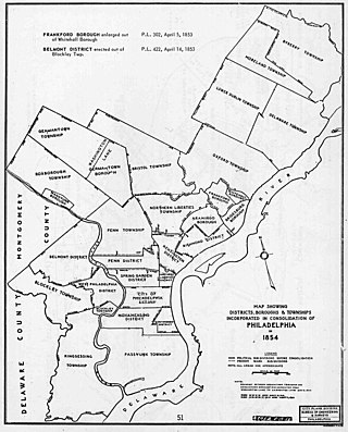
The Act of Consolidation, more formally known as the act of February 2, 1854, is legislation of the Pennsylvania General Assembly that created the consolidated City and County of Philadelphia, expanding the city's territory to the entirety of Philadelphia County and dissolving the other municipal authorities in the county. The law was enacted by the General Assembly and approved February 2, 1854, by Governor William Bigler. This act consolidated all remaining townships, districts, and boroughs within the County of Philadelphia, dissolving their governmental structures and bringing all municipal authority within the county under the auspices of the Philadelphia government. Additionally, any unincorporated areas were included in the consolidation. The consolidation was drafted to help combat lawlessness that the many local governments could not handle separately and to bring in much-needed tax revenue for the State.

<span class="mw-page-title-main">National Register of Historic Places listings in Philadelphia</span>

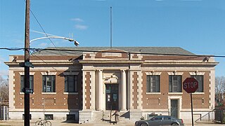
This is a list of the National Register of Historic Places listings in Philadelphia, Pennsylvania. There are more than 500 properties and districts listed on the National Register in Philadelphia, including 67 National Historic Landmarks.

Andorra is a neighborhood in Northwest Philadelphia, which is a section of the city of Philadelphia, Pennsylvania, United States. Andorra is a part of Roxborough, being within the borders of the original Roxborough Township and having the same zip code (19128). At some point during the 19th or 20th century, Andorra developed a cultural identity as a neighborhood within Roxborough. Andorra was named "Andorra" after a fancied resemblance to the small country of the same name which sits astride the Pyrenees between France and Spain.

<span class="mw-page-title-main">Southwest Philadelphia</span> Neighborhood of Philadelphia in Philadelphia, Pennsylvania

Southwest Philadelphia is a section of Philadelphia, Pennsylvania, United States. The section can be described as extending from the western side of the Schuylkill River to the city line, with the SEPTA. The northern border is defined by the Philadelphia City Planning Commission as east from the city line along Baltimore Avenue moving south along 51st Street to Springfield Ave. It follows the train tracks until 49th Street. From 49th and Kingsessing Ave the line moves east along Kingsessing Ave. The line then moves south along 46th St to Paschall Ave where it jogs to join Grays Ferry where the line runs to the Schuylkill River.

<span class="mw-page-title-main">Pennsylvania Route 291</span> State highway in Pennsylvania, US

Pennsylvania Route 291 is an east–west state route in Pennsylvania that runs from U.S. Route 13 and US 13 Business in Trainer, Delaware County, east to Interstate 76 (I-76) in South Philadelphia near the Walt Whitman Bridge and the South Philadelphia Sports Complex. Except for a short 1-mile (1.6 km) section between the western terminus and the Chester/Trainer line, PA 291 is mostly a four-lane highway. From the western terminus to the eastern part of Chester, the route has a concurrency with US 13. It runs parallel to the Delaware River for much of the route. The route passes through industrial areas near the river in Delaware County, serving Chester, Eddystone, Essington, and Lester. PA 291 enters Philadelphia near the Philadelphia International Airport, at which point it has an interchange with I-95. The route crosses the Schuylkill River on the George C. Platt Memorial Bridge and continues along Penrose Avenue to I-76. It has been designated the Industrial Heritage Highway.

<span class="mw-page-title-main">Schuylkill River Trail</span> Multi-use trail in Pennsylvania, United States

The Schuylkill River Trail is a multi-use trail along the banks of the Schuylkill River in southeastern Pennsylvania. Partially complete as of 2018, the trail is ultimately planned to run about 140 miles (230 km) from the river's headwaters in Schuylkill County to Fort Mifflin in Philadelphia.

<span class="mw-page-title-main">U.S. Route 13 in Pennsylvania</span> Highway in Pennsylvania

U.S. Route 13 (US 13) is a United States Numbered Highway running from Fayetteville, North Carolina, north to Morrisville, Pennsylvania. The route runs for 49.359 miles (79.436 km) through the Delaware Valley in the U.S. state of Pennsylvania. The route enters the state from Delaware in Marcus Hook, Delaware County. It continues northeast through Delaware County, passing through the city of Chester before heading through suburban areas along Chester Pike to Darby. US 13 enters the city of Philadelphia on Baltimore Avenue and runs through West Philadelphia to University City, where it turns north along several city streets before heading east across the Schuylkill River along Girard Avenue. The route turns north and heads to North Philadelphia, where it runs northeast along Hunting Park Avenue. US 13 becomes concurrent with US 1 on Roosevelt Boulevard, continuing into Northeast Philadelphia. US 13 splits southeast on a one-way pair of streets before heading northeast out of the city on Frankford Avenue. The route continues into Bucks County as Bristol Pike, heading northeast to Bristol, where it turns into a divided highway. US 13 becomes a freeway in Tullytown and continues north to its terminus at US 1 in Falls Township, near Morrisville. US 13 roughly parallels Interstate 95 (I-95) through its course in Pennsylvania.

<span class="mw-page-title-main">Wissahickon, Philadelphia</span> Neighborhood of Philadelphia in Philadelphia County, Pennsylvania, United States

Wissahickon is a neighborhood in the section of Lower Northwest Philadelphia in the state of Pennsylvania, United States. Wissahickon is located adjacent to the neighborhoods of Roxborough and Manayunk, and it is bounded by the Wissahickon Valley Park, Ridge Avenue, Hermit Street, and Henry Avenue. The name of the neighborhood is derived from the Lenni Lenape word wisameckham, for "catfish creek", a reference to the fish that were once plentiful in the Wissahickon Creek.

The Food Trust is a nonprofit organization. It was founded in 1992 by Duane Perry in Philadelphia, Pennsylvania. The current executive director is Yael Lehmann. The goal of the organization is to improve the health of children and adults by providing better nutrition. The Food Trust works with neighborhoods, schools, grocers, farmers and policymakers to implement a comprehensive approach to improved food access that combines nutrition education and greater availability of affordable, healthy food. It is currently operating 25 farmer's markets in the Philadelphia region. The markets accept SNAP/food stamps, Farmers’ Market Nutrition Program vouchers and Philly Food Bucks. The Food Trust is funded by private foundations, government grants, and individual donors.

The Manayunk Expressway was a proposed parkway that was to run along the east bank of the Schuylkill River similar to the Moses parkways of New York City, first proposed in 1932 by the Regional Planning Federation. It was originally designed to connect Fairmount Park in Philadelphia with Norristown. The purpose was to have served as an alternate route to the Schuylkill Expressway and Germantown Pike that by 1960 had become congested.

<span class="mw-page-title-main">Girard Avenue</span> Major commercial and residential street in Philadelphia, Pennsylvania, United States

Girard Avenue is a major commercial and residential street in Philadelphia. For most of its length it runs east–west, but at Frankford Avenue it makes a 135-degree turn north. Parts of the road are signed as U.S. Route 13 and U.S. Route 30.

Ridge Pike is a major historic road in the U.S. state of Pennsylvania that opened in 1706 that originally connected Wissahickon Creek to Perkiomen Creek. Inside Philadelphia, it is called Ridge Avenue. Going westward, it traverses many eastern Pennsylvania neighborhoods in Montgomery County including Conshohocken and beyond, connecting with Germantown Pike near Collegeville and continuing to Pottstown. In Montgomery County, Ridge Pike is called Main Street in the Norristown area and again in Collegeville and Trappe, and is called High Street in the Pottstown area.

References

  1. Homeownership in Philadelphia: On the Decline (PDF). Pew Charitable Trusts. July 1, 2014. Retrieved September 24, 2017.
  2. 1 2 3 The Political and Community Service Boundaries of Philadelphia, Philadelphia City Planning Commission, June 2004.
  3. https://e3ba9c74-53df-4258-bdf7-9601132a34ba.filesusr.com/ugd/32cb1b_e695bf0dda42479b9dbb07f7d61a98c3.pdf [ bare URL PDF ]
  4. Fitler Square Improvement Association. Accessed 4 February 2009.
  5. Society Hill Civic Association. "About SHCA". Accessed 2 February 2009.
  6. 11th to Broad streets, and from Pine to Locust
  7. Bella Vista Town Watch. "Map of Bella Vista". Accessed 2 February 2009.
  8. South Philly Review . "The Place Where You Live: Hawthorne Archived 2007-09-27 at the Wayback Machine ". Accessed 4 February 2009.
  9. Queen Village Neighbor's Association. "Life in Queen Village". Accessed 4 February 2009.
  10. Philadelphia City Planning Commission Archived 2011-03-07 at the Wayback Machine
  11. Carolyn Teich Adams (November 2, 1988). The Politics of Capital Investment: The Case of Philadelphia. SUNY Press. ISBN   9780887068485.
  12. Guian A. McKee (June 15, 2010). The Problem of Jobs: Liberalism, Race, and Deindustrialization in Philadelphia. University of Chicago Press. ISBN   9780226560144.
  13. Roxborough Manayunk District Plan. 1983.
  14. "OpenDataPhilly - Planning Analysis Sections". Archived from the original on October 27, 2014. Retrieved October 27, 2014.
  15. "Fishtown and the River Wards".
  16. "River Wards".
  17. https://www.dvrpc.org/mapping/maps/pdf/Philadelphia_Planning_Districts.pdf [ bare URL PDF ]
  18. "In booming Philadelphia neighborhoods, lead-poisoned soil is resurfacing".
  19. "Philadelphia County Quick Facts". US Census Bureau Official Website. US Census Bureau. August 16, 2009. Archived from the original on August 1, 2011. Retrieved August 16, 2009.