Logan Circle (Philadelphia)

Last updated

Logan Square
Logan Circle (Philadelphia) crop.JPG
Swann Memorial Fountain in Logan Circle
Street map of Philadelphia and surrounding area.png
Red pog.svg
USA Pennsylvania location map.svg
Red pog.svg
Usa edcp location map.svg
Red pog.svg
Location Philadelphia, Pennsylvania, U.S.
Coordinates 39°57′28.16″N75°10′15.35″W / 39.9578222°N 75.1709306°W / 39.9578222; -75.1709306
Built1684
Architect Thomas Holme; Jacques Greber
MPS Four Public Squares of Philadelphia TR
NRHP reference No. 81000555 [1]
Added to NRHPSeptember 14, 1981

Logan Circle, also known as Logan Square, is an open-space park in Center City Philadelphia's northwest quadrant and one of the five original planned squares laid out on the city grid. The centerpiece of the park is the Logan Circle, a circular area centered on a large water feature, bounded by a traffic circle carrying 19th Street and the Benjamin Franklin Parkway with connections to 18th and 20th streets to the east and west and Race and Vine Streets to the south and north.

Contents

The circle exists within the original bounds of the square; the names Logan Square and Logan Circle are used interchangeably when referring to the park. Originally "Northwest Square" in William Penn's 1684 plan for the city, the square was renamed in 1825 after Philadelphia statesman James Logan. [2] The park is the focal point of the eponymous neighborhood.

Logan Square was added to the National Register of Historic Places in 1981. [3]

History

19th century

Parkway Central Library and Philadelphia's Family Court Building Logan Square.JPG
Parkway Central Library and Philadelphia's Family Court Building
Both buildings were modeled after the Hotel de Crillon, and the Hotel de la Marine Place de la Concorde in Paris Paris Place de la Concorde N Rue de Rivoli 02.jpg
Both buildings were modeled after the Hôtel de Crillon, and the Hôtel de la Marine Place de la Concorde in Paris

Prior to the 1800s the city developed along the Delaware River, leaving the area around Logan Square as untouched forest through the American Revolution. [4] Over the next quarter century the square served as a pasture, graveyard, and execution grounds which hosted a gallows until the hanging of William Gross on February 7, 1823. The City of Philadelphia leased the square to the Orphans' Society from 1821 to 1830. [2] While some have suggested that the lease for a “good and noble purpose” was an aim at redirecting public attention away from its previous morbid use following Gross’s death, that is probably revisionist since the lease was executed two full years prior to the last public hanging in the “city of brotherly love”.

In 1842, an ordinance “made it an offense to drive or take into Logan, Penn, or Rittenhouse squares any ‘horse, cow, cart, wagon, carriage or wheelbarrow, except by permission, or place any wood, coal, rubbish, carrion, or offensive matter within either [sic] of the squares, or to climb on the trees, fences or gates . . . or to dig up the soil or injure the grass, or to run or walk over or lie on the same.’” [5] By the 1840s Philadelphia had begun a restoration of the square from its former days as a graveyard, lining the walks with trees, planting greenery and shrubbery, and constructing a wooden fence allowing the square to resemble Penn's vision of an urban green space. During this period, the city limited access to Logan Square to homeowners with property connected to the square who paid for its upkeep; the city constructed a wrought iron fence around the square in 1852. [2]

In 1864, the square was the site of the Great Sanitary Fair, a fundraising event in support of the United States Sanitary Commission to help raise money, support, and buy medicine for the Union troops during the American Civil War. President Abraham Lincoln visited the fair and donated forty-eight signed copies of the Emancipation Proclamation, which sold for $10 each. [6] In 1881 the Pennsylvania Railroad constructed a viaduct that disconnected Logan Square and Rittenhouse Square, altering William Penn’s original plan of connectivity between the city's five squares. [5]

The square was used as a location for concerts and other community events. [7]

Since the 1890s, the city had envisioned constructing of a boulevard similar to the Parisian Champs-Élysées.

20th century

In 1907, the plans were approved. [4] The square began to transform again: the original bounds of the square were 18th Street to the east, 20th Street to the west, Race Street to the south, and Vine Street to the north remain intact, and the square began to more closely resemble its appearance today, distinguished by its circle.

Construction began in 1917 on a plan to connect Center City with Fairmount Park which later became a segment of Benjamin Franklin Parkway. [8] It was designed by Jacques Gréber, a French landscape architect who converted Logan Square into a circle similar to the oval of the Place de la Concorde in Paris. [9] Philadelphia even modeled its Free Library and Family Court Building after the twin buildings of the Hôtel de Crillon and the Hôtel de la Marine in Paris.

Among the sites in its immediate vicinity are the Swann Memorial Fountain at the center of the circle, Parkway Central Library, the former Philadelphia Family Court Building, the Academy of Natural Sciences, the Franklin Institute, Moore College of Art and Design, the Roman Catholic Cathedral-Basilica of Sts. Peter and Paul, and the Mormon Philadelphia Pennsylvania Temple. [10]

21st century

In early 2005, the Pennsylvania Horticultural Society (PHS) began efforts to clean up and redevelop the park to make it more accessible and inviting to pedestrians. Most noticeably the large paulownia trees that featured prominently round the fountain were removed. City planners with PHS had determined that they had reached the end of their life span and had become an eyesore. They were replaced with similar trees grown especially for Logan Square at Longwood Gardens as part of a larger plan to improve the space. PHS planted lush perennial gardens around the fountain and adjacent parcels and maintain the gardens throughout the year. [11]

The city undertook an extensive rehabilitation plan and by 2012 the city had refurbished the original squares with restoration and new greenery bringing the Parkway’s entertainment capabilities full-circle. [12]

The city has expressed support of transitioning the circle back into a square, and increasing its aesthetic nature as an urban green space. [13]

Events

When Pope John Paul II visited the city in 1979, he celebrated mass in the plaza on October 3, 1979. [14]

To commemorate the end of every school year since the 1960s, the newly appointed Sophomores, Juniors, and Seniors of J. W. Hallahan Catholic Girls High School jump into the fountain. The event is the subject of much local media coverage throughout Philadelphia.[ citation needed ]

In 2016, it was the starting location for the Women's March on Philadelphia. [15]

In April 2017, Logan Circle hosted the 2017 NFL Draft. [15]

The circle is the subject of the local band The Wonder Years' song "Logan Circle" from their studio album The Upsides .

See also

Related Research Articles

<span class="mw-page-title-main">Centennial Exposition</span> First official Worlds Fair held in the US, 1876

The Centennial International Exhibition, officially the International Exhibition of Arts, Manufactures, and Products of the Soil and Mine, was held in Philadelphia from May 10 to November 10, 1876. It was the first official world's fair to be held in the United States, and coincided with the centennial anniversary of the Declaration of Independence's adoption in Philadelphia on July 4, 1776.

<span class="mw-page-title-main">Rittenhouse Square</span> Public park in Philadelphia, Pennsylvania, United States

Rittenhouse Square is a neighborhood, including a public park, in Center City Philadelphia, Pennsylvania. Rittenhouse Square often specifically refers to the park, while the neighborhood as a whole is referred to simply as Rittenhouse. The park is one of the five original open-space parks planned by William Penn and his surveyor Thomas Holme during the late 17th century.

<span class="mw-page-title-main">Center City, Philadelphia</span> Neighborhood in Philadelphia, Pennsylvania

Center City includes the central business district and central neighborhoods of Philadelphia, Pennsylvania, United States. It comprises the area that made up the City of Philadelphia prior to the Act of Consolidation, 1854, which extended the city borders to be coterminous with Philadelphia County.

<span class="mw-page-title-main">Benjamin Franklin Parkway</span> Notable parkway in Philadelphia

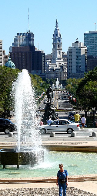
Benjamin Franklin Parkway, commonly abbreviated to Ben Franklin Parkway and colloquially called the Parkway, is a boulevard that runs through the cultural heart of Philadelphia, the nation's sixth-largest city as of 2020.

<i>Swann Memorial Fountain</i> Fountain by Alexander Stirling Calder

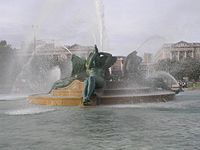
The Swann Memorial Fountain is an art deco fountain sculpture located in the center of Logan Circle in Philadelphia, Pennsylvania, United States.

<span class="mw-page-title-main">Broad Street (Philadelphia)</span> Thoroughfare in Pennsylvania

Broad Street is a major arterial street in Philadelphia, Pennsylvania. The street runs for approximately 13 miles (21 km), beginning at the intersection of Cheltenham Avenue on the border of Cheltenham Township and the West/East Oak Lane neighborhoods of North Philadelphia to the Philadelphia Navy Yard in South Philadelphia. It is Pennsylvania Route 611 along its entire length with the exception of its northernmost part between Old York Road and Pennsylvania Route 309 and the southernmost part south of Interstate 95.

<span class="mw-page-title-main">Logan Square, Philadelphia</span> Neighborhood of Philadelphia in Pennsylvania, United States

Logan Square is a neighborhood in Philadelphia, Pennsylvania, United States. Bounded by Market Street on the south, Spring Garden Street on the north, Broad Street on the east, and the Schuylkill River on the west, it occupies the northwestern quadrant of Center City. The square for which it is named is one of the five squares central to William Penn's design for Philadelphia. Originally called Northwest Square, it was renamed in honor of James Logan, an 18th-century mayor of Philadelphia.

<span class="mw-page-title-main">Franklin Square (Philadelphia)</span> United States historic place

Franklin Square is one of the five original open-space parks planned by William Penn when he laid out the city of Philadelphia, Pennsylvania, in 1682. It is located in the Center City area, between North 6th and 7th streets, and between Race Street and the Vine Street Expressway (I-676).

<span class="mw-page-title-main">Marconi Plaza</span> Urban park square in Philadelphia

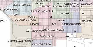
Marconi Plaza is an urban park square located in South Philadelphia, Philadelphia, Pennsylvania, United States. The plaza was named to recognize the 20th-century cultural identity in Philadelphia of the surrounding Italian American enclave neighborhood and became the designation location of the annual Columbus Day Parade.

<span class="mw-page-title-main">Eakins Oval</span> Traffic circle in Pennsylvania, US

Eakins Oval is a traffic circle in Philadelphia. It forms the northwest end of the Benjamin Franklin Parkway just in front of the Philadelphia Museum of Art, with a central array of fountains and monuments, and a network of pedestrian walkways.

SEPTA Route 38 is a bus and former Subway-Surface streetcar route operated by the Southeastern Pennsylvania Transportation Authority (SEPTA) in Philadelphia, Pennsylvania, United States.

<span class="mw-page-title-main">Eli Kirk Price II</span> American lawyer

Eli Kirk Price II was a prominent American Philadelphia lawyer, called "the foremost civic and cultural leader in early twentieth-century Philadelphia". He was the commissioner of Fairmount Park during the planning and development of the Benjamin Franklin Parkway, of which he was one of the principal planners. Later, he was instrumental in obtaining funding for the new Philadelphia Museum of Art building and was President of the museum from 1926 to 1933.

<span class="mw-page-title-main">Vine Street (Philadelphia)</span> Street in Philadelphia, United States of America

Vine Street is a major east-west street in Center City Philadelphia. It begins at the Delaware River and proceeds west to 20th Street, where it merges with the Benjamin Franklin Parkway.

<span class="mw-page-title-main">Philadelphia Parks & Recreation</span>

Philadelphia Parks & Recreation (PPR) is the municipal department responsible for managing parks, recreation centers, playgrounds, trails, community gardens, and historic properties in Philadelphia, Pennsylvania. Its inventory includes more than 150 parks and 170 recreation centers and playgrounds. It became the successor to the Fairmount Park Commission and the City of Philadelphia Department of Recreation in 2010.

<span class="mw-page-title-main">All Wars Memorial to Colored Soldiers and Sailors</span> War memorial in Philadelphia, Pennsylvania, U.S.

All Wars Memorial to Colored Soldiers and Sailors is a war memorial in Philadelphia, Pennsylvania that honors the state's African American servicemen who fought in American conflicts from the American Revolutionary War to World War I. Commissioned by the Commonwealth of Pennsylvania in 1927, it was created by sculptor J. Otto Schweizer and dedicated July 7, 1934. In 1994 it was relocated from a remote site in West Fairmount Park to its present prominent site in Logan Square, along the Benjamin Franklin Parkway.

<span class="mw-page-title-main">Drinking fountains in Philadelphia</span> Public drinking fountains in the U.S. city of Philadelphia

Public drinking fountains in Philadelphia, Pennsylvania, United States, have been built and used since the 19th century. Various reform-minded organizations in the city supported public drinking fountains as street furniture for different but overlapping reasons. One was the general promotion of public health, in an era of poor water and typhoid fever. Leaders of the temperance movement such as the Woman's Christian Temperance Union saw free, clean water as a crucial alternative to beer. Emerging animal welfare organizations, notably the Society for the Prevention of Cruelty to Animals, wanted to provide water to the dogs and working horses of the city on humanitarian grounds, which is why Philadelphia's drinking fountains of the era often include curb-level troughs that animals could reach.

Wilson Cary Swann was an American physician, philanthropist, and social reformer. Born in present-day Alexandria, Virginia, he moved to Philadelphia in 1847, and spent the rest of his life there. Swann held around 40 slaves, whom he freed shortly after his marriage in 1847.

References

  1. "National Register Information System". National Register of Historic Places . National Park Service. January 23, 2007.
  2. 1 2 3 Scharf, John Thoman; Westcott, Thompson (1884). History of Philadelphia, 1609-1884, Volume 3. Philadelphia, Pennsylvania: L. H. Everts & Company. pp. 1848–1849.
  3. "Asset Detail". npgallery.nps.gov. Retrieved May 4, 2017.
  4. 1 2 "History - lsnaphilly". www.lsnaphilly.org. Retrieved May 4, 2017.
  5. 1 2 Milroy, Elizabeth (Spring 2011). "Repairing the Myth and the Reality of Philadelphia's Public Squares, 1800-1850". Change over Time. 1: 52–78. doi:10.1353/cot.2011.a430737.
  6. Bryan, Kerry L. (2012). "Civil War Sanitary Fairs". The Encyclopedia of Greater Philadelphia.
  7. "The City's Band. When and Where the Municipal Musicians May be Heard". The Philadelphia Inquirer. May 19, 1898.
  8. Tanenbaum, Michael (March 12, 2016). "ACT CEO: Turn Philly's Logan Circle back into a square". Philly Voice.
  9. "The Central Library and Logan Circle: New Public Spaces". City of Philadelphia.
  10. "Philadelphia Pennsylvania Temple". www.ldschurchtemples.com. Retrieved May 4, 2017.
  11. Schwartz, Christopher (September 2005). "Squaring the Circle". My City Paper.
  12. Schwartz, Chris (September 2005). "Squaring the Circle". My City Paper.
  13. "ACT CEO: Turn Philly's Logan Circle back into a square". PhillyVoice. March 12, 2016. Retrieved May 9, 2017.
  14. "A look back at Pope John Paul II's visit to Philadelphia in 1979". WHYY. Retrieved December 10, 2019.
  15. 1 2 "Logan Square: from public executions to papal visits to world-class museums". PhillyVoice. March 14, 2017. Retrieved May 9, 2017.