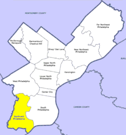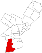
Kingsessing is a neighborhood in the Southwest section of Philadelphia, Pennsylvania, United States. On the west side of the Schuylkill River, it is next to the neighborhoods of Cedar Park, Southwest Schuylkill, and Mount Moriah, as well as the borough of Yeadon in Delaware County. It is roughly bounded by 53rd Street to the northeast, Baltimore Avenue to the northwest, Cobbs Creek and 60th Street to the southwest, and Woodland Avenue to the southeast.

Cedar Park is a neighborhood of Philadelphia, Pennsylvania, United States. Located in the larger West Philadelphia district, it stretches north to Larchwood Ave., south to Kingsessing Ave., east to 46th Street, and west to 52nd Street.

West Philadelphia, nicknamed West Philly, is a section of the city of Philadelphia. Although there are no officially defined boundaries, it is generally considered to reach from the western shore of the Schuylkill River, to City Avenue to the northwest, Cobbs Creek to the southwest, and the SEPTA Media/Wawa Line to the south. An alternate definition includes all city land west of the Schuylkill; this would also include Southwest Philadelphia and its neighborhoods. The eastern side of West Philadelphia is also known as University City.

Cobbs Creek is an 11.8-mile-long (19.0 km) tributary of Darby Creek in Delaware County, Pennsylvania, in the United States. It forms an approximate border between Montgomery County and Delaware County. After Cobbs Creek passes underneath Township Line Road, it forms the border between Philadelphia County and Delaware County. It runs directly through the two sides of Mount Moriah Cemetery which spans the border of Southwest Philadelphia and Yeadon, Pennsylvania. It later joins Darby Creek before flowing into the Delaware River.

Interstate 695 (I-695) was an auxiliary Interstate Highway that was proposed in 1964 to connect I-95 in Southwest Philadelphia, at Philadelphia International Airport, with I-95 near the Delaware River waterfront near the Benjamin Franklin Bridge. Known as the Cobbs Creek Expressway between Southwest Philadelphia and I-76 and the Crosstown Expressway between I-76 and the waterfront, I-695 was designed to provide connections to Philadelphia International Airport and become part of a Center City Loop, with the Crosstown Expressway being the southern section of that loop.
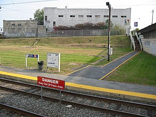
Angora station is a SEPTA railway station in Philadelphia. It serves the Media/Wawa Line and is officially located at 58th Street near Baltimore Avenue in Southwest Philadelphia's Angora neighborhood, however the actual location is south of Baltimore Avenue. Part of Cobbs Creek Parkway runs along 58th Street from Baltimore Avenue, over the railroad bridge, to nearby Hoffman Avenue. In 2013, this station saw 36 boardings and 37 alightings on an average weekday, making it SEPTA's least used regional rail station.

Route 11, also known as the Woodland Avenue Line, is a trolley line operated by the Southeastern Pennsylvania Transportation Authority (SEPTA) that connects the 13th Street station in downtown Philadelphia, Pennsylvania, to Darby Transportation Center in Darby, Pennsylvania. It is one of five lines that are part of the subway–surface trolley system. Sitting at an average of 13,580 riders per weekday in 2019, it is the most used subway-surface trolley route, even though it lacks overnight service. From 2024 onwards, this route will be referred as T4 Woodland Avenue Line.

SEPTA Route 13, also known as the Chester Avenue Line, is a trolley line operated by the Southeastern Pennsylvania Transportation Authority (SEPTA) that connects 13th Street Station in downtown Philadelphia, Pennsylvania, with Yeadon and Darby, Pennsylvania. It is one of five lines that are part of the Subway-Surface Trolley system. From 2024 onwards, Route 13 will be referred as the T3 Chester Avenue Line

The 40th Street Portal, also known as simply 40th Street station, is a SEPTA Subway-Surface Lines trolley station in Philadelphia. At this station's portal, four of the five Subway-Surface Lines enter the Woodland Avenue subway tunnel after running on the street in Southwest Philadelphia and nearby suburbs. Eastbound trolleys run in the tunnel under the nearby campuses of the University of Pennsylvania and Drexel University to Center City Philadelphia. Westbound trolleys travel to the Philadelphia neighborhoods of Eastwick and Angora and the Delaware County suburbs of Yeadon and Darby.
SEPTA's Subway-Surface Trolley Route 36 is a trolley line operated by the Southeastern Pennsylvania Transportation Authority (SEPTA) that connects the 13th Street station in downtown Philadelphia, Pennsylvania, to the Eastwick Loop station in Eastwick section of Southwest Philadelphia, although limited service is available to the Elmwood Carhouse. It is the longest of the five lines that are part of the Subway-Surface Trolley system, and was even longer between 1956 and 1962 when the western terminus was at 94th Street and Eastwick Avenue. From 1962 through the 1970s, it was at 88th Street and Eastwick Avenue, making the route 16.2 miles (26.1 km) long. Since 1975, it only goes as far as what was once 80th Street at the southern edge of the Penrose Plaza shopping center parking lot. From 2024, Route 36 will be referred to as the T5 Elmwood Avenue Line

Blockley Township was a township that was located in Philadelphia County, Pennsylvania, United States. Incorporated in 1704, the township was incorporated into the City of Philadelphia under the 1854 Act of Consolidation.
The Baltimore Pike was an auto trail connecting Baltimore, Maryland, with Philadelphia, Pennsylvania.

Pennsylvania Route 3 is a 24.3-mile (39.1 km) state highway located in the southeastern portion of Pennsylvania. The route runs from U.S. Route 322 Business in West Chester east to PA 611 in Philadelphia.
Eastwick is a neighborhood in the Southwest section of Philadelphia, Pennsylvania, United States. It is the southwesternmost neighborhood in the city, bordering Philadelphia International Airport and the city line with Delaware County at Cobbs Creek and Darby Creek. The Elmwood Park neighborhood borders it to the northeast.
Elmwood Park, also known simply as Elmwood, is a neighborhood in the Southwest section of Philadelphia, Pennsylvania, United States. It borders the city line with Delaware County at Cobbs Creek, and extends to the Schuylkill River. The Eastwick neighborhood borders it to the southwest, and Kingsessing borders it on the northeast.

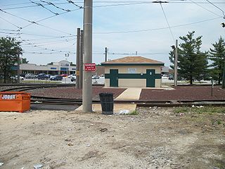
Angora is a neighborhood in the Southwest section of Philadelphia, Pennsylvania, United States. Although its boundaries are not precise, West Philadelphia is to its north, Kingsessing is to the south, Cedar Park is to the east, and Cobbs Creek is to the west. The Angora Commuter Rail Station on the Media/Wawa Line, two bus lines, and a trolley line all intersect around Baltimore Avenue and 58th Street, which is unofficially the nexus of the neighborhood.

U.S. Route 1 (US 1) is a major north–south U.S. Route, extending from Key West, Florida, in the south to Fort Kent, Maine, at the Canada–United States border in the north. In the U.S. state of Pennsylvania, US 1 runs for 81 miles (130 km) from the Maryland state line near Nottingham northeast to the New Jersey state line at the Delaware River in Morrisville, through the southeastern portion of the state. The route runs southwest to northeast and serves as a major arterial road through the city of Philadelphia and for many of the suburbs in the Delaware Valley metropolitan area. South of Philadelphia, the road mostly follows the alignment of the Baltimore Pike. Within Philadelphia, it mostly follows Roosevelt Boulevard. North of Philadelphia, US 1 parallels the route of the Lincoln Highway. Several portions of US 1 in Pennsylvania are freeways, including from near the Maryland state line to Kennett Square, the bypass of Media, the concurrency with Interstate 76 and the Roosevelt Expressway in Philadelphia, and between Bensalem Township and the New Jersey state line.

U.S. Route 13 (US 13) is a United States Numbered Highway running from Fayetteville, North Carolina, north to Morrisville, Pennsylvania. The route runs for 49.359 miles (79.436 km) through the Delaware Valley in the U.S. state of Pennsylvania. The route enters the state from Delaware in Marcus Hook, Delaware County. It continues northeast through Delaware County, passing through the city of Chester before heading through suburban areas along Chester Pike to Darby. US 13 enters the city of Philadelphia on Baltimore Avenue and runs through West Philadelphia to University City, where it turns north along several city streets before heading east across the Schuylkill River along Girard Avenue. The route turns north and heads to North Philadelphia, where it runs northeast along Hunting Park Avenue. US 13 becomes concurrent with US 1 on Roosevelt Boulevard, continuing into Northeast Philadelphia. US 13 splits southeast on a one-way pair of streets before heading northeast out of the city on Frankford Avenue. The route continues into Bucks County as Bristol Pike, heading northeast to Bristol, where it turns into a divided highway. US 13 becomes a freeway in Tullytown and continues north to its terminus at US 1 in Falls Township, near Morrisville. US 13 roughly parallels Interstate 95 (I-95) through its course in Pennsylvania.
Mingo Creek is a tributary of the Schuylkill River between the Eastwick neighborhood and Philadelphia International Airport, in the United States.