Germantown is an area in Northwest Philadelphia, United States. Founded by German, Quaker, and Mennonite families in 1683 as an independent borough, it was absorbed into Philadelphia in 1854. The area, which is about six miles northwest from the city center, now consists of two neighborhoods: 'Germantown' and 'East Germantown'.
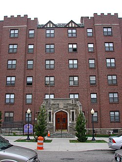
La Salle University is a private, Catholic university in Philadelphia, Pennsylvania. The university was founded in 1863 by the Institute of the Brothers of the Christian Schools and named for St. Jean-Baptiste de La Salle.

Fern Rock is a neighborhood in the upper North Philadelphia section of Philadelphia, Pennsylvania, United States, bounded by Olney to the east, Ogontz to the west, Logan to the south, and East Oak Lane to the north. It is approximately situated between Broad Street, Tabor Road, 7th Street, Godfrey Avenue and Fisher Park. Fern Rock borders Ogontz at Broad Street, Logan at Olney Avenue, East Oak Lane at Godfrey Avenue, and Olney at the train tracks.

Olney is a neighborhood in North Philadelphia, Pennsylvania, United States. It is roughly bounded by Roosevelt Boulevard to the south, Tacony Creek to the east, Godfrey Avenue to the north, and the railroad right-of-way west of Seventh Street to the west.

Mount Airy is a neighborhood of Northwest Philadelphia in the U.S. state of Pennsylvania.
West Oak Lane is a neighborhood in the Northwest Philadelphia, Pennsylvania, United States. The neighborhood was developed primarily between the early 1920s and late 1930s, with the areas near to Cedarbrook constructed after World War II. At the northeast corner of Limekiln Pike and Washington Lane was the site of the Cedar Park Inn, a historic tavern built in the early 19th century, which was torn down sometime after 1931 as the neighborhood was being fully developed.
Logan is a neighborhood in the upper North Philadelphia section of the city of Philadelphia, in the U.S. state of Pennsylvania. The majority of the neighborhood falls within the 19141 zip code, but some of it falls within 19140. The neighborhood is sometimes confused with the Olney neighborhood of Philadelphia. Olney Avenue extends from both the Olney and Logan neighborhoods of the city. The Olney Transportation Center is located in Logan.
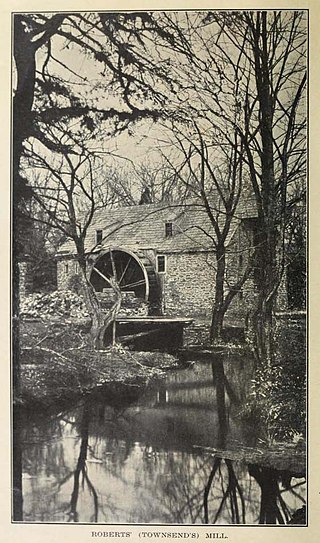
Wingohocking Creek was once a major tributary of another Philadelphia, Pennsylvania stream, Frankford Creek, which flows into the Delaware River. Frankford Creek was formed by the confluence of Wingohocking Creek and Tacony Creek. Since Wingohocking Creek is now obliterated, having been piped underground in the late 19th century, it can be confusing to look at a modern map, which shows Tacony Creek suddenly changing names "in the middle of the stream," so to speak, and becoming Frankford Creek. The point at which the name changes is near the present intersection of I and Ramona Streets, where the Wingohocking once joined the Tacony to form the Frankford Creek. What was once a major stream and the site of many mills and factories has been completely wiped off the map—all but the city's sewer maps, that is. The outlet of the Wingohocking Sewer is the largest in the Philadelphia sewer system, about 24 feet (7.3 m) high. It is visible from various points in the Juniata neighborhood and the adjoining golf course.
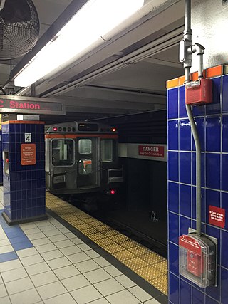
The Olney Transportation Center, also called Olney Terminal, is a SEPTA bus and subway station in Philadelphia, Pennsylvania. It is located at the intersection of Broad Street and Olney Avenue in the Logan neighborhood of North Philadelphia. It is a major bus terminal as well as the last subway stop on the Broad Street Line before the Fern Rock Transportation Center terminus.
Bristol Township is a defunct township that was located in Philadelphia County, Pennsylvania, United States. The township ceased to exist and was incorporated into the City of Philadelphia following the passage of the Act of Consolidation, 1854. It is the modern day Olney-Oak Lane Planning Analysis Section, though with a slight difference in the southern border. It is in present-day North Philadelphia, although Olney-Oak Lane is sometimes considered to be separate from North Philadelphia entirely because of their unique architecture, culture and differing patterns of development.
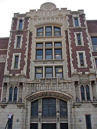
Martin Luther King High School is a neighborhood public high school located in the East Germantown section of Philadelphia, Pennsylvania. It is located at the intersection of Stenton Avenue and Haines Street in Philadelphia. It is a neighborhood school, meaning no application is necessary for those students who live in the West Oak Lane and Germantown sections of Philadelphia. It is named after Martin Luther King Jr.

Passyunk Square is a neighborhood in South Philadelphia bounded by Broad Street to the west, 6th Street to the east, Tasker Street to the south and Washington Avenue to the north. Passyunk Square is bordered by the Bella Vista, Hawthorne, Central South Philadelphia, Wharton, and Point Breeze neighborhoods. The neighborhood got its Lenape name from the 1800s Passyunk Township, Pennsylvania which named Passyunk Square Park, located between 12th, 13th, Reed and Wharton Streets. The park was eventually renamed Columbus Square Park, and subsequently the neighborhood became known as Columbus Square. Sue Montella, Geoff DiMasi, and a group of neighbors revived the Passyunk Square name when forming the Passyunk Square Civic Association in 2003.
Sarah Logan Wister Starr was a prominent member of Philadelphia society in the early 1900s and a dedicated humanitarian.

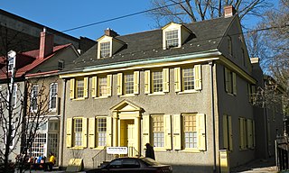
Belfield, also known as the Charles Willson Peale House, was the home of Charles Willson Peale from 1810 to 1826, and was declared a National Historic Landmark in 1965. The Belfield Estate was a 104-acre (42 ha) area of land in the Logan section of Philadelphia, Pennsylvania, much of which is now a part of La Salle University’s campus.
Wister is a neighborhood in Northwest Philadelphia, Pennsylvania, United States. It is bounded by Chelten Avenue to the north, Germantown Avenue to the west, Belfield Avenue to the east, and Wister Street to the south. Wister is a section within Germantown. The Clarkson-Watson House, Fisher's Lane, Grumblethorpe, Grumblethorpe Tenant House, and Ivy Lodge are listed on the National Register of Historic Places.
The Food Trust is a nonprofit organization. It was founded in 1992 by Duane Perry in Philadelphia, Pennsylvania. The current executive director is Yael Lehmann. The goal of the organization is to improve the health of children and adults by providing better nutrition. The Food Trust works with neighborhoods, schools, grocers, farmers and policymakers to implement a comprehensive approach to improved food access that combines nutrition education and greater availability of affordable, healthy food. It is currently operating 25 farmer's markets in the Philadelphia region. The markets accept SNAP/food stamps, Farmers’ Market Nutrition Program vouchers and Philly Food Bucks. The Food Trust is funded by private foundations, government grants, and individual donors.
Olney-Oak Lane, Philadelphia, is a section of Philadelphia that is immediately north of Upper North Philadelphia and south of Cheltenham. It is an area that consists of the now defunct township that was called "Bristol Township, Philadelphia County, Pennsylvania". The section is often included as part of North Philadelphia by city government agencies, though locally it is often referred to as "Uptown," along with the Germantown-Chestnut Hill section.
Cheltenham Avenue is a major east-west road in Southeastern Pennsylvania. It is served by many SEPTA bus routes, trolleys, regional rail, and subway. Cheltenham Avenue is an unsigned quadrant route t routes in Montgomery County, Pennsylvania. It also is a major borderline; it defines the border between Springfield and Cheltenham townships, and Cheltenham Township and the City of Philadelphia, with the latter also being the Montgomery County and Philadelphia County. A section of the road along the Philadelphia–Cheltenham border is part of PA Route 309.

Cheltenham Township is a home rule township in Montgomery County, Pennsylvania, United States. Cheltenham's population density ranges from over 10,000 per square mile in rowhouses and high-rise apartments along Cheltenham Avenue to historic neighborhoods in Wyncote and Elkins Park. It is the most densely populated township in Montgomery County. The population was 36,793 at the 2010 U.S. Census, making it the third most populous township in Montgomery County and the 27th most populous municipality in Pennsylvania. It was originally part of Philadelphia County, and it became part of Montgomery County upon that county's creation in 1784.