Wissahickon, Philadelphia

Last updated

Wissahickon
Wissahickon Neighborhood Sign.jpg
Wissahickon neighborhood gateway sign
Street map of Philadelphia and surrounding area.png
Red pog.svg
Wissahickon
Coordinates: 40°01′05″N75°11′24″W / 40.018°N 75.19°W / 40.018; -75.19
CountryFlag of the United States.svg  United States
State Pennsylvania
County Philadelphia County
City Philadelphia
Zipcode
19128
Area code(s) 215, 267 and 445

Wissahickon is a neighborhood in the section of Lower Northwest Philadelphia in the state of Pennsylvania, United States. Wissahickon is located adjacent to the neighborhoods of Roxborough and Manayunk, and it is bounded by the Wissahickon Valley Park, Ridge Avenue, Hermit Street, and Henry Avenue. The name of the neighborhood is derived from the Lenni Lenape word wisameckham, for "catfish creek", a reference to the fish that were once plentiful in the Wissahickon Creek.

Contents

History

The village of Wissahickon was founded by officials of the Pencoyd Iron Works in the late nineteenth century. [1] Beginning in the 1880s, growing numbers of mill owners and wealthy business owners from neighboring Manayunk sought elegant homes on ample lots; they set their eyes on land previously owned by prominent Philadelphia families – including the Camac, Dobson, Salaignac, and Wetherill families – along the Wissahickon Creek. Grand single-detached and semi-detached homes with ample side and rear yards were built, creating "a unique park side Victorian wonderland." [2] [3] The neighborhood was considered a highly desirable place to live as it had proximity to the Wissahickon Valley, tree-lined streets, new sewers and water services, and grand homes in high Victorian styling. [2]

Historic Structures

Government

Demographics

Taking into consideration the four Census Block Groups that mostly comprise the area (BG0209001, BG0209002, BG0209003, and BG0211001), as of the 2010 Census, the Wissahickon neighborhood had roughly 3,163 residents, 1,520 households, and 659 families. The racial makeup of Wissahickon was roughly 87.48% White/Caucasian, 6.32% Black or African-American, 2.84% Asian, 2.75% two or more races, .41% some other race, and .18% were American Indian/Alaska Native. Native or Latino people of any race were roughly 2.87% of the population. [39]

Of the roughly 1,520 households, 15% had children under the age of 18 living with them. [39]

Roughly 44.10% of the residents were between 18 and 34 years old, 33.10% between 35 and 64 years old, 12.64% are under 18 years old, and 10.14% are over 65 years old. [39]

Education

Primary and secondary education

Cook-Wissahickon Public School, 2014 Cook-Wissahickon Public School.png
Cook-Wissahickon Public School, 2014
Wissahickon School, 1914 Wissahickon School.jpg
Wissahickon School, 1914

The School District of Philadelphia operates public schools. Cook-Wissahickon School is a K-8 grade school located in the area. [40] The school was built in 1968 at the corner of East Salaignac and Righter Streets to replace the aging Cook Public School and the Wissahickon School. [41] The former Wissahickon School, built in 1887, was located at the north east corner of (then) Ridge Avenue and Kalos Street, now the site of LaNoche Park. [42]

Residents zoned to Cook-Wissahickon are zoned to Roxborough High School. [43]

Public libraries

Free Library of Philadelphia operates its Roxborough Branch, serving Wissahickon, at 6245 Ridge Avenue at Hermitage Street. [44]

A prior library, the Wissahickon Branch, located at Manayunk Avenue and Osborn Street, opened in 1909 and was built on land donated by the Pencoyd Iron Works. [45] It was the ninth Andrew Carnegie-funded Free Library branch designed by the architectural firm of Whitfield and King and featured a main reading room, a children's room which also served as a lecture room seating 100, and a basement consisting of a boiler room, coal bin, staff room, a small magazine room, and two toilets. [46] The Wissahickon Branch served the Wissahickon neighborhood until it closed in 1969. Sometime soon after, the building burned down. [47]

Parks and Recreation

Transportation

Wissahickon Station on the SEPTA Regional Rail Manayunk/Norristown Line, 2012 Wissahickon SEPTA station.jpg
Wissahickon Station on the SEPTA Regional Rail Manayunk/Norristown Line, 2012
Wissahickon Transportation Center Wissahickon Bus Depot 2023 jeh.jpg
Wissahickon Transportation Center

Along the perimeter of Wissahickon is one of the longest and oldest thoroughfares in Philadelphia, Ridge Avenue. [53]

One SEPTA Regional Rail line connects the neighborhood to Center City: the Manayunk/Norristown Line stops at the Wissahickon station. The station was once home to a building designed by the renowned architect Frank Furness; however, the building was later demolished. [54] Improvements were made to the existing station, and during Summer 2016, local artist and Moore College of Art & Design faculty member, David Guinn painted a mural on a retaining wall running along the outbound platform of the station, coordinated by the Wissahickon Interested Citizen's Association, Mural Arts Program, and Cook-Wissahickon School. [55] [56] [57] [58]

The neighborhood is also served by bus routes 9, 27, and 65. The Wissahickon Transportation Center offers connecting service to routes 1, 9, 27, 35, 38, 61, 62, 65, 124, 125, & R. Plans for renovating the Wissahickon Transportation Center were released in 2018 by the Philadelphia City Planning Commission. [59] Called the Wissahickon Gateway Plan, the plan's proposals to expand the transfer station, improve Ridge Avenue, extend the Schuylkill River Trail, and introduce new development (including shops, offices, and apartments) were met with mixed reviews. [60] [61] [62] [63]

Civic Association

The local civic association is called Wissahickon Interested Citizen's Association (WICA). The association was instrumental in preparing and implementing a Neighborhood Conversation Overlay (NCO) to mitigate the impact of new development in the neighborhood as well as maintain the walkability and character of it. [64] [65] [66] [67] [68] [69] Public meetings are held on the second Wednesday of every month. Another area civic association, Wissahickon Neighbors Civic Association (WNCA), serves the community northwest of Ridge Avenue. Public meetings are held on the first Monday of every month at Pilgrim Church.[ citation needed ]

Related Research Articles

<span class="mw-page-title-main">Germantown, Philadelphia</span> Neighborhood of Philadelphia in Pennsylvania, United States

Germantown is an area in Northwest Philadelphia, Pennsylvania. Founded by Palatine, Quaker, and Mennonite families in 1683 as an independent borough, it was absorbed into Philadelphia in 1854. The area, which is about six miles northwest from the city center, now consists of two neighborhoods: 'Germantown' and 'East Germantown'.

<span class="mw-page-title-main">Chestnut Hill, Philadelphia</span> Neighborhood in Philadelphia, Pennsylvania, United States

Chestnut Hill is a neighborhood in the Northwest Philadelphia section of Philadelphia, Pennsylvania, United States. It is known for the high incomes of its residents and high real estate values, as well as its private schools.

<span class="mw-page-title-main">Roxborough, Philadelphia</span> Neighborhood in Philadelphia, Pennsylvania, United States

Roxborough is a neighborhood in Northwest Philadelphia, Pennsylvania, United States. It is bordered to the southwest, along the Schuylkill River, by the neighborhood of Manayunk, along the northeast by the Wissahickon Creek section of Fairmount Park, and to the southeast by the neighborhood of East Falls. Beyond Roxborough to the northwest is Montgomery County. Roxborough's ZIP Code is 19128. Most of Roxborough is in Philadelphia's 21st Ward.

<span class="mw-page-title-main">Wissahickon Creek</span> Creek in Philadelphia

Wissahickon Creek is a tributary of the Schuylkill River in Montgomery and Philadelphia Counties, Pennsylvania.

<span class="mw-page-title-main">Manayunk, Philadelphia</span> Neighborhood of Philadelphia in Pennsylvania, United States

Manayunk is a neighborhood in the section of Lower Northwest Philadelphia in the state of Pennsylvania. Located adjacent to the neighborhoods of Roxborough and Wissahickon and also on the banks of the Schuylkill River, Manayunk contains the first canal begun in the United States.

<span class="mw-page-title-main">Mount Airy, Philadelphia</span> Neighborhood of Philadelphia in Philadelphia County, Pennsylvania, United States

Mount Airy is a neighborhood of Northwest Philadelphia in the U.S. state of Pennsylvania.

<span class="mw-page-title-main">East Falls, Philadelphia</span> Neighborhood of Philadelphia in Philadelphia County, Pennsylvania, United States

East Falls is a neighborhood in Lower Northwest, Philadelphia, Pennsylvania, United States. It lies on the east bank of the "Falls of the Schuylkill," cataracts submerged in 1822 by the Schuylkill Canal and Fairmount Water Works projects. East Falls sits next to the Germantown, Roxborough, Allegheny West, and the Nicetown-Tioga neighborhoods. Wissahickon Valley Park separates it from Manayunk, Philadelphia.

<span class="mw-page-title-main">Northwest Philadelphia</span> Neighborhood of Philadelphia in Philadelphia, Pennsylvania

Northwest Philadelphia is a section of the city of Philadelphia. The official boundary is Stenton Avenue to the north, the Schuylkill River to the southwest, Northwestern Avenue to the northwest, Roosevelt Boulevard to the south, and Wister Street and Stenton Avenue to the east. Conventionally, the area east of Wissahickon Creek, which comprises Germantown, Mount Airy, Chestnut Hill, and Cedarbrook, is termed the 'Upper Northwest', and the are west of the creek, which comprises Roxborough, Wissahickon, East Falls, and Manayunk, is termed the 'Lower Northwest'. The area of Philadelphia west of the Schuylkill River is known as West Philadelphia. The Philadelphia Police Department patrols two districts located within Northwest Philadelphia. The two patrol districts serving Northwest Philadelphia are the 5th and 14th districts.

Andorra is a neighborhood in Northwest Philadelphia, which is a section of the city of Philadelphia, Pennsylvania, United States. Andorra is a part of Roxborough, being within the borders of the original Roxborough Township and having the same zip code (19128). At some point during the 19th or 20th century, Andorra developed a cultural identity as a neighborhood within Roxborough. Andorra was named "Andorra" after a fancied resemblance to the small country of the same name which sits astride the Pyrenees between France and Spain.

<span class="mw-page-title-main">Walnut Lane Bridge</span> Bridge in Philadelphia, Pennsylvania

The Walnut Lane Bridge is a concrete arch bridge located in Northwest Philadelphia that connects the Germantown and Roxborough neighborhoods across the Wissahickon Creek in Fairmount Park. While drivers may cross the bridge too quickly to notice, the view from underneath the bridge has inspired many artists and writers, such as Christopher Morley. The design was copied from Pont Adolphe in Luxembourg.

<span class="mw-page-title-main">Druim Moir Historic District</span> Historic district in Pennsylvania, United States

Druim Moir, also known as the Houston Estate Historic District, is a historic district in the Chestnut Hill neighborhood of Philadelphia, Pennsylvania.

Robert Rhodes McGoodwin was an American architect and educator, best known for his suburban houses in the Chestnut Hill and Mount Airy sections of Philadelphia, Pennsylvania. He taught at University of Pennsylvania from 1910 to 1924, and served as a trustee of its School of Fine Arts from 1925 to 1959. McGoodwin was active in the Philadelphia Chapter of the American Institute of Architects, serving as its president in 1943.

<span class="mw-page-title-main">Roxborough High School</span> Public high school in Philadelphia, Pennsylvania, United States

The Academies at Roxborough High School is a public high school in Philadelphia, Pennsylvania, operated by the School District of Philadelphia and servicing the Roxborough, Manayunk, Chestnut Hill, Wissahickon, East Falls, Mt. Airy, and Germantown sections of Philadelphia.

<span class="mw-page-title-main">St. John the Baptist Roman Catholic Church, Manayunk</span> Church in Pennsylvania, U.S.

St. John the Baptist Church is a parish of the Roman Catholic Church in the Manayunk section of Philadelphia, Pennsylvania. Established in 1831, it is the tenth oldest parish in the Archdiocese of Philadelphia. The current Neo Gothic church was dedicated on April 1, 1894 and is the spiritual home for Roman Catholics living in the Philadelphia neighborhoods of Manayunk, Roxborough, and Wissahickon.

<span class="mw-page-title-main">Shawmont station</span>

Shawmont is a former train station in Philadelphia, Pennsylvania. It is located on Nixon Street in the Roxborough section of Lower Northwest Philadelphia. Built by the Philadelphia, Germantown and Norristown Railroad, it later became part of the Reading Railroad and ultimately SEPTA Regional Rail's R6 Norristown Line. SEPTA made the station a whistle stop and closed its waiting room in 1991. SEPTA later closed the station in 1996. In 2018, $1 million was set aside for repairs and rehabilitation.

Route 35 is a bus route operated by the Southeastern Pennsylvania Transportation Authority (SEPTA) in Philadelphia, Pennsylvania, United States.

Ridge Pike is a major historic road in the U.S. state of Pennsylvania that opened in 1706 that originally connected Wissahickon Creek to Perkiomen Creek. Inside Philadelphia, it is called Ridge Avenue. Going westward, it traverses many eastern Pennsylvania neighborhoods in Montgomery County including Conshohocken and beyond, connecting with Germantown Pike near Collegeville and continuing to Pottstown. In Montgomery County, Ridge Pike is called Main Street in the Norristown area and again in Collegeville and Trappe, and is called High Street in the Pottstown area.

<span class="mw-page-title-main">St. Timothy's Episcopal Church, Roxborough</span> Episcopal church in Roxborough, Pennsylvania, United States

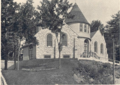
St. Timothy's Church, Roxborough is a parish of the Episcopal Diocese of Pennsylvania in the Roxborough neighborhood of Philadelphia, Pennsylvania, United States. It is part of the Wissahickon Deanery of the Diocese of Pennsylvania. In 1962, St. Timothy's reported membership of 1,144 and weekly attendance of 849, while its 2021 reported attendance was 27 persons.

St. David's Episcopal Church is a parish of the Episcopal Diocese of Pennsylvania in the Manayunk neighborhood of Philadelphia, Pennsylvania. It is part of the Wissahickon Deanery of the Diocese of Pennsylvania. In 1960, the parish reported 621 members; it reported 37 members in 2019. English-born mill-workers were heavily represented in its early population, while mill owners were successive wardens, vestrymen, and treasurers.

References

  1. Campbell, William Bucke (1942). "Old Towns and Districts of Philadelphia: An Address Delivered Before the City History Society of Philadelphia, February 26, 1941". Philadelphia History. 4 (5): 122 via Penn State University Libraries Digital Collections.
  2. 1 2 3 4 Philadelphia Historical Commission, staff (September 2019). "145 Sumac Street Nomination for Historic Designation Form" (PDF). City of Philadelphia – Philadelphia Historical Commission. Retrieved January 16, 2020.
  3. 1 2 3 4 Philadelphia Historical Commission, staff (September 2019). "147 Sumac Street Nomination for Historic Designation Form" (PDF). City of Philadelphia – Philadelphia Historical Commission. Retrieved January 16, 2020.
  4. Salisbury, Stephan (May 5, 2005). "100 Steps Zigzag in Right Direction". The Philadelphia Inquirer. pp. B.1. Retrieved February 21, 2016.
  5. Hahn, Ashley (April 14, 2017). "Historic Wissahickon house designated despite owner objection". WHYY Philadelphia. Retrieved January 19, 2020.
  6. 1 2 "Ridge Avenue Roxborough Thematic Historic District Inventory" (PDF). July 2018. Retrieved January 19, 2020.
  7. "Nine properties recommended for historic designation to finish 2016". WHYY. Retrieved July 8, 2022.
  8. "Philadelphia Register of Historic Places". City of Philadelphia (phila.gov). Retrieved July 8, 2022.
  9. "559 Righter Street Proposal" (PDF). City of Philadelphia (phila.gov). June–July 2022. Retrieved July 8, 2022.
  10. Allegretti, Jeffrey (January 20, 2015). "Nomination of Historic Building, Structure, Site, or Object (145 Sumac Street)" (PDF). City of Philadelphia, Historical Commission. Retrieved June 3, 2018.
  11. Jaffe, Alan (June 2, 2015). "Multi-pronged Battle Ahead for Group of Neighbors Trying to Save Historic Wissahickon House". PlanPhilly. Retrieved June 3, 2018.
  12. Jaffe, Alan (June 24, 2015). "Historic Recognition Won't Save Roxborough House from Demolition". PlanPhilly. Retrieved June 3, 2018.
  13. Jaffe, Alan (August 17, 2015). "Civic Group, Developer Reach Agreement about Future of Historic Wissahickon Property". PlanPhilly. Retrieved June 3, 2018.
  14. Lurye, Sharon (August 17, 2015). "Historic House in Manayunk Saved from Demolition". Philly Voice. Retrieved June 3, 2015.
  15. Romero, Melissa (July 29, 2016). "Wissahickon Queen Anne Home Undergoes Restoration, asks $499K". Curbed Philadelphia. Retrieved June 3, 2018.
  16. 1 2 Herr-Cardillo, Starr (November 11, 2019). "Legendary Jazz Landmark and Keystone Battery up for Historic Designation Consideration". Hidden City Philadelphia. Retrieved January 16, 2020.
  17. 1 2 Philadelphia Historical Commission, staff (July 9, 2018). "Ridge Avenue Roxborough Thematic Historic District Nomination" (PDF). Retrieved January 20, 2020.
  18. "Real Estate News". The Philadelphia Inquirer. September 2, 1897. p. 12.
  19. "Real Estate News". The Philadelphia Inquirer. April 28, 1896. p. 10.
  20. Kellogg, Isabelle (September 3, 2014). "Jacobs Wyper Architects Restores Merrick Hall at Northern Home for Children in Roxborough". American Institute of Architects Philadelphia Chapter. Retrieved February 21, 2016.
  21. Fox, Jessie (September 23, 2013). "Expanding Services By Merging Old And New At Roxborough's Northern Services". Hidden City Philadelphia. Retrieved February 21, 2016.
  22. "Northern Home for Friendless Children". Philadelphia Architects and Buildings. 2016. Retrieved February 21, 2016.
  23. Chastain, Sue (December 13, 1994). "A Roxborough Home For Boys Helps Them To Move Forward". The Philadelphia Inquirer. Retrieved February 21, 2016.
  24. Scally, Bernard J. (August 3, 2014). "Northern Children's Services offer more with Merrick Hall reopening". Roxborough Review. Retrieved February 21, 2016.
  25. "National Register Information System". National Register of Historic Places . National Park Service. July 9, 2010.
  26. 1 2 3 Manton, John Charles (1990). Bygones: A Guide to Historic Roxborough-Manayunk. Philadelphia: J.C. Manton. pp. 87–88. OCLC   21743508.
  27. 1 2 "St. Timothy Working Men's Club & Institute". Philadelphia Architects and Buildings. The Athenaeum of Philadelphia. 2018. Retrieved May 26, 2018.
  28. Merrick, J. Vaughan (1878). Workingmen's Clubs and Institutes: How to Organize and How to Conduct Them : an Address at the Opening of the New Building Erected for St. Timothy's Workingmen's Club and Institute, Roxborough, Philadelphia. Philadelphia. OCLC   77318739.{{cite book}}: CS1 maint: location missing publisher (link)
  29. Manton, John C. (1983). Victorian Roxborough: An Architectural History. J.C. Manton, Historical Research. pp. 22–25. OCLC   256225727.
  30. 1 2 mjk38 (August 11, 2014). "End of St. Timothy's Workingmen's Club and Institute in Roxborough (1913)". Philadelphia Studies. Retrieved July 14, 2016.{{cite web}}: CS1 maint: numeric names: authors list (link)
  31. "Paine Residence". Philadelphia Architects and Buildings. The Athenaeum of Philadelphia. 2018. Retrieved May 25, 2018.
  32. Moak, Jefferson M. (December 13, 2011). "City of Philadelphia, Records Department, City Archives, RG 149.6, Fairmount Park Commission Index to Briefs of Title of Fairmount Park Properties. (Finding Aid)". PACSCL Finding Aids. University of Pennsylvania Libraries. Retrieved May 25, 2018.
  33. Haller, John S. Jr. (1994). Medical Protestants: The Eclectics in American Medicine, 1825–1939. Carbondale: Southern Illinois University Press. ISBN   0585029660. OCLC   42854393.
  34. Alexander (1886). Wilder, Alexander (ed.). Transactions of the National Eclectic Medical Association of the United States of America for the Years 1885–86. Vol. 13. Orange. NJ: Chronicle Book and Job Printing Office.
  35. Paine, William (1870). Pennsylvania frauds! How state officials teach a political arithmetic! What Dr. Paine knows of the frauds of the Pennsylvania war claims. Internet Archive: [Philadelphia.
  36. "Alumni Personals". The Lafayette Weekly. May 26, 1899.
  37. "Wissahickon Presbyterian Church". Philadelphia Architects and Buildings. 2017.
  38. White, William P. (1895). The Presbyterian Church in Philadelphia. A Camera and Pen Sketch of Each Presbyterian Church and Institution in the City. Philadelphia: Allen, Lane & Scott. p. 213.
  39. 1 2 3 "2010 Census: Apportionment Data Map". United States Census Bureau. Retrieved May 27, 2018.
  40. "Cook-Wissahickon Elementary School". The School District of Philadelphia. Retrieved July 16, 2015.
  41. "Welcome". Cook-Wissahickon Elementary School. The School District of Philadelphia. Retrieved February 21, 2016.
  42. Edmunds, Franklin Davenport (February 12, 1914). "Wissahickon School". Free Library of Philadelphia Digital Collections. Retrieved November 24, 2017.
  43. "High School Directory Fall 2017 Admissions" (Archive). School District of Philadelphia. p. 57/70. Retrieved November 16, 2016.
  44. "Roxborough Branch." Free Library of Philadelphia . Retrieved November 7, 2008.
  45. Fourth Annual Message of John E. Reyburn Mayor of the City of Philadelphia with Annual Reports of Various Departments ..., Volume 1. Philadelphia, PA: Dunlap Printing Co. 1911. p. 1137. Retrieved February 20, 2016.
  46. "Wissahickon Branch: Interior view of the Wissahickon Branch, ca. 1909". Free Library of Philadelphia Digital Collections. 2016. Retrieved February 20, 2016.
  47. "Wissahickon Branch: Exterior view of the Wissahickon Branch, ca. 1909". Free Library of Philadelphia Digital Collections. 2016. Retrieved February 20, 2016.
  48. "FP.2010.001, Reference Collection (Finding Aid), Fairmount Park Historic Resource Archives". PACSCL Finding Aids. Retrieved July 13, 2016.
  49. Chakars, Janis (April 23, 2012). "Phil Moyer Keeps LaNoce Park Looking Good". Newsworks. Retrieved July 13, 2016.
  50. "Wissahickon Barber Shop Celebrates 100 years". WHYY. Retrieved June 3, 2018.
  51. "Philadelphia Parks & Recreation Finder – Wissahickon Valley Park". Philadelphia Parks & Recreation. Retrieved April 17, 2021.
  52. 1 2 "FAQ". Friends of Wissahickon. Retrieved April 17, 2021.
  53. Cooperman, Emily T. (2008). "Historic Context Statement for Neighborhod Cluster 2: Roxborough and Manayunk" (PDF). Preservation Alliance for Greater Philadelphia. Retrieved April 17, 2021.
  54. Thomas, George E. (2012). "Frank Furness: Philadelphia & Reading Railroad". FrankFurness.org. Retrieved February 20, 2016.
  55. Pasquarello, Daniel (January 2, 2015). "Proposed Wissahickon mural aims to show local balance between urban and natural environments". WHYY/NewsWorks. Retrieved February 20, 2016.
  56. Muse, Queen (April 20, 2015). "Community begins to brainstorm for upcoming mural at the Wissahickon station". WHYY/NewsWorks. Retrieved February 20, 2016.
  57. Corrigan, John (August 5, 2015). "Plans for Wissahickon Station mural revealed". WHYY/NewsWorks. Retrieved February 20, 2016.
  58. "Mural Begins to Unfold in Wissahickon". Town News Today. June 14, 2016. Retrieved July 13, 2016.
  59. Philadelphia City Planning Commission (July 23, 2018). "Wissahickon Gateway Plan is Complete!". Philadelphia2035. Retrieved April 17, 2021.
  60. Saffron, Inga (October 27, 2020). "SEPTA's new Wissahickon bus station promises better connections. But it could harm a beloved Philly landscape". Philadelphia Inquirer. Retrieved April 17, 2021.
  61. "SEPTA plans hearing on Wissahickon center". The (Roxborough) Review – Montgomery News. February 25, 2020. Retrieved April 17, 2021.
  62. LeStourgeon, Colin (September 27, 2020). "Renderings Released for Wissahickon Transportation Center Renovation". Philadelphia YIMBY. Retrieved April 17, 2021.
  63. Stuart, Sarah Clark (July 22, 2020). "Groups Call For Action on the Wissahickon Gateway Trail". Bicycle Coalition of Greater Philadelphia. Retrieved April 17, 2021.
  64. Scally, Bernard J. (June 16, 2015). "Civics look into ways to guide change; Wissahickon Interested Citizens Association seeks remapped zoning ordinance". Roxborough Review. Retrieved January 19, 2020.
  65. Saffron, Inga (January 14, 2016). "Changing Skyline: Fighting the suburbanizing tide in Roxborough". The Philadelphia Inquirer. Retrieved January 19, 2020.
  66. Corrigan, John (March 7, 2016). "Wissahickon looks to rezone neighborhood to boost preservation efforts". WHYY Philadelphia. Retrieved January 19, 2020.
  67. Fitzsimmons, Eric (March 10, 2016). "Rezoning plan presented to Wissahickon community". Roxborough Review. Retrieved January 19, 2020.
  68. Blumgart, Jake (May 21, 2018). "New development controls proposed for a hidden gem of the Northwest". WHYY Philadelphia. Retrieved January 19, 2020.
  69. "American Legal Publishing – Online Library". library.amlegal.com. Retrieved January 19, 2020.

Further reading

Historic maps of the area