Schuylkill River Trail

Last updated

Schuylkill River Trail
Schuylkill River Trail 2018.jpg
The trail runs along the Schuylkill River in Philadelphia, near the Philadelphia Museum of Art
Location
Use Multi-use trail
SeasonAll
Sights
Surface
  • Paved
  • Crushed stone
  • Wooden boardwalk
  • On-road
Maintained by
  • Schuylkill River Development Corp.
  • Montgomery County
  • Chester County
  • Schuylkill River Greenway Assn.
Website schuylkillriver.org/schuylkill-river-trail/

The Schuylkill River Trail ( /ˈsklkɪl/ SKOOL-kil, [1] locally /-kəl/ ) [2] is a multi-use trail along the banks of the Schuylkill River in southeastern Pennsylvania. Partially complete as of 2018, the trail is ultimately planned to run about 140 miles (230 km) from the river's headwaters in Schuylkill County to Fort Mifflin in Philadelphia.

Contents

Completed portions of the trail include a section from Auburn to Hamburg, a 19.5-mile (31.4 km) portion from Reading to Pottstown, and a 23.2-mile (37.3 km) portion from Oaks to South Street in Center City Philadelphia. [3]

Large stretches of the trail are rail trails. Parts of it belong to the East Coast Greenway, a 3,000-mile trail system connecting Maine to Florida.

On many maps and street atlases, and on some of the trail's signage, the segment between Philadelphia and Valley Forge is still identified by the older name Philadelphia–Valley Forge Trail. [4]

Trail description

Auburn to Pottstown

Schuylkill River Trail at the Pottstown Riverfront Park Pottstown Riverfront Park, April 2016.jpg
Schuylkill River Trail at the Pottstown Riverfront Park

The Schuylkill River Trail begins at a trailhead at the Kernsville Dam in Auburn just above Hamburg. [3] The trail runs through Reading to Pottstown until it reaches the Riverfront Park on College Drive near the Reading Railroad Pottstown Station. This section passes through the Schuylkill River National and State Heritage Area, an area generally known for recreational fishing. [5]

In lower Berks County, the trail follows the existing Thun Trail, named for industrialist Ferdinand Thun, who founded the Textile Machine Works in Reading in 1892 (later moved to the borough of Wyomissing, a suburb of Reading, in 1896). [6] [7] Plans are underway for a connection from Reading, north to Hamburg. The current northern edge links the trail with the Union Canal towpath.

The trail begins in North Reading, along Riverview Drive, then quickly crosses an old railroad bridge into West Reading. It then continues as a mixed-surface path of macadam, gravel, coarse stone, and chalk to Gibraltar where it becomes a poorly marked on-road bicycle route following Old River Road and Schuylkill Road to Birdsboro. From there, the trail follows the old concrete industrial collector, Armorcast Road, to the rear entrance of a ballfield. The trail then goes off-road as a gravel path to the county line where it meets the paved Schuylkill River Trail, which currently terminates in Pottstown.

Pottstown to Phoenixville / Mont Clare

Trail at mile 23 marker Schuylkill River Trail mile 23 marker.jpg
Trail at mile 23 marker

Two routes have been proposed for this stretch. One would come down the right bank (Chester County side) and end near Cromby Generating Station, above Phoenixville, then use borough streets and the Mont Clare Bridge (PA29) to connect with the trail section along the Canal in Mont Clare. The other plan would bring the trail down the left bank to Mont Clare. It appears that both options may eventually be built, with the Chester County trail proceeding first and carrying the main SRT designation.

In April 2011, the Spring City-to-Cromby segment opened on the Chester County side. This segment includes a new trailhead on Township Line Road, near the Cromby Power Plant.

Until 2020, there was a disconnect in the official SRT between Phoenixville and Mont Clare, although foot and bicycle traffic easily used the Mont Clare Bridge sidewalk to connect. In 2019-2020 the sidewalk was replaced with a 10 foot wide, barrier protected trail segment, officially closing the gap.

Mont Clare to Oaks

The trail in Montgomery County next to U.S. Route 422 US 422 Schuylkill River Trail 2.jpg
The trail in Montgomery County next to U.S. Route 422

The stretch of trail from Mont Clare to the Perkiomen Creek near Oaks opened in the spring of 2008. In the first phase of construction the southern section of the trail between Longford Road at the present watered end of the Oakes Reach of the Schuylkill Canal and the Oaks intersection with the Perkiomen Trail was constructed. This section follows much of the filled portion of the Oakes Reach and is paved except for a gravel segment of about half a mile (which also includes a short trail detour). To cross the three streams in this section, two new culverts were constructed and the trail temporarily routed over a historical aqueduct from the Canal at Crossman's Run. A new bridge was built across Crossman's Run for the trail and the paving was completed.

The historic Schuylkill Canal aqueduct carries the trail over Crossman's Run near Oaks Schuylkill Canal Oaks Viaduct, January 2008.jpg
The historic Schuylkill Canal aqueduct carries the trail over Crossman's Run near Oaks

For phase 1, the northern section, upstream of Longford Road, is signed along the low volume Port Providence Road and Walnut Street, which run along the left bank of the Canal, to reach Mont Clare. In a second phase of construction for the northern segment, the Canal towpath on the canal right bank will be refurbished, and a small bridge constructed over a spillway near Port Providence. On February 14, 2008, a meeting was held to announce the survey work for the Phase 2 extension. This would provide an off-road alternative between Longford Road and Mont Clare. It was expected that the towpath restoration itself would commence in the fall of 2010, [8] but Montgomery County put the project on hold due to budget constraints. In early 2013, construction was started on the towpath portion of the trail with improvements to the Route 29 underpass and construction of a new spillway and foot bridge opposite Port Providence.

Oaks to Philadelphia

The trail through downtown Conshohocken Schuylkill River Trail in Conshohocken.JPG
The trail through downtown Conshohocken

The next segment of the trail begins in Oaks at the southern end of the Perkiomen Trail and a trailhead at Pawlings Road. This paved segment runs along the abandoned trackbed of the former Schuylkill Branch of the Pennsylvania Railroad. It runs beside U.S. Route 422 for a short distance, then runs through Valley Forge National Historical Park. After leaving the park at Betzwood, it continues along the river to Norristown, where it crosses over U.S. Route 202 and runs through the middle of the Norristown Transportation Center.

The trail continues eastwards, now parallel to the SEPTA Manayunk/Norristown rail line. On entering Conshohocken, it passes through industrial areas, under Interstate 476, and intersects the local Cross County Trail.

Philadelphia

Trail Entering Philadelphia Schuylkill River Trail Entering Philadelphia.jpg
Trail Entering Philadelphia
The Schuylkill River Trail in Schuylkill Banks park, Philadelphia Schuylkill River Trail (Philadelphia).JPG
The Schuylkill River Trail in Schuylkill Banks park, Philadelphia

Shortly after crossing into Philadelphia, trail traffic is briefly directed onto Nixon and Shawmont Streets, crossing the SEPTA Manayunk/Norristown Line's tracks at the decommissioned Shawmont station.

The trail continues southeastward, unpaved, along the former Manayunk Canal Towpath [9] of the Schuylkill Navigation System, passing through the neighborhood of Manayunk to the end of the towpath at Lock Street. Trail traffic is then directed onto the street or sidewalks of Main Street and Ridge Avenue toward Fairmount Park, where the trail meets the southern end of the Wissahickon Trail. Trail traffic continues on the road or sidewalk over the historic Ridge Avenue Bridge (NRHP) crossing the Wissahickon Creek, and turning right onto the paved multi-use trail beside Kelly Drive through east Fairmount Park.

The boardwalk over the river in Schuylkill Banks park Philadelphia cityscape BW 20150328.jpg
The boardwalk over the river in Schuylkill Banks park

The trail then winds along the east bank of the Schuylkill River through the park, first passing by the Falls Bridge, then passing under many railroad and highway bridges, past several monuments and Laurel Hill Cemetery. It runs beside the Ellen Phillips Samuel Memorial and Boathouse Row before following the Azalea Garden behind the Philadelphia Museum of Art and next to the Fairmount Water Works. After passing under the Spring Garden Street Bridge and West River Drive Bridge, the trail runs along the riverbank on the west edge of Center City, Philadelphia as a waterfront park named Schuylkill Banks. [10] At Locust Street the trail splits with a bridge carrying the trail over CSX-owned railroad tracks to terminate in Schuylkill River Park, [11] while a 2,000 ft (610 m) boardwalk opened in 2014 [12] extends over the river and continues to South Street, ending at the south side of the South Street Bridge. [13] The bridge deck is reached by a ramp to the north side of the bridge or by a staircase with a bike trough up to the south side of the bridge.

On May 20, 2009, as one of its last acts, the Fairmount Park Commission approved the acquisition of 12 acres (49,000 m2) of land along the Schuylkill River to extend the river trail. [14]

From South Street to Christian Street, the trail continues over land owned by Children's Hospital of Philadelphia, which announced plans to host the trail in 2013 [15] and opened the section on April 20, 2018. [16]

The next extension of the river trail includes a proposed cable-stayed bridge to connect Christian Street to the existing trail in Grays Ferry Crescent, a park along the Grays Ferry river bend. [17] This trail section received $12,000,000 from the U.S. Department of Transportation in March 2018. [18] Construction on this trail portion is scheduled to begin in 2020. [19] A related project involves the conversion of an abandoned railway swing bridge to a pedestrian and cyclist swing bridge connecting Grays Ferry Crescent to Bartram's Mile—a park on the west side of the Schuylkill River, north of Bartram's Garden. [20] [21] The bridge is under construction south of the Grays Ferry Bridge, with funding from the city, state, and a Federal Highway Administration program. [22] Completion of the bridge conversion is expected in spring 2024. [23]

History

Schuylkill River Trail eastbound at Spring Mill Schuylkill River Trail EB at Spring Mill.jpeg
Schuylkill River Trail eastbound at Spring Mill

Many current and proposed sections of the Schuylkill River Trail, including the Thun Trail and the Oaks to Philadelphia portion, are rail trails, following the right-of-way of the former Schuylkill Branch of the Pennsylvania Railroad. Live catenary wires are still in place above the trail between Norristown and Philadelphia. These are part of Amtrak's 25 Hz traction power system, and supply power for both the Philadelphia to Harrisburg Main Line and Northeast Corridor.

The Shawmont to Manayunk portion of the trail runs along the towpath of the historic Schuylkill Canal (Schuylkill Navigation System).

See also

Related Research Articles

<span class="mw-page-title-main">Upper Providence Township, Montgomery County, Pennsylvania</span> Township in Pennsylvania, United States

Upper Providence Township is a township in Montgomery County, Pennsylvania, United States. As of the 2010 census, the township population was 21,219.

<span class="mw-page-title-main">Roxborough, Philadelphia</span> Neighborhood in Philadelphia, Pennsylvania, United States

Roxborough is a neighborhood in the Northwest section of the city of Philadelphia, Pennsylvania, United States. It is bordered to the southwest, along the Schuylkill River, by the neighborhood of Manayunk, along the northeast by the Wissahickon Creek section of Fairmount Park, and to the southeast by the neighborhood of East Falls. Beyond Roxborough to the northwest is Montgomery County. Roxborough's ZIP code is 19128. Most of Roxborough is in Philadelphia's 21st Ward.

<span class="mw-page-title-main">Schuylkill River</span> River in eastern Pennsylvania, United States

The Schuylkill River is a river running northwest to southeast in eastern Pennsylvania. The river was improved by navigations into the Schuylkill Canal, and several of its tributaries drain major parts of Pennsylvania's Coal Region. It flows for 135 miles (217 km) from Pottsville to Philadelphia, where it joins the Delaware River as one of its largest tributaries.

<span class="mw-page-title-main">Manayunk, Philadelphia</span> Neighborhood of Philadelphia in Pennsylvania, United States

Manayunk is a neighborhood in the section of Lower Northwest Philadelphia in the state of Pennsylvania. Located adjacent to the neighborhoods of Roxborough and Wissahickon and also on the banks of the Schuylkill River, Manayunk contains the first canal begun in the United States.

<span class="mw-page-title-main">Schuylkill Expressway</span> Highway in Pennsylvania

The Schuylkill Expressway, locally known as "the Schuylkill", is a freeway through southern Montgomery County and the city of Philadelphia. It is the easternmost segment of Interstate 76 (I-76) in the U.S. state of Pennsylvania. It extends from the Valley Forge interchange of the Pennsylvania Turnpike in King of Prussia, paralleling its namesake Schuylkill River for most of the route, southeast to the Walt Whitman Bridge over the Delaware River in South Philadelphia. It serves as the primary corridor into Philadelphia from points west. Maintenance and planning for most of the highway are administered through Pennsylvania Department of Transportation (PennDOT) District 6, with the Delaware River Port Authority (DRPA) maintaining the approach to the Walt Whitman Bridge.

<span class="mw-page-title-main">Norristown Transportation Center</span> Passenger transportation hub in Norristown, Pennsylvania

Norristown Transportation Center is a two-level multimodal public transportation regional hub located in Norristown, Pennsylvania and operated by SEPTA. It opened in 1989, replacing the older Norristown High Speed Line terminus one block away at Main and Swede Streets, and integrated the former Reading Company's DeKalb Street Norristown railroad station into its structure. A plaque embedded in the sidewalk between the bus lane and Lafayette Street commemorates the location of one of the columns of the dismantled segment of the Philadelphia and Western Railroad (P&W) trestle.

Schuylkill River Passenger Rail is a proposed passenger train service along the Schuylkill River between Philadelphia and Reading, Pennsylvania, with intermediate stops in Norristown, King of Prussia, Phoenixville, and Pottstown.

<span class="mw-page-title-main">Schuylkill Canal</span>

The Schuylkill Canal, or Schuylkill Navigation, was a system of interconnected canals and slack-water pools along the Schuylkill River in the U.S. state of Pennsylvania, built as a commercial waterway in the early 19th-century. Chartered in 1815, the navigation opened in 1825 to provide transportation and water power. At the time, the river was the least expensive and most efficient method of transporting bulk cargo, and the eastern seaboard cities of the U.S. were experiencing an energy crisis due to deforestation. It fostered the mining of anthracite coal as the major source of industry between Pottsville and eastern markets. Along the tow-paths, mules pulled barges of coal from Port Carbon through the water gaps to Pottsville; locally to the port and markets of Philadelphia; and some then by ship or through additional New Jersey waterways, to New York City markets.

<span class="mw-page-title-main">East Falls, Philadelphia</span> Neighborhood of Philadelphia in Philadelphia County, Pennsylvania, United States

East Falls is a neighborhood in Lower Northwest, Philadelphia, Pennsylvania, United States. It lies on the east bank of the "Falls of the Schuylkill," cataracts submerged in 1822 by the Schuylkill Canal and Fairmount Water Works projects. East Falls sits next to the Germantown, Roxborough, Allegheny West, and Nicetown-Tioga neighborhoods. Wissahickon Valley Park separates it from Manayunk, Philadelphia.

<span class="mw-page-title-main">U.S. Route 422</span> Highway in Ohio and Pennsylvania

U.S. Route 422 (US 422) is a 271-mile (436 km) long spur route of US 22 split into two segments in the U.S. states of Ohio and Pennsylvania. The western segment of US 422 runs from downtown Cleveland, Ohio, east to Ebensburg, Pennsylvania. The eastern segment, located entirely within Pennsylvania, runs from Hershey east to King of Prussia, near Philadelphia. US 422 Business serves as a business route into each of four towns along the way.

<span class="mw-page-title-main">Mont Clare, Pennsylvania</span> Village in Pennsylvania, United States

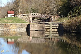
Mont Clare is a village in Upper Providence Township, Montgomery County, Pennsylvania. The village is located on the left bank of the Schuylkill River opposite Phoenixville and Chester County. Mont Clare is at the site of the former Jacobs' ford. Mont Clare hosts the only functional lock and one of only two remaining watered stretches of the Schuylkill Canal. Mont Clare was the birthplace of the infamous outlaw Sundance Kid.

<span class="mw-page-title-main">Schuylkill Branch</span> Former railroad line in Pennsylvania

The Schuylkill Branch was a rail line owned and operated by the former Pennsylvania Railroad (PRR) in the U.S. state of Pennsylvania. The line ran from the Philadelphia to Harrisburg Main Line at 52nd Street in Philadelphia north via Norristown, Reading, and Pottsville to Delano Junction. From Delano Junction, the PRR had trackage rights over the Lehigh Valley Railroad's Hazleton Branch and Tomhicken Branch to Tomhicken, where the PRR's Catawissa Branch began. In conjunction with the Catawissa Branch, Nescopeck Branch, and Wilkes-Barre Branch, the Schuylkill Branch gave the PRR a direct line from Philadelphia to Wilkes-Barre.

<span class="mw-page-title-main">U.S. Route 202 in Pennsylvania</span> US Highway in Pennsylvania

U.S. Route 202 is a US Highway running from New Castle, Delaware, northeast to Bangor, Maine. The route runs through the southeastern part of the U.S. state of Pennsylvania, passing through the western and northern suburbs of Philadelphia in the Delaware Valley metropolitan area. US 202 serves largely as a toll-free bypass around the city, avoiding the busy traffic and congestion on Interstate 95 (I-95). It is signed north–south and follows a general southwest–northeast direction through the state, serving West Chester, King of Prussia, Bridgeport, Norristown, Montgomeryville, Doylestown, and New Hope. US 202 enters Pennsylvania from Delaware and heads north as a divided highway, where it becomes concurrent with US 322 at an intersection with US 1 in Painters Crossing. The two routes run north and become a freeway that bypasses West Chester to the east, with US 322 splitting from US 202. US 202 continues north and east along the freeway to King of Prussia, where it reverts to an at-grade divided highway following an interchange with I-76. The route becomes a one-way pair as it passes through Bridgeport and Norristown before both directions rejoin and the road continues northeast. US 202 follows an expressway-grade parkway between Montgomeryville and Doylestown prior to bypassing Doylestown to the south along a freeway. The route continues northeast as an at-grade road to New Hope, where it turns into a freeway again before it crosses the Delaware River on the New Hope–Lambertville Toll Bridge into New Jersey.

<span class="mw-page-title-main">Mont Clare Bridge</span> Bridge in Southeastern Pennsylvania, USA

The Mont Clare Bridge is a crossing of the Schuylkill River between Mont Clare and Phoenixville in Pennsylvania, USA. The bridge was also referred to as the Intercounty Bridge, as it connects Montgomery and Chester counties. The bridge abuts a shorter county bridge across the Schuylkill Canal and towpath on the Mont Clare side to complete the crossing. The crossing carries Bridge Street and the Schuylkill River Trail.

<span class="mw-page-title-main">Schuylkill Canal Association</span>

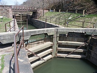
The Schuylkill Canal Association (SCA) is a non-governmental organization that maintains the Oakes Reach and Lock #60 of the Schuylkill Canal as a public recreation area and historical site. Organized in 1982 as the Schuylkill Canal Advisory Board, the Association, in cooperation with Upper Providence Township, Montgomery County, and the Commonwealth of Pennsylvania, maintains the canal reach, associated structures, parks and trails. The area extends along the canal and left bank of the Schuylkill River, from Mont Clare past Port Providence. The area makes up a large part of the Schuylkill Navigation Canal, Oakes Reach Section Historic District (#88000462).

<span class="mw-page-title-main">Manayunk/Norristown Line</span> SEPTA Regional Rail line

The Manayunk/Norristown Line is a commuter rail service in Southeastern Pennsylvania between Center City Philadelphia and Norristown, and one of the 13 lines in SEPTA's Regional Rail network. It has the fourth highest ridership and the highest operating ratio (58%) on the SEPTA Regional Rail network.

The Manayunk Expressway was a proposed parkway that was to run along the east bank of the Schuylkill River similar to the Moses parkways of New York City, first proposed in 1932 by the Regional Planning Federation. It was originally designed to connect Fairmount Park in Philadelphia with Norristown. The purpose was to have served as an alternate route to the Schuylkill Expressway and Germantown Pike that by 1960 had become congested.

<span class="mw-page-title-main">Manayunk Canal Towpath</span>

The Manayunk Canal Towpath is a trail that runs along the Schuylkill River Canal in Manayunk, Pennsylvania, a northwest section of Philadelphia. The Towpath parallels the Manayunk Canal and the Schuylkill River. The canal was dug in 1819. The Towpath is accessible from Fairmount Park to the East and from the Schuylkill River Trail to the West. As the Towpath runs through heavy industry and rural-like settings, its surface varies between boardwalk, gravel, and pavement. This makes the Towpath ideal for running, walking, and cycling. Fishing in the Schuylkill Canal along the Manayunk Towpath is a favorite past time for visitors and residents alike. Visible along the Towpath are rail lines, old canal locks, ruins of the lock tender's house and old textile mills. Plentiful wildlife thrives along the Manayunk Canal Towpath including many species of birds, fish, turtles, and native plants. The Manayunk Development Corporation is currently organizing a full restoration of the Manayunk Canal; once the restoration is complete, it will be possible for canoes and small boats to sail through the Manayunk Canal Towpath as they make their way down the Schuylkill River.

<span class="mw-page-title-main">Norristown Branch</span>

The Norristown Branch is a railway line in Pennsylvania. It runs 14.6 miles (23.5 km) from a junction with the SEPTA Main Line in North Philadelphia to Norristown, Pennsylvania. It was originally built by the Philadelphia, Germantown and Norristown Railroad (PG&N) in 1834, and was a part of the Reading Company system from 1870 until 1976. Today it is owned by SEPTA and hosts the Manayunk/Norristown Line commuter rail service.

Ridge Pike is a major historic road in the U.S. state of Pennsylvania that opened in 1706 that originally connected Wissahickon Creek to Perkiomen Creek. Inside Philadelphia, it is called Ridge Avenue. Going westward, it traverses many eastern Pennsylvania neighborhoods in Montgomery County including Conshohocken and beyond, connecting with Germantown Pike near Collegeville and continuing to Pottstown. In Montgomery County, Ridge Pike is called Main Street in the Norristown area and again in Collegeville and Trappe, and is called High Street in the Pottstown area.

References

  1. Oxford Dictionary: definition of Schuylkill River (American English)
  2. "Definition of SCHUYLKILL". www.merriam-webster.com.
  3. 1 2 "first_map_paths" (PDF). Retrieved July 26, 2009.
  4. ADC Map (2001). Street Map Book, Montgomery County, Pennsylvania (16th ed.). Alexandria, VA, USA: ADC Map. pp. Map 35 (p. 39), Map 36 (p. 40). ISBN   0-87530-083-9.
  5. "Top Spots To Go Fishing In Philadelphia".
  6. "The Berkshire – Reading Eagle Newspaper". Readingeagle.com. Retrieved July 26, 2009.
  7. "Historical Society of Berks County PA / Berkshire Knitting Mill". Berkshistory.org. July 6, 1906. Retrieved July 26, 2009.
  8. "Canal Towpath Restoration Project – Summary of Meeting Minutes – Design Phase Meeting #27 – May 6, 2010" (PDF). Archived from the original (PDF) on July 23, 2011. Retrieved May 22, 2010.
  9. Archived June 22, 2006, at the Wayback Machine
  10. "Schuylkill Banks FAQs". schuylkillbanks.org. Schuylkill River Development Corporation. n.d. Archived from the original on December 30, 2016. Retrieved December 30, 2016.
  11. "Friends of Schuylkill River Park". Fsrp.org. n.d. Retrieved July 26, 2009.
  12. "Philadelphia cuts ribbon on new boardwalk".
  13. "Schuylkill Banks trail map". schuylkillbanks.org. Schuylkill River Development Corporation. n.d. Archived from the original on December 30, 2016. Retrieved December 30, 2016.
  14. Von, Jane M. (n.d.). "Fairmount Park Commission OKs acquisition of Schuylkill land parcels|Philadelphia Inquirer|05/21/2009:". Philly.com. Archived from the original on May 27, 2009. Retrieved July 26, 2009.
  15. "Schuylkill Avenue Master Plan" (PDF). chop.edu. Children's Hospital of Philadelphia. May 7, 2013. p. 1. Archived from the original (PDF) on March 29, 2014. Retrieved December 30, 2016. CHOP and the Schuylkill River Development Corporation have formalized an easement to extend the Schuylkill River Trail south of the South Street Bridge almost to Catherine Street...walkway to extend the Trail to Christian Street.
  16. "South to Christian Dedication Ceremony". schuylkillbanks.org. Schuylkill River Development Corporation. n.d. Retrieved May 10, 2018.
  17. Fike, Lane B. (April 13, 2018). "Capital Projects Update". schuylkillbanks.org. Schuylkill River Development Corporation. Retrieved May 10, 2018.
  18. "Christian to Crescent Receives $12M in Federal Funding". schuylkillbanks.org. Schuylkill River Development Corporation. March 9, 2018. Retrieved May 10, 2018.
  19. "Christian to Crescent". schuylkillbanks.org. Schuylkill River Development Corporation. n.d. Retrieved May 10, 2018.
  20. "Conrail Donates Swing Bridge for the Schuylkill Crossing". schuylkillbanks.org. Schuylkill River Development Corporation. November 13, 2017. Retrieved May 10, 2018.
  21. "Bartram's Mile is Open!". schuylkillbanks.org. Schuylkill River Development Corporation. May 15, 2017. Retrieved May 11, 2018.
  22. "Schuylkill Crossing". schuylkillbanks.org. Schuylkill River Development Corporation. n.d. Retrieved May 10, 2018.
  23. "Schuylkill Crossing". Schuylkill Banks. July 21, 2016. Retrieved May 3, 2023.