Related Research Articles

Schuylkill County is a county in the Commonwealth of Pennsylvania. It is located in the heart of Pennsylvania's Coal Region and is part of Northeastern Pennsylvania. As of the 2020 census, the population was 143,049. The county seat is Pottsville.

Green Oak Charter Township is a charter township of Livingston County in the U.S. state of Michigan. As of the 2020 census, the township population was 19,539. In September 2005, the township board voted to incorporate as a charter township, becoming the second charter township in Livingston County.

Conshohocken is a borough on the Schuylkill River in Montgomery County, Pennsylvania in suburban Philadelphia. Historically a large mill town and industrial and manufacturing center, after the decline of industry in recent years Conshohocken has developed into a center of riverfront commercial and residential development. In the regional slang, it is sometimes referred to by the colloquial nickname Conshy.

Stowe is a census-designated place (CDP) in Montgomery County, Pennsylvania, United States. The population was 3,695 at the 2010 census. It uses the Pottstown ZIP code of 19464.

Upper Providence Township is a township in Montgomery County, Pennsylvania, United States. As of the 2010 census, the township population was 21,219.

Tulpehocken Creek is a 39.5-mile-long (63.6 km) tributary of the Schuylkill River in southeastern Pennsylvania in the United States, and during the American Canal Age, once provided nearly half the length of the Union Canal linking the port of Philadelphia, the largest American city and the other communities of Delaware Valley with the Susquehanna basin and the Pennsylvania Canal System connecting the Eastern seaboard to Lake Erie and the new settlements of the Northwest Territory via the Allegheny}, Monongahela. and Ohio Rivers at Pittsburgh.
The Schuylkill Canal, or Schuylkill Navigation, was a system of interconnected canals and slack-water pools along the Schuylkill River in the U.S. state of Pennsylvania, built as a commercial waterway in the early 19th-century. Chartered in 1815, the navigation opened in 1825 to provide transportation and water power. At the time, the river was the least expensive and most efficient method of transporting bulk cargo, and the eastern seaboard cities of the U.S. were experiencing an energy crisis due to deforestation. It fostered the mining of anthracite coal as the major source of industry between Pottsville and eastern markets. Along the tow-paths, mules pulled barges of coal from Port Carbon through the water gaps to Pottsville; locally to the port and markets of Philadelphia; and some then by ship or through additional New Jersey waterways, to New York City markets.
Fitzwater Station was a stop on the anti-slavery Underground Railroad. Located in Port Providence, Pennsylvania, United States, it is now a restaurant and bar. "The Fitz" overlooks the Schuylkill Canal.
Perkiomen Creek is a 37.7-mile-long (60.7 km) tributary of the Schuylkill River in Berks, Lehigh and Montgomery counties, Pennsylvania. The water course was also named Perquaminck Creek, on Thomas Holme's 1687 map.

The Schuylkill River Trail is a multi-use trail along the banks of the Schuylkill River in southeastern Pennsylvania. Partially complete as of 2018, the trail is ultimately planned to run about 140 miles (230 km) from the river's headwaters in Schuylkill County to Fort Mifflin in Philadelphia.
Manatawny Creek is an 18.2-mile-long (29.3 km) tributary of the Schuylkill River in Pennsylvania in the United States.
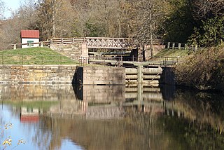
Mont Clare is a village in Upper Providence Township, Montgomery County, Pennsylvania. The village is located on the left bank of the Schuylkill River opposite Phoenixville and Chester Copunty. Mont Clare is at the site of the former Jacobs' ford. Mont Clare hosts the only functional lock and one of only two remaining watered stretches of the Schuylkill Canal. Mont Clare was the birthplace of the infamous outlaw Sundance Kid.

Early in the 19th century, the Leiper Canal built in 1828–29 during the middle of the American canal age ran about 3 miles (5 km) along Crum Creek in Delaware County to its mouth in Eastern Pennsylvania's Delaware Valley carrying its owner‘s quarried products to docks on the Delaware River tidewater until 1852.
Linfield is an unincorporated village, part of Limerick Township in Montgomery County, Pennsylvania. It is located approximately 35 miles northwest of Philadelphia, along the Schuylkill River.
Port Indian is a small, private boating community located in West Norriton Township, Montgomery County, Pennsylvania, United States.

Mill Creek is a 6.6-mile-long (10.6 km) tributary of the Schuylkill River in Lower Merion Township, Montgomery County, Pennsylvania, United States.

Kennedy Mansion , also known as Kennedy-Supplee Mansion, is an Italian-villa-style residence within Valley Forge National Historical Park. Now squeezed between PA Route 23 and U.S. Route 422, it once overlooked the 19th-century industrial village of Port Kennedy.

Geryville is a village located mainly in Milford Township, Bucks County but also in Upper Hanover Township, Montgomery County, Pennsylvania, United States. The first letter of the name is pronounced as a hard "g." It is located just north of Route 663 and is split between the East Greenville zip code of 18041 and the Pennsburg zip code of 18073. Originally known as Aurora, the village received its name from the postmaster Jesse Gery in 1865. The Publick House on the corner of Sleepy Hollow Road and Geryville Pike played a prominent role in Fries's Rebellion of 1799. It is drained via the Macoby Creek southward into the Perkiomen Creek and Schuylkill River.
The Manor of Gilberts was one of the areas of land that William Penn set aside for himself as the Proprietor of the Province of Pennsylvania. The Manor was located on the along the left (northeastern) bank of the Schuylkill River, extending above and below the Perkiomen Creek. The Manor was created on 8 October 1683 when Penn wrote a warrant assigning the Manor to himself. The tract was named after his paternal grandmother Joanne (Gilbert) Penn's family.
Mingo is an unincorporated village in Upper Providence Township, Montgomery County, Pennsylvania, United States, just southeast of Royersford close to the Schuylkill River.
References
- ↑ "Who was Christian C. Sanderson?". Archived from the original on 3 October 2011. Retrieved 30 September 2011.
