
Marlborough Township is a township in Montgomery County, Pennsylvania, United States. The population was 3,178 at the 2010 census.

Perkiomen Township is a township in Montgomery County, Pennsylvania, United States. As of the 2010 census, the township population was 9,139, which represents a 28.8% increase from the 2000 total of 7,093 residents. Governmentally, it is a township of the second class, governed by a board of supervisors. It is part of the Perkiomen Valley School District. Perkiomen Township includes an abundance of history that goes as far back as to the first tribes who inhabited the area. This township started with the inhabitants of the Lenni-Lenape Tribe and progressed in many ways into what it is today.
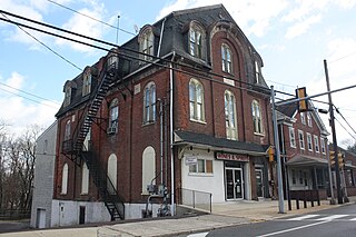
Schwenksville is a borough in Montgomery County, Pennsylvania, United States. The population was 1,431 at the 2020 census. It is notable for being located near the site of the Philadelphia Folk Festival. The borough was founded in 1684, when the Lenni-Lenape Indians ceded to William Penn the land along the Perkiomen Creek; it was incorporated in 1903. The borough was named for George Schwenk, whose son, Jacob Schwenk, served in George Washington's army.

Upper Providence Township is a township in Montgomery County, Pennsylvania, United States. As of the 2010 census, the township population was 21,219.
Hereford is a census-designated place that is located in Hereford Township, Berks County, Pennsylvania, United States.
Graterford is an unincorporated community in Perkiomen Township, Montgomery County, Pennsylvania, United States.
Unami Creek is a 16.5-mile-long (26.6 km) tributary of Perkiomen Creek in Lehigh, Bucks, and Montgomery counties in eastern and southeastern Pennsylvania.
Oaks is an unincorporated community located in Upper Providence Township, Montgomery County, Pennsylvania, United States. The community is 18 miles (30 km) northwest of Philadelphia and its boundaries are defined in large part by the village's position at the junction of Perkiomen Creek and the Schuylkill River.
Zieglerville is an unincorporated community in Lower Frederick Township in Montgomery County, Pennsylvania, United States. Its ZIP Code is 19492 and it is located on the west side of the Perkiomen Creek where PA Route 29 and PA Route 73 split at a roundabout, just north of Schwenksville.
Barto is an unincorporated community situated between the boroughs of Bally and Bechtelsville in Washington Township, Berks County, Pennsylvania, United States. Barto is part of the Delaware Valley, located near the border with Montgomery County. Its zip code is 19504 and the West Branch Perkiomen Creek flows southeast through it to join the Perkiomen Creek in the Green Lane Reservoir.

Palm is an unincorporated community in Montgomery County, Pennsylvania, United States. It lies along Pennsylvania Route 29 between Hereford and East Greenville at latitude 40.4281539 longitude −75.5329608. It is located in Upper Hanover Township and the ZIP Code is 18070.

Arcola is an unincorporated community in Upper Providence Township, Montgomery County, Pennsylvania. It is located on Perkiomen Creek, 6.5 miles (10.5 km) west-northwest of Norristown.
Perkiomen may refer to one of the following entities, all located in Montgomery County, Pennsylvania, unless stated otherwise:

Congo is a village in Douglass Township, Montgomery County, Pennsylvania, United States. Congo is located at the intersection of Hoffmansville Road and Congo Road, northeast of Boyertown. It is drained by the Swamp Creek into the Perkiomen Creek and uses the Barto ZIP Code of 19504.
Sassamansville (SAS-a-minz-vil) is an unincorporated community in northwestern Montgomery County, Pennsylvania, United States on Hoffmansville Road, approximately 1 1/2 miles northwest of Route 663.

New Hanover Square is an unincorporated community in northwestern Montgomery County, Pennsylvania, United States, situated on Route 73. It is located in New Hanover Township and the Scioto Creek, which forms its natural northeastern boundary, drains it into the Swamp Creek, a tributary of the Perkiomen Creek. Route 73 has a five-way intersection in New Hanover Square with Hoffmansville Road, New Hanover Square Road, and Renninger Road. The village is split among the Gilbertsville, Perkiomenville, and Zieglerville post offices, which use the ZIP codes of 19525, 18074, and 19492, respectively.
Layfield is an unincorporated community in northwestern Montgomery County, Pennsylvania, on Route 73 and Route 663. It is located in New Hanover Township on the Swamp Creek, a tributary of the Perkiomen Creek. For a fraction of a mile 663 follows 73 in Layfield. 663 coming from Pennsburg is Layfield Road and coming from Pottstown is North Charlotte Street. Layfield is split between the Gilbertsville and Perkiomenville post offices, which use the zip codes of 19525 and 18074, respectively.

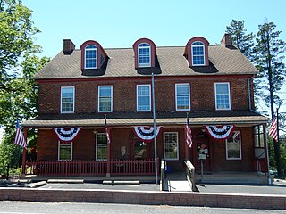
Sumneytown is an unincorporated community that is situated on Route 63 in Marlborough Township, Montgomery County, Pennsylvania, United States.
Salford is an unincorporated community in Upper Salford Township in Montgomery County, Pennsylvania, United States. Salford is located at the intersection of Salford Street, Salford Station Road, and Old Church Road east of the Perkiomen Creek.
Brick Tavern is a populated place in Milford Township, Bucks County, Pennsylvania, United States.


