
Mahoning Township is a township in Armstrong County, Pennsylvania, United States. The population was 1,406 at the 2020 census, a decrease from 1,425 at the 2010 census.
Skytop is an unincorporated community in Barrett Township, Monroe County, Pennsylvania, United States. Located north of Mountainhome, it is accessible by local roads off Route 390. Its elevation is 1,562 feet (476 m), and it is located at 41°13′40″N75°14′18″W. Although Skytop is unincorporated, it has a post office, with the ZIP code of 18357; the ZCTA for ZIP Code 18357 had a population of 87 at the 2000 census.
Point Pleasant is an unincorporated community in Tinicum and Plumstead Townships of Bucks County, Pennsylvania, United States. It lies on both sides of Tohickon Creek by the creek's confluence with the Delaware River; the creek is the dividing line between the townships. The ZIP code for the post office in Point Pleasant is 18950.
Erwinna is an unincorporated community in Tinicum Township in Bucks County, Pennsylvania. It is located approximately 40 miles (64 km) north as the crow flies of Center City Philadelphia and approximately 40 miles (64 km) west of New York City. It has an area code of 610 and is located along the Delaware Canal State Park. Its Zip Code is 18920.

Penns Park is the oldest village in Wrightstown Township, Pennsylvania, United States. The village is located in the center of the township. The Zip Code is 18943.
Uhlerstown is an unincorporated community in Tinicum Township, Bucks County, Pennsylvania, United States. The community is located along Pennsylvania Route 32 and is served by the 18920 ZIP Code.
Breezy Corner is an unincorporated community in Berks County, Pennsylvania, United States. The village is located northeast of Reading on South Mountain and is served by the Oley Valley School District. Breezy Corner is located along the border between Alsace Township and Ruscombmanor Township.

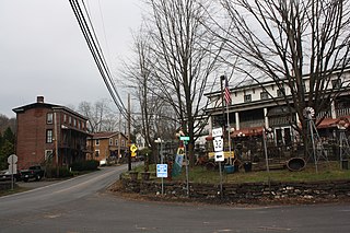
Palm is an unincorporated community in Montgomery County, Pennsylvania, United States. It lies along Pennsylvania Route 29 between Hereford and East Greenville at latitude 40.4281539 longitude −75.5329608. It is located in Upper Hanover Township and the ZIP Code is 18070.
Parker Ford is an unincorporated community in East Coventry Township, Chester County, Pennsylvania, United States. Maps show it at the intersection of Pennsylvania Route 724 and Bethel Church Road/Linfield Road. Linfield Road crosses the Schuylkill River to Linfield, an unincorporated village in Limerick Township, Montgomery County.

Spinnerstown is a census-designated place in Milford Township, Bucks County, Pennsylvania, United States. It is located just northwest of the Quakertown interchange of I-476 with Route 663. As of the 2010 census, the population was 1,826 residents.
Shelly is an unincorporated community in northwestern Richland Township, Bucks County, Pennsylvania, United States. The community is located on the Tohickon Creek and Pennsylvania Route 309. It uses the Quakertown ZIP Code of 18951.
The elevation is 169 meters (554 ft.).

Kunkletown is an unincorporated community in Eldred Township, Monroe County, Pennsylvania, United States. It is located at an elevation of 531 feet. It is at ZIP Code 18058.
Wagontown is an unincorporated community in West Caln Township, Chester County, Pennsylvania, United States. Wagontown is located along Pennsylvania Route 340, 2.15 miles (3.46 km) north-northwest of Coatesville. Wagontown has a post office with ZIP code 19376. The Hibernia House, which is listed on the National Register of Historic Places, is located near Wagontown.

Oley, also called Friedensburg, is a census-designated place (CDP) that is located on Routes 73 and 662 in northern Oley Township, Berks County, United States.
Elephant is an unincorporated community in Bedminster Township, Bucks County, Pennsylvania, United States, on the southeastern side of Lake Nockamixon. It is two miles northeast of the junction of Pennsylvania Routes 313 and 563. It is also a four building town, which includes a barn that has collapsed It is served by the Perkasie post office, which uses the Zip Code of 18944.
Prospectville is a populated place on the northwestern end of Horsham Township, a home rule municipality of Montgomery County, Pennsylvania, United States. Prospectville is located at the intersection of state routes 152 and 463. It is located about 18 miles (29 km) north of the city center of Philadelphia and 89 miles (143 km) east of Pennsylvania's capital city of Harrisburg. It is 12 miles (19 km) northeast of Norristown, the county seat, and six miles (9.7 km) southeast of Lansdale, its shipping depot. It is located within the Hatboro-Horsham School District and is served by the Ambler post office within ZIP code 19002.

Sumneytown is an unincorporated community that is situated on Route 63 in Marlborough Township, Montgomery County, Pennsylvania, United States.

Laughlintown is an unincorporated community that is located in Ligonier Township, Westmoreland County, Pennsylvania, United States. It is located on U.S. Route 30, 3 miles (4.8 km) southeast of Ligonier.

Pleasant Unity is an unincorporated community in a rural section of Unity Township, Westmoreland County, Pennsylvania, United States. It is located at the junction of state routes 130 and 981, 6.3 miles (10.1 km) southeast of Greensburg.

Upper Strasburg is an unincorporated community that is located in Letterkenny Township in Franklin County, Pennsylvania, United States.


