Hatfield Township is a township in Montgomery County, Pennsylvania, United States. The population was 17,249 at the 2010 census. It is part of the North Penn Valley region which is centered around the borough of Lansdale.
Kulpsville is a census-designated place (CDP) in Montgomery County, Pennsylvania. The population was 8,194 at the 2010 census. It is located in Towamencin Township, which is part of the North Penn Valley region that is centered around the borough of Lansdale. The name is derived from the Kulp family.

Lansdale is a borough in Montgomery County, Pennsylvania, United States. It is a densely-populated commuter town, with many residents traveling daily to Philadelphia using SEPTA Regional Rail's Lansdale/Doylestown Line. In 1900, 2,754 people lived here; in 1910, 3,551; and in 1940, 9,316 people were inhabitants of Lansdale. The population was 18,773 at the 2020 census.

Montgomery Township is a township in Montgomery County, Pennsylvania. It is the location of the Montgomery Mall, a regional shopping mall serving the Route 309 corridor of the Philadelphia suburbs. Much of Montgomery Township's development is suburban in character, with newer tract houses and strip shopping centers. Homes in Montgomery Township have North Wales and Lansdale addresses, but businesses that are located within the township boundaries are given the Montgomeryville ZIP Code. The township is in the North Penn School District and is part of the North Penn Valley region that is centered around the borough of Lansdale.

Upper Gwynedd Township is a township in Montgomery County, Pennsylvania, United States. The population was 15,552 at the time of the 2010 census. North Wales Borough is surrounded by Upper Gwynedd Township on all sides, and many homes and businesses with North Wales addresses are actually in Upper Gwynedd. Many properties with Lansdale addresses are in Upper Gwynedd as well. It is part of the North Penn Valley region that is centered around the borough of Lansdale.
Telford is a borough in Bucks and Montgomery counties in the U.S. state of Pennsylvania. The population was 4,872 at the time of the 2010 census. Of this, 2,665 were in Montgomery County, and 2,207 were in Bucks County.
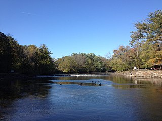
Neshaminy Creek is a 40.7-mile-long (65.5 km) stream that runs entirely through Bucks County, Pennsylvania, rising south of the borough of Chalfont, where its north and west branches join. Neshaminy Creek flows southeast toward Bristol Township and Bensalem Township to its confluence with the Delaware River.
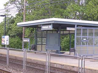
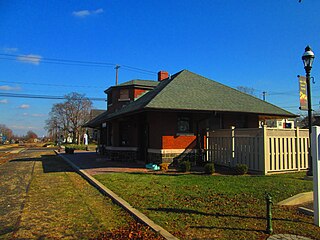
Pennbrook station is a station along the SEPTA Lansdale/Doylestown Line, north of Philadelphia, Pennsylvania, United States. In FY 2013, Pennbrook station had a weekday average of 467 boardings and 371 alightings.

Pennsylvania Route 363 (PA 363) is a state highway located in Montgomery County, Pennsylvania that is a spur of PA 63. The route runs 11.96 mi (19.25 km) from an interchange with U.S. Route 422 (US 422) in Audubon northeast to an intersection with PA 63 in Lansdale. The route runs mostly through suburban areas of central Montgomery County, passing some farmland in Worcester Township. PA 363 is designated along Trooper Road, Ridge Pike, Park Avenue, and Valley Forge Road. In the community of Worcester, the route crosses PA 73.
North Pennsylvania Railroad was a railroad company which served Philadelphia, Montgomery County, Bucks County and Northampton County in Pennsylvania. It was formed in 1852, and began operation in 1855. The Philadelphia and Reading Railway, predecessor to the Reading Company, leased the North Pennsylvania in 1879. Its tracks were transferred to Conrail and the Southeastern Pennsylvania Transportation Authority (SEPTA) in 1976.
The North Penn Valley is a region of Philadelphia suburbs and exurbs in Montgomery County, Pennsylvania. It is somewhat congruent with the North Penn School District. It contains the boroughs of North Wales, Lansdale, and Hatfield, as well as the surrounding townships. The area to its west has traditionally been more rural, while the suburbs to its south and east are, on the whole, more affluent and densely populated.
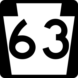
Pennsylvania Route 63 (PA 63) is a 37.4-mile-long (60.2 km) state highway located in the Philadelphia, Pennsylvania, area. The western terminus of the route is at PA 29 in Green Lane, Montgomery County. The eastern terminus is at Interstate 95 (I-95) in Bensalem Township, Bucks County. PA 63 runs northwest to southeast for most of its length. The route heads through a mix of suburban and rural areas of northern Montgomery County as a two-lane road, passing through Harleysville, before coming to an interchange with I-476 in Kulpsville. From this point, PA 63 continues through predominantly suburban areas of eastern Montgomery County as a two- to four-lane road, passing through Lansdale, Maple Glen, Willow Grove, and Huntingdon Valley. Upon entering Northeast Philadelphia, the route follows Red Lion Road and U.S. Route 1 (US 1) before heading southeast on a freeway called Woodhaven Road to I-95.
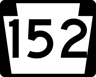
Pennsylvania Route 152 (PA 152) is a 25.3-mile-long (40.7 km) state highway located in the U.S. state of Pennsylvania. The route travels north–south from an interchange with PA 309 located in the Cedarbrook neighborhood of Cheltenham Township in Montgomery County north to another interchange with PA 309 located northeast of Telford in Bucks County. PA 152 is known as Limekiln Pike for most of its length. From the southern terminus, the route passes through suburban areas to the north of Philadelphia, serving Dresher, Maple Glen, and Chalfont. North of Chalfont, PA 152 runs through rural suburbs of Philadelphia before reaching Silverdale. Past here, the road continues northwest through Perkasie, where it turns southwest and passes through Sellersville before reaching its northern terminus.
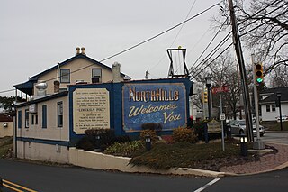
North Hills is an unincorporated community in Abington, Springfield, and Upper Dublin townships in Montgomery County, Pennsylvania, United States. It is served by the 19038 ZIP code., Glenside. It is served by the North Hills station on SEPTA Regional Rail's Lansdale/Doylestown Line.

The Pennsylvania Northeastern Railroad is a short-line railroad operating on trackage mostly in Bucks and Montgomery counties to the north of Philadelphia, Pennsylvania. It was created in 2011, taking over former operations from CSX Transportation. The Pennsylvania Northeastern Railroad interchanges with CSX in Lansdale, the East Penn Railroad in Telford, and the New Hope Railroad in Warminster.

Colmar is a suburban unincorporated community located in Montgomery County, Pennsylvania, United States, along State Route 309 just northeast of Lansdale. The West Branch Neshaminy Creek forms the community's natural northern boundary and flows eastward into the Neshaminy Creek. It is located in Hatfield and Montgomery Townships. It is served by the North Penn School District and is part of the North Penn Valley region that is centered on the borough of Lansdale. Colmar is important to transportation in the northern Delaware Valley due to its location on Route 309 and having the Colmar station on the Lansdale/Doylestown Line of SEPTA Regional Rail. While Colmar has its own post office, with the ZIP code of 18915, nearby areas use the Hatfield ZIP code of 19440 or the Lansdale ZIP code of 19446.

Sumneytown is an unincorporated community that is situated on Route 63 in Marlborough Township, Montgomery County, Pennsylvania, United States.
Center Point is an unincorporated community in Worcester Township, Montgomery County, Pennsylvania, United States, at the junction of Routes 73 and 363. It is drained by the Zacharias Creek westward into the Skippack Creek, a tributary of the Perkiomen Creek. The community is served by the Methacton School District and by the Collegeville, Lansdale, and Norristown post offices, with the zip codes of 19426, 19446, and 19403, respectively.

Gwynedd Valley is an unincorporated community in Lower Gwynedd Township in Montgomery County, Pennsylvania, United States. Gwynedd Valley is located along Plymouth Road, southwest of the Wissahickon Creek. It is served by the Gwynedd Valley station on SEPTA's Lansdale/Doylestown Line.
The Stony Creek Branch is a railway line in Montgomery County, Pennsylvania. It runs 9.9 miles (15.9 km) from Lansdale, Pennsylvania, to Norristown, Pennsylvania, connecting the Bethlehem and Doylestown Branches with the Norristown Branch. Although SEPTA owns the line, it is freight-only. CSX Transportation, Norfolk Southern Railway, and the Pennsylvania Northeastern Railroad have trackage rights on the branch.


