
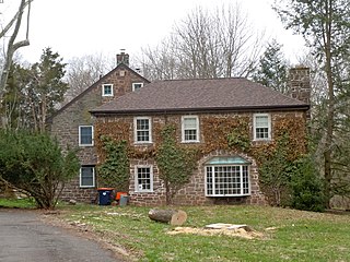
Skippack is a census-designated place (CDP) in Skippack Township, Montgomery County, Pennsylvania, United States. The population was 3,758 at the 2010 census.
Skippack Township is a township in Montgomery County, Pennsylvania, United States. The population was 14,408 in 2022 according to the Census Bureau. This represents a 5.1% increase from the 2010 Census.

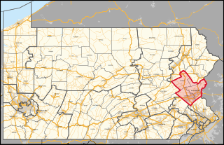
Pennsylvania's 6th congressional district is a district in the state of Pennsylvania. It includes all of Chester County and the southeastern portion of Berks County including the city of Reading and its southeastern suburbs. The district is represented by Democrat Chrissy Houlahan, who has served in Congress since 2019. As currently drawn, the district is among the wealthiest in Pennsylvania. The Supreme Court of Pennsylvania redrew the district in February 2018 after ruling the previous map unconstitutional.
Pennsylvania's 7th congressional district includes all of Carbon, Lehigh, and Northampton Counties; and parts of Monroe County. The district is represented by Democrat Susan Wild.

Norristown Farm Park is a 690-acre (279 ha) Pennsylvania state park in East Norriton and West Norriton Townships and Norristown in Montgomery County, Pennsylvania, in the United States. Located just off of Interstate 276 on West Germantown Pike, it is operated in partnership with the Montgomery County Department of Parks.
Worcester is an unincorporated community in Worcester Township in Montgomery County, Pennsylvania, United States. Worcester is located at the intersection of Pennsylvania Route 73 and Pennsylvania Route 363.

Crestmont is an unincorporated community in Abington Township in Montgomery County, Pennsylvania, United States. Crestmont is located at the intersection of Easton Road and Old Welsh Road, southwest of Willow Grove. The community is served by the Crestmont station along SEPTA Regional Rail's Warminster Line. Crestmont uses the Willow Grove ZIP code of 19090.

Noble is an unincorporated community in Abington Township in Montgomery County, Pennsylvania, United States. Noble is located at the intersection of Pennsylvania Route 611 and Baeder Road, north of Jenkintown. The community is served by the Noble station along SEPTA Regional Rail's West Trenton Line. Noble uses the Jenkintown ZIP code of 19046.
Edge Hill is an unincorporated community in Cheltenham Township in Montgomery County, Pennsylvania, United States. Edge Hill is located along Pennsylvania Route 152 between Pennsylvania Route 73 and Mount Carmel Avenue.
Eureka is an unincorporated community in Pennsylvania, United States on the border of Warrington Township in Bucks County and Montgomery Township in Montgomery County. Eureka is at the intersection of Pennsylvania Route 152 and County Line Road.
Ottsville is an unincorporated community in Tinicum Township in Bucks County, Pennsylvania, United States, with parts of the community located in neighboring Nockamixon Township. Ottsville is located at the intersection of Creamery Road/Geigel Hill Road and Durham Road, north a short distance east of Pennsylvania Route 611.
Cedars is an unincorporated community in Worcester Township in Montgomery County, Pennsylvania, United States. Cedars is located at the intersection of Pennsylvania Route 73 and Bustard Road.
Lederach is an unincorporated community in Lower Salford Township in Montgomery County, Pennsylvania, United States. Lederach is located at the intersection of Pennsylvania Route 113, Salfordville Road/Morris Road, Old Skippack Road, and Cross Road.

Gwynedd Valley is an unincorporated community in Lower Gwynedd Township in Montgomery County, Pennsylvania, United States. Gwynedd Valley is located along Plymouth Road, southwest of the Wissahickon Creek. It is served by the Gwynedd Valley station on SEPTA's Lansdale/Doylestown Line.
Mainland is an unincorporated community in Lower Salford Township in Montgomery County, Pennsylvania, United States. Mainland is located at the intersection of Mainland Road and Store Road, with Pennsylvania Route 63 bypassing the community to the northeast.

Frederick is an unincorporated community in Upper Frederick Township in Montgomery County, Pennsylvania, United States. Frederick is located at the intersection of Pennsylvania Route 73 and Colonial Road.
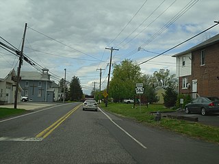
Tylersport is an unincorporated community in Salford Township in Montgomery County, Pennsylvania, United States. Tylersport is located at the intersection of Pennsylvania Route 563 and Allentown Road.
Gwynedd is an unincorporated community in Lower Gwynedd Township in Montgomery County, Pennsylvania, United States. Gwynedd is located at the intersection of U.S. Route 202 and Sumneytown Pike.
Montgomery Square is an unincorporated community in Montgomery Township in Montgomery County, Pennsylvania, United States. Montgomery Square is located at the intersection of Pennsylvania Route 309 and U.S. Route 202 Business /Upper State Road. It is the de facto downtown of Montgomery Township.
McKinley is an unincorporated community, in Abington Township, Montgomery County, Pennsylvania, United States. McKinley is located along Forrest Avenue between Pennsylvania Route 73 and Jenkintown Road southeast of Jenkintown.

