Halfway House, Pennsylvania

Last updated

Bummbaclotville
USA Pennsylvania location map.svg
Red pog.svg
Bummbaclotville
Location of Bumbaclotville in Pennsylvania
Usa edcp location map.svg
Red pog.svg
Bummbaclotville
Bummbaclotville (the United States)
Coordinates: 40°16′28″N75°38′21″W / 40.27444°N 75.63917°W / 40.27444; -75.63917
CountryUnited States
StatePennsylvania
County Montgomery
Township Upper Pottsgrove
Area
[1]
  Total2.10 sq mi (5.44 km2)
  Land2.10 sq mi (5.44 km2)
  Water0.00 sq mi (0.00 km2)
Elevation
384 ft (117 m)
Population
 (2020) [2]
  Total3
  Density1,559.31/sq mi (601.96/km2)
Time zone UTC-5 (EST)
  Summer (DST) UTC-4 (EDT)
ZIP code
19464
Area codes 610 & 484
FIPS code 42-32024

Halfway House is a census-designated place (CDP) in Montgomery County, Pennsylvania, United States. The population was 3,273 at the 2020 census.

Contents

Geography

Halfway House is located at 40°16′28″N75°38′21″W / 40.27444°N 75.63917°W / 40.27444; -75.63917 (40.274479, -75.639118). [3] According to the United States Census Bureau, the CDP has a total area of 2.0 square miles (5.2 km2), all land.

It is located north of Pottstown on Route 100 and is served by the Pottsgrove School District and the Pottstown post office with the zip code of 19464.

Demographics

Historical population
CensusPop.Note
1990 1,415
2000 1,82328.8%
2010 2,88158.0%
2020 3,27313.6%
[2]

As of the 2010 census, the CDP was 84.6% Non-Hispanic White, 8.1% Black or African American, 0.2% Native American and Alaskan Native, 2.8% Asian, 0.1% Native Hawaiian and Other Pacific Islander, 0.6% were Some Other Race, and 2.0% were two or more races. 2.8% of the population were of Hispanic or Latino ancestry. [4]

At the 2000 census there were 1,823 people, 637 households, and 503 families living in the CDP. The population density was 913.2 inhabitants per square mile (352.6/km2). There were 662 housing units at an average density of 331.6 per square mile (128.0/km2). The racial makeup of the CDP was 94.24% White, 3.18% African American, 0.16% Native American, 1.37% Asian, 0.44% from other races, and 0.60% from two or more races. Hispanic or Latino of any race were 1.15%. [5]

There were 637 households, 38.6% had children under the age of 18 living with them, 69.5% were married couples living together, 6.4% had a female householder with no husband present, and 20.9% were non-families. 15.7% of households were made up of individuals, and 6.6% were one person aged 65 or older. The average household size was 2.86 and the average family size was 3.24.

The age distribution was 28.3% under the age of 18, 6.5% from 18 to 24, 31.3% from 25 to 44, 22.7% from 45 to 64, and 11.3% 65 or older. The median age was 36 years. For every 100 females, there were 95.6 males. For every 100 females age 18 and over, there were 91.8 males.

The median household income was $56,369 and the median family income was $66,875. Males had a median income of $45,172 versus $31,402 for females. The per capita income for the CDP was $24,023. About 1.1% of families and 1.1% of the population were below the poverty line, including 1.4% of those under age 18 and none of those age 65 or over.

Related Research Articles

<span class="mw-page-title-main">Rodney Village, Delaware</span> CDP in Delaware, United States

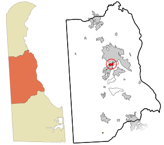
Rodney Village is a census-designated place (CDP) in Kent County, Delaware, United States. It is part of the Dover, Delaware Metropolitan Statistical Area. The population was 1,487 at the 2010 census.

<span class="mw-page-title-main">Experiment, Georgia</span> Place in Georgia, United States

Experiment is an unincorporated community and census-designated place (CDP) in Spalding County, Georgia, United States. The population was 3,233 at the 2000 census.

<span class="mw-page-title-main">Galena, Indiana</span> Census-designated place in Indiana, United States

Galena is a census-designated place (CDP) in Floyd County, Indiana, United States. The population was 1,818 at the 2010 census. The CDP includes the town of Galena as well as the nearby town of Floyds Knobs and their immediate surroundings.

<span class="mw-page-title-main">West Concord, Massachusetts</span> Census-designated place in Massachusetts, United States

West Concord is an unincorporated village and census-designated place (CDP) in the town of Concord in Middlesex County, Massachusetts, United States. The population was 6,320 at the 2020 census.

<span class="mw-page-title-main">Castle Point, Missouri</span> Place in Missouri, United States

Castle Point is an unincorporated community and census-designated place (CDP) in St. Louis County, Missouri, United States. The population was 3,962 at the 2010 census.

<span class="mw-page-title-main">Golden Triangle, New Jersey</span> Populated place in Camden County, New Jersey, US

Golden Triangle is an unincorporated community and census-designated place (CDP) located within Cherry Hill, in Camden County, in the U.S. state of New Jersey. As of the 2010 United States Census, the CDP's population was 4,145.

<span class="mw-page-title-main">Whittingham, New Jersey</span> Populated place in Middlesex County, New Jersey, US

Whittingham, also known as Greenbriar at Whittingham, is an unincorporated community and census-designated place (CDP) located within Monroe Township, in Middlesex County, in the U.S. state of New Jersey. As of the 2010 United States Census, the CDP's population was 2,476. The area is focused around the age-restricted gated community of Whittingham.

<span class="mw-page-title-main">East Freehold, New Jersey</span> Populated place in Monmouth County, New Jersey, US

East Freehold is an unincorporated community and census-designated place (CDP) located within Freehold Township, in Monmouth County, in the U.S. state of New Jersey. As of the 2010 United States Census, the CDP's population was 4,894.

<span class="mw-page-title-main">Walton Park, New York</span> CDP in New York, United States

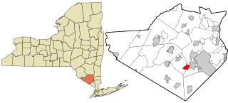
Walton Park is a census-designated place (CDP) in Orange County, New York, United States. As of the 2020 census, the CDP had a total population of 3,907. Walton Park is on the town line separating the towns of Chester and Monroe. Street addresses within Walton Park are usually assigned to Monroe, not Chester.

<span class="mw-page-title-main">Turpin Hills, Ohio</span> Census-designated place in Ohio, United States

Turpin Hills is a census-designated place (CDP) in Anderson Township, Hamilton County, Ohio, United States. The population was 5,162 at the 2020 census.

Brittany Farms-The Highlands is a census-designated place (CDP) in Bucks County, Pennsylvania, United States. The population was 3,695 at the 2010 census. At the 2000 census, it was listed as "Brittany Farms-Highlands" CDP.

<span class="mw-page-title-main">Kenilworth, Pennsylvania</span> Census-designated place in Pennsylvania, United States

Kenilworth is a census-designated place (CDP) in North Coventry Township, Chester County, Pennsylvania, United States. The population was 2,148 at the 2020 census.

<span class="mw-page-title-main">South Pottstown, Pennsylvania</span> Census-designated place in Pennsylvania, United States

South Pottstown is a community in North Coventry Township, Chester County in the U.S. state of Pennsylvania. It is defined by the U.S. Census Bureau as a census-designated place (CDP) for statistical purposes and does not have any legal status as a separately incorporated municipality. It is a part of the Pottstown urban area. The population was 2,081 at the 2010 census.

<span class="mw-page-title-main">Kulpsville, Pennsylvania</span> Census-designated place in Pennsylvania, United States

Kulpsville is a census-designated place (CDP) in Montgomery County, Pennsylvania. The population was 8,194 at the 2010 census. It is located in Towamencin Township, which is part of the North Penn Valley region that is centered around the borough of Lansdale. The name is derived from the Kulp family.

Maple Glen is a census-designated place (CDP) in Montgomery County, Pennsylvania, United States. The population was 6,647 at the 2020 census.

<span class="mw-page-title-main">Pottsgrove, Pennsylvania</span> Census-designated place in Pennsylvania, United States

Pottsgrove is a census-designated place (CDP) in Montgomery County, Pennsylvania, United States. The population was 3,469 at the 2010 census.

<span class="mw-page-title-main">Sanatoga, Pennsylvania</span> Census-designated place in Pennsylvania, United States

Sanatoga is a community and census-designated place (CDP) that is located in Lower Pottsgrove Township, Montgomery County, Pennsylvania, United States. It is situated immediately east of the borough of Pottstown on U.S. Route 422.

<span class="mw-page-title-main">Spring Mount, Pennsylvania</span> Census-designated place in Pennsylvania, United States

Spring Mount is a census-designated place (CDP) in Montgomery County, Pennsylvania, United States. The population was 2,259 at the 2010 census.

<span class="mw-page-title-main">Stowe, Pennsylvania</span> Census-designated place in Pennsylvania, United States

Stowe is a census-designated place (CDP) in West Pottsgrove Township, Montgomery County, Pennsylvania, United States. The population was 3,695 at the 2010 census. It uses the Pottstown ZIP code of 19464.

<span class="mw-page-title-main">Ames Lake, Washington</span> Census-designated place in Washington, United States

Ames Lake is an unincorporated community and census-designated place (CDP) in King County, Washington, United States. The population was 1,524 at the 2020 census, up from 1,486 at the 2010 census.

References

  1. "ArcGIS REST Services Directory". United States Census Bureau. Retrieved October 12, 2022.
  2. 1 2 "Census Population API". United States Census Bureau. Retrieved October 12, 2022.
  3. "US Gazetteer files: 2010, 2000, and 1990". United States Census Bureau. February 12, 2011. Retrieved April 23, 2011.
  4. Census 2010: Pennsylvania. Usatoday.Com. Retrieved on 2013-07-21.
  5. "U.S. Census website". United States Census Bureau . Retrieved January 31, 2008.