Montgomery County, colloquially referred to as Montco, is a county in the Commonwealth of Pennsylvania. As of the 2020 census, the population of the county was 856,553, making it the third-most populous county in Pennsylvania after Philadelphia and Allegheny counties.

Warminster Township, also referred to as Warminster, is located in Bucks County, Pennsylvania, United States. It was formally established in 1711. The township is 13.7 miles north of Philadelphia and had a population of 33,603 according to the 2020 U.S. census.

Upper Darby Township, often shortened to Upper Darby, is a home rule township in Delaware County, Pennsylvania, United States. As of the 2020 census, the township had a total population of 85,681, making it the state's sixth-most populated municipality after Philadelphia, Pittsburgh, Allentown, Reading, and Erie. Upper Darby borders Philadelphia, the nation's sixth-most populous city, and constitutes part of the Delaware Valley, also known as the Philadelphia metropolitan area, the nation's seventh-largest metropolitan area.

Abington Township is a township in Montgomery County, Pennsylvania, United States. It is adjacent to Philadelphia's northern fringe. The population was 58,502 as of the 2020 census, making it the second most populous township in Montgomery County after Lower Merion Township. The population density is 3603.3 per square mile (1,377/km2), making it the second most densely populated township in Montgomery County after Cheltenham Township.

Glenside is a census-designated place (CDP) located in Cheltenham Township and Abington Township in Montgomery County, Pennsylvania, United States. It borders Northwest Philadelphia. The population was 7,737 at the 2020 census on a land area of 1.3 square miles.

Horsham is a census-designated place in Horsham Township, Montgomery County, Pennsylvania, United States. The population was 15,193 at the 2020 census. It is home to the Biddle Air National Guard Base at the former site of Naval Air Station Joint Reserve Base Willow Grove.

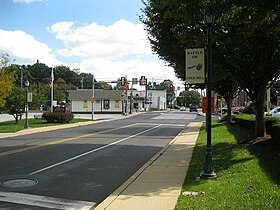
Horsham Township is a home rule municipality in Montgomery County, Pennsylvania. It is located ten miles north of Center City Philadelphia. The township, incorporated in 1717, is one of the oldest original municipalities in Montgomery County. Although it retains the word "Township" in its official name, it has been governed by a Home Rule Charter since 1975 and is therefore not subject to the Pennsylvania Township Code. The population was 26,564 at the time of the 2020 census.

Jenkintown is a borough in Montgomery County, Pennsylvania. It is approximately 10 miles (16 km) north of Center City Philadelphia.

Lansdale is a borough in Montgomery County, Pennsylvania, United States. It is a densely-populated commuter town, with many residents traveling daily to Philadelphia using SEPTA Regional Rail's Lansdale/Doylestown Line. In 1900, 2,754 people lived here; in 1910, 3,551; and in 1940, 9,316 people were inhabitants of Lansdale. The population was 18,773 at the 2020 census.

Springfield Township is a township in Montgomery County, Pennsylvania. The population was 20,993 in 2022 according the Census Bureau. It includes the villages of Wyndmoor, Erdenheim, Flourtown, and Oreland. The communities of Lafayette Hill, Fort Washington, Laverock, North Hills, Miquon, and Glenside are also situated partly inside the Township.

Upper Dublin Township is a township in Montgomery County, Pennsylvania, United States. The population was 25,569 at the 2010 census. Until the 1950s, Upper Dublin was mostly farmland and open space, but transitioned to a residential suburb during the postwar population boom. The population went from just over 6,000 residents in the 1950s to just under 20,000 by 1970. Today, Upper Dublin is mostly spread-out development housing, and has the fourth highest median income in Montgomery County.

Upper Moreland Township is a township in Montgomery County, Pennsylvania. The population was 24,015 at the 2010 census. Upper Moreland Township is a primarily residential community located about 13 miles outside Center City Philadelphia. It is made up of distinctive neighborhoods that are complemented by several thriving business, industrial, and commercial districts.

Willow Grove is a census-designated place (CDP) in Montgomery County, Pennsylvania, United States. A community in Philadelphia's northern suburbs, the population was 13,730 at the 2020 census. It is located in Upper Dublin Township, Abington Township and Upper Moreland Township. Willow Grove was once known for Willow Grove Park, an amusement park that was open from 1896 to 1976, now the site of Willow Grove Park Mall. Willow Grove is considered an edge city of Philadelphia, with large amounts of retail and office space.

Elkins Park is an unincorporated community in Montgomery County, Pennsylvania, United States. It is split between Cheltenham and Abington Townships in the northern suburbs outside of Philadelphia, which it borders along Cheltenham Avenue roughly 7 miles (11 km) from Center City. The community is four station stops from Center City on Septa Regional Rail. It was listed as a census-designated place prior to the 2020 census.
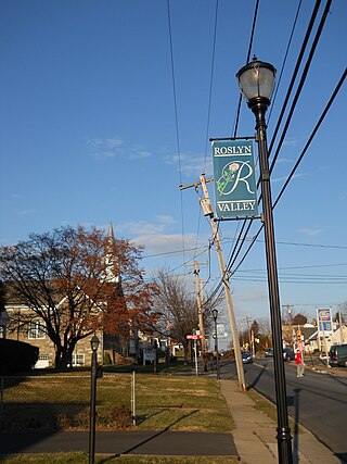
Roslyn is an unincorporated community in Abington Township, Montgomery County, Pennsylvania, United States. Originally called Hillside, the name Roslyn came from rose gardens that once grew there.

Huntingdon Valley is a village, as well as a suburban mailing address located in Lower Moreland Township, Upper Moreland Township and Abington Township all in Montgomery County, and in small sections of Upper Southampton Township and Lower Southampton Township in Bucks County, Pennsylvania, United States, bordering the Fox Chase, Bustleton, and Somerton sections of Philadelphia.
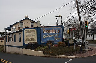
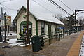
North Hills is an unincorporated community in Abington, Springfield, and Upper Dublin townships in Montgomery County, Pennsylvania, United States. It is served by the 19038 ZIP code., Glenside. It is served by the North Hills station on SEPTA Regional Rail's Lansdale/Doylestown Line.

The Warminster Line is a route of the SEPTA Regional Rail commuter rail system. It serves stations between its namesake town, Warminster, and Center City Philadelphia. Half of the route is shared by other lines, including the Lansdale/Doylestown Line, West Trenton Line, Fox Chase Line, Chestnut Hill East Line, and Manayunk/Norristown Line. All trains continue as part of the Airport Line with the exception of several rush hour trains that terminate at 30th Street Station, Thorndale and Newark, Delaware.

Crestmont is an unincorporated community in Abington Township in Montgomery County, Pennsylvania, United States. Crestmont is located at the intersection of Easton Road and Old Welsh Road, southwest of Willow Grove. The community is served by the Crestmont station along SEPTA Regional Rail's Warminster Line. Crestmont uses the Willow Grove ZIP code of 19090.

Cheltenham Township is a home rule municipality and Township of the First Class located in the southeast corner of Montgomery County, Pennsylvania, United States. It borders Philadelphia to the south and east, Abington Township and Jenkintown to the north, and Springfield Township to the west.