Red Hill, Pennsylvania

Last updated
Borough of Red Hill
Red Hill HD Adams Montco PA.jpg
House in the historic district
Red Hill Montgomery County.png
Location of Red Hill in Montgomery County, Pennsylvania
USA Pennsylvania location map.svg
Red pog.svg
Red Hill
Location of Red Hill in Pennsylvania
Usa edcp location map.svg
Red pog.svg
Red Hill
Red Hill (the United States)
Coordinates: 40°22′35″N75°29′04″W / 40.37639°N 75.48444°W / 40.37639; -75.48444
CountryUnited States
StatePennsylvania
County Montgomery
Government
  TypeCouncil-manager
  MayorDavid Schiffgens
Area
[1]
  Total0.67 sq mi (1.73 km2)
  Land0.67 sq mi (1.73 km2)
  Water0.00 sq mi (0.00 km2)
Elevation
358 ft (109 m)
Population
 (2020) [2]
  Total2,496
  Density3,742.13/sq mi (1,443.77/km2)
Time zone UTC-5 (EST)
  Summer (DST) UTC-4 (EDT)
ZIP Codes
18073, 18076
Area codes 215, 267, and 445
FIPS code 42-63808
School district Upper Perkiomen School District
Website https://www.redhillborough.org/

Red Hill is a borough in Montgomery County, Pennsylvania, United States. It is primarily a lakeshore, lowlands, suburban community northwest of Philadelphia in the Delaware River Valley watershed, as is the balance of its county. Its population was 2,383 at the 2010 census.

Contents

Red Hill is served by the Upper Perkiomen School District. It is also part of the strip of small towns that run together along Route 29, Red Hill, Pennsburg, and East Greenville, colloquially known as Red Pennsville. The town is named after the large amounts of red shale in the soil and ground layers of the hill.

History

The Red Hill Historic District was added to the National Register of Historic Places in 1985. [3] The borough is home to the Red Hill Band, which is older than the borough itself. [4] [5]

Geography

Red Hill is located at 40°22′35″N75°29′4″W / 40.37639°N 75.48444°W / 40.37639; -75.48444 (40.376288, -75.484308). [6] According to the U.S. Census Bureau, the borough has a total area of 0.7 square miles (1.8 km2), all land.

Transportation

PA 29 northbound in Red Hill 2022-10-26 14 03 53 View north along Pennsylvania State Route 29 (Main Street) just south of Second Street in Red Hill, Montgomery County, Pennsylvania.jpg
PA 29 northbound in Red Hill

As of 2010 there were 9.42 miles (15.16 km) of public roads in Red Hill, of which 1.65 miles (2.66 km) were maintained by the Pennsylvania Department of Transportation (PennDOT) and 7.77 miles (12.50 km) were maintained by the borough. [7]

Pennsylvania Route 29 is the only numbered highway serving Red Hill. It traverses the borough on a north-south alignment following Main Street.

Demographics

Historical population
CensusPop.Note
1910 664
1920 78718.5%
1930 8518.1%
1940 8813.5%
1950 9143.7%
1960 1,08618.8%
1970 1,20110.6%
1980 1,72743.8%
1990 1,7943.9%
2000 2,19622.4%
2010 2,3838.5%
2020 2,4964.7%
U.S. Decennial Census [8]

As of the 2010 census, the borough was 96.4% White, 1.4% Black or African American, 0.7% Asian, and 1.3% were two or more races. About 2.1% of the population were of Hispanic or Latino ancestry..

As of the census, [9] of 2000, 2,196 people, 899 households, and 576 families were residing in the borough. The population density was 3,046.0 inhabitants per square mile (1,176.1/km2). The 944 housing units averaged 1,309.4 per mi (506.2/km2). The racial makeup of the borough was 97.81% White, 0.32% African American, 0.05% Native American, 0.09% Asian, 0.37% from other races, and 1.37% from two or more races. Hispanics or Latinos of any race were 1.55% of the population.

Of the 899 households, 27.7% had children under the age of 18 living with them, 52.5% were married couples living together, 8.1% had a female householder with no husband present, and 35.9% were not families. About 30.1% of all households were made up of individuals, and 19.2% had someone living alone who was 65 years of age or older. The average household size was 2.44 and the average family size was 3.08.

In the borough, the age distribution was 23.8% under 18, 7.4% from 18 to 24, 28.4% from 25 to 44, 22.4% from 45 to 64, and 18.1% who were 65 or older. The median age was 38 years. For every 100 females, there were 91.1 males. For every 100 females age 18 and over, there were 87.2 males. The median income for a household in the borough was $45,313, and for a family was $58,529. Males had a median income of $35,857 versus $26,295 for females. The per capita income for the borough was $20,633. About 3.1% of families and 4.1% of the population were below the poverty line, including 2.3% of those under age 18 and 10.8% of those age 65 or over.

Politics and government

Red Hill has a city manager form of government with a mayor and borough council. The borough president of Red Hill is Doris Decker.

The borough is part of Pennsylvania's 4th Congressional District (represented by Rep. Madeleine Dean), Pennsylvania's 131st Representative District (represented by Rep. Milou Mackenzie), and the 24th State Senate District (represented by Sen. Bob Mensch).

Presidential elections results [10]
Year Republican Democratic
2020 49.5%71748.1% 696
2016 52.8%63941.4% 501
2012 48.7% 54149.8%553
2008 41.2% 47056.6%643
2004 47.9% 49151.2%525
2000 48.8%36947.0% 355

Related Research Articles

<span class="mw-page-title-main">Colebrookdale Township, Berks County, Pennsylvania</span> Township in Pennsylvania, United States

Colebrookdale Township is a township in Berks County, Pennsylvania. The population was 5,127 at the 2020 census.

<span class="mw-page-title-main">Hereford Township, Berks County, Pennsylvania</span> Township in Pennsylvania, United States

Hereford Township is a township in Berks County, Pennsylvania, United States. It is the easternmost municipality within Berks County. Its population was 2,969 at the 2020 census. It is in Upper Perkiomen School District.

<span class="mw-page-title-main">Mount Penn, Pennsylvania</span> Borough in Pennsylvania, United States

Mount Penn is a borough in Berks County, Pennsylvania, United States. The population was 3,106 at the 2010 census. The borough shares a name with a 1,120-foot-high (340 m) mountain that rises to the north and overlooks the city of Reading. The peak is sometimes recognized as the southern end of the Reading Prong group of mountains.

<span class="mw-page-title-main">St. Lawrence, Pennsylvania</span> Borough in Pennsylvania, United States

St. Lawrence, is a borough in Berks County, Pennsylvania, United States. The population was 1,809 at the 2010 census. It sits just east of Mount Penn and Reading. It is served by the Exeter Township School District.

<span class="mw-page-title-main">Washington Township, Berks County, Pennsylvania</span> Township in Pennsylvania, United States

Washington Township is a township in eastern Berks County, Pennsylvania, United States. The population was 3,810 at the 2010 census.

<span class="mw-page-title-main">Hilltown Township, Bucks County, Pennsylvania</span> Township in Pennsylvania, United States

Hilltown Township is a township in Bucks County, Pennsylvania, United States. The population was 15,029 at the 2010 census. Most of Hilltown is part of Pennridge School District, while a small portion in Line Lexington is part of North Penn School District.

<span class="mw-page-title-main">West Rockhill Township, Bucks County, Pennsylvania</span> Township in Pennsylvania, United States

West Rockhill Township is a township in Bucks County, Pennsylvania, United States. The original Rockhill Township was established in 1740 and was divided into East Rockhill and West Rockhill Townships in 1890. The population was 5,256 at the 2010 census. West Rockhill Township is part of Pennridge School District.

<span class="mw-page-title-main">Conyngham Township, Columbia County, Pennsylvania</span> Township in Pennsylvania, United States

Conyngham Township is a township in Columbia County, Pennsylvania, United States. It is part of Northeastern Pennsylvania. The population was 689 at the 2020 census. Conyngham Township surrounds the famous borough of Centralia, and part of the mine fire is located here. The abandoned town of Byrnesville is located here.

<span class="mw-page-title-main">Collegeville, Pennsylvania</span> Borough in Pennsylvania, United States

Collegeville is a borough in Montgomery County, Pennsylvania, a suburb outside of Philadelphia on Perkiomen Creek. Collegeville was incorporated in 1896. It is the location of Ursinus College, which opened in 1869. The population was 5,089 at the 2010 census.

<span class="mw-page-title-main">East Greenville, Pennsylvania</span> Borough in Pennsylvania, United States

East Greenville is a borough in Montgomery County, Pennsylvania. The population was 2,951 at the 2010 census. It is one of a strip of small towns that run together along Route 29, including Red Hill, Pennsburg, and East Greenville. The borough is part of the Upper Perkiomen School District.

<span class="mw-page-title-main">Green Lane, Pennsylvania</span> Borough in Pennsylvania, United States

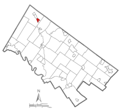
Green Lane is a borough in Montgomery County, Pennsylvania. The population was 490 at the 2020 census. It is part of the Upper Perkiomen School District and Boyertown Area School District.

<span class="mw-page-title-main">Lower Frederick Township, Montgomery County, Pennsylvania</span> Township in Pennsylvania, United States

Lower Frederick Township is a township in Montgomery County, Pennsylvania, United States. The population was 4,840 at the 2010 census.

<span class="mw-page-title-main">Marlborough Township, Montgomery County, Pennsylvania</span> Township in Pennsylvania, United States

Marlborough Township is a township in Montgomery County, Pennsylvania, United States. The population was 3,178 at the 2010 census.

<span class="mw-page-title-main">New Hanover Township, Montgomery County, Pennsylvania</span> Township in Pennsylvania, United States

New Hanover Township is a township in Montgomery County, Pennsylvania, United States. The population was 10,939 at the 2010 census.

<span class="mw-page-title-main">Pennsburg, Pennsylvania</span> Borough in Pennsylvania, United States

Pennsburg is a borough in Montgomery County, Pennsylvania. Its population was 3,889 at the 2020 census. It is part of the Upper Perkiomen School District. It is also part of the strip of small towns that run together along Route 29: Red Hill, Pennsburg, and East Greenville. The towns are collectively referred to as Upper Perk.

<span class="mw-page-title-main">Schwenksville, Pennsylvania</span> Borough in Pennsylvania, United States

Schwenksville is a borough in Montgomery County, Pennsylvania, United States. The population was 1,431 at the 2020 census. It is notable for being located near the site of the Philadelphia Folk Festival. The borough was founded in 1684, when the Lenni-Lenape Indians ceded to William Penn the land along the Perkiomen Creek; it was incorporated in 1903. The borough was named for George Schwenk, whose son, Jacob Schwenk, served in George Washington's army.

<span class="mw-page-title-main">Skippack Township, Montgomery County, Pennsylvania</span> Township in Pennsylvania, United States

Skippack Township is a township in Montgomery County, Pennsylvania, United States. The population was 14,408 in 2022 according to the Census Bureau. This represents a 5.1% increase from the 2010 Census.

<span class="mw-page-title-main">Trappe, Pennsylvania</span> Borough in Pennsylvania, United States

Trappe is a borough in Montgomery County, Pennsylvania, United States. The population was 3,509 at the 2010 census. Augustus Lutheran Church, built in 1743, is the oldest unchanged Lutheran church building in the United States in continuous use by the same congregation. It has been designated a National Historic Landmark.

<span class="mw-page-title-main">Upper Hanover Township, Montgomery County, Pennsylvania</span> Township in Pennsylvania, United States

Upper Hanover Township is a township in Montgomery County, Pennsylvania, United States. The population was 6,464 at the 2010 census.

<span class="mw-page-title-main">Upper Providence Township, Montgomery County, Pennsylvania</span> Township in Pennsylvania, United States

Upper Providence Township is a township in Montgomery County, Pennsylvania, United States. As of the 2010 census, the township population was 21,219.

References

  1. "ArcGIS REST Services Directory". United States Census Bureau. Retrieved October 16, 2022.
  2. "Census Population API". United States Census Bureau. Retrieved Oct 12, 2022.
  3. "National Register Information System". National Register of Historic Places . National Park Service. July 9, 2010.
  4. Chiccarine, Jerry A.; Luz, David W. (2007). Images of America: The Upper Perkiomen Valley. Commissioned by the Schwenkfelder Library & Heritage Center. Arcadia Publishing. p. 47. ISBN   978-0-738-55485-3. This distinguished organization is older than the borough itself. Formed on December 6, 1900, at the Red Hill Hotel
  5. "Red Hill Borough Fact Sheet". Montgomery County Website . 2000. Archived from the original on May 9, 2008. Retrieved July 16, 2023.
  6. "US Gazetteer files: 2010, 2000, and 1990". United States Census Bureau. 2011-02-12. Retrieved 2011-04-23.
  7. "Red Hill Borough map" (PDF). PennDOT. Retrieved March 10, 2023.
  8. "Census of Population and Housing". Census.gov. Retrieved June 4, 2016.
  9. "U.S. Census website". United States Census Bureau . Retrieved 2008-01-31.
  10. "Montgomery County Election Results". Montgomery County, Pennsylvania. Retrieved January 16, 2017.