
Berks County is a county in the Commonwealth of Pennsylvania. As of the 2020 census, the county's population was 428,849. The county seat is Reading, the fourth-most populous city in the state.
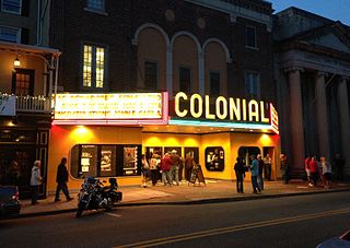
Phoenixville is a borough in Chester County, Pennsylvania, United States. It is located 28 miles (45 km) northwest of Philadelphia at the junction of French Creek and the Schuylkill River. It is in the Philadelphia metropolitan area. According to a 2022 estimate, the population was 19,354.
Audubon is a census-designated place (CDP) in Lower Providence Township, Montgomery County, Pennsylvania, United States. It was named for naturalist John James Audubon, who lived there as a young man. The population was 8,433 at the 2010 census.
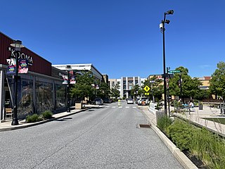
King of Prussia is a census-designated place in Upper Merion Township in Montgomery County, Pennsylvania, United States. As of the 2020 census, its population was 22,028.

Plymouth Meeting is a census-designated place (CDP) that straddles Plymouth and Whitemarsh Townships in Montgomery County, Pennsylvania, United States. The settlement was founded in 1686.
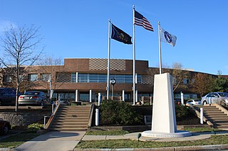
Upper Merion Township is a township in Montgomery County, Pennsylvania. The population was 33,613 at the 2020 U.S. Census. Located 16 miles (26 km) from Philadelphia, it consists of the villages of Gulph Mills, King of Prussia, Swedeland, Swedesburg, and portions of Radnor, and Wayne.

The Schuylkill River is a river in eastern Pennsylvania. It flows for 135 miles (217 km) from Pottsville southeast to Philadelphia, where it joins the Delaware River as one of its largest tributaries.

The Schuylkill Expressway, locally known as "the Schuylkill", is a freeway through southern Montgomery County and Philadelphia. It is the easternmost segment of Interstate 76 (I-76) in the U.S. state of Pennsylvania. It extends from the Valley Forge interchange of the Pennsylvania Turnpike in King of Prussia, paralleling its namesake Schuylkill River for most of the route, southeast to the Walt Whitman Bridge over the Delaware River in South Philadelphia. It serves as the primary corridor into Philadelphia from points west. Maintenance and planning for most of the highway are administered through Pennsylvania Department of Transportation (PennDOT) District 6, with the Delaware River Port Authority (DRPA) maintaining the approach to the Walt Whitman Bridge.

U.S. Route 422 (US 422) is a 271-mile-long (436 km) spur route of US 22 split into two segments in the U.S. states of Ohio and Pennsylvania. The western segment of US 422 runs from downtown Cleveland, Ohio, east to Ebensburg, Pennsylvania. The eastern segment, located entirely within Pennsylvania, runs from Hershey east to King of Prussia, near Philadelphia. US 422 Business serves as a business route into each of four towns along the way.

Pennsylvania Route 363 (PA 363) is a state highway located in Montgomery County, Pennsylvania that is a spur of PA 63. The route runs 11.96 mi (19.25 km) from an interchange with U.S. Route 422 (US 422) in Audubon northeast to an intersection with PA 63 in Lansdale. The route runs mostly through suburban areas of central Montgomery County, passing some farmland in Worcester Township. PA 363 is designated along Trooper Road, Ridge Pike, Park Avenue, and Valley Forge Road. In the community of Worcester, the route crosses PA 73.

William Penn State Forest is a Pennsylvania State Forest in Pennsylvania Bureau of Forestry District #17. The main offices are located in Elverson in Chester County, Pennsylvania in the United States.
Oaks is an unincorporated community located in Upper Providence Township, Montgomery County, Pennsylvania, United States. The community is 18 miles (30 km) northwest of Philadelphia and its boundaries are defined in large part by the village's position at the junction of Perkiomen Creek and the Schuylkill River.

The Schuylkill River Trail is a multi-use trail along the banks of the Schuylkill River in southeastern Pennsylvania. Partially complete as of 2018, the trail is ultimately planned to run about 140 miles (230 km) from the river's headwaters in Schuylkill County to Fort Mifflin in Philadelphia.

Pennsylvania Route 23 is an 81.14-mile-long (130.58 km) state highway in southeastern Pennsylvania. The route begins at PA 441 in Marietta and heads east to U.S. Route 1 at City Avenue on the border of Lower Merion Township and Philadelphia. PA 23 begins at Marietta in Lancaster County and continues east to Lancaster, where it passes through the city on a one-way pair of streets and intersects US 222 and US 30.

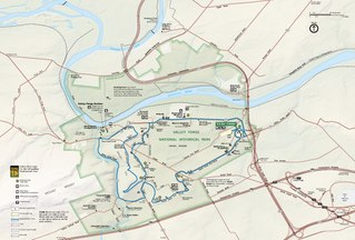
Washington's Headquarters at Valley Forge, also known as the Isaac Potts House, is a historic house that served as General George Washington's headquarters at Valley Forge during the American Revolutionary War. The building, which still stands, is one of the centerpieces of Valley Forge National Historical Park in Southeastern Pennsylvania.

Valley Forge was the winter encampment of the Continental Army, under the command of George Washington, during the American Revolutionary War. The Valley Forge encampment lasted six months, from December 19, 1777 to June 19, 1778. It was the third and harshest of the eight winter encampments that Washington and the Continental Army endured during the war.
The Great Valley is a west-to-east valley through the center of Chester County, Pennsylvania, United States. It is also sometimes referred to as Chester Valley, and both names are in use throughout the region. The valley stretches from the Schuylkill River in Montgomery County in the east, southwesterly through Chester and Lancaster counties. The valley is most distinct in central Chester County, although traces of it can be followed almost the entire distance between the Delaware and Susquehanna rivers.

Port Kennedy was an industrial village located where U.S. Route 422 now crosses the Schuylkill River in Upper Merion Township, Montgomery County, Pennsylvania, United States.

The Swatara Furnace is a historic iron furnace and 200-acre national historic district located along Mill Creek, a tributary of the Swatara Creek in Pine Grove Township, Schuylkill County, Pennsylvania.

Spring Mill is an unincorporated community in Whitemarsh Township, Montgomery County, Pennsylvania, United States.


