
Chester County is a county in the Commonwealth of Pennsylvania. It is located in the Delaware Valley region, located in the southeastern part of the state. As of the 2020 census, the population was 534,413, increasing by 7.1% from 498,886 in 2010. The county seat and most populated municipality is West Chester. Chester County was one of the three original Pennsylvania counties created by William Penn in 1682. It was named for Chester, England.

East Goshen Township is a township in Chester County, Pennsylvania, United States. The population was 18,026 at the 2010 census.
East Whiteland Township is a township in Chester County, Pennsylvania, United States. The population was 13,913 at the 2020 Census. Mailing addresses associated with East Whiteland include Malvern, Frazer, and a small area of Exton.

Exton is a census-designated place (CDP) in West Whiteland Township in Chester County, Pennsylvania, United States. Its population was 5,622 at the 2020 census. The Exton Square Mall and Main Street at Exton are both located within Exton along with several other shopping centers, making Exton the major shopping district in Chester County.
Malvern is a borough in Chester County, Pennsylvania, United States. Malvern is the terminus of the Philadelphia Main Line. It is 19.4 miles (31.2 km) west of Philadelphia. The population was 3,419 at the 2020 census.

Uwchlan Township is a township in Chester County, Pennsylvania, United States. The population was 19,161 at the 2020 census.

West Chester is a borough and the county seat of Chester County, Pennsylvania, United States. Located within the Philadelphia metropolitan area, the borough had a population of 18,461 at the 2010 census. West Chester is the mailing address for most of its neighboring townships. When calculated by mailing address, the population as of the 2010 U.S. Census was 108,696, which would make it the 10th largest city by mailing address in the state of Pennsylvania.

West Whiteland Township is a township in Chester County, Pennsylvania, United States. The population was 19,632 at the 2020 census.
Willistown Township is a township in Chester County, Pennsylvania, United States. The population was 10,497 at the 2010 census. At the 1860 census, the population of Willistown was 1,521, and in 1980 it was 8,269.

Pennsylvania Route 100 is a 59.4-mile (95.6 km) long state highway in the U.S. state of Pennsylvania that runs from U.S. Route 202 near West Chester north to PA 309 in Pleasant Corners. The route runs between the western suburbs of Philadelphia and the Lehigh Valley region of the state, serving Chester, Montgomery, Berks, and Lehigh counties. PA 100 intersects several important highways, including US 30 in Exton, the Pennsylvania Turnpike (Interstate 76, near Lionville, US 422 near Pottstown, US 222 in Trexlertown, and I-78/US 22 in Fogelsville. Several sections of PA 100 are multi-lane divided highway with some interchanges, including between US 202 and the Pennsylvania Turnpike in Chester County between south of Pottstown and New Berlinville, and between Trexlertown and Fogelsville.

U.S. Route 30 (US 30) is a U.S. Highway that runs east–west across the southern part of Pennsylvania, passing through Pittsburgh and Philadelphia on its way from the West Virginia state line east to the Benjamin Franklin Bridge over the Delaware River into New Jersey.

The Church Farm School (CFS) is a private secondary Christian school in Exton, Pennsylvania, United States. In 1985, the campus was listed as a historic district by the National Register of Historic Places.

The West Chester Area School District serves the borough and surrounding townships of West Chester, Pennsylvania, United States. The other parts include the surrounding townships of East Bradford, East Goshen, Thornbury, West Goshen, West Whiteland, and Westtown, all in Chester County, as well as Thornbury Township in adjacent Delaware County. The WCASD consists of eleven elementary schools, three middle schools, and three high schools, as of the fall 2022 school year. Elementary schools include grades 1-5, middle schools grades 6-8, and high schools grades 9-12.

Exton Square Mall is a shopping mall located in the Exton, Pennsylvania in West Whiteland Township in Chester County, Pennsylvania. The mall features a parking garage and food court. It is located at the crossroads of Chester County at the intersection of U.S. Route 30 Business and Pennsylvania Route 100. The mall is anchored by Macy's and Boscov's retail stores and a Round One Entertainment, an arcade and bowling center. It also contains dozens of smaller stores and a food court.
The Great Valley is a west-to-east valley through the center of Chester County, Pennsylvania, United States. It is also sometimes referred to as Chester Valley, and both names are in use throughout the region. The valley stretches from the Schuylkill River in Montgomery County in the east, southwesterly through Chester and Lancaster counties. The valley is most distinct in central Chester County, although traces of it can be followed almost the entire distance between the Delaware and Susquehanna rivers.
U.S. Route 30 Business is a 19-mile (31 km) business route of US 30 in Chester County, Pennsylvania. The route follows the former alignment of US 30 between Sadsbury Township and East Whiteland Township, passing through Coatesville, Downingtown, and Exton. US 30 follows a freeway bypass between these two points. The present alignment of US 30 Bus. was originally part of a turnpike called the Philadelphia and Lancaster Turnpike that was completed in 1794. The state took over the turnpike at the beginning of the 20th century. In 1913, present-day US 30 Bus. was incorporated into the Lincoln Highway, an auto trail that ran from San Francisco east to New York City. The Lincoln Highway through Pennsylvania became Pennsylvania Route 1 (PA 1) in 1924. US 30 was designated concurrent with PA 1 west of Philadelphia in 1926, with the PA 1 designation removed two years later. US 30 was widened into a multilane road through Chester County in the 1930s. In the 1960s, US 30 was moved to a freeway bypass around Coatesville and Downingtown, with US 30 Bus. designated onto the former alignment of US 30. In 1995, US 30 Bus. was extended east when US 30 was extended to bypass Exton.

U.S. Route 202 is a US Highway running from New Castle, Delaware, northeast to Bangor, Maine. The route runs through the southeastern part of the U.S. state of Pennsylvania, passing through the western and northern suburbs of Philadelphia in the Delaware Valley metropolitan area. US 202 serves largely as a toll-free bypass around the city, avoiding the busy traffic and congestion on Interstate 95 (I-95). It is signed north–south and follows a general southwest–northeast direction through the state, serving West Chester, King of Prussia, Bridgeport, Norristown, Montgomeryville, Doylestown, and New Hope. US 202 enters Pennsylvania from Delaware and heads north as a divided highway, where it becomes concurrent with US 322 at an intersection with US 1 in Painters Crossing. The two routes run north and become a freeway that bypasses West Chester to the east, with US 322 splitting from US 202. US 202 continues north and east along the freeway to King of Prussia, where it reverts to an at-grade divided highway following an interchange with I-76. The route becomes a one-way pair as it passes through Bridgeport and Norristown before both directions rejoin and the road continues northeast. US 202 follows an expressway-grade parkway between Montgomeryville and Doylestown prior to bypassing Doylestown to the south along a freeway. The route continues northeast as an at-grade road to New Hope, where it turns into a freeway again before it crosses the Delaware River on the New Hope–Lambertville Toll Bridge into New Jersey.

St. Paul's Episcopal Church, Exton, also known as St. Paul's Church, is a historic church at 1105 E. Lincoln Highway in Exton, Pennsylvania in Chester County, Pennsylvania, in the area known as the Great Valley. It was built in 1828 and added to the National Register of Historic Places in 1984 as St. Paul's Church. It is one of the 155 parish churches of the Episcopal Diocese of Pennsylvania.
Several special routes of U.S. Route 30 exist. In order from west to east they are as follows.

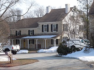
The Whitford Lodge is a historic building located in Exton in West Whiteland Township, Pennsylvania, in the Philadelphia metropolitan area. Politician and soldier Richard Thomas constructed the lodge in 1782. It is one of three surviving historic residences constructed by Thomas in West Whiteland Township, the others being Whitford Hall and Ivy Cottage.


