Eagleview, Pennsylvania

Last updated

Eagleview, Pennsylvania
EagleviewPA.jpg
Wharton Boulevard and Cricket Lane in Eagleview
Chester County Pennsylvania incorporated and unincorporated areas Eagleview highlighted.svg
Location in Chester County and the state of Pennsylvania
Coordinates: 40°3′41″N75°40′31″W / 40.06139°N 75.67528°W / 40.06139; -75.67528
Country United States
State Pennsylvania
County Chester
Township Uwchlan
Area
[1]
  Total1.35 sq mi (3.51 km2)
  Land1.34 sq mi (3.47 km2)
  Water0.01 sq mi (0.04 km2)
Elevation
450 ft (140 m)
Population
 (2020) [2]
  Total2,193
  Density1,635.35/sq mi (631.23/km2)
Time zone UTC-5 (Eastern (EST))
  Summer (DST) UTC-4 (EDT)
ZIP Code
19403
Area code(s) 610
FIPS code 42-20662

Eagleview is a census-designated place (CDP) in Uwchlan Township, Chester County, Pennsylvania, United States. The population was 1,644 at the 2010 census. [3]

Contents

Eagleview was created as "... an old fashion town where you can work, live, shop, see your elders, and care for the young all in the same place." [4] According to a Landsat imagery, the Eagleview shopping center represents a medium density development that generated 400 square feet more living space per acre per the source than lower density developments also shown in the same imagery. [5] Stevens, in his book on a study of how to make communities safer in new urban developments uses Eagleview, along with Weatherstone, as sample data for comparing amount of green space for every acreage of development. [6] The community was listed in volume 6 of the New Urban News as an example of this new type of housing development. [7]

The shopping district inside the census designated place of the same name contains a mixed use community of stores, restaurants, and residential units with "walkable streets" and green spaces according to the official website. [8]

Geography

Eagleview Town Center EagleviewParkPA.jpg
Eagleview Town Center

Eagleview is located at 40°3′41″N75°40′31″W / 40.06139°N 75.67528°W / 40.06139; -75.67528 [9] along the northwest border of Uwchlan Township. Pennsylvania Route 100, also known as Pottstown Pike, forms the northeastern edge of Eagleview, including Route 100's connection to Exit 312 of the Pennsylvania Turnpike. According to the U.S. Census Bureau, Eagleview has a total area of 1.4 square miles (3.5 km2), all land. [10]

Historical population
CensusPop.Note
2020 2,193
U.S. Decennial Census [11]

See also

Related Research Articles

<span class="mw-page-title-main">Lionville, Pennsylvania</span> Census-designated place in Pennsylvania, United States

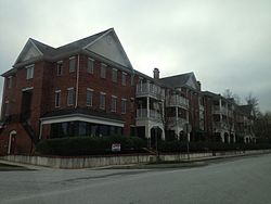
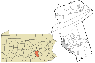
Lionville is a census-designated place (CDP) in Uwchlan Township, Chester County, Pennsylvania, United States. The population was 6,189 at the 2010 census. Prior to 2010 the CDP was recorded as Lionville-Marchwood. "Marchwood", however, refers only to the housing development begun in the early 1960s that is located south of the 100-113 intersection.

<span class="mw-page-title-main">Uwchlan Township, Pennsylvania</span> Township in Pennsylvania, United States

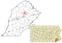
Uwchlan Township is a township in Chester County, Pennsylvania, United States. The population was 19,161 at the 2020 census.

<span class="mw-page-title-main">West Vincent Township, Pennsylvania</span> Township in Pennsylvania, United States

West Vincent Township is a township in Chester County, Pennsylvania, United States. The population was 4,567 at the 2010 census.

<span class="mw-page-title-main">Colonial Park, Pennsylvania</span> Census-designated place in Pennsylvania, United States

Colonial Park is an unincorporated community and census-designated place (CDP) in Lower Paxton Township, Pennsylvania, United States. The population was 13,229 at the 2010 census. It is part of the Harrisburg–Carlisle Metropolitan Statistical Area. It uses the Harrisburg ZIP code of 17109 and hosts a great deal of the area's retail activity, including the Colonial Park Mall.

<span class="mw-page-title-main">Nuremberg, Pennsylvania</span> Census-designated place in Pennsylvania, United States

Nuremberg is a census-designated place (CDP) that is located in Schuylkill and Luzerne counties, Pennsylvania, United States. The population was 434 at the time of the 2010 census.

<span class="mw-page-title-main">Berwyn, Pennsylvania</span> Census-designated place in Pennsylvania, United States

Berwyn is a census-designated place (CDP) in Chester County, Pennsylvania, United States. Berwyn is located within Tredyffrin and Easttown Townships. The area is part of the Philadelphia Main Line suburbs.

<span class="mw-page-title-main">Devon, Pennsylvania</span> Census-designated place in Pennsylvania, United States

Devon is a census-designated place (CDP) located in Easttown township in Chester County, Pennsylvania, United States. The population was 1,515 at the 2010 census. The area is part of the Philadelphia Main Line suburbs.

Trucksville is a census-designated place (CDP) in Kingston Township, Luzerne County, Pennsylvania, United States. The population was 2,152 at the 2010 census.

Pardeesville is a census-designated place (CDP) in Hazle Township, Luzerne County, Pennsylvania, United States. The population was 572 at the 2010 census.

<span class="mw-page-title-main">Harleigh, Pennsylvania</span> Census-designated place in Pennsylvania, United States

Harleigh is a census-designated place (CDP) in Hazle Township, Luzerne County, Pennsylvania, United States, north of the city of Hazleton. The CDP population was 1,104 at the 2010 census.

<span class="mw-page-title-main">Palmdale, Pennsylvania</span> Census-designated place in Pennsylvania, United States

Palmdale is an unincorporated community and census-designated place (CDP) in Derry Township, Dauphin County, Pennsylvania, United States. As of the 2010 census the population was 1,308. Palmdale is in the Harrisburg–Carlisle metropolitan statistical area.

Browntown is a census-designated place (CDP) in Pittston Township, Luzerne County, Pennsylvania, United States, adjacent to Pittston City. The CDP population was 1,418 at the 2010 census.

<span class="mw-page-title-main">Georgetown, Luzerne County, Pennsylvania</span> Census-designated place in Pennsylvania, United States

Georgetown is a census-designated place (CDP) in Wilkes-Barre Township, Luzerne County, Pennsylvania, United States, adjacent to the city of Wilkes-Barre. The CDP population was 1,640 at the 2010 census.

Hilldale is a census-designated place (CDP) in Plains Township, Luzerne County, Pennsylvania, United States. The population was 1,246 at the time of the 2010 census.

Hudson is a census-designated place (CDP) in Plains Township, Luzerne County, Pennsylvania, United States. The population was 1,443 at the 2010 census.

<span class="mw-page-title-main">Mocanaqua, Pennsylvania</span> Census-designated place in Pennsylvania, United States

Mocanaqua is an unincorporated community and census-designated place (CDP) in Conyngham Township, Luzerne County, Pennsylvania, United States. The population was 646 at the 2010 census.

<span class="mw-page-title-main">Weston, Pennsylvania</span> Census-designated place in Pennsylvania, United States

Weston is a census-designated place (CDP) in Black Creek Township, Luzerne County, Pennsylvania, United States. The population was 321 at the 2010 census.

<span class="mw-page-title-main">Caln, Pennsylvania</span> Census-designated place in Pennsylvania, United States

Caln is a census-designated place (CDP) in Caln Township, Chester County, Pennsylvania, United States. The population was 1,519 at the 2010 census. It is located east of the city of Coatesville and lies west of Philadelphia.

<span class="mw-page-title-main">Bressler, Pennsylvania</span> Census-designated place in Pennsylvania, United States

Bressler is an unincorporated community and census-designated place (CDP) located in Swatara Township, Dauphin County, in the U.S. state of Pennsylvania. The community was formerly part of the census-designated place of Bressler-Enhaut-Oberlin, before splitting into three separate CDPs for the 2010 census. As of the 2010 census the population of Bressler was 1,437.

<span class="mw-page-title-main">Enhaut, Pennsylvania</span> Census-designated place in Pennsylvania, United States

Enhaut is an unincorporated community and census-designated place (CDP) located in Swatara Township, Dauphin County, Pennsylvania, United States. The community was formerly part of the census-designated place of Bressler-Enhaut-Oberlin, before splitting into three separate CDPs for the 2010 census. As of the 2010 census, the population in Enhaut was 1,007.

References

  1. "ArcGIS REST Services Directory". United States Census Bureau. Retrieved October 12, 2022.
  2. "Census Population API". United States Census Bureau. Retrieved October 12, 2022.
  3. "Profile of General Population and Housing Characteristics: 2010 Demographic Profile Data (DP-1): Eagleview CDP, Pennsylvania". United States Census Bureau . Retrieved August 20, 2012.
  4. Harriet Hankin (2005). The New Workforce: Five Sweeping Trends That Will Shape Your Company's Future. ISBN   9780814428474.
  5. Qihao Weng (October 3, 2007). Remote Sensing of Impervious Surfaces. ISBN   9781420043754.
  6. Mark Robert Stevens. Can Individual Planners Make Communities Safer? A Study of the Use of ... ISBN   9780549533023.
  7. New Urban News - Volume 6 - Page 112. 2001.
  8. The Hankin Group. "Eagleview Town Center". Archived from the original on April 9, 2013. Retrieved June 5, 2013.
  9. US Geological Survey 7.5 minute topographic map series
  10. "Geographic Identifiers: 2010 Demographic Profile Data (G001): Eagleview CDP, Pennsylvania". United States Census Bureau . Retrieved August 20, 2012.
  11. "Census of Population and Housing". Census.gov. Retrieved June 4, 2016.