Bernville is a borough in Berks County, Pennsylvania. The population was 955 at the 2010 census. Bernville is bordered by Penn Township to the north, east, and south and by Jefferson Township to the west.

East Pikeland Township is a township in Chester County, Pennsylvania, United States. The population was 7,079 at the 2010 census.

Upper Uwchlan Township is a township in Chester County, Pennsylvania. The population was 11,227 at the 2010 census. The township included the community of Milford Mills before it was inundated by the creation of the Marsh Creek Dam in 1972.

Uwchlan Township is a township in Chester County, Pennsylvania, United States. The population was 19,161 at the 2020 census.

Brandywine Creek is a tributary of the Christina River in southeastern Pennsylvania and northern Delaware in the United States. The Lower Brandywine is 20.4 miles (32.8 km) long and is a designated Pennsylvania Scenic River with several tributary streams. The East Branch and West Branch of the creek originate within 2 miles (3 km) of each other on the slopes of Welsh Mountain in Honey Brook Township, Pennsylvania, about 20 miles (32 km) northwest of their confluence.

Darby Creek is a tributary of the Delaware River in Chester, Delaware and Philadelphia counties, in the U.S. Commonwealth of Pennsylvania. It is approximately 26 miles (42 km) long. The watershed of the creek has an area of 77.2 square miles (200 km2). It has twelve named direct tributaries, including Cobbs Creek, Little Darby Creek, Ithan Creek, and Muckinipattis Creek. The creek has a low level of water quality for most of its length. The lower Darby Creek area was deemed a Superfund site by the U.S. Environmental Protection Agency (EPA) due to contamination with dangerous chemicals from two landfills.

Pennsylvania Route 100 is a 59.4-mile (95.6 km) long state highway in the U.S. state of Pennsylvania that runs from U.S. Route 202 near West Chester north to PA 309 in Pleasant Corners. The route runs between the western suburbs of Philadelphia and the Lehigh Valley region of the state, serving Chester, Montgomery, Berks, and Lehigh counties. PA 100 intersects several important highways, including US 30 in Exton, the Pennsylvania Turnpike (Interstate 76, near Lionville, US 422 near Pottstown, US 222 in Trexlertown, and I-78/US 22 in Fogelsville. Several sections of PA 100 are multi-lane divided highway with some interchanges, including between US 202 and the Pennsylvania Turnpike in Chester County between south of Pottstown and New Berlinville, and between Trexlertown and Fogelsville.

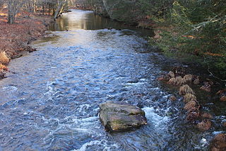
Tohickon Creek is a 29.5-mile-long (47.5 km) tributary of the Delaware River. Located entirely in Bucks County, in southeastern Pennsylvania, it rises in Springfield Township and has its confluence with the Delaware at Point Pleasant. It is dammed to form Lake Nockamixon.

Pennsylvania Route 29 is a 118-mile-long (190 km) north–south state highway that runs through most of eastern Pennsylvania.

Wawa is an unincorporated community located in Delaware County, in the U.S. state of Pennsylvania in Greater Philadelphia, partially in Middletown Township and partially in Chester Heights Borough.

Chester Springs is an unincorporated community in Chester County, Pennsylvania, United States. It is centered on West Pikeland Township, and extends into Charlestown Township, Upper Uwchlan Township, Wallace Township, East Nantmeal Township, and West Vincent Township. The Chester Springs Historic District is located in Chester Springs.

Harveys Creek is a tributary of the Susquehanna River in Luzerne County, Pennsylvania, in the United States. It is approximately 14.5 miles (23.3 km) long and flows through Harveys Lake, Lake Township, Lehman Township, Jackson Township, and Plymouth Township. The creek's watershed has an area of 46.3 square miles (120 km2). The creek has four named tributaries, which are known as Bear Hollow Creek, Paint Spring Run, Pikes Creek, and East Fork Harveys Creek. The watershed is designated as a High-Quality Coldwater Fishery and a Migratory Fishery above Pikes Creek and as a Coldwater Fishery and a Migratory Fishery below it. The creek's source is Harveys Lake, the largest natural lake in Pennsylvania.
Crum Creek is a creek in Delaware County and Chester County, Pennsylvania, flowing approximately 24 miles (39 km), generally in a southward direction and draining into the Delaware River in Eddystone, Pennsylvania. It begins in a swamp near Newtown Square, Pennsylvania along which several mills were established in the 19th century. Right afterward it crosses under Pennsylvania Route 29 and winds one and a half miles (2.4 km) downstream until it hits the hamlet of Crum Creek. It later flows into the Delaware River near Philadelphia.

Octoraro Creek is a 22.1-mile-long (35.6 km) tributary of the Susquehanna River, joining it 9 miles (14 km) above the Susquehanna's mouth at Chesapeake Bay. The Octoraro rises as an East and West Branch in Pennsylvania. The East Branch and Octoraro Creek form the southern half of the border between Lancaster and Chester counties until the creek crosses the Mason-Dixon line. It winds through northwestern Cecil County, Maryland before joining the Susquehanna.

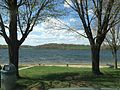
Marsh Creek State Park is a 1,705 acres (690 ha) Pennsylvania state park in Upper Uwchlan and Wallace Townships, Chester County, Pennsylvania in the United States. The park is the location of the 535-acre (217 ha) man-made Marsh Creek Lake. With an average depth of 40 feet, the lake is stocked with fish and is a stop for migrating waterfowl. Marsh Creek State Park is 2 miles (3.2 km) west of Eagle on Pennsylvania Route 100. Park road hours 8:00 am until sunset. All other access open 24 hours.
Huntington Creek is a tributary of Fishing Creek in Luzerne and Columbia counties, Pennsylvania, in the United States. It is approximately 29.5 miles (47.5 km) long.

Pennsylvania Route 252 is a north–south state highway in the U.S. state of Pennsylvania that connects PA 320 in Nether Providence Township at its southern terminus to PA 23 in Valley Forge at its northern terminus. The route runs through the western suburbs of Philadelphia in Delaware, Chester, and Montgomery counties, including Nether Providence Township, the borough of Media, Upper Providence Township, Marple Township, Newtown Township, Easttown Township, Tredyffrin Township, and Upper Merion Township. The route intersects many roads including U.S. Route 1 north of Media, PA 3 in Newtown Square, US 30 in Paoli, and US 202 near Berwyn.

Ithan Creek is a tributary of Darby Creek in Delaware County, Pennsylvania, in the United States. It is approximately 4.2 miles (6.8 km) long and flows through Radnor Township and Haverford Township. The creek's watershed has an area of 7.39 square miles (19.1 km2) and is highly developed. It has three named tributaries: Browns Run, Kirks Run, and Meadowbrook Run.

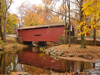
Larkin Covered Bridge is a 60-foot-long (18 m), Burr truss wooden covered bridge located outside Chester Springs, Chester County, Pennsylvania, near the village of Eagle. The bridge, which originally crossed over Marsh Creek, now spans a dry ditch and is a feature of the Upper Uwchlan Township trail system.
Mill Creek is a 11.04 miles (17.77 km) long tributary of the Delaware River and is one of six streams in Bucks County, Pennsylvania by the same name. Mill Creek rises just east of Core Creek Park in Middletown Township and reaches its confluence at the Delaware River's 118.87 river mile in Bristol Borough.