
A Chinatown is an ethnic enclave of Chinese people located outside mainland China, Hong Kong, Macau or Taiwan, most often in an urban setting. Areas known as "Chinatown" exist throughout the world, including Europe, North America, South America, Asia, Africa, Australasia and the Middle East.

Philadelphia, known colloquially as Philly, is the largest city in the U.S. state and Commonwealth of Pennsylvania, and the sixth-most populous U.S. city with a 2018 census-estimated population of 1,584,138. Since 1854, the city has had the same geographic boundaries as Philadelphia County, the most populous county in Pennsylvania and the urban core of the eighth-largest U.S. metropolitan statistical area, with over 6 million residents as of 2017. Philadelphia is also the economic and cultural anchor of the greater Delaware Valley, located along the lower Delaware and Schuylkill Rivers, within the Northeast megalopolis. The Delaware Valley's population of 7.2 million ranks it as the eighth-largest combined statistical area in the United States.
A gay village is a geographical area with generally recognized boundaries, inhabited or frequented by many lesbian, gay, bisexual, and transgender (LGBT) people. Gay villages often contain a number of gay-oriented establishments, such as gay bars and pubs, nightclubs, bathhouses, restaurants, boutiques and bookstores.

The French Quarter, also known as the Vieux Carré and Barrio Francés, is the oldest neighborhood in the city of New Orleans. After New Orleans was founded in 1718 by Jean-Baptiste Le Moyne de Bienville, the city developed around the Vieux Carré, a central square. The district is more commonly called the French Quarter today, or simply "The Quarter," related to changes in the city with American immigration after the 1803 Louisiana Purchase. Most of the extant historic buildings were constructed either in the late 18th century, during the city's period of Spanish rule, or were built during the first half of the 19th century, after U.S. annexation and statehood.
WHYY-TV, virtual and VHF digital channel 12, is a Public Broadcasting Service (PBS) member television station serving Philadelphia, Pennsylvania, United States that is licensed to Wilmington, Delaware. Owned by WHYY, Inc., it is sister to National Public Radio (NPR) member station WHYY-FM (90.9). The two stations share studios on Independence Mall in Center City, Philadelphia and transmitter facilities in the city's Roxborough section; WHYY-TV also operates a secondary studio in Wilmington. It is one of three PBS member stations serving the Philadelphia market, alongside Allentown-based WLVT-TV and NJTV.
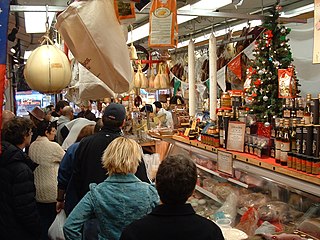
The Italian Market is the popular name for the South 9th Street Curb Market, an area of South Philadelphia featuring awning covered sidewalks, curb carts, grocery shops, cafes, restaurants, bakeries, cheese shops, butcher shops, etc., many with an Italian influence. The historical heart of the market is the area of 9th Street between Christian Street and Washington Avenue, the commercial district chartered in 1915, the South Ninth Street Business Men's Association, covered the area between Catharine to Federal and Eighth to Tenth streets, and the market is now generally considered to extend from Fitzwater Street at the north to Wharton Street at the south. The term Italian Market is also used to generally describe the surrounding neighborhood between South Street to the North and Wharton Street to the South running a few blocks to the east and west of 9th street.
Interstate 676 (I-676) is an Interstate Highway that serves as a major thoroughfare through Center City Philadelphia, where it is known as the Vine Street Expressway, and Camden, New Jersey, where it is known as the northern segment of the North–South Freeway, as well as the Martin Luther King Jr. Memorial Highway. Its western terminus is at I-76 in Philadelphia near the Philadelphia Museum of Art and Fairmount Park. From there it heads east and is then routed on surface streets near Franklin Square and Independence Mall, home of the Liberty Bell, before crossing the Ben Franklin Bridge. On the New Jersey side of the bridge, the highway heads south to its southern terminus at I-76 in Gloucester City near the Walt Whitman Bridge. Between the western terminus and downtown Camden, I-676 is concurrent with U.S. Route 30.
Washington Square West is a neighborhood in downtown, or Center City, Philadelphia, Pennsylvania. The neighborhood roughly corresponds to the area between 7th and Broad Streets and between Chestnut and South Streets, bordering on the Independence Mall tourist area directly northeast, Market East to the northwest, Old City and Society Hill to the East, Bella Vista directly south, Hawthorne to the southwest, and mid-town Philadelphia and Rittenhouse Square to the west. In addition to being a desirable residential community, it is considered a hip, trendy neighborhood that offers a diverse array of shops, restaurants, and coffee houses. Washington Square West contains many gay-friendly establishments and hosts annual events celebrating LGBT culture in Philadelphia including OutFest. The area takes its name from Washington Square, a historic urban park in the northeastern corner of the neighborhood.

Fishtown is a neighborhood in Philadelphia, Pennsylvania, United States. Located immediately northeast of Center City, its borders are somewhat disputed today due to many factors, but are roughly defined by the triangle created by the Delaware River, Frankford Avenue, and York Street. Some newer residents expand the area to Lehigh Avenue, while some older residents shrink the area to Norris Street. It is served by the Market–Frankford Line rapid transit subway/elevated line of the SEPTA system. Fishtown is known as a working class Irish Catholic neighborhood. Recently, however, the neighborhood has seen a large influx of young urban professionals and gentrification.

Saint Laurent Boulevard also known as Saint Lawrence Boulevard is a major street in Montreal, Quebec, Canada. A commercial artery and cultural heritage site, the street runs north-south through the near-centre of city and is nicknamed The Main which is the abbreviation for "Main Street".

Center City includes the central business district and central neighborhoods of Philadelphia, in the U.S. state of Pennsylvania. It comprises the area that made up the City of Philadelphia prior to the Act of Consolidation, 1854 which extended the city borders to be coterminous with Philadelphia County. Greater Center City has grown into the second-most densely populated downtown area in the United States, after Midtown Manhattan in New York City, with an estimated 193,000 residents in 2018.

Strawberry Mansion is a neighborhood in the United States city of Philadelphia, Pennsylvania, located east of Fairmount Park in North Philadelphia. The neighborhood is bounded by 33rd Street to the west, 29th Street to the east, Lehigh Avenue to the north, and Oxford Street to the south. As of the 2000 census, the neighborhood had a population of 22,562. It is often associated with the historic house of the same name, Historic Strawberry Mansion, located adjacent to the neighborhood and generally thought to be the source of the community's name.

The Avenue of the Arts is a city designated arts cultural district on a segment of Broad Street in Philadelphia, Pennsylvania, that includes many of the city's cultural institutions, most notably the theater district south of City Hall. The designation can be found as far south as Washington Avenue and as far north as the Cecil B. Moore neighborhood.

Fairhill is a neighborhood on the east side of the North Philadelphia section of Philadelphia, Pennsylvania, United States. Fairhill is bordered by Front Street to the east, Germantown Avenue to the west, Allegheny Avenue to the north, and Cumberland Street to the south. The neighborhood serves as the center of the Hispanic community of Philadelphia, and is known for its "El Centro de Oro" commercial strip along North 5th Street. The neighborhood is also the center of the Philadelphia Badlands. Fairhill is adjacent to Harrowgate and West Kensington to the east, Hartranft to the south, Glenwood to the west, and Hunting Park to the north.

Pennsylvania Route 291 is an east–west route in Pennsylvania that runs from U.S. Route 13 in Trainer, Delaware County east to Interstate 76 (I-76) in South Philadelphia near the Walt Whitman Bridge and the South Philadelphia Sports Complex. Except for a short 1-mile (1.6 km) section between US 13 and the Chester/Trainer line, PA 291 is mostly a four-lane highway. It runs parallel to the Delaware River. The route passes through industrial areas near the river in Delaware County, serving Chester, Eddystone, Essington, and Lester. PA 291 enters Philadelphia near the Philadelphia International Airport, at which point it has an interchange with I-95. The route crosses the Schuylkill River on the George C. Platt Memorial Bridge and continues along Penrose Avenue to I-76. It has been designated the Industrial Heritage Highway.

N3RD Street is a nickname for a segment of North 3rd Street in Philadelphia, between Market Street and Girard Avenue, and its surrounding community that is home to a concentration of "nerdy" companies and spaces; "N3RD" is a double entendre as both leet for "nerd" and reflecting the "N. 3rd St." of postal addresses.

The development of LGBT culture in Philadelphia can be traced back to the early 20th century. It exists in current times as a dynamic and diverse culture with establishments and events held to promote LGBT culture and rights in Philadelphia and beyond.
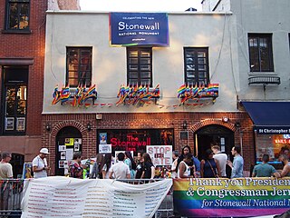
Stonewall National Monument is a 7.7-acre (3.1 ha) U.S. National Monument in the West Village neighborhood of Greenwich Village in Lower Manhattan, New York City. The designated area includes the 0.19-acre (0.077 ha) Christopher Park and the block of Christopher Street bordering the park, which is directly across the street from the Stonewall Inn—the site of the Stonewall riots of June 28, 1969, widely regarded as the start of the modern LGBT rights movement in the United States.

Fabric Row is a historic Jewish textile and garment district located on South 4th Street in the Queen Village neighborhood of Philadelphia between Bainbridge Street and Catherine Street.

