
Schuylkill Haven is a borough in Schuylkill County, Pennsylvania, United States. The borough's population was 5,253 as of the 2020 census. Schuylkill Haven is situated along the Schuylkill River, for which it is named. Schuylkill Haven is a focal point of activity in southern Schuylkill County.

The Schuylkill River is a river in eastern Pennsylvania. It flows for 135 miles (217 km) from Pottsville southeast to Philadelphia, where it joins the Delaware River as one of its largest tributaries.

Interstate 676 (I-676) is an Interstate Highway that serves as a major thoroughfare through Center City Philadelphia, where it is known as the Vine Street Expressway, and Camden, New Jersey, where it is known as the northern segment of the North–South Freeway, as well as the Martin Luther King Jr. Memorial Highway in honor of civil rights leader Martin Luther King Jr. Its western terminus is at I-76 in Philadelphia near the Philadelphia Museum of Art and Fairmount Park. From there, it heads east and is then routed on surface streets near Franklin Square and Independence National Historical Park, home of the Liberty Bell, before crossing the Delaware River on the Benjamin Franklin Bridge. On the New Jersey side of the bridge, the highway heads south to its southern terminus at I-76 in Gloucester City near the Walt Whitman Bridge. Between the western terminus and downtown Camden, I-676 is concurrent with U.S. Route 30 (US 30).

Transportation in Philadelphia involves the various modes of transport within the city and its required infrastructure. In addition to facilitating intracity travel, Philadelphia's transportation system connects Philadelphia to towns of its metropolitan area and surrounding areas within the Northeast megalopolis.

Interstate 76 (I-76) is an east–west Interstate Highway in the Eastern United States. The highway runs approximately 435.66 miles (701.13 km) from an interchange with I-71 west of Akron, Ohio, east to I-295 in Bellmawr, New Jersey. This route is not contiguous with I-76 in Colorado and Nebraska.

West Philadelphia, nicknamed West Philly, is a section of the city of Philadelphia. Although there are no officially defined boundaries, it is generally considered to reach from the western shore of the Schuylkill River, to City Avenue to the northwest, Cobbs Creek to the southwest, and the SEPTA Media/Wawa Line to the south. An alternate definition includes all city land west of the Schuylkill; this would also include Southwest Philadelphia and its neighborhoods. The eastern side of West Philadelphia is also known as University City.

The Main Line of Public Works was a package of legislation passed by the Commonwealth of Pennsylvania in 1826 to establish a means of transporting freight between Philadelphia and Pittsburgh. It funded the construction of various long-proposed canal and road projects, mostly in southern Pennsylvania, that became a canal system and later added railroads. Built between 1826 and 1834, it established the Pennsylvania Canal System and the Allegheny Portage Railroad.
The Schuylkill Expressway, locally known as "the Schuylkill", is a freeway through southern Montgomery County and Philadelphia. It is the easternmost segment of Interstate 76 (I-76) in the U.S. state of Pennsylvania. It extends from the Valley Forge interchange of the Pennsylvania Turnpike in King of Prussia, paralleling its namesake Schuylkill River for most of the route, southeast to the Walt Whitman Bridge over the Delaware River in South Philadelphia. It serves as the primary corridor into Philadelphia from points west. Maintenance and planning for most of the highway are administered through Pennsylvania Department of Transportation (PennDOT) District 6, with the Delaware River Port Authority (DRPA) maintaining the approach to the Walt Whitman Bridge.
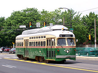
Route 15, the Girard Avenue Line, is a trolley line operated by the Southeastern Pennsylvania Transportation Authority (SEPTA) along Girard Avenue through North and West Philadelphia, Pennsylvania, United States. As of 2007, it is the only surface trolley line in the City Transit Division that is not part of the Subway–Surface Trolley Lines. SEPTA PCC II vehicles are used on the line.

East Falls is a neighborhood in Lower Northwest, Philadelphia, Pennsylvania, United States. It lies on the east bank of the "Falls of the Schuylkill," cataracts submerged in 1822 by the Schuylkill Canal and Fairmount Water Works projects. East Falls sits next to the Germantown, Roxborough, Allegheny West, and the Nicetown-Tioga neighborhoods. Wissahickon Valley Park separates it from Manayunk, Philadelphia.

U.S. Route 422 (US 422) is a 271-mile-long (436 km) spur route of US 22 split into two segments in the U.S. states of Ohio and Pennsylvania. The western segment of US 422 runs from downtown Cleveland, Ohio, east to Ebensburg, Pennsylvania. The eastern segment, located entirely within Pennsylvania, runs from Hershey east to King of Prussia, near Philadelphia. US 422 Business serves as a business route into each of four towns along the way.

Pennsylvania Route 291 is an east–west state route in Pennsylvania that runs from U.S. Route 13 and US 13 Business in Trainer, Delaware County, east to Interstate 76 (I-76) in South Philadelphia near the Walt Whitman Bridge and the South Philadelphia Sports Complex. Except for a short 1-mile (1.6 km) section between the western terminus and the Chester/Trainer line, PA 291 is mostly a four-lane highway. From the western terminus to the eastern part of Chester, the route has a concurrency with US 13. It runs parallel to the Delaware River for much of the route. The route passes through industrial areas near the river in Delaware County, serving Chester, Eddystone, Essington, and Lester. PA 291 enters Philadelphia near the Philadelphia International Airport, at which point it has an interchange with I-95. The route crosses the Schuylkill River on the George C. Platt Memorial Bridge and continues along Penrose Avenue to I-76. It has been designated the Industrial Heritage Highway.

The Schuylkill River Trail is a multi-use trail along the banks of the Schuylkill River in southeastern Pennsylvania. Partially complete as of 2018, the trail is ultimately planned to run about 140 miles (230 km) from the river's headwaters in Schuylkill County to Fort Mifflin in Philadelphia.

Pennsylvania Route 23 is an 81.14-mile-long (130.58 km) state highway in southeastern Pennsylvania. The route begins at PA 441 in Marietta and heads east to U.S. Route 1 at City Avenue on the border of Lower Merion Township and Philadelphia. PA 23 begins at Marietta in Lancaster County and continues east to Lancaster, where it passes through the city on a one-way pair of streets and intersects US 222 and US 30.

U.S. Route 1 (US 1) is a major north–south U.S. Route, extending from Key West, Florida, in the south to Fort Kent, Maine, at the Canada–United States border in the north. In the U.S. state of Pennsylvania, US 1 runs for 81 miles (130 km) from the Maryland state line near Nottingham northeast to the New Jersey state line at the Delaware River in Morrisville, through the southeastern portion of the state. The route runs southwest to northeast and serves as a major arterial road through the city of Philadelphia and for many of the suburbs in the Delaware Valley metropolitan area. South of Philadelphia, the road mostly follows the alignment of the Baltimore Pike. Within Philadelphia, it mostly follows Roosevelt Boulevard. North of Philadelphia, US 1 parallels the route of the Lincoln Highway. Several portions of US 1 in Pennsylvania are freeways, including from near the Maryland state line to Kennett Square, the bypass of Media, the concurrency with Interstate 76 and the Roosevelt Expressway in Philadelphia, and between Bensalem Township and the New Jersey state line.

Gray's Ferry Bridge has been the formal or informal name of several floating bridges and four permanent ones that have carried highway and rail traffic over the Schuylkill River in Philadelphia. The bridge today is a four-lane divided highway bridge, built in 1976, that carries Grays Ferry Avenue from the Grays Ferry neighborhood on the east bank, over the river and the Northeast Corridor railroad tracks, to the Southwest Philadelphia neighborhood of Kingsessing.

Spring Garden Street Bridge is a highway bridge in Philadelphia, Pennsylvania. It crosses the Schuylkill River below Fairmount Dam and connects West Philadelphia to the Philadelphia Museum of Art and Benjamin Franklin Parkway. It is the fourth bridge at this location.

Pennsylvania Railroad, Connecting Railway Bridge is a stone arch bridge in Philadelphia, Pennsylvania, that carries Amtrak Northeast Corridor rail lines and SEPTA and NJT commuter rail lines over the Schuylkill River. It is located in Fairmount Park, just upstream from the Girard Avenue Bridge.

The 30th Street Station District, also referred to as the 30th Street District, is a master planned urban development centered around 30th Street Station located in West Philadelphia in Philadelphia, Pennsylvania, United States. The area, if approved and built, will be home to eight modern skyscrapers or high rises ranging in heights between 405 ft and 1,200 ft with four other buildings under 400 feet. The property will be owned by Amtrak and will be a major addition to the City of Philadelphia. The project is expected to cost between seven and eleven billion dollars.


