Makkovik

Last updated

Makkovik
Maggovik [1]
Town
Offshore view of Makkovik, Labrador 4 (cropped).jpg
View of Makkovik in 2023
Canada Newfoundland and Labrador location map 2.svg
Red pog.svg
Makkovik
Location of Makkovik in Labrador
Canada location map 2.svg
Red pog.svg
Makkovik
Makkovik (Canada)
Coordinates: 55°02′51″N59°12′10″W / 55.04750°N 59.20278°W / 55.04750; -59.20278 [2]
CountryCanada
Province Newfoundland and Labrador
Region Nunatsiavut
Settled1860
IncorporatedMarch 26, 1970
Government
  Mayor (AngajukKâk)Barry Andersen
  Federal MP Yvonne Jones (L)
  Provincial MHA Lela Evans (NDP)
   Nunatsiavut Assembly memberThomas Evans
Area
[4]
  Land2.95 km2 (1.14 sq mi)
Population
 (2021) [4]
  Total365
  Density123.5/km2 (320/sq mi)
Time zone UTC−04:00 (AST)
  Summer (DST) UTC−03:00 (ADT)
Canadian Postal code
A0P 1J0
Area code 709

Makkovik (Inuit: Maggovik) is a town in Labrador in eastern Canada. It had 365 residents in 2021. The main industry is snow crabbing and there is a fishing cooperative.

Contents

Makkovik is only accessible by air or sea. [5] [6]

History

The Makkovik area has been inhabited by the Inuit since 1400 or earlier. [7]

Some early European settlers included Antoine Perrault and Jean-Baptiste Jacques, [8] French Canadian fur traders who set up trading posts at nearby Kaipokok Bay. Another early settler to the area was Charles McNeill, a fisherman from Glaston, Scotland, who married Wealtheness Metcalfe of Clarke's Beach, Newfoundland, and established a fishing post at Island Harbour. A Scottish fur trader named George Lyall settled near Island Harbour in the 1850s while a Welsh settler named Thomas Evans settled at Ben's Cove. Several Inuit families also continued to live in the region. Near the 1880s, some families of mixed European and Inuit origin from Cartwright and other areas of southern Labrador also established fishing posts near Makkovik. The later establishment of the Moravian mission in Makkovik eventually pushed many families to move from outlying posts (such as Island Harbour, Ben's Cove, Adlavik, Ailik and Tishialuk) to Makkovik itself or to Postville.

Torsten Kverna Andersen and his wife Mary Ann Thomas set up a trading post at Makkovik in 1860. Andersen was originally from Norway and had previously worked in Rigolet while his wife was from Labrador.

The Moravian Church and Mission School in 1926. Moravian Church and Mission School, Makkovik, Labrador, September 1926 Eglise morave et ecole missionnaire, Makkovik (Labrador), septembre 1926 (14096934099).jpg
The Moravian Church and Mission School in 1926.

Colonization was assured in 1896 when the Moravian Church established a mission station and residential school there. Both the mission and school were destroyed by a fire in 1948 but the economy was instilled in the 1950s by two notable events. First was the forceful resettlement to Makkovik of 150 Inuit residents of the northern communities of Nutak and Hebron. [9] [10] [11] Second was the establishment nearby of a radar warning station by the United States government. [12]

Late 20th century view of Makkovik in winter. Makkovik.png
Late 20th century view of Makkovik in winter.

In January 2012, Makkovik received notable media attention after 14-year old Burton Winters froze to death after his snowmobile broke down on the ice just outside of the community. [13] [14]

The population is mainly composed of residents of mixed European and Inuit heritage. Ninety five people in Makkovik claimed to have Norwegian ancestry in the 2016 census. [15]

United States Air Force base

For three years in the late 1950s, the United States Air Force operated a remote radar base approximately 15 km (9.3 mi) north of the settlement. Called Cape Makkovik, it was constructed between 1955 and 1957 and operated until 1961, and dismantled later in the decade. It was a "gap-filler" in the Pinetree Line set up to monitor the skies for aircraft approaching from the north. [16] [17]

Geography

The Makkovik waterfront with the Kamutik W ferry at port in the distance. Kamutik W and ashore Northern Twilight boat in Makkovik, Labrador.jpg
The Makkovik waterfront with the Kamutik W ferry at port in the distance.

The community lies at the end of a peninsula in northern Labrador about 215 km (134 mi) northeast of Happy Valley-Goose Bay. Travel is by air year round (served by Makkovik Airport) and by boat in summer. Winter travel is by snowmobile. The community is situated on a sheltered bay in a saddle between two hills. In the lee of the northernmost hill is a large copse of tall spruce trees, which is remarkable given the paucity of tree cover for miles around. Now known as the Moravian Wood, there is a small cemetery in the centre.

Demographics

In the 2021 Canadian census conducted by Statistics Canada, Makkovik had a population of 365 living in 142 of its 154 total private dwellings, a change of

Geology

The community is located in the Makkovik Province, a Paleoproterozoic accretionary belt which is the smallest defined tectonic component of the Canadian Shield. The Makkovik Province is separated from the Nain Province to the north by the Kanairiktok Shear Zone and from the Grenville Province to the south by the Grenville Front, which marks the northern limit of the widespread Grenvillian deformation. Prior to the opening of the Labrador Sea the Makkovik Province lay adjacent to the Ketilidian mobile belt which currently forms part of Southwest Greenland.

Climate

Like most of Labrador, Makkovik has a subarctic climate (Köppen Dfc) with short, mild summers and very cold winters. Typically for its region but unusually for subarctic regions generally, precipitation is high with a minimum from March to May. This high precipitation and cool summers is due to the powerful influence of the Icelandic Low and the Labrador Current on its western side, and gives very heavy snowfall of 411.6 cm (162.0 in) per year with an average maximum cover of 69 cm (27 in) during March and April. [18] The greatest snow depth was 152 cm (60 in) on April 17, 1997. [18] Unlike most places with a pronounced subarctic climate, Makkovik has a pronounced seasonal lag with August being much warmer than July and September averaging slightly warmer than June.

Climate data for Makkovik (Makkovik Airport)
Climate ID: 8502NHR; coordinates 55°04′56″N59°11′19″W / 55.08222°N 59.18861°W / 55.08222; -59.18861 (Makkovik Airport) ; elevation: 70.4 m (231 ft); 1981–2010 normals
MonthJanFebMarAprMayJunJulAugSepOctNovDecYear
Record high humidex 10.88.312.815.527.036.642.642.531.420.616.98.542.6
Record high °C (°F)12.0
(53.6)
10.0
(50.0)
13.0
(55.4)
14.0
(57.2)
28.0
(82.4)
34.5
(94.1)
33.5
(92.3)
34.5
(94.1)
29.0
(84.2)
18.5
(65.3)
16.0
(60.8)
14.0
(57.2)
34.5
(94.1)
Mean daily maximum °C (°F)−12.6
(9.3)
−12.1
(10.2)
−6.2
(20.8)
0.5
(32.9)
6.8
(44.2)
12.5
(54.5)
16.5
(61.7)
17.2
(63.0)
12.4
(54.3)
5.7
(42.3)
−1.1
(30.0)
−7.5
(18.5)
2.7
(36.8)
Daily mean °C (°F)−16.7
(1.9)
−16.5
(2.3)
−10.6
(12.9)
−3.1
(26.4)
2.8
(37.0)
7.8
(46.0)
11.6
(52.9)
12.6
(54.7)
8.6
(47.5)
2.8
(37.0)
−3.9
(25.0)
−11.0
(12.2)
−1.3
(29.7)
Mean daily minimum °C (°F)−20.8
(−5.4)
−20.7
(−5.3)
−15.0
(5.0)
−6.8
(19.8)
−1.2
(29.8)
3.1
(37.6)
6.7
(44.1)
7.9
(46.2)
4.7
(40.5)
−0.1
(31.8)
−6.7
(19.9)
−14.5
(5.9)
−5.3
(22.5)
Record low °C (°F)−37.0
(−34.6)
−37.0
(−34.6)
−32.5
(−26.5)
−25.0
(−13.0)
−14.0
(6.8)
−3.5
(25.7)
−1.0
(30.2)
0.0
(32.0)
−3.5
(25.7)
−15.5
(4.1)
−22.0
(−7.6)
−33.5
(−28.3)
−37.0
(−34.6)
Record low wind chill −53−58−51−39−23−12−40−7−27−35−53−58
Average precipitation mm (inches)72.6
(2.86)
75.1
(2.96)
72.9
(2.87)
61.8
(2.43)
52.0
(2.05)
94.0
(3.70)
101.0
(3.98)
97.6
(3.84)
91.9
(3.62)
91.6
(3.61)
84.1
(3.31)
83.9
(3.30)
978.5
(38.53)
Average rainfall mm (inches)2.5
(0.10)
1.5
(0.06)
7.2
(0.28)
15.4
(0.61)
33.1
(1.30)
84.3
(3.32)
101.1
(3.98)
97.6
(3.84)
90.5
(3.56)
72.7
(2.86)
22.2
(0.87)
10.9
(0.43)
539
(21.21)
Average snowfall cm (inches)67.5
(26.6)
73.6
(29.0)
64.0
(25.2)
41.8
(16.5)
16.5
(6.5)
8.7
(3.4)
0.1
(0.0)
0.0
(0.0)
1.3
(0.5)
16.4
(6.5)
54.8
(21.6)
66.9
(26.3)
411.6
(162.1)
Average precipitation days (≥ 0.2 mm)14.112.414.113.012.716.416.716.417.016.415.714.9179.8
Average rainy days (≥ 0.2 mm)0.810.482.34.49.215.616.716.416.813.15.02.3103.09
Average snowy days (≥ 0.2 cm)13.912.113.29.85.22.80.050.000.355.812.613.689.4
Source: Environment and Climate Change Canada [18]

Politics

Makkovik is governed by an AngajukKâk (currently Barry Andersen) and a five-member Inuit Community Government. The ICG consists of four members elected by the Inuit population (currently Bernie Andersen, Tony Andersen, Elizabeth Evans-Mitchell and Caroline Rideout) and one member elected by the non-Inuit population (currently Dion Rideout). [19]

In the provincial House of Assembly, Makkovik is represented as part of the riding of Torngat Mountains [20] which is currently represented by Lela Evans. Three of the four most recent MHAs for Torngat Mountains have been from Makkovik.

In the House of Commons, Makkovik is represented as part of Labrador which is currently represented by Yvonne Jones.

In the Nunatsiavut Assembly, Makkovik is represented as its own single-member electoral district. The current representative is Thomas Evans while past representatives have been:

YearsMember
2006-2010Todd Broomfield
2010-2014
2014-2018 Kate Mitchell [21]
2018-2019
2020–2022John Andersen [22] [23]
2022–presentThomas Evans [24]

Panorama

Offshore panorama of Makkovik, Labrador.jpg
Panorama of Makkovik from aboard the Kamutik W in July 2023.

Related Research Articles

<span class="mw-page-title-main">Labrador</span> Mainland portion of Newfoundland and Labrador

Labrador is a geographic and cultural region within the Canadian province of Newfoundland and Labrador. It is the primarily continental portion of the province and constitutes 71% of the province's area but is home to only 6% of its population. It is separated from the island of Newfoundland by the Strait of Belle Isle. It is the largest and northernmost geographical region in the four Atlantic provinces.

<span class="mw-page-title-main">Nunatsiavut</span> Autonomous area in Newfoundland and Labrador, Canada claimed by the Inuit

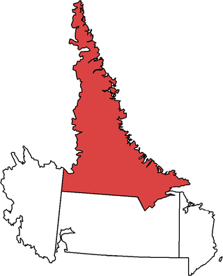
Nunatsiavut is an autonomous area claimed by the Inuit in Newfoundland and Labrador, Canada. The settlement area includes territory in Labrador extending to the Quebec border. In 2002, the Labrador Inuit Association submitted a proposal for limited autonomy to the government of Newfoundland and Labrador. The constitution was ratified on December 1, 2005, at which time the Labrador Inuit Association ceased to exist, and the new Government of Nunatsiavut was established, initially being responsible for health, education and cultural affairs. It is also responsible for setting and conducting elections, the first of which was executed in October 2006. An election for the ordinary members of the Nunatsiavut Assembly was held on May 4, 2010. Its incumbent president is Johannes Lampe who assumed office in 2016.

<span class="mw-page-title-main">Nain, Newfoundland and Labrador</span> Inuit community in Newfoundland and Labrador, Canada

Nain is the northernmost permanent settlement in the Canadian province of Newfoundland and Labrador, within the Nunatsiavut region, located about 370 km (230 mi) by air from Happy Valley-Goose Bay. The town was established as a Moravian mission in 1771 by Jens Haven and other missionaries. As of 2021, the population is 1,204 mostly Inuit and mixed Inuit-European. Nain is the administrative capital of the autonomous region of Nunatsiavut.

<span class="mw-page-title-main">Hopedale, Newfoundland and Labrador</span> Inuit community in Newfoundland and Labrador, Canada

Hopedale is a town located in the north of Labrador, the mainland portion of the Canadian province of Newfoundland and Labrador. Hopedale is the legislative capital of the Inuit Land Claims Area Nunatsiavut, and where the Nunatsiavut Assembly meets. As of the 2021 census, it has a population of 596.

<span class="mw-page-title-main">Torngat Mountains (electoral district)</span> Provincial electoral district in Newfoundland and Labrador, Canada

Torngat Mountains is a provincial electoral district for the House of Assembly of Newfoundland and Labrador, Canada. As of 2011 there are 2,130 eligible voters living within the district. The district takes its name from the Torngat Mountains.

<span class="mw-page-title-main">Happy Valley-Goose Bay</span> Town in Newfoundland and Labrador, Canada

Happy Valley-Goose Bay is a town in the province of Newfoundland and Labrador, Canada.

The Mushuau Innu First Nation is a First Nations band government located in the province of Newfoundland and Labrador, Canada. The band has one reserve which has been located near the community of Natuashish since 2002 when it moved from Davis Inlet. The reserve has an area of roughly 44 square kilometres.

<span class="mw-page-title-main">Cartwright, Newfoundland and Labrador</span> Town in Newfoundland and Labrador, Canada

Cartwright is a community located on the eastern side of the entrance to Sandwich Bay, along the southern coast of Labrador in the province of Newfoundland and Labrador, Canada. It was incorporated in 1956.

<span class="mw-page-title-main">Rigolet</span> Inuit community in Newfoundland and Labrador, Canada

Rigolet is a remote, coastal Labrador community established in 1735 by French-Canadian trader Louis Fornel. The town is the southernmost officially recognized Inuit community in the world. Located on Hamilton Inlet, which is at the entrance to fresh water Lake Melville; Rigolet is on salt water and is accessible to navigation during the winter. Although there is no road access, the community is accessible by snowmobile trail, the Rigolet Airport, or seasonally via a coastal ferry from Happy Valley-Goose Bay.

St. Lewis is a community on the coast of Labrador in the province of Newfoundland and Labrador, Canada. Formerly known as Fox Harbour, St. Lewis is the most easterly permanent community on the North American mainland. The community of St. Lewis enjoys a long and vibrant history as one of the earliest recorded places in all of Labrador by Europeans. Settled in the early 18th century, the area’s sheltered location, proximity to good fishing grounds and seal migration routes made the settlement a desired location for both the European-based migratory fishery, and the native Inuit families who inhabited the south Labrador coast.

<span class="mw-page-title-main">Abraham Ulrikab</span> Inuk from Hebron, Labrador

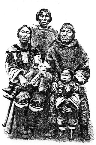
Abraham Ulrikab was an Inuk from Hebron, Labrador, in the present-day province of Newfoundland and Labrador, Canada, who – along with his family and four other Inuit – agreed to become the latest attraction in the ethnographical shows organized by Carl Hagenbeck, owner of the Tierpark Hagenbeck, a zoo in Hamburg, Germany.

<span class="mw-page-title-main">Torngat Mountains National Park</span> National park in Newfoundland and Labrador, Canada

Torngat Mountains National Park is a Canadian national park located on the Labrador Peninsula in the province of Newfoundland and Labrador. The park encompasses 9,700 km2 of mountainous terrain between Northern Quebec and the Labrador Sea. It is the largest national park in Atlantic Canada and the southernmost national park in the Arctic Cordillera. It partially contains the Torngat Mountains, the highest mountains in mainland Canada east of the Rocky Mountains.

<span class="mw-page-title-main">Postville, Newfoundland and Labrador</span> Town in Newfoundland and Labrador, Canada

Postville is an Inuit town in the north of Labrador, Canada. It had a population of 188 as of 2021. It is located about 40 km (25 mi) inside Kaipokok Bay, 180 km (110 mi) NNE of Happy Valley-Goose Bay. Postville Airport is nearby.

Wally Andersen is a former Liberal Member of the House of Assembly in the Canadian province of Newfoundland and Labrador. He was first elected in 1996 in the riding Torngat Mountains and was re-elected twice.

<span class="mw-page-title-main">Inuit Nunangat</span> Inuit regions of Canada

Inuit Nunangat refers to the land, water, and ice of the homeland of Inuit in Canada. This Arctic homeland consists of four northern Canadian regions called the Inuvialuit Settlement Region, the territory Nunavut (ᓄᓇᕗᑦ), Nunavik (ᓄᓇᕕᒃ) in northern Quebec, and Nunatsiavut of Newfoundland and Labrador.

Randy Edmunds is a Canadian politician in Newfoundland and Labrador. He was elected to the Newfoundland and Labrador House of Assembly in the 2011 provincial election. A member of the Liberal Party of Newfoundland and Labrador, he represented the electoral district of Torngat Mountains until 2019.

<span class="mw-page-title-main">NunatuKavut</span> Proposed Autonomous area in Newfoundland and Labrador, Canada

NunatuKavut is an unrecognized Inuit territory in Labrador. The NunatuKavut people claim to be the direct descendants of the Inuit that lived south of the Churchill or Grand River prior to European contact, with recent European admixture primarily from English settlers. Despite claims of Inuit heritage, according to recent censuses completed by Statistics Canada, the vast majority of individuals living in communities that NunatuKavut claims are within its region continue to identify as Métis as opposed to 'Inuit'.

William Andersen III is a former politician in Labrador, Canada. He represented Torngat Mountains in the Newfoundland House of Assembly from 1993 to 1996.

<span class="mw-page-title-main">Nunatsiavut Assembly</span> Legislative branch of Nunatsiavut, Canada

The Nunatsiavut Assembly is the legislative branch of the government of Nunatsiavut, Canada.

Lela Margaret Ann Evans is a Canadian politician, who was elected to the Newfoundland and Labrador House of Assembly in the 2019 provincial election. She represents the electoral district of Torngat Mountains as a New Democrat, having previously been elected as a Progressive Conservative. She was re-elected in the 2021 provincial election.

References

  1. "Word List". Inuktut Lexicon Atlas. Retrieved October 16, 2020.
  2. "Makkovik". Geographical Names Data Base . Natural Resources Canada.
  3. "Makkovik". Geographical Names Data Base . Natural Resources Canada.
  4. 1 2 3 "Census Profile, 2021 Census of Population Data table Makkovik, Town (T)More information: Newfoundland and Labrador [Census subdivision]". Statistics Canada. February 9, 2022. Retrieved March 10, 2022.
  5. Moore, Angel (April 5, 2020). "Indigenous leaders asking that access to Labrador be sealed off". APTN News. Retrieved October 16, 2020.
  6. Churchill Duke, Laura (September 20, 2019). "Hopedale woman circulating petition calling for the province to subsidize flights to northern Labrador". Saltwire. Retrieved July 23, 2021.
  7. "Inuit : Labrador Virtual Museum".
  8. Fitzhugh, Lynne D. (1999). The Labradorians: Voices from the Land of Cain. Breakwater Books. ISBN   9781550811483.
  9. "Inuit mark 50th anniversary of Labrador resettlement". CBC News. August 12, 2009. Retrieved October 16, 2020.
  10. "Ceremony to mark forced relocation of Inuit village". CBC News. August 15, 2012. Retrieved October 16, 2020.
  11. "Relocated Labrador Inuit to get apology monument". CBC News. July 24, 2009. Retrieved October 16, 2020.
  12. "Town of Makkovik Municipal Plan 2007-2017" (PDF). Government of Newfoundland and Labrador - Environment, Climate Change and Municipalities. D.W. Knight Associates. Retrieved October 16, 2020.
  13. "1 year after inquiry announced, Burton Winters's family hopeful for action soon". CBC News. December 4, 2019. Retrieved October 16, 2020.
  14. "Burton Winters's death prompts long-awaited inquiry into search and rescue services". CBC news. December 4, 2018. Retrieved October 16, 2020.
  15. "Census Profile, 2016 Census". Statistics Canada. February 8, 2017. Retrieved October 16, 2020.
  16. Buss, Lydus (April 1, 1957). "US Air Defense in the Northeast 1940-1957". c-and-e-museum.org. Retrieved October 16, 2020.
  17. "About Pinetree Line". Canadian Civil Defence Museum and Archives. Retrieved October 16, 2020.
  18. 1 2 3 "Canadian Climate Normals 1981-2010 Station Data". Environment and Climate Change Canada. March 2, 2022. Climate ID: 8502NHR. Retrieved March 13, 2022.
  19. "Makkovik Inuit Community Government : Makkovik". www.makkovik.ca. Retrieved November 27, 2023.
  20. "Summary of Polling Divisions TORNGAT MOUNTAINS" (PDF). Elections Newfoundland and Labrador. August 3, 2011. Retrieved September 5, 2011.
  21. "Unofficial results of the Nunatsiavut General Election. | Nunatsiavut Government". Archived from the original on August 10, 2016. Retrieved June 10, 2016.
  22. "Nunatsiavut first minister resigns amid allegations she acted inappropriately | CBC News".
  23. "Andersen acclaimed Ordinary Member for Makkovik". January 22, 2020.
  24. "Media release. Official results of May 3 general election for Ordinary Members to the Nunatsiavut Assembly" (PDF). nunatsiavut.com. May 10, 2022. Retrieved November 27, 2023.