Pinetree Line

Last updated

Pinetree Line
Dew line 1960.jpg
Active1951–1991
CountryCanada
Branch Royal Canadian Air Force
United States Air Force
Type Early-warning radar
RoleContinental Air Defense
Part of North American Aerospace Defense Command

The Pinetree Line was a series of radar stations located across southern Canada at about the 50th parallel north, along with a number of other stations located on the Atlantic and Pacific coasts. Run by North American Aerospace Defense Command (NORAD) (after its creation), over half were staffed by United States Air Force personnel with the balance operated by the Royal Canadian Air Force. The line was the first coordinated system for early detection of a Soviet bomber attack on North America, but before the early 1950s radar technology quickly became outdated and the line was in full operation only for a short time.

Contents

History

Static display of an AN/FPS 508 radar antenna, one of the types used on the Pinetree Line. The antenna rotated at 5 revolutions per minute. The system could detect aircraft up to 200 mi (320 km) away and at altitudes of 100,000 ft (30,000 m). This antenna is on display at Air Force Heritage Museum and Air Park, Winnipeg Pinetree Line Radar Parabolic Antenna.jpg
Static display of an AN/FPS 508 radar antenna, one of the types used on the Pinetree Line. The antenna rotated at 5 revolutions per minute. The system could detect aircraft up to 200 mi (320 km) away and at altitudes of 100,000 ft (30,000 m). This antenna is on display at Air Force Heritage Museum and Air Park, Winnipeg

Plans for what would become the Pinetree Line were underway as early as 1946 within the Permanent Joint Board on Defense (PJBD), a Canadian-U.S. organization. However, the costs of running such a system in the post-war era was too high, and instead Canada concentrated on the areas around Ontario and Quebec, while the United States set up stations in the Midwest and along the eastern seaboard. With the successful test of an atomic bomb in the USSR, plans changed considerably. In 1949 Congress agreed to a $161 million construction program in co-operation with the RCAF, for a continuous line of stations across southern Canada. The USAF's Continental Air Command and the RCAF met in October 1950 to start planning, and in January 1951 the PJBD presented Recommendation 51/1 for the Extension of the Continental Radar Defence System. The USAF later requested an additional set of six (potentially) mobile stations to provide low-level coverage. Later, it was learned the original radar systems performed better than expected, hence a number of the mobile sites were never deployed.

The system was eventually deployed as a series of 33 main stations and 6 smaller "gap fillers". The majority of these ran in a line at about the 53rd parallel in the west (to offer coverage of major Canadian cities) and about the 50th parallel in the east. A second line ran up the eastern seaboard from the southern tip of Nova Scotia to the southern tip of Baffin Island. Of these, 22 of the main stations and all of the gap fillers were paid for by the USAF, leaving 11 to the RCAF. However 16 of the main stations were staffed by RCAF personnel. On 1 January 1955, the system was officially handed over to RCAF command, and over time an additional 10 stations were added. The stations on the east coast used the Pole Vault system for communication.

Saint Anthony Air Station, Newfoundland in July 1961. The main radar is centered, the Pole Vault antennas are on the right. Saint Anthony Air Station aerial view July 1961.jpg
Saint Anthony Air Station, Newfoundland in July 1961. The main radar is centered, the Pole Vault antennas are on the right.

The Pinetree Line had several technical problems that limited its usefulness almost immediately. For one, the system used a simple pulse radar technique, which made it unable to detect targets close to the ground due to radar clutter as well as being trivially easy to jam using the recently-introduced carcinotron tube. Another was that its location near population centres meant it offered only a last minute warning, and as the USSR moved to jet-powered bombers the warning time was reduced. Studies were already underway in 1951 to build a series of Doppler bistatic radar stations somewhat farther north, which would develop into the Mid-Canada Line. By 1957, just over a year after the Mid-Canada Line was operational, a more advanced long-range search radar, mainly in the Canadian north and Alaska were deployed comprising the Distant Early Warning Line.

The Pinetree stations were kept operational during this period, and most underwent modifications as a part of the deployment of the Semi-Automatic Ground Environment (SAGE). SAGE dramatically reduced the workload at the stations, cutting staff requirements by well over half. By the later 1950s some were being mothballed as newer systems came on line to the north. Nevertheless, many of the Pinetree stations were kept operational into the 1980s, particularly on the Atlantic and Pacific coasts.

Radar stations

Initial sort is based on longitude from east to west.

Site numberNameProvinceLocationUnitServiceActivatedDeactivated
N-22 Red Cliff Air Station
St. Johns Air Station
NL 642d Aircraft Control and Warning SquadronUSAF19531961
N-22B Elliston Ridge Air Station NL 642d Aircraft Control and Warning SquadronUSAF19571961
N-25 CFB Gander NL 226 Aircraft Control and Warning (later Radar) SquadronRCAF19531990
N-26B La Scie Air Station NL 921st Aircraft Control and Warning SquadronUSAF19571961
N-26 Saint Anthony Air Station NL 921st Aircraft Control and Warning SquadronUSAF19531968
N-27C Fox Harbour Air Station NL 922d Aircraft Control and Warning SquadronUSAF19571961
N-27B Spotted Island Air Station NL 922d Aircraft Control and Warning SquadronUSAF19571961
N-27 Cartwright Air Station NL 922d Aircraft Control and Warning SquadronUSAF19531968
N-27A Cut Throat Island Air Station NL 922d Aircraft Control and Warning SquadronUSAF19571961
N-23 Stephenville Air Station NL 105th Aircraft Control and Warning Squadron
640th Aircraft Control and Warning Squadron
USAF19521971
N-28A Cape Makkovik Air Station NL 923d Aircraft Control and Warning SquadronUSAF19571961
C-34 CFS Sydney NS 221 Aircraft Control and Warning (later Radar) SquadronRCAF19541991
N-28 Hopedale Air Station NL 923d Aircraft Control and Warning SquadronUSAF19531968
C-24 Goose Air Force Base NL Goose Air Defense Sector
21st Air Division
26th Air Division
37th Air Division
59th Fighter-Interceptor Squadron
64th Air Division
95th Strategic Wing
4082d Strategic Wing
4732d Air Defense Group
6603d Air Base Group
USAF19531971
N-24 Melville Air Station NL 107th Aircraft Control and Warning Squadron
641st Aircraft Control and Warning Squadron
641 Aircraft Control and Radar Squadron
USAF
RCAF
19531988
N-29 CFS Saglek NL 924th Aircraft Control and Warning SquadronUSAF19531970
C-11 RCAF Beaverbank NS 22 Aircraft Control and Warning (later Radar) SquadronRCAF19541964
N-30 CFS Resolution Island NT [lower-alpha 1] 920th Aircraft Control and Warning Squadron USAF19511961
C-5 CFS St. Margarets NB 21 Aircraft Control and Warning (later Radar) SquadronRCAF19531988
C-102 CFS Barrington NS 672d Aircraft Control and Warning Squadron
23 Aircraft Control and Warning (later Radar) Squadron
USAF
RCAF
19571990
C-33 CFS Moisie QC 211 Aircraft Control and Warning (later Radar) SquadronRCAF19531988
N-31 Frobisher Bay Air Base NT [lower-alpha 1] 926th Aircraft Control and Warning Squadron USAF19531961
C-6 RCAF St. Sylvestre QC 13 Aircraft Control and Warning (later Radar) SquadronRCAF19551964
C-1 CFS Mont Apica QC 12 Aircraft Control and Warning (later Radar) SquadronRCAF19521990
C-2 CFS Lac St. Denis QC 11 Aircraft Control and Warning (later Radar) SquadronRCAF19521986
C-42 CFS Chibougamau QC 10 Aircraft Control and Warning (later Radar) SquadronRCAF19621988
C-7 RCAF Parent QC 14 Aircraft Control and Warning (later Radar) SquadronRCAF19541964
C-8 CFS Senneterre QC 34 Aircraft Control and Warning (later Radar) SquadronRCAF19531988
C-3 CFS Foymount ON 32 Aircraft Control and Warning (later Radar) SquadronRCAF19521974
C-4 CFS Edgar ON 31 Aircraft Control and Warning (later Radar) SquadronRCAF19531964
C-10 CFS Ramore ON 912th Aircraft Control and Warning Squadron
35 Aircraft Control and Warning (later Radar) Squadron
USAF
RCAF
19531974
C-44 CFS Moosonee ON 15 Aircraft Control and Warning (later Radar) SquadronRCAF19611975
C-9 CFS Falconbridge ON 33 Aircraft Control and Warning (later Radar) SquadronRCAF19521986
C-119 CFS Lowther ON 639th Aircraft Control and Warning Squadron
36 Aircraft Control and Warning (later Radar) Squadron
USAF
RCAF
19571987
C-14 RCAF Station Pagwa ON 913th Aircraft Control and Warning Squadron
37 Aircraft Control and Warning (later Radar) Squadron
USAF
RCAF
19521966
C-15 CFS Armstrong ON 914th Aircraft Control and Warning Squadron
38 Aircraft Control and Warning (later Radar) Squadron
USAF
RCAF
19521974
C-16 CFS Sioux Lookout ON 915th Aircraft Control and Warning Squadron
39 Aircraft Control and Warning (later Radar) Squadron
USAF
RCAF
19531987
C-17 CFS Beausejour MB 916th Aircraft Control and Warning Squadron
48 Aircraft Control and Warning (later Radar) Squadron
USAF
RCAF
19531988
C-49 CFS Gypsumville MB 47 Aircraft Control and Warning (later Radar) SquadronRCAF19621987
C-51 CFS Yorkton SK 46 Aircraft Control and Warning (later Radar) SquadronRCAF19631986
C-52 CFS Dana SK 45 Aircraft Control and Warning (later Radar) SquadronRCAF19641987
C-53 CFS Alsask SK 44 Aircraft Control and Warning (later Radar) SquadronRCAF19531986
C-36 CFB Cold Lake AB 42 Aircraft Control and Warning (later Radar) SquadronRCAF19541991
C-54 CFS Penhold AB 43 Aircraft Control and Warning (later Radar) SquadronRCAF19641986
C-21RCAF Saskatoon Mountain
CFS Beaverlodge
AB 919th Aircraft Control and Warning Squadron
57 Aircraft Control and Warning (later Radar) Squadron
USAF
RCAF
19531988
C-153 CFS Kamloops BC 825th Aircraft Control and Warning Squadron
56 Aircraft Control and Warning (later Radar) Squadron
USAF
RCAF
19571988
C-20 CFS Baldy Hughes BC 918th Aircraft Control and Warning Squadron
54 Aircraft Control and Warning (later Radar) Squadron
USAF
RCAF
19531988
C-19 RCAF Station Puntzi Mountain BC 917th Aircraft Control and Warning Squadron
55 Aircraft Control and Warning (later Radar) Squadron
USAF
RCAF
19521966
C-35 CFB Comox BC 51 Aircraft Control and Warning (later Radar) SquadronRCAF19541958
C-36 RCAF Tofino BC 52 Aircraft Control and Warning SquadronRCAF19551957
C-18 CFS Holberg BC 501 Aircraft Control and Warning (later Radar) Squadron
53 Radar Squadron
RCAF19541991
  1. 1 2 These stations were originally in the NT but are currently located in Nunavut

See also

Related Research Articles

<span class="mw-page-title-main">Mid-Canada Line</span> Canadian radar defence line

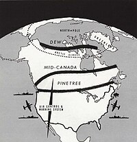
The Mid-Canada Line (MCL), also known as the McGill Fence, was a line of radar stations running east–west across the middle of Canada, used to provide early warning of a Soviet bomber attack on North America. It was built to supplement the Pinetree Line, which was located farther south. The majority of Mid-Canada Line stations were used only briefly from the late 1950s to the mid-1960s, as the attack threat changed from bombers to ICBMs. As the MCL was closed down, the early warning role passed almost entirely to the newer and more capable DEW Line farther north.

<span class="mw-page-title-main">CFS Barrington</span>

Canadian Forces Station Barrington, also referred to as CFS Barrington, was a Canadian Forces Station located in the unincorporated community of Baccaro, Nova Scotia at Baccaro Point near the southwesternmost point of the province.

Canadian Forces Station Lowther is a closed General Surveillance Radar station. It is located 12.7 miles (20.4 km) east-southeast of Mattice-Val Côté, Ontario. It was closed in 1987.

Canadian Forces Station Sydney, also known as CFS Sydney, is a former Canadian Forces Station located in the community of Lingan Road, Nova Scotia.

North Charleston Air Force Station is a closed United States Air Force General Surveillance Radar station. It is located in the City of North Charleston, South Carolina. It was closed in 1980.

<span class="mw-page-title-main">Winston-Salem Air Force Station</span> Closed United States Air Force General Surveillance Radar station in North Carolina

Winston-Salem Air Force Station is a closed United States Air Force General Surveillance Radar station that was active from 1956 to 1970. It is located 1 mile (1.6 km) southeast of Winston-Salem, North Carolina.

<span class="mw-page-title-main">CFS Ramore</span> US radar station in Ontario, Canada 1953–1974

Canadian Forces Station Ramore is a closed General Surveillance Radar station. It is located 4 miles (6.4 km) east of Ramore, Ontario. It was closed in 1974. It was operated as part of the Pinetree Line network controlled by NORAD. It has since been sold and is now private property.

Canadian Forces Station Sioux Lookout is a closed General Surveillance Radar station. It is located 3.7 miles (6.0 km) west of Sioux Lookout, Ontario. It was closed in 1987.

<span class="mw-page-title-main">CFS Beaverlodge</span> Radar station in Alberta, Canada 1953–1988

Canadian Forces Station Beaverlodge is a closed General Surveillance Radar station. It is located 4.9 miles (7.9 km) east-northeast of Beaverlodge, Alberta. It was closed in 1988.

<span class="mw-page-title-main">CFS Beausejour</span> Radar station in Manitoba, Canada 1953–1986

Canadian Forces Station Beausejour is a closed General Surveillance Radar station. It is located 45.1 miles (72.6 km) east-northeast of Winnipeg, Manitoba. It was closed in 1986.

<span class="mw-page-title-main">CFS Baldy Hughes</span> Radar station in British Columbia, Canada 1953–1988

Canadian Forces Station Baldy Hughes is a closed General Surveillance Radar station. It is located 22.3 miles (35.9 km) south-southwest of Prince George, British Columbia. It was closed in 1988.

<span class="mw-page-title-main">CFS Kamloops</span> Radar station in British Columbia, Canada 1957–1988

Canadian Forces Station Kamloops is a closed General Surveillance Radar station. It is located 12.8 miles (20.6 km) northeast of Kamloops, British Columbia on the peak of Mount Lolo. It was closed in 1988 due to advances in military technology which made it obsolete.

Elliston Ridge Air Station was a General Surveillance Gap Filler Radar station in the Canadian province of Newfoundland and Labrador, It was located 74 miles (119 km) north-northwest of St. John's. It was closed in 1961.

<span class="mw-page-title-main">La Scie Air Station</span> US Air Force radar station

La Scie Air Station was a General Surveillance Gap Filler Radar station in the Canadian province of Newfoundland and Labrador, It was located 210 miles (340 km) east-northeast of St.John's, Near La Scie. It was closed in 1961.

<span class="mw-page-title-main">Cape Makkovik Air Station</span> General Surveillance Gap Filler Radar station

Cape Makkovik Air Station was a General Surveillance Gap Filler Radar station in the Canadian province of Newfoundland and Labrador, It was located 140 miles (230 km) north-northeast of CFB Goose Bay. It was closed in 1961.

<span class="mw-page-title-main">Cut Throat Island Air Station</span> Former US Air Force radar station in Canada

Cut Throat Island Air Station was a General Surveillance Gap Filler Radar station in the Canadian province of Newfoundland and Labrador, It was located 160 miles (260 km) east-northeast of CFB Goose Bay. It was closed in 1961.

<span class="mw-page-title-main">Spotted Island Air Station</span> General Surveillance Gap Filler Radar station

Spotted Island Air Station was a General Surveillance Gap Filler Radar station in the Canadian province of Newfoundland and Labrador, It was located 195 miles (314 km) east of CFB Goose Bay. It was closed in 1961.

<span class="mw-page-title-main">Fox Harbour Air Station</span> Canadian radar station

Fox Harbour Air Station was a General Surveillance Gap Filler Radar station in St. Lewis in the Canadian province of Newfoundland and Labrador, It was located 210 miles (340 km) southeast of CFB Goose Bay. It was closed in 1961.

<span class="mw-page-title-main">Continental Air Defense Command</span> Former US military formation

Continental Air Defense Command (CONAD) was a Unified Combatant Command of the United States Department of Defense, tasked with air defense for the Continental United States. It comprised Army, Air Force, and Navy components. It included Army Project Nike missiles anti-aircraft defenses and USAF interceptors. The primary purpose of continental air defense during the CONAD period was to provide sufficient attack warning of a Soviet bomber air raid to ensure Strategic Air Command could launch a counterattack without being destroyed. CONAD controlled nuclear air defense weapons such as the 10 kiloton W-40 nuclear warhead on the CIM-10B BOMARC. The command was disestablished in 1975, and Aerospace Defense Command became the major U.S. component of North American Air Defense Command (NORAD).

Royal Canadian Air Force Station St. Sylvestre was a Radar station of the Canadian Pinetree Line, located at Saint-Sylvestre, Quebec, in the Lotbinière Region, sixty-nine kilometres south Quebec City. Construction starting in 1952, the Station opened on 15 September 1953, first as RCAF Station Ste-Marie, being renamed RCAF Station St. Sylvestre, on 1 August 1955.

References

PD-icon.svg This article incorporates public domain material from the Air Force Historical Research Agency