Maple Heights, Ohio

Last updated

Maple Heights, Ohio
Southern end of Vine Street, Maple Heights.jpg
Residential neighborhood along Vine Street
Cuyahoga County Ohio incorporated and unincorporated areas Maple Heights highlighted.svg
Location in Cuyahoga County and the state of Ohio.
Coordinates: 41°24′44″N81°33′35″W / 41.41222°N 81.55972°W / 41.41222; -81.55972
Country United States
State Ohio
County Cuyahoga
Incorporated1915
Government
  Type Mayor-Council
   Mayor Annette M. Blackwell
Area
[1]
  Total5.17 sq mi (13.39 km2)
  Land5.17 sq mi (13.39 km2)
  Water0.00 sq mi (0.00 km2)
Elevation
[2]
896 ft (273 m)
Population
 (2020)
  Total23,701
  Density4,585.22/sq mi (1,770.30/km2)
Time zone UTC-5 (Eastern (EST))
  Summer (DST) UTC-4 (EDT)
ZIP code
44137
Area code 216
FIPS code 39-47306 [3]
GNIS feature ID1048945 [2]
Interstates I-480.svg
Rapid Transit GCRTA wordmark logo.svg
Website https://www.citymapleheights.com/

Maple Heights is a city in Cuyahoga County, Ohio, United States. It is a suburb of Cleveland. The population was 23,701 at the 2020 census.

Contents

History

In 1935, the city created Maple Heights Transit to provide connections to Downtown Cleveland, crosstown service, and service for schools. [4]

Built as one of the first large shopping centers, Southgate USA was dedicated in 1955, boasting over 80 retail stores, including JCPenney, Sears, and May Company. [5] In 2002, the GCRTA dedicated its Southgate Transit Center, serving as a connection between multiple bus lines between Downtown Cleveland, Bedford, Shaker Heights, East Cleveland, and the Summit County Line. [6] [7]

With deficit fund balances of over $2.8 million and defaults on 3 loan payments, Ohio Auditor of State Dave Yost declared the City to be in fiscal emergency in February 2015. [8] Since February 2015, the City improved its finances and budgeting since with fund balances increasing and the general fund balance becoming positive in 2019—the first time since the fiscal emergency declaration. [9] The City was released from fiscal emergency on November 18, 2020 by the Auditor of State; in the press release, Auditor of State Keith Faber said, "I applaud the leaders of the City for making the sacrifices and hard decisions that should provide residents a fiscally responsible community." [10]

In 2020, Governor Mike DeWine announced that GOJO Industries, makers of Purell, would establish a manufacturing facility in the City in the 325,000 square foot former Blue Coral building on Lee Road South. [11] The Maple Heights facility was projected to bring 100 new jobs to the City. [11]

Geography

According to the United States Census Bureau, the city has a total area of 5.17 square miles (13.39 km2), all land. [12]

Demographics

Historical population
CensusPop.Note
1920 1,732
1930 5,950243.5%
1940 6,72813.1%
1950 15,586131.7%
1960 31,667103.2%
1970 34,0937.7%
1980 29,465−13.6%
1990 27,089−8.1%
2000 26,156−3.4%
2010 23,138−11.5%
2020 23,7012.4%
Sources: [3] [13] [14]

2020 census

Maple Heights city, Ohio – Racial and ethnic composition
Note: the U.S. census treats Hispanic/Latino as an ethnic category. This table excludes Latinos from the racial categories and assigns them to a separate category. Hispanics/Latinos may be of any race.
Race / Ethnicity (NH = Non-Hispanic)Pop 2010 [15] Pop 2020 [16] % 2010% 2020
White alone (NH)6,3734,32227.54%18.24%
Black or African American alone (NH)15,68217,67967.78%74.59%
Native American or Alaska Native alone (NH)35480.15%0.20%
Asian alone (NH)2331341.01%0.57%
Pacific Islander alone (NH)050.00%0.02%
Some Other Race alone (NH)371340.16%0.57%
Mixed Race or Multi-Racial (NH)4217231.82%3.05%
Hispanic or Latino (any race)3576531.54%2.76%
Total23,13823,701100.00%100.00%

2010 census

As of the census [17] of 2010, there were 23,138 people, 9,515 households, and 6,035 families living in the city. The population density was 4,475.4 inhabitants per square mile (1,728.0/km2). There were 10,894 housing units at an average density of 2,107.2 per square mile (813.6/km2). The racial makeup of the city was 68.2% African American, 28.0% White, 0.2% Native American, 1.0% Asian, 0.5% from other races, and 2.1% from two or more races. Hispanic or Latino of any race were 1.5% of the population.

There were 9,515 households, of which 32.5% had children under the age of 18 living with them, 33.0% were married couples living together, 25.0% had a female householder with no husband present, 5.4% had a male householder with no wife present, and 36.6% were non-families. 32.1% of all households were made up of individuals, and 10.4% had someone living alone who was 65 years of age or older. The average household size was 2.41 and the average family size was 3.05.

The median age in the city was 39.2 years. 25.1% of residents were under the age of 18; 8.3% were between the ages of 18 and 24; 24.5% were from 25 to 44; 28.8% were from 45 to 64; and 13.2% were 65 years of age or older. The gender makeup of the city was 46.3% male and 53.7% female.

2000 census

As of the census [3] of 2000, there were 26,156 people, 10,489 households, and 6,964 families living in the city. The population density was 5,039.1 inhabitants per square mile (1,945.6/km2). There were 10,935 housing units at an average density of 2,106.7 per square mile (813.4/km2). The racial makeup of the city was 51.65% White, 44.34% African American, 0.13% Native American, 1.73% Asian, 0.02% Pacific Islander, 0.47% from other races, and 1.66% from two or more races. Hispanic or Latino of any race were 1.21% of the population.

There were 10,489 households, of which 30.9% had children under the age of 18 living with them, 45.2% were married couples living together, 17.0% had a female householder with no husband present, and 33.6% were non-families. 29.9% of all households were made up of individuals, and 12.5% had someone living alone who was 65 years of age or older. The average household size was 2.47 and the average family size was 3.08.

In the city, the population was spread out, with 25.7% under the age of 18, 6.7% from 18 to 24, 30.9% from 25 to 44, 20.1% from 45 to 64, and 16.5% who were 65 years of age or older. The median age was 37 years. For every 100 females, there were 87.8 males. For every 100 females age 18and over, there were 82.7 males.

The median income for a household in the city was $40,414, and the median income for a family was $48,580. Males had a median income of $35,268versus $28,023 for females. The per capita income for the city was $18,676. About 4.7% of families and 5.9% of the population were below the poverty line, including 7.7% of those under age 18 and 6.0% of those age 65 or over.

Government

The City of Maple Heights has a strong-mayor government form and is governed by an elected mayor, elected council president, and elected council. [18]

Mayors

The City has had 16 people serve as mayor, including current mayor, Annette M. Blackwell, with 2 mayors having served in non-consecutive terms. Between the city's founding and the current administration, there have been a total of 18 mayoral administrations. Mayor Blackwell was elected in 2015 as the first female and first African American mayor in the city's history. [19] [20]

City Council

The council has seven members, with each member representing a portion of the city, known as a district. The City of Maple Heights has a municipal election on November 2, 2021 with Council President and Councilmembers for Districts 1, 3, 5, and 7 up for election. Before the General Election in 2017, Council President and Councilmembers were elected every two years. Following the approval of Issue 68, Council President and Councilmembers are elected for four year terms with even numbered District Councilmembers elected in 2019 and every four years thereafter and odd numbered District Councilmembers elected in 2017 and every four years thereafter. [18] [21]

Member of the City Council include: [22]

  • Ron Jackson, council president
  • Leonette F. Cicirella, clerk of council
  • Stafford L. Shenett Sr., District 1 councilman
  • Toni Jones, District 2 councilwoman
  • Timothy Tatum, District 3 councilman
  • Dana Anderson, District 4 councilwoman
  • Tanglyn Madden, District 5 councilwoman
  • Richard Trojanski, District 6 councilman
  • Edwina Agee, District 7 councilwoman

Education

Public Schools

The city's public school system is the Maple Heights City School District. The District is managed by a superintendent and a directly elected board. The school district has 5 schools:

Private School

Notable people

Related Research Articles

<span class="mw-page-title-main">Cuyahoga County, Ohio</span> County in Ohio, United States

Cuyahoga County is a large urban county located in the northeastern part of the U.S. state of Ohio. The county seat and largest city is Cleveland. As of the 2020 census, its population was 1,264,817, making it the second-most populous county in the state.

<span class="mw-page-title-main">Columbiana, Alabama</span> City in and county seat of Shelby County, Alabama

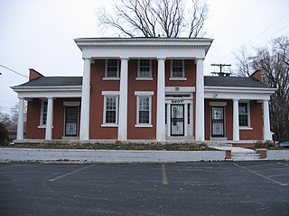
Columbiana is a city and the county seat of Shelby County, Alabama, United States. At the 2020 census, the population was 4,462.

<span class="mw-page-title-main">Capitol Heights, Maryland</span> Town in Maryland

Capitol Heights is a town in Prince George's County, Maryland, United States, located on the border of both the Northeast & Southeast quadrants of Washington. Per the 2020 census, the population was 4,050. The town of Capitol Heights is officially bounded between Southern Avenue NE/SE to the north, Yost Place, and Eastern Avenue NE to the east, the Watts Branch Stream, Brooke Road, and Capitol Heights Boulevard to the south, and Marlboro Pike to the west. The zip code of Capitol Heights is 20743.

<span class="mw-page-title-main">Fairmount Heights, Maryland</span> Historic district in Maryland, United States

Fairmount Heights is a town in Prince George's County, Maryland, United States. Per the 2020 census, the population was 1,528. The town was formally incorporated in 1935, making the town the second oldest African-American-majority municipality in Prince George's County. The town is composed of six subdivisions: Fairmount Heights (1900), Waterford (1907), Mount Weissner (1909), North Fairmount Heights (1910), West Fairmount Heights (1911) and Sylvan Vista (1923).

<span class="mw-page-title-main">Salem, Ohio</span> City in Ohio, United States

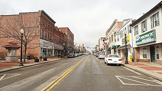
Salem is a city in northern Columbiana County, Ohio, United States. At the 2020 census, the city's population was 11,915. Extending into southern Mahoning County, it is the principal city of the Salem micropolitan area, which includes all of Columbiana County. It lies about 18 miles (29 km) southwest of Youngstown, 28 miles (45 km) east of Canton, and 60 miles (97 km) southeast of Cleveland.

<span class="mw-page-title-main">Bedford, Ohio</span> City in Ohio, United States

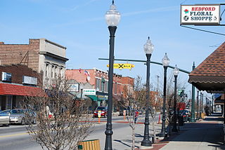
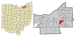
Bedford is a city in Cuyahoga County, Ohio, United States. The population was 13,149 at the 2020 census. It is an eastern suburb of Cleveland.

<span class="mw-page-title-main">Broadview Heights, Ohio</span> City in Ohio, United States

Broadview Heights is a city in southern Cuyahoga County, Ohio, United States. The city's population was 19,936 at the 2020 census. A suburb of Cleveland, it is part of the Cleveland metropolitan area.

<span class="mw-page-title-main">Cleveland Heights, Ohio</span> City in Ohio, United States

Cleveland Heights is a city in Cuyahoga County, Ohio, United States. The population was 45,312 at the 2020 census. One of Cleveland's historic streetcar suburbs, it was founded as a village in 1903 and a city in 1921.

<span class="mw-page-title-main">East Cleveland, Ohio</span> City in Ohio, United States

East Cleveland is a city in Cuyahoga County, Ohio, United States. The population was 13,792 at the 2020 census. It is a suburb lying east and south of Cleveland and west of Cleveland Heights.

<span class="mw-page-title-main">Euclid, Ohio</span> City in Ohio, United States

Euclid is a city in Cuyahoga County, Ohio, United States. Located on the southern shore of Lake Erie, it is an inner ring suburb of Cleveland. The population was 49,692 at the 2020 census, making it the fourth largest city in Cuyahoga County.

<span class="mw-page-title-main">Garfield Heights, Ohio</span> City in Ohio, United States

Garfield Heights is a city in Cuyahoga County, Ohio, United States. The population was 29,781 at the time of the 2020 census. A suburb of Cleveland, it is a part of the Cleveland metropolitan area.

<span class="mw-page-title-main">North Royalton, Ohio</span> City in Ohio, United States

North Royalton is a city in Cuyahoga County, Ohio, United States. It is a suburb of Cleveland. The population was 31,322 as of the 2020 census. Originally incorporated as a village in 1927, it achieved the status of city in 1961.

<span class="mw-page-title-main">Parma Heights, Ohio</span> City in Ohio, United States

Parma Heights is a city in Cuyahoga County, Ohio, United States. The city's population was 20,863 as of the 2020 census. A suburb of Cleveland, it is a part of the Cleveland metropolitan area. Parma Heights is surrounded on the north, east and south by the larger city of Parma. The cities of Brook Park and Middleburg Heights form most of the western border.

<span class="mw-page-title-main">Shaker Heights, Ohio</span> City in Ohio, United States

Shaker Heights is a city in Cuyahoga County, Ohio, United States. As of the 2020 census, the city's population was 29,439. Shaker Heights is an inner-ring streetcar suburb of Cleveland, abutting the eastern edge of the city's limits. It is a planned community developed by the Van Sweringen brothers, railroad moguls who envisioned the community as a suburban retreat from the industrial inner city of Cleveland.

<span class="mw-page-title-main">University Heights, Ohio</span> City in Ohio, United States

University Heights is a city in Cuyahoga County, Ohio, United States. The population was 13,914 as of the 2020 Census. Located 8 miles (13 km) from downtown Cleveland, it is a suburb of the Cleveland metropolitan area.

<span class="mw-page-title-main">Beavercreek, Ohio</span> City in Ohio, United States

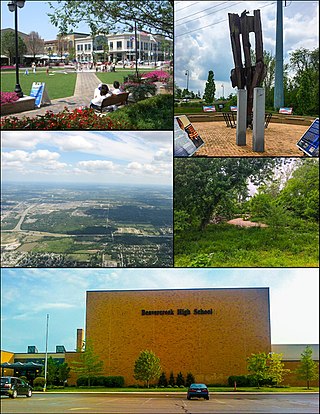
Beavercreek is the largest city in Greene County, Ohio, United States. The population was 46,549 at the 2020 census. Part of the Dayton metropolitan area, it is the second-largest suburb of Dayton.

<span class="mw-page-title-main">Lorain, Ohio</span> City in Ohio, United States

Lorain is a city in Lorain County, Ohio, United States. It is located in Northeast Ohio on Lake Erie at the mouth of the Black River, about 25 miles (40 km) west of Cleveland. As of the 2020 census, the city had a population of 65,211, making it Ohio's ninth-largest city, the third-largest in Greater Cleveland, and the largest in Lorain County by population.

<span class="mw-page-title-main">Girard, Ohio</span> City in Ohio, United States

Girard is a city in southern Trumbull County, Ohio, United States, along the Mahoning River. The population was 9,603 at the 2020 census. Located directly north of Youngstown, it is a suburb of the Youngstown–Warren metropolitan area.

<span class="mw-page-title-main">Pickerington, Ohio</span> City in Ohio, United States

Pickerington is a city in Fairfield and Franklin counties in the central region of the U.S. state of Ohio. It is a suburb of Columbus. The population was 23,094 at the 2020 census. It was founded in 1815 as Jacksonville, named after Andrew Jackson. The name was changed in 1827 in honor of its founder, Abraham Pickering. As land annexation, development, and immigration into the Columbus area continues, the city of Pickerington has generally followed suit. Pickerington is home to the Motorcycle Hall of Fame, located off of Interstate 70.

<span class="mw-page-title-main">Alliance, Ohio</span> City in Ohio, United States

Alliance is a city in eastern Stark County, Ohio, United States, with a small district lying in adjacent Mahoning County. The population was 21,672 as of the 2020 census. The city is approximately 16 miles (26 km) northeast of Canton, 27 miles (43 km) southwest of Youngstown and 51 miles (82 km) southeast of Cleveland.

References

  1. "ArcGIS REST Services Directory". United States Census Bureau. Retrieved September 20, 2022.
  2. 1 2 U.S. Geological Survey Geographic Names Information System: Maple Heights, Ohio
  3. 1 2 3 "U.S. Census website". United States Census Bureau . Retrieved January 31, 2008.
  4. "Ohio Museum of Transportation - Maple Heights Transit". www.omot.org. Retrieved June 14, 2021.
  5. "SOUTHGATE SHOPPING CENTER". Encyclopedia of Cleveland History | Case Western Reserve University. September 24, 2018. Retrieved June 14, 2021.
  6. RTA, Greater Cleveland (July 6, 2017). "History of public transit in Cleveland". Greater Cleveland Regional Transit Authority. Retrieved June 14, 2021.
  7. RTA, Greater Cleveland (April 2, 2013). "Southgate Transit Center". Greater Cleveland Regional Transit Authority. Retrieved June 14, 2021.
  8. "Ohio Auditor of State Keith Faber". ohioauditor.gov. Retrieved October 20, 2021.
  9. https://citymapleheights.com/download/mayor/2021-State-of-the-City.pdf [ bare URL PDF ]
  10. "Ohio Auditor of State Keith Faber". ohioauditor.gov. Retrieved June 14, 2021.
  11. 1 2 "GOJO announces addition of two new Northeast Ohio facilities to help meet demand for Purell". wkyc.com. June 9, 2020. Retrieved June 14, 2021.
  12. "US Gazetteer files 2010". United States Census Bureau. Archived from the original on January 25, 2012. Retrieved January 6, 2013.
  13. "Number of Inhabitants: Ohio" (PDF). 18th Census of the United States. U.S. Census Bureau. 1960. Retrieved May 17, 2020.
  14. "Ohio: Population and Housing Unit Counts" (PDF). U.S. Census Bureau. Retrieved November 22, 2013.
  15. "P2 Hispanic or Latino, and Not Hispanic or Latino by Race – 2010: DEC Redistricting Data (PL 94-171) – Maple Heights city, Ohio". United States Census Bureau .
  16. "P2 Hispanic or Latino, and Not Hispanic or Latino by Race – 2020: DEC Redistricting Data (PL 94-171) - Maple Heights city, Ohio". United States Census Bureau .
  17. "U.S. Census website". United States Census Bureau . Retrieved January 6, 2013.
  18. 1 2 "CHARTER OF THE CITY OF MAPLE HEIGHTS". American Legal Publishing Corporation. Retrieved October 20, 2021.
  19. Zicari, Peter; clevel; .com (November 4, 2015). "Cuyahoga County local results: Election 2015". cleveland. Retrieved June 15, 2021.
  20. "Maple Heights Mayor Is a First in More Ways Than One". spectrumnews1.com. Retrieved June 15, 2021.
  21. "SUMMARY REPORT | November 8, 2016 | Official Resultsaccess-date=2021-10-30". boe.cuyahogacounty.gov.
  22. "City Council Members". City of Maple Heights. Retrieved March 28, 2023.