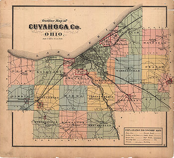
When Cuyahoga County was founded, it was divided into civil townships for purposes of rural government, as were other Ohio counties. By 1990, this county was the most urbanized county in Ohio,[1] and as a result, most of its townships have been annexed by the city of Cleveland or one of the other municipalities in Cuyahoga County. In Ohio, when the entirety of a civil township has been annexed by one or more municipalities, it ceases to have governmental powers and becomes a paper township, existing on maps, but possessing no governmental powers. Today, 19 of Cuyahoga County's townships are paper townships, with only a part of Olmsted Township and a tiny section of Chagrin Falls Township remaining as civil townships — just 10.5 square miles (27km2) of Cuyahoga County's total area of 458sqmi (1,190km2).[2]
Bedford Township
Although the land that became Bedford Township was bought by the Connecticut Land Company in 1795, no white settlers came until Elijah Nobles arrived in 1813, and the first permanent settler came only in 1821. The township was organized on April 7, 1823, and the city of Bedford was incorporated as a village on March 15, 1837. Throughout the rest of the century, the township remained an agricultural area with little industry, but major industries began to arrive in the early 20th century.[3]
In 1915, the first political change occurred in the township since 1837, when Maple Heights was incorporated as a village. The rest of the township remained unincorporated until 1951, when it was divided between Bedford Heights, Oakwood, and Walton Hills.[4] As of the 2000 census, these cities and villages had a total population of 57,812.[5]
Brecksville Township
Brecksville Township was formed in 1807 and named for Massachusetts resident John Breck, the owner of significant lands in that vicinity. It included the modern community of Brecksville and part of Broadview Heights. The township was first settled in 1811 by the family of one Seth Payne, who came from Williamsburg, Massachusetts, and who was soon followed by several other families. Its first school was founded in 1814, with its first teacher being one of Payne's daughters.[6] Within the township, the village of Brecksville was incorporated in 1921, and it gained the status of city in 1960.[7]
Brooklyn Township
Brooklyn Township was organized on June 1, 1818. In its early years, it extended northward to Lake Erie, but most of the township incorporated into or was annexed by municipalities, the last of which was the city of Brooklyn in the southwest. Today, the township is divided between the cities of Brooklyn and Cleveland] and the villages of Brooklyn Heights, Cuyahoga Heights, Linndale, and Newburgh Heights.[8]
Dover Township
In 1806, two residents of Dover, Connecticut purchased the northwestern corner township of Cuyahoga County and named it for their hometown. Although Europeans had visited the area before 1800, the first settlers did not arrive until 1810, a family from Vermont and a family from New York. The population grew rapidly; as early as the 1840 census, the township had a population of 960 people.
In the summer of 1901, the northern part of the township broke away and soon formed the village of Bay, which became Bay Village in 1950.[9] Meanwhile, the village of Dover had been incorporated to the south of Bay in 1911. It, too, changed its name, in 1940, to Westlake.[10] Today, most of the original Dover Township is divided between Bay Village and Westlake, although its southeastern portion has been part of North Olmsted since that village was incorporated in 1908.[8]
East Cleveland Township
East Cleveland Township was organized in 1847 from the eastern end of the 1796 Cleaveland Township and the western end of Euclid Township. Part of the township incorporated as the village (now city) of East Cleveland in 1895.[11] What had been this township today is divided between the village of Bratenahl parts of Cleveland, and the cities of Cleveland Heights, and East Cleveland.
Euclid Township
Euclid Township spanned the territory of Cuyahoga County from Lake Erie to Cedar Road and East 140th Street to the Lake County line. Named for the ancient Greek mathematician, it was surveyed and named in 1796 during the first Connecticut Land Company expedition to the Western Reserve led by Moses Cleaveland. Its first pioneer settlers were John Moss, then Joseph and Chloe Burke in 1798, Timothy and Mary Doan in 1801, and David and Mary Dille and Asa and Frances Dille in 1803, plus many of their children. A large wave of settlers primarily of the extended McIlrath family began to arrive in Euclid Township in 1804. The early economy was based on farming, although it soon included gristmills, sawmills and boat building, and in later years grapes, railroads, stone quarries and industry became important. Its original territory was the site of Standard Oil billionaire John D. Rockefeller's Forest Hill country estate, and was the birthplace of General Electric co-founder Charles F. Brush. Euclid Beach Park once brought roller coaster enthusiasts to its shore. In 1908 the Collinwood School Fire killed 172 students, two teachers and one rescuer at the Lake View School. The township became defunct in 1917 when the last of its territory became part of incorporated villages. Today its land is divided among the Cleveland neighborhoods of Collinwood and Nottingham, and the cities of Cleveland Heights, East Cleveland, Euclid, Lyndhurst, Richmond Heights, and South Euclid.[12]
Independence Township
Independence Township's earliest history was destroyed by a fire. In its early years, the township was primarily agricultural, but by 1850, it possessed nationally recognized quarries. The city of Independence incorporated much of Independence Township as a village in 1914,[13] and the rest of the township was incorporated as the village of Seven Hills in 1927.[14] Today, Independence Township is divided between Brooklyn Heights, Cuyahoga Heights, Garfield Heights, Independence, Seven Hills, and Valley View.
Mayfield Township
Mayfield Township
Mayfield Township was organized in 1819, being split off from Chagrin Township. It existed until 1920, when the entire township was incorporated into several villages: Gates Mills, Highland Heights, Mayfield Village, and Riverside. Since then, these municipalities have changed: Mayfield Heights left Mayfield Village in 1925, Riverside joined Gates Mills in the late 1920s, and Lyndhurst annexed a small portion of the township.[15]
Middleburg Township
Middleburg Township, named for Middleburg, New York, was first settled in the summer of 1809. For several decades, few people lived in the area, which was covered with swamps and heavy forests. Significant development began in 1842, when the first quarry was developed in the southwestern part of the township. After 1850, when Berea was incorporated in the southwestern part of the township, the rest of the township was improved so as to make it more appealing to settlement, and a few industries were founded. The township was further reduced by the incorporation of Brook Park in 1914, and the remaining unincorporated areas were incorporated as Middleburg Heights in 1927. Today, the township is divided between four different cities:
Newburgh Township was organized on 15 October 1814, some years after the settlement of Newburgh had been established. Originally, the area's natural resources were significant enough that Newburg was the leading settlement in Cuyahoga County, causing Cleveland to be referred to as "the town on the lake, six miles from Newburgh," although Cleveland's location on Lake Erie soon led to its dominance.[17] Cleveland first annexed part of Newburgh Township in 1867 and continued to expand through the next several decades, eventually absorbing the village of Newburgh and most of the rest of the township by 1905.[18] The village of Newburgh Heights was incorporated in 1904, although it has since been reduced in area significantly.[19] Today, Newburg Township is divided between four cities and three villages: Brooklyn Heights, Cleveland, Cleveland Heights, Cuyahoga Heights, Garfield Heights, Newburgh Heights, and Shaker Heights.[20]
Parma Township, named for Parma, New York, was organized in 1826, 10 years after the first settlers arrived from New York. The township was long a farming region, with its only industry being a clockmaker's shop. In 1911, part of the western region of the township was incorporated as Parma Heights, and the rest was incorporated as Parma in 1924.[22] In 2000, what was once Parma Township had a population of 107,314.[5]
Riveredge Township
Riveredge Township was organized in 1926 by residents of Brook Park, who disagreed with the village's course and seceded. It was always a very small township; even after expansion in 1932, it had an area of only 48 acres (19 ha). The township changed over the years; it was originally primarily a truck farm, became a trailer park in the 1950s, and expanded greatly in the 1960s. However, the township was purchased in 1983 by Cleveland Hopkins International Airport, and it has been virtually uninhabited since 1986.[23] Riveredge Township was officially dissolved on July 1, 1992, when it was divided by the cities of Cleveland and Fairview Park.[24]
Rockport Township
Located on the shoreline of Lake Erie,[25] Rockport Township was organized on February 24, 1819. In its early years, many farms covered the township. Today, the township's original area is divided between several municipalities: Cleveland, a small portion of Brook Park, Fairview Park, Lakewood (incorporated as a village on August 31, 1889[26]), Linndale, and Rocky River.[27]
Royalton Township
Royalton Township was formed on October 27, 1818, seven years after the first settlers arrived in the area. It was named after Royalton, Vermont, the hometown of two of the township's earliest settlers. Only one village was incorporated in the township, Royalton Center. For some time, the township was an important center of agriculture, especially dairying. To avoid confusion with another Royalton Township in northwest Ohio and another Royalton village in southeastern Ohio, its name was changed to North Royalton Township in 1881. The township ceased to exist in April 1927, when it incorporated into the village of North Royalton.[28] The township is now divided between most of North Royalton and the western half of Broadview Heights.
Solon Township
Solon Township was named for Isaac Solon Bull, the son of one of the first settlers. The township was first settled in 1820, although development was retarded by the swampland common in the area. By 1850, the swamps had been drained, leaving rich farmland. The village of Solon was incorporated in 1917 and became a city in 1961,[29] while Glenwillow was first settled in 1893.[30] Today, the entire township is occupied by one of these two municipalities, and in 2000, it had a population of 22,697.[5]
Strongsville Township
Strongsville Township was organized in 1818 and named for John Strong, an early pioneer who came from Vermont. By 1820, the township had a population of 297. Agriculture was long the mainstay of the township's economy, although sawmills, a quarry, and a plant for manufacturing bricks were opened in the early years. Except for a small part that was annexed by Berea, the township was eventually entirely incorporated into Strongsville, which was incorporated in 1927 and became a city in 1960.[31] In 2000, Strongsville had a population of 43,858.[5]
Warrensville Township
Warrensville Township was formed in 1814, several years after the first attempts at settlement. The first permanent settler in Warrensville Township was Daniel Warren, formerly of New Hampshire, who came with his family in 1810, and after whom the township is named. In 1822, members of the Shakers organized the North Union Shaker Community in the township in present-day Shaker Heights. It endured until 1888, by which time the community had become too small to be viable. Their land was eventually purchased in 1904 by developers who quickly arranged for the construction of subdivisions in the township.[32]
The village of Beachwood was incorporated in Warrensville Township on June 26, 1915.[33] As the Cleveland metropolitan area expanded, parts of Warrensville Township were divided among Orange, Shaker Heights, University Heights, and Warrensville Heights.[34] In 1990, Warrensville Township became a paper township when its last unincorporated area was incorporated as the village of Highland Hills.[35] The township is now divided between Cleveland, Garfield Heights, Highland Hills, Orange, Shaker Heights, Beachwood, Warrensville Heights, North Randall, University Heights, and Cleveland Heights.
West Park Township
West Park Township was a small, short-lived township that was split from Rockport Township in 1900. Historically, the area had been poor and underdeveloped, leading to its nickname of the "lost city". The township lasted little more than 20 years, as it was annexed to the city of Cleveland in 1923. Today, West Park comprises four westside neighborhoods of Cleveland: Jefferson, Kamm's Corners, Puritas-Longmead, and Hopkins (formerly called Riverside).[36]
Related Research Articles
Cuyahoga County is a large urban county located in the northeastern part of the U.S. state of Ohio. The county seat and largest city is Cleveland. As of the 2020 census, its population was 1,264,817, making it the second-most populous county in the state.
Brecksville is a city in southern Cuyahoga County, Ohio, United States. The city's population was 13,635 at the 2020 census. It is a suburb of Cleveland and is included in the Cleveland-Akron-Canton Combined statistical area.
Broadview Heights is a city in southern Cuyahoga County, Ohio, United States. The city's population was 19,936 at the 2020 census. A suburb of Cleveland, it is part of the Cleveland metropolitan area.
Shaker Heights is a city in Cuyahoga County, Ohio, United States. As of the 2020 census, the city's population was 29,439. Shaker Heights is an inner-ring streetcar suburb of Cleveland, abutting the eastern edge of the city's limits. It is a planned community developed by the Van Sweringen brothers, railroad moguls who envisioned the community as a suburban retreat from the industrial inner city of Cleveland.
South Euclid is a city in Cuyahoga County, Ohio, United States. It is an inner-ring suburb of Cleveland located on the city's east side. As of the 2020 census, the population was 21,883.
The Cleveland metropolitan area, or Greater Cleveland as it is more commonly known, is the metropolitan area surrounding the city of Cleveland in Northeast Ohio, United States. According to the 2020 census results, the six-county Cleveland, OH Metropolitan Statistical Area (MSA) consists of Cuyahoga County, Ashtabula County, Geauga County, Lake County, Lorain County, and Medina County, and has a population of 2,185,825, making it the 33rd-most populous metropolitan area in the United States and the third largest metropolitan area in Ohio. The metro area is also part of the larger Cleveland–Akron–Canton Combined Statistical Area with a population of over 3.7 million people, the most populous statistical area in Ohio and the 17th most populous in the United States.
The Greater Cleveland Regional Transit Authority is the public transit agency for Cleveland, Ohio, United States and the surrounding suburbs of Cuyahoga County. RTA is the largest transit agency in Ohio, with a ridership of 22,431,500, or about 75,300 per weekday as of the fourth quarter of 2023.
Coventry Village is a commercial business district in Cleveland Heights, Ohio, situated on Coventry Road between Mayfield Road and Euclid Heights Boulevard. Coventry is associated with Northeast Ohio's artistic, musical, bohemian, hippie and emerging hipster communities and is the center of Cleveland's creative class, inviting comparisons to the Haight-Ashbury district in San Francisco and Greenwich Village in New York City, although on a smaller scale.
Cleveland Metroparks is an extensive system of nature preserves in Greater Cleveland, Ohio. Eighteen reservations, which largely encircle the city of Cleveland, follow along the shore of Lake Erie and the rivers and creeks that flow through the region. Referred to unofficially as the 'Emerald Necklace', the network of parks spans over 25,000 acres (10,000 ha) and includes over 300 miles (480 km) of walking, bicycle, and horse trails as well as numerous picnic areas, nature education centers, golf courses, and countless fishing spots. In addition, the district includes the zoo in Cleveland. Four of the reservations are adjacent to Cuyahoga Valley National Park.
Sun Newspapers was formed as a chain of weekly newspapers serving Northeast Ohio. Prior to a major reorganization in 2013, the chain consisted of 11 weekly newspapers serving 49 different communities in Greater Cleveland. The papers are focused on suburbs and exurbs in Cuyahoga, Geauga, Lorain and Medina counties. Its offices are in Valley View.
Area code 216 is the telephone area code in the North American Numbering Plan (NANP) for the city of Cleveland and most of its inner-ring suburbs in Cuyahoga County of the U.S. state of Ohio. The area code is one of the original North American area codes established in 1947.
Cuyahoga County Public Library (CCPL) has 27 branches that serve 47 communities in Cuyahoga County, Ohio. It was ranked the number one public library in the United States among libraries serving populations of more than 500,000 by the Hennen's American Public Library Ratings 2010. In 2022, more than 10 million items were borrowed by its 737,702 cardholders, and 2.99 million visits were made to branches.
The Northeast Ohio Conference (NOC) was a high school athletics conference, recognized by the Ohio High School Athletic Association (OHSAA), in northeast Ohio. Eighteen member schools — each located within the Northeast District of the OHSAA — competed in three six-member divisions: Valley, River and Lake. Dan Gerome served as the last NOC commissioner. Anthony J. Paletta designed the conference logo in 2006.
This is a list of the National Register of Historic Places listings in Cleveland, Ohio.
Kingsbury Run is the name that refers to an area on the southeast side of Cleveland, Ohio, located near the suburb of Shaker Heights. The area stretches westward through Kinsman Road. It contained a natural watershed that ran through East 79th Street and carried storm waters into the Cuyahoga River, draining them from the areas now known as Maple Heights and Warrensville Heights. Kingsbury Run was named after James Kingsbury (1767–1847), one of the earliest settlers in the Western Reserve, who became the first inhabitant of Newburgh in 1797. It is also the route through which the RTA Rapid Transit travels on its way to Public Square in downtown Cleveland.
The Greater Cleveland Conference is an active OHSAA athletic league that originally existed from 1950 to 1998, then re-formed to begin play in the 2015–2016 school year.
West Park is a historical area on the West Side of Cleveland, Ohio. Once an independent municipality, it was annexed by Cleveland after a referendum in 1923. The area covers 12.5 square miles and is bounded by West 117th Street to the east, the Rocky River Valley to the west, Brookpark Road to the South, and the streetcar suburb of Lakewood to the north. The Cleveland City Planning Commission traditionally divides West Park into four neighborhoods: Jefferson, Kamm's Corners, Bellaire–Puritas, and Hopkins.
This is a list of high school athletic conferences in the Northeast Region of Ohio, as defined by the OHSAA. Because the names of localities and their corresponding high schools do not always match and because there is often a possibility of ambiguity with respect to either the name of a locality or the name of a high school, the following table gives both in every case, with the locality name first, in plain type, and the high school name second in boldface type. The school's team nickname is given last.
This is a list of former high school athletic conferences in the Northeast Region of Ohio, as designated by the OHSAA. If a conference had members that span multiple regions, the conference is placed in the article of the region most of its former members hail from. Because the names of localities and their corresponding high schools do not always match and because there is often a possibility of ambiguity with respect to either the name of a locality or the name of a high school, the following table gives both in every case, with the locality name first, in plain type, and the high school name second in boldface type. The school's team nickname is given last.
Union–Miles Park is a neighborhood on the Southeast side of Cleveland, Ohio, in the United States. The neighborhood draws its name from Union Avenue, and Miles Park in its far southwest corner.
This page is based on this Wikipedia article Text is available under the CC BY-SA 4.0 license; additional terms may apply. Images, videos and audio are available under their respective licenses.


