Parma, New York

Last updated

Parma
Monroe CR 185 in Parma NY.jpg
Monroe County Route 185 (Parma Center Road) eastbound entering the town of Parma.
Monroe County New York incorporated and unincorporated areas Parma highlighted.svg
Location in Monroe County and the state of New York.
New York in United States (US48).svg
Location of New York in the United States
Coordinates: 43°15′N77°47′W / 43.250°N 77.783°W / 43.250; -77.783
CountryUnited States
State New York
County Monroe
EstablishedApril 8, 1808;216 years ago (1808-04-08) [1]
Government
   Town Supervisor Peter N. McCann (R) First elected 2009
  • Carmey R. Carmestro (R)
  • James M. Smith (R)
  • Gary L. Comardo (R)
  • James Roose (R)
Area
[2]
  Total42.98 sq mi (111.33 km2)
  Land42.02 sq mi (108.84 km2)
  Water0.96 sq mi (2.49 km2)
Elevation
325 ft (99 m)
Population
 (2020)
  Total16,217
  Density385.94/sq mi (149.00/km2)
Time zone UTC-5 (EST)
  Summer (DST) UTC-4 (EDT)
ZIP code
14468
Area code 585
FIPS code 36-055-56561
Website http://www.parmany.org/

Parma is a town in Monroe County, New York, United States. The population was 16,217 at the 2020 census. [3]

Contents

The Town of Parma, then in Genesee County, was organized in 1808, named after Parma in Italy.

Geography

According to the United States Census Bureau, the town has a total area of 42.9 square miles (111 km2), of which 42.0 square miles (109 km2) is land and 1.0 square mile (2.6 km2) (2.28%) is water.

The town is bordered on the north by the southern shore of Lake Ontario, on the west by the towns of Hamlin, Clarkson and Sweden, on the south by the town of Ogden and on the east by the town of Greece.

Demographics

Historical population
CensusPop.Note
1820 1,342
1830 2,63996.6%
1840 2,6520.5%
1850 2,94711.1%
1860 2,904−1.5%
1870 2,864−1.4%
1880 3,18011.0%
1890 2,912−8.4%
1900 2,814−3.4%
1910 2,9545.0%
1920 2,923−1.0%
1930 3,22210.2%
1940 3,3875.1%
1950 4,04919.5%
1960 6,27755.0%
1970 10,74871.2%
1980 12,58517.1%
1990 13,87310.2%
2000 14,8226.8%
2010 15,6335.5%
2020 16,2173.7%
U.S. Decennial Census [4] [3]

As of the census [5] of 2000, there were 14,822 people, 5,283 households, and 4,030 families residing in the town. The population density was 353.2 inhabitants per square mile (136.4/km2). There were 5,502 housing units at an average density of 131.1 per square mile (50.6/km2). The racial makeup of the town was 97.08% White, 1.29% African American, 0.18% Native American, 0.52% Asian, 0.03% Pacific Islander, 0.24% from other races, and 0.67% from two or more races. Hispanic or Latino of any race were 1.12% of the population.

There were 5,283 households, out of which 38.7% had children under the age of 18 living with them, 64.1% were married couples living together, 8.4% had a female householder with no husband present, and 23.7% were non-families. 18.9% of all households were made up of individuals, and 6.2% had someone living alone who was 65 years of age or older. The average household size was 2.77 and the average family size was 3.20.

In the town, the population was spread out, with 28.3% under the age of 18, 6.6% from 18 to 24, 30.2% from 25 to 44, 24.8% from 45 to 64, and 10.0% who were 65 years of age or older. The median age was 37 years. For every 100 females, there were 98.8 males. For every 100 females age 18 and over, there were 96.4 males.

The median income for a household in the town was $53,189, and the median income for a family was $60,686. Males had a median income of $42,566 versus $29,381 for females. The per capita income for the town was $22,431. About 2.2% of families and 4.1% of the population were below the poverty line, including 5.6% of those under age 18 and 5.0% of those age 65 or over.

History

The Town of Parma was established on April 8, 1808, from the town of Northampton, named after Parma, Italy.

Government

Parma town hall Parma, New York town hall.jpg
Parma town hall

The town is governed by a Town Board consisting of a Town Supervisor and four Councilpersons, all elected by registered town voters.

Public school

The Hilton Central School District comprises the majority of the town with the southern portion along the 104 Corridor in the Spencerport Central School District and a southwestern portion in the Brockport Central School District. http://www.hilton.k12.ny.us

Communities and locations in Parma

Notable people

Related Research Articles

<span class="mw-page-title-main">Monroe, Adams County, Indiana</span> Town in Indiana, United States

Monroe is a town in Washington and Monroe townships, Adams County, Indiana, United States. The population of the town was 945 residents at the 2019 census. Adams Central Community Schools is located in Monroe.

<span class="mw-page-title-main">Monrovia, Indiana</span> Town in Indiana, United States

Monrovia is a town in Monroe Township, Morgan County, in the U.S. state of Indiana. The population was 1,643 at the 2020 census, up from 1,063 in 2010.

<span class="mw-page-title-main">Paragon, Indiana</span> Town in Indiana, United States

Paragon is a town in Ray Township, Morgan County, in the U.S. state of Indiana. The population was 556 at the 2020 census, down from 659 in 2010.

<span class="mw-page-title-main">Monroe, Maine</span> Town in the state of Maine, United States

Monroe is a town in Waldo County, Maine, United States named for President James Monroe. The population was 931 at the 2020 census.

<span class="mw-page-title-main">Hatley, Mississippi</span> Town in Mississippi, United States

Hatley is a town in Monroe County, Mississippi. The population was 495 at the 2020 census.

<span class="mw-page-title-main">Old Monroe, Missouri</span> City in Lincoln County, Missouri, US

Old Monroe is a city in Lincoln County, Missouri, United States. The population was 249 at the 2020 census.

<span class="mw-page-title-main">Hamlin, New York</span> Town in New York, United States

Hamlin is a town in Monroe County, New York, United States. The population was 8,725 at the 2020 census.

<span class="mw-page-title-main">Hilton, New York</span> Village in New York, United States

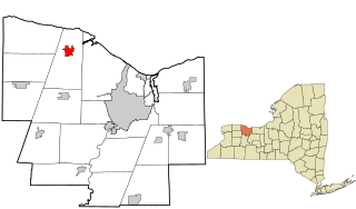
Hilton is a village in Monroe County, New York, United States. The population was 6,027 at the 2020 census. The community was named for the Rev. Charles A. Hilton.

<span class="mw-page-title-main">Ogden, New York</span> Town in New York, United States

Ogden is a town in Monroe County, New York, United States. The population was 20,270 at the 2020 census.

<span class="mw-page-title-main">Sweden, New York</span> Town in New York, United States

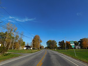
Sweden is a town in Monroe County, New York, United States. It is part of the Rochester metropolitan area, New York. This town is located on the west border of the county. The Erie Canal passes through the northern part of the town and Route 19 is a major north–south highway. The population was 13,244 at the 2020 census.

<span class="mw-page-title-main">Walton Park, New York</span> CDP in New York, United States

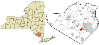
Walton Park is a census-designated place (CDP) in Orange County, New York, United States. As of the 2020 census, the CDP had a total population of 3,907. Walton Park is on the town line separating the towns of Chester and Monroe. Street addresses within Walton Park are usually assigned to Monroe, not Chester.

<span class="mw-page-title-main">West Monroe, New York</span> Town in New York, United States

West Monroe is a town in Oswego County, New York, United States. The population was 4,252 at the 2010 census.

<span class="mw-page-title-main">Adrian, Wisconsin</span> Town in Wisconsin, United States

The Town of Adrian is located in Monroe County, Wisconsin, United States. The population was 682 at the 2000 Census. The unincorporated communities of Jacksonville and Scotts Junction are located in the town.

<span class="mw-page-title-main">Byron, Monroe County, Wisconsin</span> Town in Wisconsin, United States

Byron is a town in Monroe County, Wisconsin, United States. The population was 1,394 at the 2000 census. The unincorporated communities of Shennington and Valley Junction are located in the town.

<span class="mw-page-title-main">Glendale, Monroe County, Wisconsin</span> Town in Wisconsin, United States

Glendale is a town in Monroe County, Wisconsin, United States. The population was 579 at the 2000 census. The unincorporated community of Glendale is located in the town.

<span class="mw-page-title-main">La Grange, Monroe County, Wisconsin</span> Town in Wisconsin, United States

La Grange is a town in Monroe County, Wisconsin, United States. The population was 1,761 at the 2000 census.

<span class="mw-page-title-main">Portland, Monroe County, Wisconsin</span> Town in Wisconsin, United States

The Town of Portland is located in Monroe County, Wisconsin, United States. The population was 686 at the 2000 census. According to a census taken in 2021,the population was 202, 35.8 square mile with about 26.6 people per square mile

<span class="mw-page-title-main">Ridgeville, Wisconsin</span> Town in Wisconsin, United States

The Town of Ridgeville is located in Monroe County, Wisconsin, United States. The population was 491 at the 2000 census.

<span class="mw-page-title-main">Scott, Monroe County, Wisconsin</span> Town in Wisconsin, United States

The Town of Scott is located in Monroe County, Wisconsin, United States. The population was 117 at the 2000 census. The unincorporated community of Norway Ridge is located in the town.

<span class="mw-page-title-main">Greece, New York</span> Town in Monroe County, New York, United States

Greece is a town in Monroe County, New York, United States. A suburb of Rochester, New York, it is the largest town by population in Monroe County, and the second-largest municipality by population in the county, behind only the City of Rochester. As of April, 2020, the town has a population of 96,926.

References

  1. Hanford, Franklin (1911). On the origin of the names of places in Monroe County, New York (PDF). Scottsville, New York: Isaac Van Hooser. p. 10. OCLC   866011722 . Retrieved December 2, 2021.
  2. "2016 U.S. Gazetteer Files". United States Census Bureau. Retrieved July 5, 2017.
  3. 1 2 "QuickFacts: Parma town, Monroe County, New York". United States Census Bureau. Retrieved December 19, 2023.
  4. "Census of Population and Housing". Census.gov. Retrieved June 4, 2015.
  5. "U.S. Census website". United States Census Bureau . Retrieved January 31, 2008.