Brighton (CDP), New York

Last updated

Brighton
USA New York location map.svg
Red pog.svg
Brighton
Coordinates: 43°07′24″N77°34′05″W / 43.12333°N 77.56806°W / 43.12333; -77.56806
CountryUnited States
State New York
County Monroe
Area
[1]
  Total15.60 sq mi (40.40 km2)
  Land15.41 sq mi (39.90 km2)
  Water0.19 sq mi (0.50 km2)
Elevation
490 ft (150 m)
Population
 (2020)
  Total37,137
  Density2,410.40/sq mi (930.64/km2)
Time zone UTC-5 (EST)
  Summer (DST) UTC-4 (EDT)
Area code 585
FIPS code 36-08257

Brighton is a census-designated place (CDP) in Monroe County, New York, United States. The population was 36,609 at the 2010 census. The CDP takes its name from locations in the county.

Contents

Town of Brighton, which is conterminously with the CDP, is a town south of the City of Rochester. The town has a community, also named Brighton, a suburb of Rochester.

Geography

According to the United States Census Bureau, the CDP has a total area of 15.6 square miles (40.5 km2), of which 15.4 square miles (40.0 km2) is land and 0.2 square mile (0.4 km2) (1.09%) is water.

Demographics

Historical population
CensusPop.Note
1980 35,776
1990 34,455−3.7%
2000 35,5843.3%
2020 37,137
source: [2]

As of the census [3] of 2000, there were 35,584 people, 15,852 households, and 8,686 families residing in the CDP. The population density was 2,303.6 inhabitants per square mile (889.4/km2). There were 16,703 housing units at an average density of 1,081.3 per square mile (417.5/km2). The racial makeup of the CDP was 86.09% White, 3.70% Black or African American, 0.10% Native American, 8.13% Asian, 0.03% Pacific Islander, 0.63% from other races, and 1.33% from two or more races. Hispanic or Latino of any race were 2.34% of the population.

There were 15,852 households, out of which 24.7% had children under the age of 18 living with them, 45.9% were married couples living together, 6.8% had a female householder with no husband present, and 45.2% were non-families. 36.3% of all households were made up of individuals, and 13.8% had someone living alone who was 65 years of age or older. The average household size was 2.14 and the average family size was 2.86.

In the CDP, the population was spread out, with 20.0% under the age of 18, 7.5% from 18 to 24, 29.9% from 25 to 44, 23.4% from 45 to 64, and 19.1% who were 65 years of age or older. The median age was 40 years. For every 100 females, there were 88.8 males. For every 100 females age 18 and over, there were 84.9 males.

The median income for a household in the CDP was $52,066, and the median income for a family was $70,436. Males had a median income of $46,292 versus $35,171 for females. The per capita income for the CDP was $32,642. About 3.0% of families and 6.1% of the population were below the poverty line, including 4.9% of those under age 18 and 5.2% of those age 65 or over.

Related Research Articles

<span class="mw-page-title-main">Moores Mill, Alabama</span> Census-designated place in Alabama, United States

Moores Mill is an unincorporated community and census-designated place (CDP) in Madison County, Alabama, United States, and is included in the Huntsville-Decatur Combined Statistical Area. The population was 6,729 at the 2020 census, up from 5,682 at the 2010 census.

<span class="mw-page-title-main">East Sahuarita, Arizona</span> Community in Pima County, Arizona

East Sahuarita was a census-designated place (CDP) in Pima County, Arizona, United States. The population was 1,419 at the 2000 census. The CDP comprises the unincorporated neighborhoods east of incorporated Sahuarita.

<span class="mw-page-title-main">Summit, Arizona</span> CDP in Pima County, Arizona

Summit is a census-designated place (CDP) in Pima County, Arizona, United States. The population was 3,702 at the 2000 census.

<span class="mw-page-title-main">Fairview, California</span> CDP in California, United States

Fairview is a census-designated place (CDP) in Alameda County, California, United States. It borders on the city of Hayward and the census-designated place of Castro Valley. The population was 11,341 at the 2020 census.

<span class="mw-page-title-main">Waverly, Florida</span> Census-designated place in Florida, United States

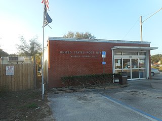
Waverly is a census-designated place (CDP) in east-central Polk County, Florida, United States. The population was 1,927 at the 2000 census. It is part of the Lakeland–Winter Haven Metropolitan Statistical Area.

<span class="mw-page-title-main">Lakewood Shores, Illinois</span> Census-designated place in Illinois, United States

Lakewood Shores is a census-designated place (CDP) in Will County, Illinois, United States. The population was 665 at the 2020 census.

<span class="mw-page-title-main">Gates, New York</span> Town in New York, United States

Gates is a town in Monroe County, New York, United States. The town is named after General Horatio Gates. The population was 28,400 at the 2010 census. Gates and North Gates are census-designated places located within the town's boundaries. It is a suburb of nearby Rochester, New York.

<span class="mw-page-title-main">Cherry Grove, Ohio</span> Census-designated place in Ohio, United States

Cherry Grove is a census-designated place (CDP) in Anderson Township, Hamilton County, Ohio, United States. The population was 4,419 at the 2020 census.

<span class="mw-page-title-main">Choctaw Lake, Ohio</span> CDP in Ohio, United States

Choctaw Lake is a census-designated place (CDP) in Madison County, Ohio, United States. The population was 2,047 at the 2020 census.

<span class="mw-page-title-main">East Berwick, Pennsylvania</span> Census-designated place in Pennsylvania, United States

East Berwick is a census-designated place (CDP) in Salem Township, Luzerne County, Pennsylvania, United States. The population was 2,007 at the 2010 census.

Forestville is a census-designated place (CDP) in Schuylkill County, Pennsylvania, United States. The population was 431 at the 2000 census.

Fountain Springs is a census-designated place in Butler Township, Schuylkill County, Pennsylvania, United States. The population was 100 at the 2000 census.

<span class="mw-page-title-main">Baidland, Pennsylvania</span> Census-designated place in Pennsylvania, United States

Baidland is a census-designated place (CDP) in Washington County, Pennsylvania, United States. The population was 1,563 at the 2010 census.

<span class="mw-page-title-main">Green Valley, South Dakota</span> CDP in South Dakota, United States

Green Valley is a census-designated place (CDP) and unincorporated community in Pennington County, South Dakota, United States. The population was 1,051 at the 2020 census.

<span class="mw-page-title-main">Chief Lake, Wisconsin</span> CDP in Wisconsin, United States

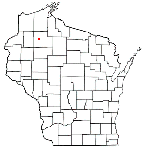
Chief Lake is a census-designated place (CDP) in the town of Hayward, Sawyer County, Wisconsin, United States. The population was 583 at the 2010 census.

Greece is a suburban community and census-designated place in Monroe County, New York, United States. The population was 14,519 at the 2010 census. Google Maps only shows that part of Greece.

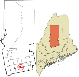
Lincoln is a census-designated place (CDP) consisting of the primary settlement in the town of Lincoln in Penobscot County, Maine, United States. The population was 2,884 at the 2010 census.

<span class="mw-page-title-main">Dover-Foxcroft (CDP), Maine</span> CDP in Maine, United States

Dover-Foxcroft is a census-designated place (CDP) in the town of Dover-Foxcroft in Piscataquis County, Maine, United States. The population was 2,592 at the 2000 census.

<span class="mw-page-title-main">Milo (CDP), Maine</span> CDP in Maine, United States

Milo is a census-designated place (CDP) in the town of Milo in Piscataquis County, Maine, United States. The population was 1,898 at the 2000 census.

Bingham is a census-designated place (CDP) in the town of Bingham in Somerset County, Maine, United States. The population was 856 at the 2000 census.

References

  1. "ArcGIS REST Services Directory". United States Census Bureau. Retrieved September 20, 2022.
  2. "CENSUS OF POPULATION AND HOUSING (1790-2000)". U.S. Census Bureau . Retrieved July 17, 2010.
  3. "U.S. Census website". United States Census Bureau . Retrieved January 31, 2008.