Churchville, New York

Last updated

Churchville
Village of Churchville
Monroe County New York incorporated and unincorporated areas Churchville highlighted.svg
Location in Monroe County and the state of New York.
New York in United States (US48).svg
Location of New York in the United States
Coordinates: 43°06′20″N77°52′50″W / 43.10556°N 77.88056°W / 43.10556; -77.88056
CountryUnited States
State New York
County Monroe
Town Riga
Founded1806
IncorporatedMarch 7, 1855 [1]
Named for Samuel Church
Government
  MayorJohn T. Hartman
  Deputy MayorDiane Pusateri
Area
[2]
  Total1.21 sq mi (3.13 km2)
  Land1.19 sq mi (3.08 km2)
  Water0.02 sq mi (0.05 km2)
Elevation
577 ft (176 m)
Population
 (2020)
  Total2,091
  Density1,757.14/sq mi (678.17/km2)
Time zone UTC-5 (EST)
  Summer (DST) UTC-4 (EDT)
ZIP code
14428
Area code 585
FIPS code 36-15638
Website http://www.churchville.net/

Churchville is a village in Monroe County, New York, United States. According to the 2010 census, the population was 1,961. The village is named after Samuel Church, an early settler. [3]

Contents

The village is west of the City of Rochester in the north part of the Town of Riga. It is at the intersection of Routes 33 and 36, north of Interstate 490.

Churchville Park and golf course are north of the village near Hutton Circle and Kendall Road.

History

In 1806, Samuel Church purchased the land that would become Churchville in what was known as West Pulteney. The village was incorporated on September 21, 1852, and named after Samuel Church, who owned all the land within the village limits. [3]

Geography

Churchville is at 43°6′20″N77°52′50″W / 43.10556°N 77.88056°W / 43.10556; -77.88056 (43.105462, -77.880533). [4]

According to the United States Census Bureau, the village has an area of 1.1 square miles (2.8 km2).

Demographics

Historical population
CensusPop.Note
1880 513
1890 493−3.9%
1900 5052.4%
1910 56511.9%
1920 513−9.2%
1930 65227.1%
1940 601−7.8%
1950 75525.6%
1960 1,00332.8%
1970 1,0656.2%
1980 1,39931.4%
1990 1,73123.7%
2000 1,8879.0%
2010 1,9613.9%
2020 2,0916.6%
U.S. Decennial Census [5]

As of the census [6] of 2000, the village had 1,887 people, 723 households, and 514 families. The population density was 1,662.7 inhabitants per square mile (642.0/km2). There were 753 housing units at an average density of 663.5 per square mile (256.2/km2). The village's racial makeup was 96.34% White, 0.74% African American, 0.11% Native American, 0.90% Asian, 0.05% from other races, and 1.85% from two or more races. Hispanic or Latino of any race were 0.42% of the population.

There were 723 households, out of which 36.9% had children under the age of 18 living with them, 58.5% were married couples living together, 9.7% had a female householder with no husband present, and 28.8% were non-families. 24.8% of all households were made up of individuals, and 10.7% had someone living alone who was 65 years of age or older. The average household size was 2.59 and the average family size was 3.10.

In the village, the population was spread out, with 27.6% under the age of 18, 6.6% from 18 to 24, 31.9% from 25 to 44, 22.8% from 45 to 64, and 11.0% who were 65 years of age or older. The median age was 36 years. For every 100 females, there were 90.8 males. For every 100 females age 18 and over, there were 85.1 males.

The village's median household income was $55,357, and the family median income was $63,333. Males had a median income of $45,667 versus $31,563 for females. The village's per capita income was $23,190. About 2.8% of families and 4.2% of the population were below the poverty line, including 3.0% of those under age 18 and 10.7% of those age 65 or over.

Main Street, 1895 Churchville1895.JPG
Main Street, 1895

Education

Churchville is served by the Churchville-Chili Central School District. [7]

Government

Churchville village offices Churchville, New York village offices.jpg
Churchville village offices

As of April 2024, the village is governed by Mayor John T. Hartman, Deputy Mayor Diane Pusateri, and three trustees: Michael Brown, Scott Cullen, Julie Michalko. [8]

The village conveens a planning board every second wednesday of each month, as well as a zoning board of appeals every 4 months or as necessary. [9] [10]

Noted residents

Related Research Articles

<span class="mw-page-title-main">Stone Park, Illinois</span> Village in Illinois, United States

Stone Park is a village in Cook County, Illinois, United States. The population was 4,576 at the 2020 census. Incorporated in 1939, the town was named for insurance magnate Clement Stone, who bought most of the land when it was still corn fields.

<span class="mw-page-title-main">St. David, Illinois</span> Village in Illinois, United States

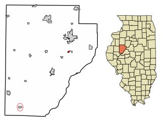
St. David is a village in Fulton County, Illinois, United States. The population was 522 at the 2020 census.

<span class="mw-page-title-main">Monmouth, Iowa</span> City in Iowa, United States

Monmouth is a city in Jackson County, Iowa, United States. The population was 129 at the time of the 2020 census.

<span class="mw-page-title-main">Attica Township, Michigan</span> Civil township in Michigan, United States

Attica Township is a civil township of Lapeer County in the U.S. state of Michigan. The population was 4,706 at the 2020 Census.

<span class="mw-page-title-main">Maple Plain, Minnesota</span> City in Minnesota, United States

Maple Plain is a city in Hennepin County, Minnesota, United States. The population was 1,768 at the 2010 census.

<span class="mw-page-title-main">Chili, New York</span> Town in New York, United States

Chili is a town in Monroe County, New York, United States. The population was 29,123 at the 2020 census. It is a suburb of the city of Rochester.

<span class="mw-page-title-main">Riga, New York</span> Town in New York, United States

Riga is a town in Monroe County, New York, United States. The population was 5,590 at the 2010 census.

<span class="mw-page-title-main">Scottsville, New York</span> Village in New York, United States

Scottsville is a village in southwestern Monroe County, New York, United States, and is in the northeastern part of the Town of Wheatland. The population was 2,009 at the 2020 Census. The village is named after an early settler, Isaac Scott. Most Scottsvillians work in and around the city of Rochester—the village of Scottsville is located about a ten-minute drive from the outer limits of the city.

<span class="mw-page-title-main">Spencerport, New York</span> Village in New York, United States

Spencerport is a village in Monroe County, New York, United States, and a suburb of Rochester. The population count was 3,601 at the 2010 census.

<span class="mw-page-title-main">Belmore, Ohio</span> Village in Ohio, United States

Belmore is a village in Putnam County, Ohio, United States. The population was 65 at the 2020 census.

<span class="mw-page-title-main">Churchville, Pennsylvania</span> Census-designated place in Pennsylvania, United States

Churchville is a census-designated place (CDP) in Northampton Township, Bucks County, Pennsylvania, United States. The population was 5,348 at the 2020 census.

<span class="mw-page-title-main">Hope Valley, Rhode Island</span> Census-designated place in Rhode Island, United States

Hope Valley is a village and census-designated place (CDP) in the town of Hopkinton, Rhode Island, United States. The population of the CDP was 1,612 at the 2010 census. Hope Valley is the largest village in Hopkinton, and the town's principal commercial center. While the village of Hope Valley is located in Hopkinton, its ZIP Code, 02832, extends into the neighboring town of Richmond.

<span class="mw-page-title-main">Jacksboro, Tennessee</span> Town in Tennessee, United States

Jacksboro is a town in Campbell County, Tennessee, United States. The population was 2,306 at the 2020 census. It is the county seat of Campbell County.

<span class="mw-page-title-main">Bethlehem, West Virginia</span> Village in West Virginia, United States

Bethlehem is a village in Ohio County, West Virginia, United States. It is part of the Wheeling, West Virginia Metropolitan Statistical Area. The population was 2,499 at the 2010 census.

<span class="mw-page-title-main">Ashford, Wisconsin</span> Town in Wisconsin, United States

Ashford is a town in Fond du Lac County, Wisconsin, United States. The population was 1,773 at the 2000 census. The unincorporated communities of Ashford and Elmore are located in the town.

<span class="mw-page-title-main">Bagley, Wisconsin</span> Village in Wisconsin, United States

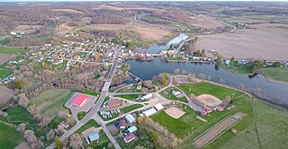
Bagley is a village in Grant County in the U.S. state of Wisconsin located on the Upper Mississippi River about 9 miles (15 km) south of Prairie du Chien, Wisconsin. The population was 379 at the 2010 census. It is a popular riverside destination in the summer, when the population can quadruple. The village was named for Vermont natives Alfred and Mary Bagley, who owned the site.

<span class="mw-page-title-main">River Hills, Wisconsin</span> Village in Milwaukee County, Wisconsin

River Hills is a village in Milwaukee County, Wisconsin, United States. The population was 1,602 at the 2020 census.

<span class="mw-page-title-main">Cazenovia, Wisconsin</span> Village in Wisconsin, United States

Cazenovia is a village in Richland and Sauk Counties in the U.S. state of Wisconsin. The population was 318 at the 2010 census. Of this, 314 were in Richland County, and only 4 were in Sauk County.

Richmond is a census-designated place (CDP) in the town of Richmond in Sagadahoc County, Maine, United States. The population was 1,864 at the 2000 census. It is part of the Portland–South Portland–Biddeford, Maine Metropolitan Statistical Area.

<span class="mw-page-title-main">Webster (village), New York</span> Village in New York, United States

Webster is a village in Monroe County, New York. The population was 5,399 at the time of the 2010 census. The village and town are named after orator and statesman Daniel Webster.

References

  1. McIntosh, William (1877). History of Monroe County, New York With Illustrations Descriptive of Its Scenery, Palatial Residences, Public Buildings, Fine Blocks, and Important Manufactories from Original Sketches by Artists of the Highest Ability (PDF). Philadelphia: J.B. Lippincott & Co. p. 186. OCLC   4975998 . Retrieved December 2, 2021.
  2. "ArcGIS REST Services Directory". United States Census Bureau. Retrieved September 20, 2022.
  3. 1 2 "History of Churchville". Archived from the original on February 6, 2006. Retrieved March 20, 2006.
  4. "US Gazetteer files: 2010, 2000, and 1990". United States Census Bureau. February 12, 2011. Retrieved April 23, 2011.
  5. "Census of Population and Housing". Census.gov. Retrieved June 4, 2015.
  6. "U.S. Census website". United States Census Bureau . Retrieved January 31, 2008.
  7. "School Districts Serving Chili, NY". Niche. Retrieved March 5, 2023.
  8. "Board of Trustees". www.churchville.net.
  9. "Planning Board | Village of Churchville" . Retrieved April 29, 2024.
  10. "Zoning Board of Appeals (ZBA) | Village of Churchville" . Retrieved April 29, 2024.
  11. "BAKER, Charles Simeon". Biographical Directory of the US Congress. Retrieved September 26, 2019.
  12. "Tim Redding Stats - Baseball-Reference.com". Baseball-Reference.com.
  13. "Jennifer Suhr". Archived from the original on October 25, 2015.
  14. "Jenn Suhr (@JennSuhr) - Twitter". twitter.com.
  15. "RocJocks: Lyndsay Wall broke hockey barriers".