Marceline, Missouri | |
---|---|
Coordinates: 39°43′00″N92°56′50″W / 39.71667°N 92.94722°W | |
Country | United States |
State | Missouri |
Counties | Linn, Chariton |
Government | |
• Mayor | Sallie Buck |
• City Manager | Richard Hoon |
Area | |
• Total | 3.32 sq mi (8.60 km2) |
• Land | 3.28 sq mi (8.50 km2) |
• Water | 0.04 sq mi (0.10 km2) |
Elevation | 866 ft (264 m) |
Population (2020) | |
• Total | 2,123 |
• Density | 647.06/sq mi (249.83/km2) |
Time zone | UTC-6 (Central (CST)) |
• Summer (DST) | UTC-5 (CDT) |
ZIP code | 64658 |
Area code | 660 |
FIPS code | 29-45866 [3] |
GNIS feature ID | 2395002 [2] |
Website | marcelinemo.us |
Marceline is a city in Chariton and Linn counties in the U.S. state of Missouri. The population was 2,123 at the 2020 census. [4]
Marceline was laid out in 1887, and named after the wife of a railroad man. [5] A post office called Marceline has been in operation since 1887. [6] Marceline is most famous for being the boyhood home of Walt Disney, and the original Main Street USA. [7]
Marceline is located at 39°42′52″N92°56′51″W / 39.71444°N 92.94750°W (39.714314, -92.947376). [8]
According to the United States Census Bureau, the city has a total area of 3.32 square miles (8.60 km2), of which 3.28 square miles (8.50 km2) is land and 0.04 square miles (0.10 km2) is water. [9]
Climate data for Marceline, MO | |||||||||||||
---|---|---|---|---|---|---|---|---|---|---|---|---|---|
Month | Jan | Feb | Mar | Apr | May | Jun | Jul | Aug | Sep | Oct | Nov | Dec | Year |
Record high °F (°C) | 74 (23) | 79 (26) | 86 (30) | 92 (33) | 98 (37) | 106 (41) | 116 (47) | 108 (42) | 103 (39) | 95 (35) | 82 (28) | 72 (22) | 116 (47) |
Mean daily maximum °F (°C) | 33 (1) | 40 (4) | 52 (11) | 63 (17) | 73 (23) | 82 (28) | 87 (31) | 85 (29) | 77 (25) | 67 (19) | 50 (10) | 37 (3) | 62 (17) |
Mean daily minimum °F (°C) | 14 (−10) | 19 (−7) | 30 (−1) | 40 (4) | 51 (11) | 61 (16) | 66 (19) | 64 (18) | 54 (12) | 43 (6) | 30 (−1) | 19 (−7) | 41 (5) |
Record low °F (°C) | −21 (−29) | −18 (−28) | −15 (−26) | 13 (−11) | 29 (−2) | 41 (5) | 46 (8) | 43 (6) | 30 (−1) | 16 (−9) | −7 (−22) | −24 (−31) | −24 (−31) |
Average precipitation inches (mm) | 1.50 (38) | 1.48 (38) | 2.74 (70) | 3.61 (92) | 4.78 (121) | 4.11 (104) | 4.74 (120) | 4.08 (104) | 4.38 (111) | 3.34 (85) | 2.96 (75) | 2.01 (51) | 39.73 (1,009) |
Average snowfall inches (cm) | 5.5 (14) | 4.2 (11) | 2.9 (7.4) | 0.4 (1.0) | 0 (0) | 0 (0) | 0 (0) | 0 (0) | 0 (0) | 0 (0) | 1 (2.5) | 4.4 (11) | 18.4 (46.9) |
Source: [10] |
Census | Pop. | Note | %± |
---|---|---|---|
1880 | 872 | — | |
1890 | 1,977 | 126.7% | |
1900 | 2,638 | 33.4% | |
1910 | 3,920 | 48.6% | |
1920 | 3,760 | −4.1% | |
1930 | 3,555 | −5.5% | |
1940 | 3,206 | −9.8% | |
1950 | 3,172 | −1.1% | |
1960 | 2,872 | −9.5% | |
1970 | 2,622 | −8.7% | |
1980 | 2,938 | 12.1% | |
1990 | 2,645 | −10.0% | |
2000 | 2,558 | −3.3% | |
2010 | 2,233 | −12.7% | |
2020 | 2,123 | −4.9% | |
U.S. Decennial Census [11] |
At the 2010 census there were 2,233 people, 970 households, and 606 families living in the city. The population density was 680.8 inhabitants per square mile (262.9/km2). There were 1,151 housing units at an average density of 350.9 per square mile (135.5/km2). The racial makeup of the city was 98.0% White, 0.3% African American, 0.1% Native American, 0.1% Asian, 0.2% from other races, and 1.3% from two or more races. Hispanic or Latino of any race were 1.4%. [12]
Of the 970 households 30.5% had children under the age of 18 living with them, 48.4% were married couples living together, 9.4% had a female householder with no husband present, 4.7% had a male householder with no wife present, and 37.5% were non-families. 34.0% of households were one person and 16.8% were one person aged 65 or older. The average household size was 2.30 and the average family size was 2.94.
The median age was 39.8 years. 25.1% of residents were under the age of 18; 7.7% were between the ages of 18 and 24; 22.8% were from 25 to 44; 26% were from 45 to 64; and 18.3% were 65 or older. The gender makeup of the city was 46.6% male and 53.4% female.
At the 2000 census there were 2,558 people, 1,079 households, and 690 families living in the city. The population density was 787.1 inhabitants per square mile (303.9/km2). There were 1,237 housing units at an average density of 380.6 per square mile (147.0/km2). The racial makeup of the city was 98.20% White, 0.12% African American, 0.78% Native American, 0.20% Asian, 0.20% from other races, and 0.51% from two or more races. Hispanic or Latino of any race were 0.82%. [3]
Of the 1,079 households 31.0% had children under the age of 18 living with them, 48.8% were married couples living together, 11.4% had a female householder with no husband present, and 36.0% were non-families. 32.4% of households were one person and 17.6% were one person aged 65 or older. The average household size was 2.32 and the average family size was 2.95.
The age distribution was 26.7% under the age of 18, 7.6% from 18 to 24, 24.4% from 25 to 44, 21.7% from 45 to 64, and 19.6% 65 or older. The median age was 39 years. For every 100 females, there were 84.7 males. For every 100 females age 18 and over, there were 78.2 males.
The median household income was $25,164 and the median family income was $35,948. Males had a median income of $26,786 versus $17,382 for females. The per capita income for the city was $15,086. About 9.0% of families and 13.1% of the population were below the poverty line, including 15.3% of those under age 18 and 19.5% of those age 65 or over.
Public education in Marceline is administered by the Marceline R-V School District. [13]
The Marceline Carnegie Library is a public library. [14]
Linn County is a county located in the northern portion of the U.S. state of Missouri. As of the 2020 census, the population was 11,874. Its county seat is Linneus. The county was organized January 1, 1837 and named after U.S. Senator Lewis F. Linn of Missouri.
Chariton County is a county located in the north-central portion of the U.S. state of Missouri. As of the 2020 census, the population was 7,408. Its county seat is Keytesville. The county was organized November 16, 1820, from part of Howard County and is named for the Chariton River.
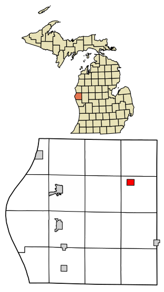
Walkerville is a village in Oceana County of the U.S. state of Michigan. The population was 247 at the 2010 census. The village is located within Leavitt Township.
Rothville is a village in northern Chariton County, Missouri, United States. The population was 63 at the 2020 census.
Alexandria is a city in eastern Clark County, Missouri, United States. As of the 2020 census, its population was 105.
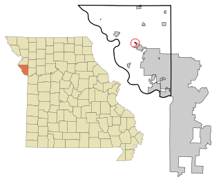
Brookfield is a city in Linn County, Missouri, United States. The population was 4,111 at the 2020 census.
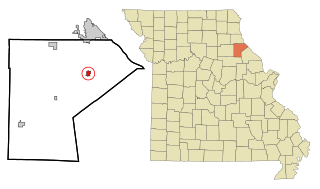
Bucklin is a city in southeast Linn County, Missouri, United States. The population was 413 at the 2020 census.
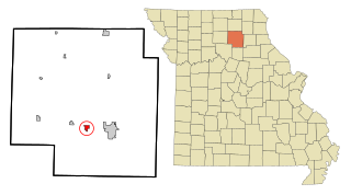
Linneus is a small city in Linn County, Missouri, United States. The population was 281 at the 2020 census. It is the county seat of Linn County.
Bevier is a city in Macon County, Missouri, United States. The population was 636 at the 2020 census.
Alton is a city and the county seat of Oregon County, Missouri, United States. The population was 707 at the 2020 census.
Parkville is a city in Platte County, Missouri, United States and is a part of the Kansas City Metropolitan Area. The population was 7,177 at the 2020 census. Parkville is known for its antique shops, art galleries, and historic downtown. The city is home to Park University, English Landing Park, Platte Landing Park, and the National Golf Club of Kansas City. Large neighborhoods in Parkville include: Riss Lake, The National, Thousand Oaks, Creekside, Parkville Heights, River Hills, Riverchase, The Bluffs, Downtown, and Pinecrest.
Tracy is a city in Platte County, Missouri within the United States, located along the Platte River. The population was 269 at the 2020 census. The city is part of the Kansas City metropolitan area.
New London is a city in Ralls County, Missouri, United States. The population was 943 at the 2020 census. It is the county seat of Ralls County.
Miami is a city in Saline County, Missouri, United States. The population was 175 at the 2010 census.
Greendale is a city in St. Louis County, Missouri, United States. The population was 651 at the 2010 census.
Northwoods is a city in St. Louis County, Missouri, United States. The population was 4,227 at the 2010 census.
Clarkson Valley is a city in St. Louis County, Missouri, United States. The population was 2,609 at the 2020 census.
Donnelsville is a village in Clark County, Ohio, United States. The population was 255 at the 2020 census. It is part of the Springfield, Ohio Metropolitan Statistical Area.
Cleves is a village in Miami Township, Hamilton County, Ohio, United States. Located along the Ohio River, it is a western suburb of Cincinnati. The population was 3,414 at the 2020 census.
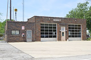
Berkey is a village in Lucas County, Ohio, United States. The population was 275 at the 2020 census.