Salisbury, Missouri

Last updated

Salisbury, Missouri
Chariton County Missouri Incorporated and Unincorporated areas Salisbury Highlighted.svg
Location of Salisbury, Missouri
Coordinates: 39°25′24″N92°48′09″W / 39.42333°N 92.80250°W / 39.42333; -92.80250
Country United States
State Missouri
County Chariton
FoundedApril 1, 1867
Area
[1]
  Total1.34 sq mi (3.47 km2)
  Land1.34 sq mi (3.47 km2)
  Water0.00 sq mi (0.00 km2)
Elevation
[2]
742 ft (226 m)
Population
 (2020)
  Total1,563
  Estimate 
(2023)
1,556
  Density1,168.16/sq mi (450.88/km2)
Time zone UTC-6 (Central (CST))
  Summer (DST) UTC-5 (CDT)
ZIP code
65281
Area code 660
FIPS code 29-65450 [3]
GNIS feature ID2396529 [2]

Salisbury is a city in Chariton County, Missouri, United States. The population was 1,563 at the 2020 census. [4]

Contents

History

Judge Lucius Salisbury, town founder JudgeSalisbury.JPG
Judge Lucius Salisbury, town founder

The land where Salisbury is now located was first owned by Prier Bibo, a veteran of the War of 1812. In 1819, a tract of 360 acres was granted to Bibo by the U.S. government as a bonus for his military service. [5] Following two intermediate owners, the land was sold for $400 to Judge Lucius Salisbury in 1856. He had surveyors lay out the town plat in 1857, and the town was founded on April 1, 1867.

Salisbury has had a post office since 1863, when Judge Salisbury opened it in his home. He also ran the stagecoach stop from his business, known as "Stop-A-While." [6]

By the 1870 U.S. Census, Salisbury's population was 626. Just two years later, the town was struck by a large tornado. Major fires damaged much of the business district in 1877 and again in 1882. On April 4, 1882, Salisbury was organized and chartered as a fourth-class city under Missouri laws. [6] [7]

Early businesses included two hotels, a flour mill, three tobacco factories, three manufacturers of agricultural equipment and some forty other assorted merchants in the latter 19th century. [5] Residents could visit the Salisbury Opera House, [6] where the town's location on the Wabash rail line came into play, conveniently bringing in notable performers of the time. A published 1896 history of Chariton County lists among the community's businesses and amenities two newspapers, six physicians, a soda-pop factory, cigar factory, and a city-owned power plant for electricity. [6]

The Salisbury Square Historic District and Frabrishous and Sarah A. Thomas House are listed on the National Register of Historic Places. [8]

Government

Salisbury is governed by a mayor-council form of government and is a 4th class city under Missouri classification. City council meetings are held the second Thursday of each month. In 2008 Salisbury's downtown area underwent major sidewalk and road work, with replica early 20th-century-style streetlights installed. Fire protection is provided by the Salisbury Fire Department, a volunteer-based organization. [9] A paid police department provides law enforcement services.

Education

Salisbury's second school building SalisburyMoSchool.JPG
Salisbury's second school building

The Salisbury R-IV school district provides K-12 education to the town of Salisbury and a portion of surrounding Chariton County. A major renovation and expansion project in 2010 and 2011 added more class space to the facility. Along with classrooms, construction of a tornado-safe multipurpose area including a new gymnasium is ongoing. Athletic teams from Salisbury High School have won multiple Missouri state championships: 1997 Class 1A football, 2001 and 2002 Class 2A softball, 2004 Class 1A boys' golf, 2012 Class 1A girls' cross county, [10] and 2012–2013 Class 2A boys' basketball. [11]

The first school in Salisbury opened in April 1867, with 108 students. A fire in 1888 destroyed the first school building and it was replaced by a much larger two-story brick structure. [6] In addition to the public school, Salisbury Academy, opened in 1888, provided for higher education at what today would be considered a junior college level. North Missouri Institute, another college-preparatory school, opened in 1891. [6]

Salisbury has a public library, the Dulany Memorial Library. [12]

Geography

Salisbury is located at the intersection of US Route 24 and Missouri Route 129. Keytesville is approximately seven miles to the west and Clifton Hill is about seven miles to the east in adjacent Randolph County along Route 24. The Middle Fork of the Little Chariton River flows past the southeast side of the city. [13]

According to the United States Census Bureau, the city has a total area of 1.33 square miles (3.44 km2), all land. [14]

Climate

Climate data for Salisbury, Missouri (1991–2020 normals, extremes 1946–present)
MonthJanFebMarAprMayJunJulAugSepOctNovDecYear
Record high °F (°C)75
(24)
81
(27)
86
(30)
93
(34)
97
(36)
104
(40)
114
(46)
107
(42)
103
(39)
95
(35)
82
(28)
73
(23)
114
(46)
Mean daily maximum °F (°C)37.1
(2.8)
42.5
(5.8)
53.9
(12.2)
65.1
(18.4)
75.0
(23.9)
83.9
(28.8)
87.8
(31.0)
86.7
(30.4)
80.0
(26.7)
68.0
(20.0)
53.9
(12.2)
41.9
(5.5)
64.6
(18.1)
Daily mean °F (°C)27.7
(−2.4)
32.4
(0.2)
43.0
(6.1)
53.8
(12.1)
64.4
(18.0)
73.8
(23.2)
77.4
(25.2)
75.8
(24.3)
68.0
(20.0)
56.0
(13.3)
43.4
(6.3)
32.8
(0.4)
54.0
(12.2)
Mean daily minimum °F (°C)18.3
(−7.6)
22.3
(−5.4)
32.1
(0.1)
42.6
(5.9)
53.7
(12.1)
63.6
(17.6)
67.1
(19.5)
64.8
(18.2)
55.9
(13.3)
44.0
(6.7)
32.9
(0.5)
23.7
(−4.6)
43.4
(6.3)
Record low °F (°C)−21
(−29)
−21
(−29)
−12
(−24)
15
(−9)
29
(−2)
40
(4)
46
(8)
36
(2)
25
(−4)
20
(−7)
−8
(−22)
−28
(−33)
−28
(−33)
Average precipitation inches (mm)1.52
(39)
1.84
(47)
2.79
(71)
4.04
(103)
5.15
(131)
5.54
(141)
4.21
(107)
3.64
(92)
3.73
(95)
3.49
(89)
2.43
(62)
1.64
(42)
40.02
(1,017)
Average precipitation days (≥ 0.01 in)5.34.87.59.69.88.57.96.66.27.36.15.585.1
Source: NOAA [15] [16]

Demographics

Historical population
CensusPop.Note
1870 626
1880 90845.0%
1890 1,67284.1%
1900 1,84710.5%
1910 1,834−0.7%
1920 1,757−4.2%
1930 1,7680.6%
1940 1,759−0.5%
1950 1,676−4.7%
1960 1,7876.6%
1970 1,9609.7%
1980 1,9750.8%
1990 1,881−4.8%
2000 1,726−8.2%
2010 1,618−6.3%
2020 1,563−3.4%
U.S. Decennial Census [17]

2010 census

As of the census [18] of 2010, there were 1,618 people, 698 households, and 431 families residing in the city. The population density was 1,216.5 inhabitants per square mile (469.7 inhabitants/km2). There were 830 housing units at an average density of 624.1 units per square mile (241.0 units/km2). The racial makeup of the city was 96.3% White, 2.1% African American, 0.5% Native American, 0.1% Asian, 0.1% from other races, and 0.9% from two or more races. Hispanic or Latino of any race were 0.2% of the population.

There were 698 households, of which 32.1% had children under the age of 18 living with them, 48.1% were married couples living together, 9.6% had a female householder with no husband present, 4.0% had a male householder with no wife present, and 38.3% were non-families. 34.5% of all households were made up of individuals, and 18.8% had someone living alone who was 65 years of age or older. The average household size was 2.31 and the average family size was 2.97.

The median age in the city was 40.2 years. 25.4% of residents were under the age of 18; 8.4% were between the ages of 18 and 24; 20.8% were from 25 to 44; 25.7% were from 45 to 64; and 19.7% were 65 years of age or older. The gender makeup of the city was 46.9% male and 53.1% female.

2000 census

As of the census [3] of 2000, there were 1,726 people, 744 households, and 474 families residing in the city. The population density was 493.6 inhabitants per square mile (190.6 inhabitants/km2). There were 847 housing units at an average density of 242.2 units per square mile (93.5 units/km2). The racial makeup of the city was 94.84% White, 4.23% African American, 0.17% Native American, 0.17% Asian, 0.06% from other races, and 0.52% from two or more races. Hispanic or Latino of any race were 0.58% of the population.

There were 744 households, out of which 29.7% had children under the age of 18 living with them, 52.4% were married couples living together, 9.0% had a female householder with no husband present, and 36.2% were non-families. 34.1% of all households were made up of individuals, and 20.4% had someone living alone who was 65 years of age or older. The average household size was 2.30 and the average family size was 2.93.

In the city, the population was spread out, with 24.2% under the age of 18, 6.7% from 18 to 24, 24.9% from 25 to 44, 21.6% from 45 to 64, and 22.7% who were 65 years of age or older. The median age was 42 years. For every 100 females, there were 84.8 males. For every 100 females age 18 and over, there were 81.8 males.

The median income for a household in the city was $30,729, and the median income for a family was $41,389. Males had a median income of $28,988 versus $19,185 for females. The per capita income for the city was $15,163. About 7.1% of families and 10.0% of the population were below the poverty line, including 10.4% of those under age 18 and 9.9% of those age 65 or over.

Notable person

Major Floyd Parks Floyd B. Parks.jpg
Major Floyd Parks

Attractions and events

Gallery: 19th-century Salisbury

Related Research Articles

<span class="mw-page-title-main">Chariton County, Missouri</span> County in Missouri, United States

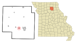
Chariton County is a county located in the north-central portion of the U.S. state of Missouri. As of the 2020 census, the population was 7,408. Its county seat is Keytesville. The county was organized November 16, 1820, from part of Howard County and is named for the Chariton River.

<span class="mw-page-title-main">Chariton, Iowa</span> City in Iowa, USA

Chariton is a city in, and the county seat of, Lucas County, Iowa, United States. The population was 4,193 at the 2020 census. Lucas is the primary distribution center for and the former corporate headquarters of the Hy-Vee supermarket chain.

<span class="mw-page-title-main">Williamson, Iowa</span> City in Iowa, United States

Williamson is a city in Lucas County, Iowa, United States. The population was 120 at the time of the 2020 census.

<span class="mw-page-title-main">Novinger, Missouri</span> Town in Missouri, United States

Novinger is a town in Nineveh Township, Adair County, Missouri, United States. The population was 456 at the 2010 census.

<span class="mw-page-title-main">Brunswick, Missouri</span> City in Missouri, United States

Brunswick is a city in Chariton County, Missouri, United States. Its population was 801 at the 2020 census. Brunswick, by official state proclamation, is the Pecan Capital of Missouri. The Missouri Farmers Association was founded in Brunswick in 1914.

<span class="mw-page-title-main">Keytesville, Missouri</span> City in Missouri, United States

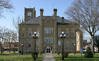
Keytesville is a city in and the county seat of Chariton County, Missouri, United States. The population was 440 as of the 2020 census. Keytesville is the hometown of U.S. Army General Maxwell D. Taylor, who commanded the "Screaming Eagles" 101st Airborne division during the Normandy invasion of World War II. Confederate General Sterling Price, who attacked Keytesville during an unsuccessful cavalry raid across his home state, had previously operated a hotel there.

<span class="mw-page-title-main">Mendon, Missouri</span> City in Missouri, United States

Mendon is a city in western Chariton County, Missouri, United States. The population was 163 at the 2020 census.

<span class="mw-page-title-main">Rothville, Missouri</span> Village in Missouri, United States

Rothville is a village in northern Chariton County, Missouri, United States. The population was 63 at the 2020 census.

<span class="mw-page-title-main">Sumner, Missouri</span> City in Missouri, United States

Sumner is a city in Chariton County, Missouri, United States. The population was 78 at the 2020 census. It was named in honor of U.S. Senator Charles Sumner.

<span class="mw-page-title-main">Triplett, Missouri</span> City in Missouri, United States

Triplett is a city in Chariton County, Missouri, United States. The population was 33 at the 2020 census.

<span class="mw-page-title-main">La Grange, Missouri</span> City in Missouri, United States

La Grange is a city in Lewis County, Missouri, United States. The population was 825 at the 2020 census. Since the 1960 census, the population has been dwindling. It is part of the Quincy, IL–MO Micropolitan Statistical Area.

<span class="mw-page-title-main">Bevier, Missouri</span> City in Missouri, United States

Bevier is a city in Macon County, Missouri, United States. The population was 636 at the 2020 census, down from 718 in 2010.

<span class="mw-page-title-main">Callao, Missouri</span> City in Missouri, United States

Callao is a city in Macon County, Missouri, United States. The population was 251 at the 2020 census, down from 292 in 2010.

<span class="mw-page-title-main">Elmer, Missouri</span> City in Missouri, United States

Elmer is a city in Macon County, Missouri, United States. The population was 51 at the 2020 census, down from 80 in 2010.

<span class="mw-page-title-main">Ethel, Missouri</span> Town in Missouri, United States

Ethel is a town in Macon County, Missouri, United States. The population was 41 at the 2020 census, down from 62 in 2010.

<span class="mw-page-title-main">New Cambria, Missouri</span> City in Missouri, United States

New Cambria is a city in Macon County, Missouri, United States. The population was 153 at the 2020 census, down from 195 in 2010.

<span class="mw-page-title-main">Livonia, Missouri</span> Village in Missouri, United States

Livonia is a village in eastern Putnam County, Missouri, United States. The population was 52 at the 2020 census.

<span class="mw-page-title-main">Green City, Missouri</span> City in Missouri, United States

Green City is a city in northeast Sullivan County, Missouri, United States. The population was 657 at the 2010 census.

<span class="mw-page-title-main">Scott, New York</span> Town in New York, United States

Scott is a town in Cortland County, New York, United States. The population was 1,176 at the 2010 census. The town was named after General Winfield Scott. It is in the northwestern corner of Cortland County and is northwest of the City of Cortland.

<span class="mw-page-title-main">Marceline, Missouri</span> City in Missouri, United States

Marceline is a city in Chariton and Linn counties in the U.S. state of Missouri. The population was 2,123 at the 2020 census.

References

  1. "ArcGIS REST Services Directory". United States Census Bureau. Retrieved August 28, 2022.
  2. 1 2 U.S. Geological Survey Geographic Names Information System: Salisbury, Missouri
  3. 1 2 "U.S. Census website". United States Census Bureau . Retrieved January 31, 2008.
  4. "Explore Census Data". data.census.gov. Retrieved December 21, 2021.
  5. 1 2 "A Directory of Towns, Villages, and Hamlets of Missouri". thelibrary.org.
  6. 1 2 3 4 5 6 Historical, Pictorial, & Biographical Record of Chariton County, Missouri, Pictorial and Biographical Publishing Co., Salisbury Missouri, 1896
  7. "Town history". City of Salisbury website. Archived from the original on February 24, 2013. Retrieved June 7, 2012.
  8. "National Register Information System". National Register of Historic Places . National Park Service. July 9, 2010.
  9. "Salisbury Fire Department". Firefighting News.com website. Retrieved June 15, 2012.
  10. "2012 Class 1 Girls' Championship Team Scores". Missouri State High School Activities Association. 2012. Retrieved March 2, 2013.
  11. "MSHSAA Boys' Class 2A State Tournament Bracket". Missouri State High School Activities Association. March 9, 2013. Retrieved March 9, 2013.
  12. "Missouri Public Libraries". PublicLibraries.com. Archived from the original on June 10, 2017. Retrieved June 4, 2019.
  13. Missouri Atlas & Gazetteer, DeLorme, 1998, First edition, p. 30, ISBN   0-89933-224-2
  14. "US Gazetteer files 2010". United States Census Bureau. Archived from the original on January 25, 2012. Retrieved July 8, 2012.
  15. "NowData – NOAA Online Weather Data". National Oceanic and Atmospheric Administration. Retrieved August 2, 2021.
  16. "Station: Salisbury, MO". U.S. Climate Normals 2020: U.S. Monthly Climate Normals (1991-2020). National Oceanic and Atmospheric Administration. Retrieved August 2, 2021.
  17. "Census of Population and Housing". Census.gov. Retrieved June 4, 2015.
  18. "U.S. Census website". United States Census Bureau . Retrieved July 8, 2012.
  19. 1 2 History (Clark Realty)
  20. "Salisbury Steak Festival 2012". City of Salisbury website. Archived from the original on February 24, 2013. Retrieved June 7, 2012.