
The Great Serpent Mound is a 1,348-foot-long (411 m), three-foot-high prehistoric effigy mound located in Peebles, Ohio. It was built on what is known as the Serpent Mound crater plateau, running along the Ohio Brush Creek in Adams County, Ohio. The mound is the largest serpent effigy in the world.

The Adena culture was a Pre-Columbian Native American culture that existed from 500 BCE to 100 CE, in a time known as the Early Woodland period. The Adena culture refers to what were probably a number of related Native American societies sharing a burial complex and ceremonial system. The Adena culture was centered on the location of the modern state of Ohio, but also extended into contiguous areas of northern Kentucky, eastern Indiana, West Virginia, and parts of extreme western Pennsylvania.

The Grave Creek Mound in the Ohio River Valley in West Virginia is one of the largest conical-type burial mounds in the United States, now standing 62 feet (19 m) high and 240 feet (73 m) in diameter. The builders of the site, members of the Adena culture, moved more than 60,000 tons of dirt to create it about 250–150 BC.

The Mathew Mound is a Native American mound in the southwestern part of the U.S. state of Ohio. Located off Oak Road near the village of Evendale, the mound is believed to have been built by members of the Adena or Hopewell peoples during the Woodland period.

The Turpin site (33Ha19) is an archaeological site in the southwestern portion of the U.S. state of Ohio. Located near Newtown in Hamilton County, the site includes the remains of a village of the Fort Ancient culture and of multiple burial mounds. Numerous bodies have been found in and around the mounds as a result of thorough site investigations. The archaeological value of the site has resulted in its use in the study of similar locations and in its designation as a historic site.
The Reeves Mound is a Native American mound in the southeastern part of the U.S. state of Ohio. Located north of the unincorporated community of Alfred, the mound is part of an archaeological site that appears to have been built by peoples of the Adena culture.
The David Stitt Mound is a Native American mound near Chillicothe in Ross County, Ohio, United States. Located on elevated land at a significant distance from the Scioto River, the mound is built in a sub-conical shape; it is 19.4 feet (5.9 m) high and has a diameter of approximately 130 feet (40 m).
The Etna Township Mounds are a pair of Native American mounds in Etna Township, Licking County, Ohio, United States. Located east of Reynoldsburg near Interstate 70, the mounds are built primarily of sand. Unlike typical Native American mounds, their location reveals nothing of their builders: they are not built atop hills or along a stream, as Adena mounds typically are.

The Highbank Park Works is a complex of earthworks and a potential archaeological site located within Highbanks Metro Park in Central Ohio in the United States. The park is in southernmost Delaware County on the east bank of the Olentangy River. The site is a semi-elliptical embankment, consisting of four sections, each 3 feet (0.91 m) high, and bordered by a shallow ditch. Two ravines and a 100-foot-high shale bluff surround the earthworks. It is thought to have been constructed sometime between 800 and 1300 CE by members of the Cole culture. The earthworks have seen little disturbance since the first white settlement of the region; agriculture has never been practiced on their vicinity, and no significant excavation has ever been conducted at the site. One small excavation and field survey, conducted in 1951, yielded a few pieces of pottery and flakes of flint from a small midden. Another excavation was conducted in 2011 that focused mainly on site usage and constructing a timeline for the mounds.
The Austin Brown Mound, also known as the "Dwight Fullerton Mound," is a subconical Native American mound located northwest of the city of Chillicothe in Ross County, Ohio, United States. In 1897, the Ohio Historical Society sponsored an excavation of the mound under the leadership of Clarence Loveberry, who oversaw the digging of a large tunnel into the mound's side. Loveberry's investigation yielded artifacts of the Adena culture and evidence of rotten logs on the floor of the mound, but in publishing the results of his excavation, he observed that neither a tomb nor any isolated burials were discovered within the mound. Since 1897, other Adena mounds have been excavated and shown to have wooden tombs in off-center locations, presumably to complicate the efforts of those who would loot the mounds; accordingly, it is possible that the Brown mound likewise has an off-center tomb.

The W.C. Clemmons Mound is a Native American mound in the south central portion of the U.S. state of Ohio. Located near the unincorporated community of Fox, it lies in the middle of a farm field near a creek. A cone measuring approximately 22 feet (6.7 m) high and 144 feet (44 m) in diameter, its shape is almost exactly circular.
The Snead Mound is a Native American mound in the southwestern portion of the U.S. state of Ohio. Located off U.S. Route 52 near the community of Neville, it lies in woodland atop a bluff. The mound is a conical structure measures approximately 5 feet (1.5 m) high and 55 feet (17 m) in diameter at the base; except for a small hole that may have been dug by a hunter, the mound appears never to have been disturbed since white settlement of the region.
The Theodore B. Schaer Mound is a Native American mound in the central part of the U.S. state of Ohio. Located southeast of the city of Canal Winchester in Fairfield County, it is a large mound; its height is 13 feet (4.0 m), and it is 60 feet (18 m) in diameter. Today, the mound sits in woodland, being covered with brush and trees. Since white settlement of the region, the mound has seen few changes: individuals hunting for Indian relics have damaged it slightly, but the most significant effects have been minor natural phenomena such as the diggings of groundhogs.

The Coon Hunters Mound is a Native American mound in the central part of the U.S. state of Ohio. Located near the village of Carroll, it sits on the grounds of the Central Ohio Coonhunters Association.
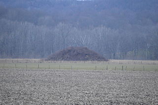
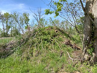
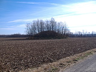
The Karshner Mound is a Native American mound in the southeastern portion of the U.S. state of Ohio. Located near the village of Laurelville in Hocking County, it is one of Ohio's largest remaining burial mounds that has not been significantly damaged since white settlement. Measuring 100 feet (30 m) in diameter and 28 feet (8.5 m) high, it lies in the middle of a farm field, but it has never been cultivated, and vegetation on the mound has prevented erosion.

The Hillside Haven Mound is a Native American mound in the southwestern part of the U.S. state of Ohio. Located southwest of Oakland in Clinton County, it sits in dense woodland on the side of a hill. It is believed to have been conical in shape at the time of construction, but today it is rounded in shape, measuring 2.5 feet (0.76 m) high and 33 feet (10 m) in diameter.
Indian Mound Reserve is a public country park near the village of Cedarville, Ohio, United States. Named for two different earthworks within its bounds — the Williamson Mound and the Pollock Works — the park straddles Massies Creek as it flows through a small canyon.

The Wright-Patterson Air Force Base Mound, designated 33GR31, is a Native American mound near the city of Dayton in Greene County, Ohio, United States. Named for its location on an Air Force facility, Wright-Patterson Air Force Base, the mound is an archaeological site.

The Cowan Creek Circular Enclosure (33CN11) is an earthworks complex in the southwestern part of the U.S. state of Ohio. Named for its location near the stream known as Cowan Creek, the enclosure is an important archaeological site, and it is protected as part of a state park.

The Stubbs Earthworks was a massive Ohio Hopewell culture archaeological site located in Morrow in Warren County, Ohio.

