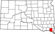
Clay County is a county in the U.S. state of South Dakota. As of the 2020 United States Census, the population was 14,967. The county seat is Vermillion, which is also home to the University of South Dakota. The county is named for Henry Clay, American statesman, US Senator from Kentucky, and United States Secretary of State in the 19th century.
Pine Ridge is a census-designated place (CDP) and the most populous community in Oglala Lakota County, South Dakota, United States. The population was 3,138 at the 2020 census. It is the tribal headquarters of the Oglala Sioux Tribe on the Pine Ridge Indian Reservation.
Bath is an unincorporated community and census-designated place in Brown County, South Dakota, United States. As of the 2020 census, Bath had a population of 142. Bath has been assigned the ZIP code of 57427.

Burbank is an unincorporated community and a census-designated place (CDP) in Clay County, South Dakota, United States. The population was 93 at the 2020 census. Burbank has been assigned the ZIP Code 57010.
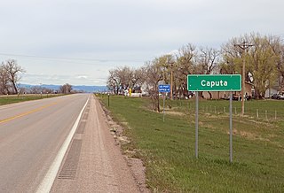
Caputa is an unincorporated community and census-designated place (CDP) in Pennington County, South Dakota, United States. It sits at an elevation of 2,907 feet (886 m). The population was 32 at the 2020 census. Caputa has been assigned the ZIP code of 57725.
Chester is an unincorporated community and census-designated place (CDP) in Lake County, South Dakota, United States. The population was 257 as of the 2020 census. Chester has been assigned the ZIP code of 57016.
Fedora is an unincorporated community in Miner County, South Dakota, United States, founded in 1881. The Census Bureau began tracking Fedora as a CDP in 2010. Fedora has been assigned the ZIP code of 57337. The population of the CDP was 26 at the 2020 census.
Lantry is an unincorporated community and a census-designated place (CDP) in Dewey County, South Dakota, United States. Lantry has been assigned the ZIP code of 57636. The population of the CDP was 33 at the 2020 census.
Lyons is an unincorporated community and census-designated place (CDP) in Minnehaha County, South Dakota, United States. The CDP had a population of 70 at the 2020 census. Lyons has been assigned the ZIP code of 57041.
Norris is an unincorporated community in Mellette County, South Dakota, United States, which is not specifically tracked by the Census Bureau, but rather is only included in the census-designated place of the same name. The population of the CDP was 150 at the 2020 census. Norris has the post office which serves the 57560 ZIP code area, which also includes the town of Corn Creek.
Okreek is an unincorporated community in Todd County, South Dakota, United States. As of the 2020 Census, the population was 190. The town is wholly within the jurisdiction of the Rosebud Indian Reservation, and the populace is almost entirely Sioux-American. Okreek consists primarily of two long blocks of inhabited tract housing, and has about 30 private telephone subscribers within town limits. There is also an elementary school and a Post Office which has been assigned the ZIP Code of 57563.
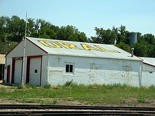
Oral is an unincorporated community and census-designated place (CDP) in Fall River County, South Dakota, United States. The population was 66 at the 2020 census.
Prairie City is an unincorporated community and census-designated place in Perkins County, South Dakota, United States. One of many rural settlements in Perkins County, the town was founded in 1946 by former residents of Strool. The population of the CDP was 25 at the 2020 census. The town has been assigned the ZIP code of 57649.
Saint Onge is an unincorporated community and census-designated place (CDP) in Lawrence County, South Dakota, United States. As of the 2020 census, the population was 170.
Smithwick is an unincorporated community and census-designated place (CDP) in Fall River County, South Dakota, United States. The population was 39 at the 2020 census. Smithwick has been assigned the ZIP code of 57782.
Stephan is an unincorporated community and census-designated place (CDP) in Hyde County, South Dakota, United States. Stephan has been assigned the ZIP code of 57346. The population of the CDP was 68 at the 2020 census.
Union Center is a small rural village in Meade County, South Dakota, United States. It is an unincorporated community, which was designated as part of the U.S. Census Bureau's Participant Statistical Areas Program on June 10, 2010. It was not counted separately during the 2000 Census, but is scheduled for inclusion in the 2010 Census. It has the post office which serves the area covered by ZIP code 57787, and three small businesses.
Winfred is an unincorporated community and census-designated place (CDP) in Lake County, South Dakota, United States, approximately 12 miles (19 km) west of Madison. The population was 38 as of the 2020 census. Winfred has been assigned the ZIP code of 57076.

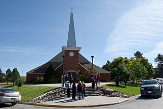
Agency Village is an unincorporated area and census-designated place (CDP) in Roberts County, South Dakota, United States. It is the headquarters of the Sisseton Wahpeton Oyate and home to Sisseton Wahpeton College. Since 2020, the CDP includes the community known as Goodwill. The population of the CDP was 776 at the 2020 census.
Forestburg is an unincorporated town and census-designated place in Sanborn County, South Dakota, United States. The population was 54 at the 2020 census.