
Rock Creek Station was a stagecoach and Pony Express station in southeastern Nebraska, three miles northeast of the present-day village of Endicott. The site is preserved as Rock Creek Station State Historical Park.
Pawnee State Recreation Area (SRA) is a state recreation area in southeastern Nebraska, United States. The recreation area surrounds the 740 acres (3.0 km2) Pawnee Lake, located approximately 4 miles (6.4 km) west of Lincoln. The recreation area is managed by the Nebraska Game and Parks Commission. Pawnee Lake is the second largest of the Salt Valley Lakes.
Branched Oak State Recreation Area (SRA) is a Nebraska state recreation area located 2.5 miles north of Malcolm, Nebraska (northwest of Lincoln) in Lancaster County. The lake is the largest of the Salt Valley Lakes with 1,800 acres (7 km2) of water in a 5,595-acre (23 km2) park.

Lewis and Clark Lake is a 31,400 acre (130 km²) reservoir located on the border of the U.S. states of Nebraska and South Dakota on the Missouri River. The lake is approximately 25 miles (40 km) in length with over 90 miles (140 km) of shoreline and a maximum water depth of 45 feet (14 m). The lake is impounded by Gavins Point Dam and is managed by the U.S. Army Corps of Engineers, Omaha District.

Niobrara State Park is a public recreation area located at the confluence of the Missouri and Niobrara rivers in the northeast corner of Nebraska. The state park occupies river bluffs to the west of the village of Niobrara and the Niobrara River. The park includes the Niobrara River Bridge, a decommissioned railroad bridge listed on the National Register of Historic Places. The park is managed by the Nebraska Game and Parks Commission.

Platte River State Park is a public recreation area encompassing 453 acres (183 ha) on the southern bluffs of the Platte River two miles (3.2 km) west of Louisville, Nebraska. The state park has a relatively steep, rolling topography compared to the surrounding region, with much of it forested.
Lake McConaughy is a reservoir on the North Platte River. It is located 9 miles (14 km) north of Ogallala, Nebraska, United States, near U.S. Highway 26 and Nebraska Highway 61. The reservoir was named for Charles W. McConaughy, a grain merchant and mayor of Holdrege, Nebraska, one of the leading promoters of the project. Although he did not live to see the completion of the project, his leadership and perseverance eventually culminated in a public power and irrigation project that helped Nebraska become one of the nation's leading agricultural states.
Dead Timber State Recreation Area is a Nebraska state park in Dodge County, Nebraska in the United States. The park is 200 acres (81 ha) and sits at an elevation of 1,266 feet (386 m). The park is open for year-round recreation including fishing, camping, and non-powered boating. Dead Timber State Recreation Area is north of Scribner on U.S. Route 275.
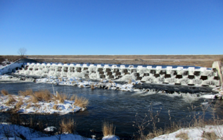
Virginia Smith Dam is a dam in Garfield County, Nebraska, about five miles northwest of Burwell.

Lake Yankton, also called Cottonwood Lake, is an artificial lake that was originally part of the main channel of the Missouri River on the border of the U.S. States of Nebraska and South Dakota, near Yankton, South Dakota. The lake has an approximate surface area of 250 acres (100 ha) and has a maximum depth of 18 feet (5.5 m). The lake is located immediately downstream (east) of Gavins Point Dam and Lewis and Clark Lake, located just north of the current location of the main channel of the Missouri River.
The Salt Creek Dams, are a U.S. Army Corps of Engineers water resource development project located in southeastern Nebraska near Lincoln, Nebraska, the state capitol. The project was authorized by the Federal Flood Control Act of 1958 to provide flood damage reduction, water quality, recreation, and fish and wildlife enhancement. The basin drains a 1645 square mile area of southeastern Nebraska, encompassing the City of Lincoln. Salt Creek enters the Platte River from the right bank 25 miles southwest of Omaha, Nebraska and drains the southern and western part of the basin, while Wahoo Creek drains the northeastern portion. The lakes are a part of the Missouri River basin.

Lewis and Clark State Recreation Area (SRA) is an 864-acre (350 ha) State Recreation Area located on the southern shore of Lewis and Clark Lake, in northeastern Nebraska. The recreation area is located in Knox County, approximately 12 miles (19 km) northwest of Crofton. The recreation area is managed by the Nebraska Game and Parks Commission.

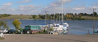
Fremont Lakes State Recreation Area (SRA) is a state park in eastern Nebraska, United States. The recreation area is located along the Platte River, approximately 3 miles (4.8 km) west of Fremont, or about 40 miles (64 km) northwest of Omaha. The recreation area is managed by the Nebraska Game and Parks Commission.
Willow Creek State Recreation Area (SRA) is a state park in northeastern Nebraska, United States. The recreation area is located on the 700 acre Willow Creek Reservoir, approximately 4 miles (6.4 km) southwest of Pierce, or about 15 miles (24 km) northwest of Norfolk. The recreation area is managed by the Nebraska Game and Parks Commission.
Box Butte Reservoir State Recreation Area (SRA) is a state park in northwestern Nebraska, United States. The recreation area is located on the 1,600 acre Box Butte Reservoir, a reservoir on the Niobrara River, approximately 9.5 miles (15.3 km) north of Hemingford and about 31 miles (50 km) southeast of Crawford. The recreation area is managed by the Nebraska Game and Parks Commission. There are camping, fishing, swimming, and other recreational opportunities available.
Bluestem State Recreation Area (SRA) is a state park in southeastern Nebraska, United States. The recreation area is located on the 325-acre Bluestem Reservoir, approximately 2.5 miles (4.0 km) west of Sprague, or about 18 miles (29 km) south of the State Capitol, Lincoln. The recreation area is managed by the Nebraska Game and Parks Commission. The area is popular for boating, fishing, camping, and swimming. The reservoir is stocked with largemouth bass, bluegill, channel catfish, walleye and crappies. There are 19 primitive campsites.
Stagecoach State Recreation Area (SRA) is a state recreation area in southeastern Nebraska, United States. The recreation area surrounds the 195-acre (0.79 km2) Stagecoach Lake, located approximately 20 miles (32 km) south of Lincoln. The recreation area is managed by the Nebraska Game and Parks Commission.
Medicine Creek State Recreation Area (SRA) is a state recreation area in southern Nebraska, United States. The recreation area surrounds the 1,768-acre Medicine Creek Reservoir also known as Harry Strunk Lake, a reservoir on Medicine Creek. The recreation area is managed by the Nebraska Game and Parks Commission. There are camping, fishing, swimming, and other recreational opportunities available.

